Orginal Article

A review on evapotranspiration data assimilation based on hydrological models

  • DONG Qingqing , 1 ,
  • *ZHAN Chesheng , 2 ,
  • WANG Huixiao 1 ,
  • WANG Feiyu 2, 3 ,
  • ZHU Mingcheng 1
Expand
  • 1. College of Water Sciences, Beijing Normal University, Beijing 100875, China
  • 2. Key Laboratory of Water Cycle and Related Land Surface Processes, Institute of Geographic Sciences and Natural Resources Research, CAS, Beijing 100101, China
  • 3. University of Chinese Academy of Sciences, Beijing 100049, China

Author: Dong Qingqing (1990-), Master Candidate, specialized in evapotranspiration data assimilation. E-mail:

*Corresponding author: Zhan Chesheng (1975-), Associate Professor, E-mail:

Received date: 2015-06-19

  Accepted date: 2015-07-21

  Online published: 2016-02-25

Supported by

National Key Basic Research Program of China (973 Program), No.2015CB452701

National Natural Science Foundation of China, No.41271003, No.41371043, No.41401042

Copyright

Journal of Geographical Sciences, All Rights Reserved

Abstract

Accurate estimation of evapotranspiration (ET), especially at the regional scale, is an extensively investigated topic in the field of water science. The ability to obtain a continuous time series of highly precise ET values is necessary for improving our knowledge of fundamental hydrological processes and for addressing various problems regarding the use of water. This objective can be achieved by means of ET data assimilation based on hydrological modeling. In this paper, a comprehensive review of ET data assimilation based on hydrological modeling is provided. The difficulties and bottlenecks of using ET, being a non-state variable, to construct data assimilation relationships are elaborated upon, with a discussion and analysis of the feasibility of assimilating ET into various hydrological models. Based on this, a new easy-to-operate ET assimilation scheme that includes a water circulation physical mechanism is proposed. The scheme was developed with an improved data assimilation system that uses a distributed time-variant gain model (DTVGM), and the ET-soil humidity nonlinear time response relationship of this model. Moreover, the ET mechanism in the DTVGM was improved to perfect the ET data assimilation system. The new scheme may provide the best spatial and temporal characteristics for hydrological states, and may be referenced for accurate estimation of regional evapotranspiration.

Cite this article

DONG Qingqing , *ZHAN Chesheng , WANG Huixiao , WANG Feiyu , ZHU Mingcheng . A review on evapotranspiration data assimilation based on hydrological models[J]. Journal of Geographical Sciences, 2016 , 26(2) : 230 -242 . DOI: 10.1007/s11442-016-1265-4

1 Introduction

Evapotranspiration (ET) is the main process controlling the water cycle and energy transport between the atmosphere, hydrosphere, and biosphere (Priestley and Taylor, 1972), and is an important subject of research on global and regional water and energy budgets (Rosenberg, 1983; Kustas and Norman, 1996; Vinukollu et al., 2011). Remote sensing and hydrological modeling are two key approaches to estimate evapotranspiration (Liu et al., 2007). Hydrological modeling is prone to errors due to uncertainties in input and output information, the model structure, initial conditions and model parameters, which affect the accuracy of the simulation (Renard et al., 2010). Using remote sensing to estimate ET has obvious advantages in accuracy and spatial resolution (Li et al., 2009), but cannot provide temporally continuous values and thus cannot meet the requirements of hydrological models (Liang et al., 2013). One possible approach to overcome these drawbacks involves applying multiple means or multi-source data to estimate ET, which is becoming the choice method for obtaining a continuous time series of ET with high precision (Conradt et al., 2013).
Data assimilation, as an advantageous technique for combining multi-source data, has been at the frontier of research on land surface hydrology and the water cycle (Song et al., 2011; Tang and Li, 2014) and has provided a new way of obtaining a highly accurate continuous time series of regional ET values. Pan et al. (2008) and Qin et al. (2008) applied the data assimilation technique and hydrological modeling to assimilate observed data, and this process improved the efficiency of the ET simulation, however, the assimilation effect was seriously affected by ET not being a state variable. Xie and Zhang (2010) assimilated flow into the Soil and Water Assessment Tool (SWAT) hydrological model, which did not significantly improve the accuracy of ET. The application of data assimilation based on hydrological models has made some progress (Xu et al., 2014) when the assimilated objects are primarily state variables; data assimilation for non-state variables, such as ET, is still being attempted (Spies et al., 2014). The potential of data assimilation in hydrological models should be further investigated. Therefore, we need to carry out studies of ET data assimilation based on hydrological models, and overcome the bottleneck for the use of the non-state variable ET when constructing data assimilation relationships, so as to obtain a highly precise continuous time series of ET values at the regional scale.
In this paper, a comprehensive review of evapotranspiration data assimilation based on hydrological modeling is provided. The difficulties and bottlenecks of using ET, being a non-state variable, to construct data assimilation relationships are elaborated upon, with a discussion and analysis of the feasibility of assimilating ET into various hydrological models. Based on this, a new easy-to-operate ET assimilation scheme that includes a water circulation physical mechanism is proposed. The scheme was developed with an improved data assimilation system that uses a distributed time-variant gain model (DTVGM), and the ET-soil humidity nonlinear time response relationship of this model. This scheme may provide a reference for an accurate simulation of regional evapotranspiration.

2 Evapotranspiration data assimilation

Data assimilation techniques, while only gradually being applied to hydrological simulations, have nevertheless recently become a hot research topic in the water cycle field. Data assimilation methods and their application to land surface and hydrological modeling have made several achievements in various systems, including the North American/Global Land Data Assimilation System (NLDAS/GLDAS) and European Land Data Assimilation System (ELDAS), as well as the assimilation systems in China, Canada and South Korea (Li et al., 2007). However, current research is mainly focused on state variables, such as soil moisture, leaf area index, etc., and relatively little on the non-state variable ET. Moreover, there has been little research on the emerging field of applying data assimilation in hydrology simulations for small-scale watersheds, and the potential of such data assimilation has not been fully realized (Moradkhani, 2008), especially for ET data assimilation based on hydrological models (Chen et al., 2013).
The amount of research dedicated to ET data assimilation began to ten years ago. Several papers have described attempts to use data assimilation techniques combined with various other models to estimate regional ET. Schuurmans et al. (2003) used ET estimates derived from remote sensing and the Surface Energy Balance Algorithm for Land (SEBAL) to improve distributed hydrological model (SIMGRO) simulations using a constant gain Kalman filter data assimilation algorithm, which calculated the state variable soil moisture using an empirical method after updating the ET value. In this study, the model was interpolated with ET observations relying on the calibration of empirical parameters, and hence was not statistically optimal. Pipunic et al. (2008) developed a data assimilation scheme with the ensemble Kalman filter (EnKF) to estimate latent heat flux and sensible heat flux based on a one-dimensional land surface model (LSM), which improved the simulation accuracy. However, assumptions in the LSM model have limited the popularity of this method. Qin et al. (2008) applied the extended Kalman filter to assimilate remote-sensing-derived ET estimates into a distributed hydrological model for improving the predictions of spatial water distribution over a large river basin, but the assimilation effect could not provide feedback into the model since ET is a non-state variable. The hydrological series had not been optimized as a whole, and was just equivalent to an interpolation. Irmak and Kamble (2009) proposed an assimilation methodology for the soil, water, atmosphere, and plant (SWAP) simulation model with remote sensing data from the SEBAL using genetic algorithm (GA) data assimilation. For this, uncertainty in the SEBAL model, due to its one evaporation mechanism, reduced the reliability of the methodology; besides, the assimilation method was virtually the further optimization of SWAP through genetic algorithm, no calibration between parameters within the SWAP model. Xie and Zhang (2010) tested a data assimilation system using streamflow to assimilate SWAT; this assimilation improved estimates of runoff and soil moisture, but not of ET. Dumedah and Coulibaly (2013) assimilated streamflow into the distributed hydrologic model (SWAT) using in-situ soil moisture data, and demonstrated some improvement in accuracy. However, the ET results were not effectively improved since the errors generated from the simulation were not completely corrected. Lei et al. (2014) assimilated synthetic surface soil moisture data into the SWAT model to evaluate their impact on other hydrological variables via the ensemble Kalman smoother (EnKS). The results showed that the assimilation of surface soil moisture can moderately improve estimates of deep layer soil moisture, surface runoff and lateral flow, while ET was still underestimated. Trudel et al. (2014) applied an ensemble Kalman filter into the distributed physically based hydrological model CATHY (CATchment HYdrology) to assimilate streamflow observations at different locations, as well as soil moisture at two different depths (15 and 45 cm). Assimilation of streamflow observations systematically increased the simulated soil moisture values, but no improvement in the accuracy of the ET sequence.
These studies have been useful for estimating evapotranspiration, but bottlenecks remain, and an ET assimilation system based on a hydrological model has not yet been established in practice. Effectively combining and integrating observations and simulations is necessary. That is, by using “true values” and minimizing errors to constrain model simulations, and by effectively merging information obtained from different sources with different spatial and temporal resolutions, higher resolution as well as spatially and temporally continuous data can then be obtained, which can yield a multi-scale representation of the water and energy cycle (Li et al., 2007).

3 Evapotranspiration data assimilation based on hydrological modeling

Hydrological modeling now pays more attention to the simulation of the generalized water cycle variables than previous, especially ET (Immerzeel and Droogers, 2008). A hydrological model that takes the water cycle system of a closed drainage basin as its study object can continuously simulate ET for every hydrologic unit (or space grid), and the temporal and spatial resolutions are flexible (Xu and Cheng, 2010). Moreover, it is physically based and easily applicable. If we can find a suitable hydrological model as the dynamic model of assimilation, continuous regional ET estimates may be achieved by assimilating this hydrological model. Methods used to estimate ET differ in different hydrological models, so constructing an ET assimilation system based on hydrological modeling is premised on taking full account of the relationship between ET (diagnostic variable) and other state variables, and then analyzing the feasibility of assimilating ET.
There are two groups of ET estimation methods in hydrological models: gathering methods and converting methods (Zhao et al., 2013). In both methods, ET is correlated with soil moisture, which is a state variable. Physically based hydrological models usually use gathering methods such as VIC and SHE to estimate ET; others commonly apply the converting methods, for which there are different ways to estimate potential ET and different soil moisture extraction functions. These functions are constructed based on soil moisture, and describe the relationship between ET and the state variables. A comparison of the feasibilities of the different hydrological models for ET assimilation is shown in Table 1.
Table 1 The comparison of the feasibilities of different hydrological models for evapotranspiration assimilation
ET, a non-state variable, is calculated for most of the hydrological models by using soil moisture. In addition to taking this state variable as an observation to influence the simulation of ET, data assimilation for hydrological modeling based on ET observations can be carried out in two ways. First, the observation operator AW=H (ET) associating soil moisture and ET can be constructed, which converts the observed ET into a state variable, so as to realize the direct assimilation. This approach can be used for various types of hydrological models, but requires extensive calculations. Moreover, rank-deficient problem may appear because the correlation between soil moisture and ET is not clear when calculating the covariance matrix. Second, we can construct a unit matrix operator ET = H (ET), assimilating the “observed” and simulated ET, and then calculate the state variable after updating ET. This method is easy to compute and rank-deficient problem does not appear. But it requires explicit relationships to be made between ET and state variables in the model, which is mainly applied to the model based on converting methods. Besides, the derivation of state variables is also worthy of attention. For example, in SWAT, soil moisture (which as mentioned above is a state variable) is the combined result of the entire duration of the simulation, so a sequential assimilation system of ET based on SWAT is difficult to construct. In other hydrological models based on converting methods, soil moisture evolves over time and can provide feedback of ET assimilation results, so we can first assimilate evapotranspiration, and then adjust soil moisture to calibrate the hydrological model. But it is hard to construct the sequential assimilation system without explicit relationships between ET and state variables. In addition, it is most convenient to directly assimilate simulated ET with observed ET under the conditions of few observations, since the assimilation efficiency is high when using a unit matrix.
To apply the assimilation procedures described above into hydrological models and determine ET levels with high precision, we should consider the requirements of the assimilation algorithm itself for hydrological models: first, the simulation variables must be state variables that can describe the time-domain behavior of a dynamic system; second, the simulation variable must evolve over time. In addition, ET is a prognostic variable to construct a data assimilation system, so we need to construct the time response relationship between ET and state variables by assimilating feedback and then optimizing the simulation, so as to obtain accurate estimates of ET. Thus, the key to construct an ET assimilation system is to select the hydrological model that meets the requirements of the assimilation algorithm, which means developing the time response relationship between ET and the state variable being used. By effectively transforming ET into a state variable, the hydrological model was modified by the assimilation conditions, and could be combined with sequential assimilation to establish a feasible ET data assimilation system.

4 A new evapotranspiration assimilation scheme based on hydrological modeling

To construct the data assimilation system based on evapotranspiration (ET), which is a non-state variable, we need to choose the hydrological model with a time response relationship between ET and the state variable, as the model operator of the assimilation system (Table 1). Based on the nonlinear theory of rain-derived flooding, and considering the preceding precipitation, Xia et al. put forward the distributed time-variant gain model (DTVGM) for watershed hydrological simulation (Xia et al., 1997; Xia, 2002; Xia et al., 2004). The model established the time response relationship between ET and soil moisture, and could be used to construct the data assimilation system based on ET. This section of the paper will use the DTVGM as an example to elaborate the new ET assimilation scheme.

4.1 Distributed time-variant gain model (DTVGM)

Xia et al. (2003) proposed the distributed time variant gain model (DTVGM) with a combination of a hydrological nonlinear system approach and distributed hydrological simulation technology, constructing the model structure from the perspective of feasibility and practicability. The DTVGM can simulate the nonlinear relationship between rainfall, runoff and other hydrological variables under the influence of human activities (Li et al., 2010), with the ability, using a small amount of computation, to provide a real-time response of underlying surfaces, especially in arid and semi-arid basins such as the Heihe and Yellow rivers (Xia et al., 2005). In this model, the soil moisture at a given point in time is calculated by the precipitation, surface runoff, soil moisture and actual ET at a previous point in time using the water balance equation, combined with a simple nonlinear relationship between actual ET and soil moisture, to effectively transform ET into a state variable. That is, the time response relationship of ET and soil moisture is constructed (Eqs. 1 and 2), and this construction is suitable for ET data assimilation.
where ETat is the actual evapotranspiration at time t; ETat+1 is the actual evapotranspiration at time t+1; Kr is soil water discharge coefficient; AWt is the soil moisture at time t; AWt+1 is the soil moisture at time t + 1; Wmin is the minimum soil moisture; ETpt+1 is the potential evapotranspiration at time t+1; WM is the saturated soil moisture; Pt is the precipitation at time t; RSt is the surface runoff at time t; and KAW is the coefficient of evapotranspiration conversion.

4.2 Improvement of DTVGM evapotranspiration estimation

The integrated converting method was used to calculate the actual ET in the DTVGM, and Zhao Lingling (2013) improved the ET formula by constructing a nonlinear soil water availability function based on the logistic distribution. A good estimation of actual ET was obtained based on the logistic function, not only in the winter and spring, when there is an adequate water supply, but also in summer, when the water content is low. The results indicate that the conversion model based on the logistic function has a wide range of applications, and can simulate the actual ET under various water supply conditions. The soil water availability function based on the logistic function is used to improve the ET formula in the DTVGM; then the improved time response relationship between ET and soil moisture can be described as:
where the meanings of the parameters are as described above. Eq. (3) completes the transition from ET to the state variable, i.e., soil moisture, yielding a forecast of soil moisture and updates of actual ET.
In order to improve the DTVGM, the time response relationship between ET and soil moisture will be further improved by considering the impact of vegetation (Zhao et al., 2014). Andersen believes that actual ET is related to potential ET, soil moisture, leaf area index and root depth (Andersen et al., 2002). Therefore, we use the leaf area index (or root depth) to improve the relationship between actual and potential ET in the DTVGM, thereby affecting the time response relationship of ET and soil moisture (Eq. (4)). Improving this relationship perfects the empirical ET formula and improves simulation accuracy, with better feedback and updates of the assimilation performance.
where f(LAI) is the leaf area index function, and f(RD) is the root depth function.

4.3 A new evapotranspiration assimilation scheme based on DTVGM

The new evapotranspiration assimilation scheme based on the DTVGM consists of three components: a dynamic model (model operator), a set of observations (observation operator) and assimilation algorithm. The improved DTVGM model can be used as a model operator, and the daily values of ET derived from remote sensing can be used as observed data. The implicit relationship between observed data and the state variable is contained in the assimilation process, and the ensemble Kalman filter algorithm can be chosen as the assimilation algorithm.
Using the ensemble Kalman filter (EnKF) algorithm, the ET data assimilation scheme takes ET values from remote sensing as observations, to correct the state variables and improve the performance of the DTVGM, which is the driving model. The specific processes of this assimilation scheme are as follows: 1) addition of perturbation model errors to generate the initial background field, and drive model simulation combined with the basic input data; 2) addition of perturbation errors to, when available, the observed data of the day, i.e., ET values derived from daily remote sensing, and then assembly of these data to obtain the observation field; 3) at the same time, assembly of the ET values from the model running in parallel to obtain the forecast field, and then assimilation of the forecast field and observation field by the ensemble Kalman filter algorithm to obtain the analysis field; 4) feedback provided by the assimilation effect to the model operator to replace and update the background field. Then the simulation of next day is driven, and the assimilation cycle begins again when there are observations in the next day (Figure 1).
Figure 1 The flow chart of ET assimilation based on distributed time-variant gain model
The ensemble Kalman filter (EnKF) can be used for the assimilation algorithm in this scheme. The main calculation steps are as follows:
(1) Forecast. The background field is initialized with N Gaussian random variables Xi (i=1, …, N), namely watershed actual ET, and the forecast is calculated for each random variable at time k+1 as follows:
where 
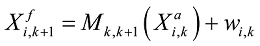
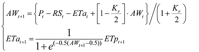
is the analysis of the ith ensemble member at time k, namely the ETa of the DTVGM simulation at time k; 
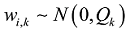
is the forecast of the ith ensemble member at time k+1, which uses the transition from ET to the soil moisture to obtain the ETa of the DTVGM simulation at time k+1; Mk,k+1 is the change of the state (which is generally a nonlinear model operator) from time k to k+1, and this change is the DTVGM in this scheme is the change of the relationship of state from time k to k+1, generally nonlinear model operator, and it is the DTVGM in this scheme; wi,k is the model error, drawn from normal distribution with zero mean and covariance matrix R.
(2) Update. The obtained state forecast is updated by the observations at time k+1 when available, and the updated state analysis and its error covariance are obtained. The process used to update ET can be expressed by Eq. (6).
where 
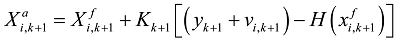
is the forecast of the ith ensemble member at time k+1, namely the ETa of the DTVGM simulation at time k+1; 
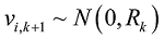
is the analysis of the ith ensemble member at time k+1, that is, the assimilated ET after the update that combines the model forecast and observations; Kk+1 is the Kalman gain matrix at time k+1 (Evensen, 2003), which weights the relative uncertainty of the simulated estimation and observation; yk+1 is the observations at time k+1, namely the ET measured by remote sensing; H(·) is the observation operator, being the unit matrix in the scheme; vi,k+1 is white Gaussian noise with zero mean and specified covariance Rk; and Rk is the observation error covariance matrix.
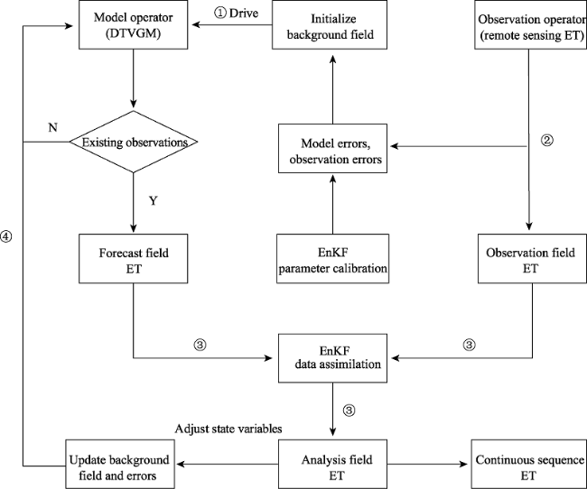
(3) Update background field. Initialize the model using the state estimation at time k+1. That is, update the background field by calculating the soil moisture according to assimilated ET, with the assimilating feedback to the model operator. When observations are available, the assimilation at the next point in time is executed, and the above steps are repeated until the forecast and update of the entire ET process is completed.
In summary, a new easy-to-operate evapotranspiration assimilation scheme with a water circulation physical mechanism has been proposed in this paper. Using ensemble Kalman filter, a data assimilation system that combined a remote sensing ET model and a hydrological model was constructed in the scheme depending on the time response relationship between ET and soil moisture in the DTVGM. This scheme can be expected to yield a continuous time series of regional ET estimates with high accuracy.

5 Discussion and prospect

In this paper, a new scheme to estimate evapotranspiration on a regional scale has been proposed. However, since the applications of this scheme are still at the experimental stage (Yin et al., 2014), more tests of these applications should be carried out at the regional level to validate the scheme. Research in ET data assimilation is still in the exploratory stage, and there are many bottlenecks that need to be overcome in this work, in contrast to assimilation research of other variables (e.g., land surface temperature, soil temperature, etc.). The biggest challenge in the assimilation of regional ET, a non-state variable in hydrological models, is how to improve the ET mechanism in the models as well as establish a rational isomorphic relationship of ET assimilation. Moreover, it is necessary to carry out further research on several aspects of this work, including on the accuracy of observational models, the stability of model operators, the capacity of data assimilation, the validation of regional ET processes, the optimization of the data assimilation method, the mechanism of the ET process and so on.
Accuracy of observational models. At present, most observational models adopt remote sensing (RS) ET models, which involve a number of parameters that describe the physical characteristics of the land surface. Due to external factors such as clouds, the atmosphere, the solar angle and observation angle, the accuracy of remote sensing data is limited to some extent. Besides, the cumulative effect of errors from retrieval of land surface parameters also affects the accuracy of observational models (Zhang et al., 2012). Therefore, it would be important to further explore the relationships between land surface physical characteristics and remote sensing information, so that we can reveal the basic laws underlying these relationships, and then realize cooperative retrieval of input data for the ET model using multi-source remote sensing information. This would improve the accuracy and spatio-temporal continuity of land surface parameters, so as to improve the accuracy of ET estimation at the regional scale.
Stability of model operators. The stability of model operators in data assimilation system, usually hydrological models, is of vital importance for obtaining accurate ET simulation results. Hydrological models synthetically consider the interactions between precipitation- runoff and landform, physiognomy, climate, and human activities. Since these models provide reliable mechanistic explanations for the hydrological cycle and use many parameters, uncertainties in these models have a great effect on ET simulation. Due to the high spatio-temporal heterogeneity of land surface variables, it is difficult to avoid large deviations between the hydrological model simulation and the observed data. Development of more mature, simple and effective model operators is necessary to achieve a reliable assimilation system. Therefore, further research is needed on the optimization and improvement of the hydrological model, as well as research on assessing the universality of the model. The convergence, rate of convergence and stability of the assimilation algorithm should also be comprehensively assessed.
Capacity of data assimilation. The capacity of data assimilation is closely related to the input frequency of “observations,” which means that an increase in the number of observed samples leads to better assimilation of ET, which promotes the influence of hydrological model calibration. When high-quality remote sensing data are lacking, it can be helpful to consider other sources of data, such as obtaining an observation field via spatial interpolation based on highly accurate flux data from regionally representative observational stations, moving/ fixed-point observations by radar remote sensing techniques, or calculation of energy flux by eliminating cloud interference for remote sensing data with large cloud coverage. These approaches will be the focus of future research.
Validation of the regional ET process. Direct comparison between assimilated ET and observed ET is the most efficient validation approach. Of these approaches, large-aperture scintillometry (LAS) is the most effective at a regional level, but a large-scale use of this method is often impeded by the high price of the equipment. The validation of actual ET still depends on the simulation data from a third party; thus, research focusing on finding an effective means of validating ET at the regional level is being carried out.
Development of data assimilation techniques. To further improve estimation of ET using hydrological models, it can be helpful in future research to use data fusion methods, such as the wavelet transform, to extract contact information between the grids of observational products and fuse them into the assimilation. Meanwhile, to enhance the accuracy of the estimation of hydrological variables and at the same time ensure high calculation efficiency, a more appropriate assimilation mechanism should be established. Research should be focused on the following: development of techniques to combine multiple and complementary remote sensing sources for hydrologic modeling (Xu et al., 2014); joint assimilation of multi-scale, multi-sensor products; and development of new techniques such as integration of new potential sensor products with hydrological models.

The authors have declared that no competing interests exist.

1
Andersen J, Dybkjaer G, Jensen K Het al., 2002. Use of remotely sensed precipitation and leaf area index in a distributed hydrological model.Journal of Hydrology, 264(1): 34-50.Remotely sensed precipitation from METEOSAT data and leaf area index (LAI) from NOAA AVHRR data is used as input data to the distributed hydrological modelling of three subcatchments (82,000 km 2 ) in the Senegal River Basin. Further, root depths of annual vegetation are related to the temporal and spatial variation of LAI. The modelling results are compared with results based on conventional input of precipitation and vegetation characteristics. The introduction of remotely sensed LAI shows improvements in the simulated hydrographs, a marked change in the relative proportions of actual evapotranspiration comprising canopy evaporation, soil evaporation and transpiration, while no clear trend in the spatial pattern could be found. The remotely sensed precipitation resulted in similar model performances with respect to the simulated hydrographs as with the conventional raingauge input. A simple merging of the two inputs did not result in any improvement.

DOI

2
Arnold J G, Williams J R, Srinivasan Ret al., 1998. Large area hydrologic modeling and assessment part I: Model development.Journal of the American Water Resources Association, 34(1): 73-89.ABSTRACT: A conceptual, continuous time model called SWAT (Soil and Water Assessment Tool) was developed to assist water resource managers in assessing the impact of management on water supplies and nonpoint source pollution in watersheds and large river basins. The model is currently being utilized in several large area projects by EPA, NOAA, NRCS and others to estimate the off-site impacts of climate and management on water use, non-point source loadings, and pesticide contamination. Model development, operation, limitations, and assumptions are discussed and components of the model are described. In Part II, a GIS input/output interface is presented along with model validation on three basins within the Upper Trinity basin in Texas.

DOI

3
Beven K, Calver A, Morris E M, 1987. The Institute of Hydrology Distributed Model, 1-33. Wallingford: Institute of Hydrology, 1-33.

(IH Report No.98)

4
Beven K J, Kirkby M J, 1979. A physically based, variable contributing area model of basin hydrology/Un modèle à base physique de zone d'appel variable de l'hydrologie du bassin versant.Hydrological Sciences Journal, 24(1): 43-69.

5
Beven K J, Kirkby M J, et al.Schofield N,1984. Testing a physically based flood-forecasting model (TOPMODEL) for three UK catchments.Journal of Hydrology, 69(1-4): 119-143.A previously developed model has been tested on three catchments: Crimple Beck (8 km ) near Harrogate, Hodge Beck (36 km ) on the North York Moors and the Wye headwater (10.5 km ) in central Wales. The model was originally validated on subcatchments within Crimple Beck. For this study forecasts were made over a period of one year, based only on rainfall and evaporation data. The model parameters were derived from a defined program of field measurements over a period of 2-4 weeks, and no formal optimization procedures were carried out before comparing forecasts with the measured stream discharge record. As a result of the comparisons, the model is seen as a useful approach for ungauged catchments of up to 500 km in humid-temperature climates.

DOI

6
Cao Lijuan, Liu Jingmiao, Ren Liliang, 2005. Improving on the evapotranspiration calculation of Xinanjinag model.Hydrology, 25(3): 5-9, 19. (in Chinese)

7
Chen H, Yang D, Hong Yet al., 2013. Hydrological data assimilation with the Ensemble Square-Root-Filter: Use of streamflow observations to update model states for real-time flash flood forecasting.Advances in Water Resources, 59: 209-220.

8
Conradt T, Wechsung F, Bronstert A, 2013. Three perceptions of the evapotranspiration landscape: Comparing spatial patterns from a distributed hydrological model, remotely sensed surface temperatures, and sub-basin water balances.Hydrology and Earth System Sciences Discussions, 10(1): 1127-1183.

9
Dumedah G, Coulibaly P, 2013. Evolutionary assimilation of streamflow in distributed hydrologic modeling using in-situ soil moisture data.Advances in Water Resources, 53: 231-241.The EDA was illustrated in an integrated assimilation approach to estimate model state using soil moisture, which in turn was incorporated into the soil and water assessment tool (SWAT) to assimilate streamflow. Soil moisture was independently assimilated to allow estimation of its model error, where the estimated model state was integrated into SWAT to determine background streamflow information before they are merged with perturbed observation data. Application of the EDA in Spencer Creek watershed in southern Ontario, Canada generates a time series of soil moisture and streamflow. Evaluation of soil moisture and streamflow assimilation results demonstrates the capability of the EDA to simultaneously estimate model state and parameterizations for real-time forecasting operations. The results show improvement in both streamflow and soil moisture estimates when compared to open-loop simulation, and a close matching between the background and the assimilation illustrates the forecasting performance of the EDA approach.

DOI

10
Evensen G, 2003. The Ensemble Kalman Filter: Theoretical formulation and practical implementation.Ocean Dynamics, 53(4): 343-367.lt;a name="Abs1"></a>The purpose of this paper is to provide a comprehensive presentation and interpretation of the Ensemble Kalman Filter (EnKF) and its numerical implementation. The EnKF has a large user group, and numerous publications have discussed applications and theoretical aspects of it. This paper reviews the important results from these studies and also presents new ideas and alternative interpretations which further explain the success of the EnKF. In addition to providing the theoretical framework needed for using the EnKF, there is also a focus on the algorithmic formulation and optimal numerical implementation. A program listing is given for some of the key subroutines. The paper also touches upon specific issues such as the use of nonlinear measurements, in situ profiles of temperature and salinity, and data which are available with high frequency in time. An ensemble based optimal interpolation (EnOI) scheme is presented as a cost-effective approach which may serve as an alternative to the EnKF in some applications. A fairly extensive discussion is devoted to the use of time correlated model errors and the estimation of model bias.

DOI

11
Feddes R A, Kowalik P, Kolinska-Malinka Ket al., 1976. Simulation of field water uptake by plants using a soil water dependent root extraction function.Journal of Hydrology, 31(1): 13-26.Water uptake by roots can be represented by adding a volumetric sink term to the continuity equation for soil-water flow. This sink term is often expressed as a product of the difference in pressure head between the soil and the root-soil interface, the hydraulic conductivity of the soil and some empirical root function. Because of the amount of field work and experimental difficulties involved in determining this root function, an attempt was made to describe the sink term with a more simple expression. In this approach the sink term is considered to be a function of the soil-water content, varying with the latter according to the pressure heads generally known to be critical for water uptake by the roots. An implicit finite-difference model was developed and verified with results obtained experimentally in the field from water-balance studies. Although the model does not predict the distribution of soil-water content with depth in very accurate detail, the cumulative effect over the entire depth is properly simulated. Comparison of the results of the simpler model with those of the model of Feddes, Bresler and Neuman, leads to the conclusion that both models yield comparable results.

DOI

12
Feddes R A, Kowallk P, Neuman S Pet al., 1976. Finite difference and finite element simulation of field water uptake by plants.Hydrological Sciences Journal, 21(1): 81-98.

13
Freeze R A, Harlan R L, 1969. Blueprint for a physically-based, digitally-simulated hydrologic response model.Journal of Hydrology, 9(3): 237-258.In recent years hydrologists have subjected the various subsystems of the hydrologic cycle to intensive study, designed to discover the mechanisms of flow and to arrive at physical and mathematical descriptions of the flow processes. As a consequence, meaningful results are now available in the form of numerical solutions to mathematical boundary value problems for groundwater flow, unsaturated porous media flow, overland flow, and channel flow. These developments in physical hydrology, together with the tremendous advance in digital computer technology, should provide the impetus for a necessary redirection of research in hydrologic simulation. In this paper, a blueprint for the development of physically-based hydrologic response models is presented; the level of sophistication that can be achieved with presently available methodology is discussed; and areas for necessary future research are pinpointed.

DOI

14
Hao Zhenchun, Li Li, Wang Jiahu et al., 2010. Theory and Method of Distributed Hydrological Model. Beijing: Science Press. (in Chinese)

15
Huang Yue, Chen Xi, Bao Anminget al., 2010. Distributed hydrological modeling in Kaidu Basin: MIKE-SHE model calibration and uncertainty estimation.Journal of Glaciology and Geocryology, 32(3): 567-572. (in Chinese)

16
Immerzeel W, Droogers P, 2008. Calibration of a distributed hydrological model based on satellite evapotranspiration.Journal of Hydrology, 349(3/4): 411-424.Calibrating spatially distributed hydrological models is complex due to the lack of reliable data, uncertainty in representing the physical features of a river catchment, and the implementation of hydrological processes in a simulation model. In this paper, an innovative approach is presented which incorporates remote sensing derived evapotranspiration in the calibration of the Soil and Water Assessment Tool (SWAT) in a catchment of the Krishna basin in southern India. The Gauss arquardt evenberg algorithm is implemented to optimise different combination of land use, soil, groundwater, and meteorological model parameters. In the best performing optimisation, the r 2 between monthly sub-basin simulated and measured actual evapotranspiration (ET act ) was increased from 0.40 to 0.81. ET act was more sensitive to the groundwater and meteorological parameters than the soil and land use parameters. Traditional calibration on a limited number of discharge stations lumps all hydrological processes together and chances on the equifinality problem are larger. In this study we have shown this problem can be constrained by using spatially distributed observations with a monthly temporal resolution. At a spatial resolution below the sub-basin level further study is required to fine-tune the calibration procedure.

DOI

17
Irmak A, Kamble B, 2009. Evapotranspiration data assimilation with genetic algorithms and SWAP model for on-demand irrigation.Irrigation Science, 28(1): 101-112.<a name="Abs1"></a>Evapotranspiration (ET) is one of the indicators of water use efficiency. Periodic information of ET based on remote sensing is useful for an on-demand irrigation (ODI) management. The main objective of this paper was to develop an ET data assimilation scheme to optimize the parameters of an agro-hydrology model for ODI scheduling. The soil, water, atmosphere, and plant (SWAP) simulation model has been utilized for this purpose. We computed remote sensing-based ET for a wheat field in the Sirsa Irrigation Circle, Haryana, in India using 18 cloud-free moderate resolution imaging spectroradiometer images taken between December 2001 and April 2002. The surface energy balance algorithm for land (SEBAL) was used for this purpose. Because ET estimates from SEBAL provide information on the surface soil moisture state, they were treated as observations to estimate unknown parameters of the SWAP model via a stochastic data assimilation (genetic algorithm) approach. The SWAP parameters were optimized by minimizing the residuals between SEBAL and SWAP model-based ET values. The optimized parameters were used as input to SWAP to estimate soil water balance for ODI scheduling. The results showed that the selected parameters (i.e. sowing, harvesting, and irrigation scheduling dates) were successfully estimated with the data assimilation methodology. The SWAP model produced reasonable states of water balance by assimilating ET observations. The root mean square of error was 0.755 and 2.132&nbsp;cm<sup>3</sup>/cm<sup>3</sup> for 0&#8211;15 and 15&#8211;30&nbsp;cm soil depths the same layers, respectively. With optimized parameters for ODI, SWAP predicted higher yield and water use efficiency than traditional farmer&#8217;s irrigation criteria. The data assimilation methodology produced can be considered as an operational tool at the field scale to schedule irrigation or predict irrigation requirements from remote sensing-based ET.

DOI

18
Kustas W P, Norman J M, 1996. Use of remote sensing for evapotranspiration monitoring over land surfaces.Hydrological Sciences Journal, 41(4): 495-516.Monitoring evapotranspiration (ET) at large scales is important for assessing climate and anthropogenic effects on natural and agricultural ecosystems. This paper describes techniques used in evaluating ET with remote sensing, which is the only technology that can efficiently and economically provide regional and global coverage. Some of the empirical/statistical techniques have been used operationally with satellite data for computing daily ET at regional scales. The more complex numerical simulation models require detailed input parameters that may limit their application to regions containing a large database of soils and vegetation properties. Current efforts are being directed towards simplifying the parameter requirements of these models. Essentially all energy balance models rely on an estimate of the available energy (net radiation less soil heat flux). Net radiation is not easily determined from space, although progress is being made. Simplified approaches for estimating soil heat flux appear promising for operational applications. In addition, most ET models utilize remote sensing data in the shortwave and thermal wavelengths to measure key boundary conditions. Differences between the radiometric surface temperature and aerodynamic temperature can be significant and progress in incorporating this effect is evident. Atmospheric effects on optical data are significant, and optical sensors cannot see through clouds. This has led some to use microwave observations as a surrogate for optical data to provide estimates of surface moisture and surface temperature; preliminary results are encouraging. The approaches that appear most promising use surface temperature and vegetation indices or a time rate of change in surface temperature coupled to an atmospheric boundary layer model. For many of these models, differences with ET observations can be as low as 20% from hourly to daily time scales, approaching the level of uncertainty in the measurement of ET and contradicting some recent pessimistic conclusions concerning the utility of remotely sensed radiometric surface temperature for determining the surface energy balance.

DOI

19
Lei F, Huang C, Shen Het al., 2014. Improving the estimation of hydrological states in the SWAT model via the ensemble Kalman smoother: Synthetic experiments for the Heihe River Basin in northwest China.Advances in Water Resources, 67: 32-45.

20
Li L, Xia J, Xu Cet al., 2010. Evaluation of the subjective factors of the GLUE method and comparison with the formal Bayesian method in uncertainty assessment of hydrological models.Journal of Hydrology, 390(3): 210-221.

21
Li Xin, Huang Chunlin, Che Taoet al., 2007. Progress and prospect of research on land data assimilation system in China.Progress in Natural Science, 17(2): 163-173. (in Chinese)

22
Li Z, Tang R, Wan Zet al., 2009. A review of current methodologies for regional evapotranspiration estimation from remotely sensed data.Sensors, 9(5): 3801-3853.ABSTRACT An overview of the commonly applied evapotranspiration (ET) models using remotely sensed data is given to provide insight into the estimation of ET on a regional scale from satellite data. Generally, these models vary greatly in inputs, main assumptions and accuracy of results, etc. Besides the generally used remotely sensed multi-spectral data from visible to thermal infrared bands, most remotely sensed ET models, from simplified equations models to the more complex physically based two-source energy balance models, must rely to a certain degree on ground-based auxiliary measurements in order to derive the turbulent heat fluxes on a regional scale. We discuss the main inputs, assumptions, theories, advantages and drawbacks of each model. Moreover, approaches to the extrapolation of instantaneous ET to the daily values are also briefly presented. In the final part, both associated problems and future trends regarding these remotely sensed ET models were analyzed to objectively show the limitations and promising aspects of the estimation of regional ET based on remotely sensed data and ground-based measurements.

DOI

23
Li Zhijia, Zhang Ke, Yao Cheng, 2006. Comparison of distributed geological models based on GIS technology and DEM.Journal of Hydraulic Engineering, 37(8): 1022-1028. (in Chinese)The GIS technology and Grid technology are used to improve the TOMODEL and Xinanjiang model for hydrological forecasting.A new model TOPMODEL based on DEM grid,namely GTOP-MODEL,another new model TOMODEL based on GIS and a improved Xinanjiang model are established.The models are applied to simulate the hydrological process of Luohe,a tributary of the Yellow River,and the parameters of these models are calibrated by the observation data.The suitability of GIS technology and corresponding models is investigated.The result shows that all these three models can well simulate the hydrological process of the river basin to be studied.Among them the GTOPMODEL model based on DEM grid technology is the best.

24
Liang Shunlin, Li Xin, Xie Xianhong et al., 2013. Land Surface Observations, Modeling and Data Assimilation. Beijing: Higher Education Press, 97-114. (in Chinese)

25
Liang X, Lettenmaier D P, Wood E Fet al., 1994. A simple hydrologically based model of land surface water and energy fluxes for general circulation models.Journal of Geophysical Research: Atmospheres, 99(D7): 14415-14428.A generalization of the single soil layer variable infiltration capacity (VIC) land surface hydrological model previously implemented in the Geophysical Fluid Dynamics Laboratory general circulation model (GCM) is described. The new model is comprised of a two-layer characterization of the soil column, and uses an aerodynamic representation of the latent and sensible heat fluxes at the land surface. The infiltration algorithm for the upper layer is essentially the same as for the single layer VIC model, while the lower layer drainage formulation is of the form previously implemented in the Max-Planck-Institut GCM. The model partitions the area of interest (e.g., grid cell) into multiple land surface cover types; for each land cover type the fraction of roots in the upper and lower zone is specified. Evapotranspiration consists of three components: canopy evaporation, evaporation from bare soils, and transpiration, which is represented using a canopy and architectural resistance formulation. Once the latent heat flux has been computed, the surface energy balance is iterated to solve for the land surface temperature at each time step. The model was tested using long-term hydrologic and climatological data for Kings Creek, Kansas to estimate and validate the hydrological parameters, and surface flux data from three First International Satellite Land Surface Climatology Project Field Experiment intensive field campaigns in the summer-fall of 1987 to validate the surface energy fluxes.

DOI

26
Liu Sanchao, Zhang Wanchang, Gao Maofanget al., 2007. Simulation of land surface evapotranspiration using distributed hydrological model, remote sensing and GIS technology.Scientia Geographica Sinica, 27(3): 354-358. (in Chinese)Evapotranspiration(ET) is the key factor to the research on water circulation and heat balance in the soil-vegetation-atmosphere system.In this article,a pixel based adapted DHSVM distributed hydrological model that integrates remote sensing and geographic information system was applied in the Ziwuhe River watershed in the upper Hanjiang River basin.The modeled pixel is 60 m large.Our study focused on the atmospheric and topographic correction on optical remote sensing data and utilizing 30 m resolution Landsat TM data to obtain leaf area index and the land use and land cover data.Some useful terrain factors as slope and aspect and topographic index could also be derived from digital elevation model.The results showed that the spatial pattern of ET was similarity in different temporal scales,moreover,it was found that daily ET spatial differences were more evident.The result also showed that the distributed model could be used in small basin of humid climate.

27
Mo X, Liu S, 2001. Simulating evapotranspiration and photosynthesis of winter wheat over the growing season. Agricultural and Forest Meteorology, 109(3): 203-222.A soil–vegetation–atmosphere process model is established to simulate water, energy and COfluxes. The model includes: (1) an improved multi-layer canopy radiative transfer submodel; (2) a new canopy conductance/photosynthesis submodel that distinguishes sunlit and shaded leaves; (3) a two-source soil–canopy energy balance submodel; (4) a multi-layer soil water and heat transfer submodel. The model is validated using two groups of data collected in a winter wheat field transitioning from recovering green through to maturity (in 1992) and from overwintering to maturity (in 1998) at Yucheng Experimental Station, Chinese Academy of Sciences in North China Plain. Satisfactory agreement is obtained between simulated and measured energy partitioning, surface temperature, root zone soil moisture, and canopy photosynthesis. Model-derived rates of daily crop transpiration and soil evaporation are in agreement with field measurements obtained via lysimeter and the Bowen ratio method. Sensitivity results show that the Leuning model of stomatal conductance/photosynthesis gives better evapotranspiration estimates than the Jarvis and Ball–Berry models. There are significant differences between the photosynthesis rates produced from our model and the corresponding rates calculated by the traditional “big leaf” model, which does not differentiate sunlit and shaded effects. However, both models generate fairly similar evapotranspiration rates. The successful simulation in 1998 was achieved using meteorological station data alone as driving force of the model instead of using micrometeorological data as in 1992 case, suggesting that the new model could have general applicability without the need for detailed micrometeorological data.

DOI

28
Moradkhani H, 2008. Hydrologic remote sensing and land surface data assimilation.Sensors, 8(5): 2986-3004.Accurate, reliable and skillful forecasting of key environmental variables such as soil moisture and snow are of paramount importance due to their strong influence on many water resources applications including flood control, agricultural production and effective water resources management which collectively control the behavior of the climate system. Soil moisture is a key state variable in land surface tmosphere interactions affecting surface energy fluxes, runoff and the radiation balance. Snow processes also have a large influence on land-atmosphere energy exchanges due to snow high albedo, low thermal conductivity and considerable spatial and temporal variability resulting in the dramatic change on surface and ground temperature. Measurement of these two variables is possible through variety of methods using ground-based and remote sensing procedures. Remote sensing, however, holds great promise for soil moisture and snow measurements which have considerable spatial and temporal variability. Merging these measurements with hydrologic model outputs in a systematic and effective way results in an improvement of land surface model prediction. Data Assimilation provides a mechanism to combine these two sources of estimation. Much success has been attained in recent years in using data from passive microwave sensors and assimilating them into the models. This paper provides an overview of the remote sensing measurement techniques for soil moisture and snow data and describes the advances in data assimilation techniques through the ensemble filtering, mainly Ensemble Kalman filter (EnKF) and Particle filter (PF), for improving the model prediction and reducing the uncertainties involved in prediction process. It is believed that PF provides a complete representation of the probability distribution of state variables of interests (according to sequential Bayes law) and could be a strong alternative to EnKF which is subject to some limitations including the linear updating rule and assumption of jointly normal distribution of errors in state variables and observation.

DOI PMID

29
Pan M, Wood E F, Wójcik Ret al., 2008. Estimation of regional terrestrial water cycle using multi-sensor remote sensing observations and data assimilation.Remote Sensing of Environment, 112(4): 1282-1294.An integrated data assimilation system is implemented over the Red-Arkansas river basin to estimate the regional scale terrestrial water cycle driven by multiple satellite remote sensing data. These satellite products include the Tropical Rainfall Measurement Mission (TRMM), TRMM Microwave Imager (TMI), and Moderate Resolution Imaging Spectroradiometer (MODIS). Also, a number of previously developed assimilation techniques, including the ensemble Kalman filter (EnKF), the particle filter (PF), the water balance constrainer, and the copula error model, and as well as physically based models, including the Variable Infiltration Capacity (VIC), the Land Surface Microwave Emission Model (LSMEM), and the Surface Energy Balance System (SEBS), are tested in the water budget estimation experiments. This remote sensing based water budget estimation study is evaluated using ground observations driven model simulations. It is found that the land surface model driven by the bias-corrected TRMM rainfall produces reasonable water cycle states and fluxes, and the estimates are moderately improved by assimilating TMI 10.67 GHz microwave brightness temperature measurements that provides information on the surface soil moisture state, while it remains challenging to improve the results by assimilating evapotranspiration estimated from satellite-based measurements.

DOI

30
Pipunic C, Walker P, Western A, 2008. Assimilation of remotely sensed data for improved latent and sensible heat flux prediction: A comparative synthetic study.Remote Sensing of Environment, 112(4): 1295-1305.Predicted latent and sensible heat fluxes from Land Surface Models (LSMs) are important lower boundary conditions for numerical weather prediction. While assimilation of remotely sensed surface soil moisture is a proven approach for improving root zone soil moisture, and presumably latent (LE) and sensible (H) heat flux predictions from LSMs, limitations in model physics and over-parameterisation mean that physically realistic soil moisture in LSMs will not necessarily achieve optimal heat flux predictions. Moreover, the potential for improved LE and H predictions from the assimilation of LE and H observations has received little attention by the scientific community, and is tested here with synthetic twin experiments. A one-dimensional single column LSM was used in 3-month long experiments, with observations of LE, H, surface soil moisture and skin temperature (from which LE and H are typically derived) sampled from truth model run outputs generated with realistic data inputs. Typical measurement errors were prescribed and observation data sets separately assimilated into a degraded model run using an Ensemble Kalman Filter (EnKF) algorithm, over temporal scales representative of available remotely sensed data. Root Mean Squared Error (RMSE) between assimilation and truth model outputs across the experiment period were examined to evaluate LE, H, and root zone soil moisture and temperature retrieval. Compared to surface soil moisture assimilation as will be available from SMOS (every 3days), assimilation of LE and/or H using a best case MODIS scenario (twice daily) achieved overall better predictions for LE and comparable H predictions, while achieving poorer soil moisture predictions. Twice daily skin temperature assimilation achieved comparable heat flux predictions to LE and/or H assimilation. Fortnightly (Landsat) assimilations of LE, H and skin temperature performed worse than 3-day moisture assimilation. While the different spatial resolutions of these remote sensing data have been ignored, the potential for LE and H assimilation to improve model predicted LE and H is clearly demonstrated.

DOI

31
Priestley C H B, Taylor R J, 1972. On the assessment of surface heat flux and evaporation using large-scale parameters.Monthly Weather Review, 100(2): 81-92.

32
Qin C, Jia Y, Su Zet al., 2008. Integrating remote sensing information into a distributed hydrological model for improving water budget predictions in large-scale basins through data assimilation.Sensors, 8(7): 4441-4465.

33
Refshaard J C, Storm B, Singh V P, 1995. MIKE SHE. In: Computer Models of Watershed Hydrology. Water Resources Publications, 809-846.

34
Renard B, Kavetski D, Kuczera Get al., 2010. Understanding predictive uncertainty in hydrologic modeling: The challenge of identifying input and structural errors.Water Resources Research, 46(5): W05521.1] Meaningful quantification of data and structural uncertainties in conceptual rainfall-runoff modeling is a major scientific and engineering challenge. This paper focuses on the total predictive uncertainty and its decomposition into input and structural components under different inference scenarios. Several Bayesian inference schemes are investigated, differing in the treatment of rainfall and structural uncertainties, and in the precision of the priors describing rainfall uncertainty. Compared with traditional lumped additive error approaches, the quantification of the total predictive uncertainty in the runoff is improved when rainfall and/or structural errors are characterized explicitly. However, the decomposition of the total uncertainty into individual sources is more challenging. In particular, poor identifiability may arise when the inference scheme represents rainfall and structural errors using separate probabilistic models. The inference becomes ill-posed unless sufficiently precise prior knowledge of data uncertainty is supplied; this ill-posedness can often be detected from the behavior of the Monte Carlo sampling algorithm. Moreover, the priors on the data quality must also be sufficiently accurate if the inference is to be reliable and support meaningful uncertainty decomposition. Our findings highlight the inherent limitations of inferring inaccurate hydrologic models using rainfall-runoff data with large unknown errors. Bayesian total error analysis can overcome these problems using independent prior information. The need for deriving independent descriptions of the uncertainties in the input and output data is clearly demonstrated.

DOI

35
Rosenberg N J, 1983. Microclimate: The Biological Environment. New York: John Wiley & Sons.

36
Schuurmans M, Troch A, Veldhuizen Aet al., 2003. Assimilation of remotely sensed latent heat flux in a distributed hydrological model.Advances in Water Resources, 26(2): 151-159.<h2 class="secHeading" id="section_abstract">Abstract</h2><p id="">This paper addresses the question of whether remotely sensed latent heat flux estimates over a catchment can be used to improve distributed hydrological model water balance computations by the process of data assimilation. The data used is a series of <span class="smallcaps">noaa-avhrr</span> satellite images for the Drentse Aa catchment in the Netherlands for the year 1995. These 1&times;1 km resolution images are converted into latent heat flux estimates using <span class="smallcaps">sebal</span> (<span class="smallcaps">s</span>urface <span class="smallcaps">e</span>nergy <span class="smallcaps">b</span>alance <span class="smallcaps">a</span>lgorithm for <span class="smallcaps">l</span>and [J Hydrol 2000;229:87]). The physically-based distributed model <span class="smallcaps">simgro</span> (<span class="smallcaps">sim</span>ulation of <span class="smallcaps">gro</span>undwater flow and surface water levels [J Hydrol 1997;192:158]) is used to compute the water balance of the Drentse Aa catchment for that same year. Comparison between model-derived and remotely sensed area-averaged evapotranspiration estimates show good agreement, but spatial analysis of the model latent heat flux estimates indicate systematic underestimation in areas with higher elevation. A constant gain Kalman filter data assimilation algorithm is used to correct the internal state variables of the distributed model whenever remotely sensed latent heat flux estimates are available. It was found that the spatial distribution of model latent heat flux estimates in areas with higher elevation were improved through data assimilation.</p>

DOI

37
Song Xiaomeng, Zhan Chesheng, Kong Fanzheet al., 2011. A review on uncertainty analysis of large-scale hydrological cycle modeling system.Acta Geographica Sinica, 66(3): 396-406. (in Chinese)The uncertainties in hydrological modelling come from four major sources: uncertainties in input data and parameters, uncertainties in model structure, uncertainties in analysis method and the initial and boundary conditions. Much attention has been paid to the uncertainty issues in hydrological modelling due to their great effects on prediction, and also many methods are applied to uncertainty quantification in the hydrological model. In this paper, we reviewed the recent advances on the uncertainty analysis approaches in the large-scale complex hydrological model, such as, large-scale hydrological system coupled with the land-atmosphere model. And then the PSUADE and its uncertainty quantification method were introduced, which will be a useful tool and platform for integration research in uncertainty analysis of large complex hydrological models.

38
Spies R R, Franz K J, Hogue T Set al., 2014. Distributed hydrologic modeling using satellite-derived potential evapotranspiration.Journal of Hydrometeorology, 16(1): 129-146.Satellite-derived potential evapotranspiration (PET) estimates computed from Moderate Resolution Imaging Spectroradiometer (MODIS) observations and the Priestley-Taylor formula (M-PET) are evaluated as input to the Hydrology Laboratory Research Distributed Hydrologic Model (HL-RDHM). The HL-RDHM is run at a 4-km spatial and 6-h temporal resolution for 13 watersheds in the upper Mississippi and Red River basins for 2003-10. Simulated discharge using inputs of daily M-PET is evaluated for all watersheds, and simulated evapotranspiration (ET) is evaluated at two watersheds using nearby latent heat flux observations. M-PET-derived model simulations are compared to output using the long-term average PET values (default-PET) provided as part of theHL-RDHMapplication. In addition, uncalibrated and calibrated simulations are evaluated for both PET data sources. Calibrating select model parameters is found to substantially improve simulated discharge for both datasets. Overall average percent bias (PBias) and Nash-Sutcliffe efficiency (NSE) values for simulated discharge are better from the default-PET than the M-PET for the calibrated models during the verification period, indicating that the time-varying M-PET input did not improve the discharge simulation in theHL-RDHM. M-PET tends to produce higher NSE values than the default-PET for the Wisconsin and Minnesota basins, but lower NSE values for the Iowa basins. M-PET-simulated ET matches the range and variability of observed ET better than the default-PET at two sites studied and may provide potential model improvements in that regard.

DOI

39
Tang H, Li Z L, 2014. Estimation and validation of evapotranspiration from thermal infrared remote sensing data. In: Quantitative Remote Sensing in Thermal Infrared. Berlin and Heidelberg: Springer, 145-201.As one of the most significant components in the hydrological processes (accounting for approximately 60 % of the mean precipitation globally), land surface evapotranspiration (ET, or latent heat flux, LE, in W/m 2 ) controls the water and energy transfer in the interface between land surface and atmosphere (Idso et al. 1975; Brutsaert 1986; Su 2002; Oki and Kanae 2006). Nowadays, measuring directly the actual ET remains unresolved over large heterogeneous areas in practical applications (Brutsaert 1986). Conventional ET measurements (i.e., sap flow, weighing lysimeter, pan measurement, Bowen ratio system, eddy correlation system, and scintillometer) are generally of limited use because of their spatial unrepresentativeness (with a fetch of 10 0 –10 3 m) and have difficulties in spatial extrapolation due to the significant surface heterogeneity. To date, remote sensing technology has been recognized as the most effective means to capture surface information at various spatial scales. Advantages in the remote sensing technology over the conventional “point” measurements include (1) its large and continuous spatial coverage within a few minutes, (2) its less cost when same spatial information is required, and (3) its benefit in ungauged areas (Engman and Gurney 1991; Rango 1994). Different combinations of the remote sensing spectral information from visible and near-infrared bands to mid and thermal infrared bands can produce surface characteristic parameters that are indispensable to ET models. These parameters consist of Normalized Difference Vegetation Index (NDVI), Leaf Area Index (LAI), fractional vegetation coverage (Fr), surface albedo, surface emissivity, and radiometric surface temperature (Mauser and Sch01dlich 1998).

DOI

40
Trudel M, Leconte R, Paniconi C, 2014. Analysis of the hydrological response of a distributed physically-based model using post-assimilation (EnKF) diagnostics of streamflow and in situ soil moisture observations.Journal of Hydrology, 514: 192-201.

41
Vázquez R F, 2003. Effect of potential evapotranspiration estimates on effective parameters and performance of the MIKE SHE-code applied to a medium-size catchment.Journal of Hydrology, 270(3): 309-327.

42
Vinukollu R K, Wood E F, Ferguson C Ret al., 2011. Global estimates of evapotranspiration for climate studies using multi-sensor remote sensing data: Evaluation of three process-based approaches.Remote Sensing of Environment, 115(3): 801-823.Three process based models are used to estimate terrestrial heat fluxes and evapotranspiration (ET) at the global scale: a single source energy budget model, a Penman-Monteith based approach, and a Priestley-Taylor based approach. All models adjust the surface resistances or provide ecophysiological constraints to account for changing environmental factors. Evaporation (or sublimation) over snow-covered regions is calculated consistently for all models using a modified Penman equation. Instantaneous fluxes of latent heat computed at the time of satellite overpass are linearly scaled to the equivalent daily evapotranspiration using the computed evaporative fraction and the day-time net radiation. A constant fraction (10% of daytime evaporation) is used to account for the night time evaporation. Interception losses are computed using a simple water budget model. We produce daily evapotranspiration and sensible heat flux for the global land surface at 5 km spatial resolution for the period 2003-2006. With the exception of wind and surface pressure, all model inputs and forcings are obtained from satellite remote sensing.<br/>Satellite-based inputs and model outputs were first carefully evaluated at the site scale on a monthly-mean basis, then as a four-year mean against a climatological estimate of ET over 26 major basins, and finally in terms of a latitudinal profile on an annual basis. Intercomparison of the monthly model estimates of latent and sensible heat fluxes with 12 eddy-covariance towers across the U.S. yielded mean correlation of 0.57 and 0.54, respectively. Satellite-based meteorological datasets of 2 m temperature (0.83), humidity (0.70), incident shortwave radiation (0.64), incident longwave radiation (0.67) were found to agree well at the tower scale, while estimates of wind speed correlated poorly (0.17). Comparisons of the four year mean annual ET for 26 global river basins and global latitudinal profiles with a climatologically estimated ET resulted in a Kendall's tau>0.70. The seasonal cycle over the continents is well represented in the How-libeller plots and the suppression of ET during major droughts in Europe, Australia and the Amazon are well picked up. This study provides the first ever moderate resolution estimates of ET on a global scale using only remote sensing based inputs and forcings, and furthermore the first ever multi-model comparison of process-based remote sensing estimates using the same inputs. (C) 2010 Elsevier Inc. All rights reserved.

DOI

43
Wang Kun, Mo Xingguo, Lin Zhonghuiet al., 2010. Improvement and validation of vegetation interface process model.Chinese Journal of Ecology, 29(2): 387-394. (in Chinese)<p>In order to improve the prediction capability of vegetation interface process (VIP) model, some parameterization schemes were updated, including the descriptions about the root depth with sinusoid of relative development stages, the root distribution density in soil depths, and the specific leaf area (SLA) variation in growth stages. The improved model was used to simulate the leaf area index, plant biomass, and soil moisture content at the Luancheng Agricultural Station in Hebei Province, and validated by the field observation data during the same periods. The results showed that the model performances in simulating soil moisture content, leaf area&nbsp; index, and other state variables were improved.</p>

44
Wang Yongfen, Mo Xingguo, HaoYanbinet al., 2008. Simulation seasonal and interannual variations of ecosystem evapotranspiration and its components in Inner Mongolia steppe with VIP model.Journal of Plant Ecology, 32(5): 1052-1060. (in Chinese)

45
Wu Mengying, Wang Zhonggen, Dang Suzhen, 2012. Simulation and analysis of runoff in the upper reaches of the Heihe River basin.Resources Science, 34(10): 1913-1921. (in Chinese)The Heihe River Basin is the second largest inland basin in China’s northwest arid region and is suffering from a number of severe water-related environmental problems because of drought, water shortages, global climate change and human activity. These problems are now constraining economic and social sustainable development. This paper constructed a distributed hydrological model based on the Hydro-Informatic Modeling System. The model achieved high accuracy during both simulation and verification. We simulated runoff for the Yingluo Valley hydrological station in the upper reaches of the Heihe River Basin under different climate change scenarios to quantitatively analyze the impact of future precipitation and temperature change on runoff. These data show that the a distributed hydrological model of the upper Heihe River based on the Hydro-Informatic Modeling System is suitable; both calibration and validation period Nash-Suttcliffe efficiency coefficient of day process model reached 0.80; both calibration and validation period Nash-Suttcliffe efficiency coefficient of month process model reached as high as 0.97. Annual runoff of the Yingluo Valley hydrological station and temperature were negativly correlated. Rising temperature causes earlier snowmelt time and increased evaporation. Annual runoff and precipitation were positively correlate, because precipitation is the direct source of runoff. If the amount of precipitation is constant, temperature influences runoff differently in different months because of temperature’s double effect on snowmelt time and evaporation. A temperature decrease of 2℃ will exacerbate the situation of the unequal distribution of runoff in one year. If the temperature is constant, monthly runoff will increase with increasing precipitation; but precipitation has little influence on runoff distribution patterns over one year. Annual runoff differences are obvious under different climate change scenarios. A temperature rise of 2℃ and precipitation fall by 20% is the most unfavorable condition for annual runoff. The most advantageous situation is that temperature falls 1℃ and at the same time precipitation increases 20%.

46
Xia J, O'Connor K M, Kachroo R Ket al., 1997. A non-linear perturbation model considering catchment wetness and its application in river flow forecasting.Journal of Hydrology, 200(1): 164-178.A non-linear perturbation model for river flow forecasting is developed, based on consideration of catchment wetness using an antecedent precipitation index (API). Catchment seasonality, of the form accounted for in the linear perturbation model (the LPM), and non-linear behaviour both in the runoff generation mechanism and in the flow routing processes are represented by a constrained nan-linear model, the NLPM-API. A total of ten catchments, across a range of climatic conditions and catchment area magnitudes, located in China and in other countries, were selected for testing daily rainfall-runoff forecasting with this model. It was found that the NLPM-API model was significantly more efficient than the original linear perturbation model (the LPM). However, restric tion of explicit nan-linearity to the runoff generation process, in the simpler LPM-API form of the model, did not produce a significantly lower value of the efficiency in flood forecasting, in terms of the model efficiency index R-2. (C) 1997 Elsevier Science B.V.

DOI

47
Xia Jun, 2002. Theory and Method of Hydrologic Nonlinearity. Wuhan: Wuhan University Press. (in Chinese)

48
Xia Jun, Wang Gangsheng, Lv Aifenget al., 2003. A research on distributed time variant gain modeling.Acta Geographica Sinica, 58(5): 789-796. (in Chinese)<p>Based on requirement of distributed hydrological modelling and considering the real conditions of the arid and semi-arid regions in China, this paper develops a Distributed Time Variant Gain Model (DTVGM) by coupling the mechanism and special digit information of water cycle with hydrologic system approach. It simulates the movement of the water in the soil-vegetation-atmosphere system, describes the relation between the cellular grids in the horizontal direction, and performs mathematical calculations of the surface water and the groundwater on the watershed cellular grids divided by DEM. DTVGM includes two components: one is runoff generation process on grid elements; the other is flow routing process based on ranked grids. At present, the runoff generation process is divided into two layers in the vertical direction: the upper layer is the surface flow; the lower layer is the subsurface flow. On the other hand, the kinematic wave models are applied to simulate the flow routing process. The article also addresses a case study on Heihe mountainous basin by applying DTVGM. The basin, with an area of 9,569.25 km2, is divided into 38,277 grid elements; and the grids are partitioned into 456 ranks for flow routing.</p>

49
Xia Jun, Wang Gangsheng, Tan Geet al., 2004. Hydrology nonlinear systems and distributed time-variant gain model. Science in China: Series D, 34(11): 1062-1071. (in Chinese)

50
Xia Jun, Ye Aizhong, Wang Gangsheng, 2005. A distributed time-variant gain model applied to Yellow River (I): Model theories and structures.Engineering Journal of Wuhan University, 38(6): 10-15. (in Chinese)According to the impact of climate changes and human activities on the flow regimes in the Yellow River,a distributed time-variant gain model(DTVGM) is developed.The large-scale DTVGM is a monthly water balance model and it is based on systems theory and physical mechanism.It can solve some hydrologic problems on predictions in ungauged basins(PUB).It has two sub-modules,natural runoff module and human activities module.

51
Xie X, Zhang D, 2010. Data assimilation for distributed hydrological catchment modeling via ensemble Kalman filter.Advances in Water Resources, 33(6): 678-690.<h2 class="secHeading" id="section_abstract">Abstract</h2><p id="">Catchment scale hydrological models are critical decision support tools for water resources management and environment remediation. However, the reliability of hydrological models is inevitably affected by limited measurements and imperfect models. Data assimilation techniques combine complementary information from measurements and models to enhance the model reliability and reduce predictive uncertainties. As a sequential data assimilation technique, the ensemble Kalman filter (EnKF) has been extensively studied in the earth sciences for assimilating in-situ measurements and remote sensing data. Although the EnKF has been demonstrated in land surface data assimilations, there are no systematic studies to investigate its performance in distributed modeling with high dimensional states and parameters. In this paper, we present an assessment on the EnKF with state augmentation for combined state-parameter estimation on the basis of a physical-based hydrological model, Soil and Water Assessment Tool (SWAT). Through synthetic simulation experiments, the capability of the EnKF is demonstrated by assimilating the runoff and other measurements, and its sensitivities are analyzed with respect to the error specification, the initial realization and the ensemble size. It is found that the EnKF provides an efficient approach for obtaining a set of acceptable model parameters and satisfactory runoff, soil water content and evapotranspiration estimations. The EnKF performance could be improved after augmenting with other complementary data, such as soil water content and evapotranspiration from remote sensing retrieval. Sensitivity studies demonstrate the importance of consistent error specification and the potential with small ensemble size in the data assimilation system.</p>

DOI

52
Xu X, Li J, Tolson B A, 2014. Progress in integrating remote sensing data and hydrologic modeling.Progress in Physical Geography. doi: 10.1177/0309133314536583.Remote sensing and hydrologic modeling are two key approaches to evaluate and predict hydrology and water resources. Remote sensing technologies, due to their ability to offer large-scale spatially distributed observations, have opened up new opportunities for the development of fully distributed hydrologic and land-surface models. In general, remote sensing data can be applied to land-surface and hydrologic modeling through three strategies: model inputs (basin information, boundary conditions, etc.), parameter estimation (model calibration), and state estimation (data assimilation). There has been an intensive global research effort to integrate remote sensing and land/hydrologic modeling over the past few decades. In particular, in recent years significant progress has been made in land/hydrologic remote sensing data assimilation. Hence there is a demand for an up-to-date review on these efforts. This paper presents an overview of research efforts to combine hydrologic/land models and remote sensing products (mainly including precipitation, surface soil moisture, snow cover, snow water equivalent, leaf area index, and evapotranspiration) over the past decade. This paper also discusses the major challenges remaining in this field, and recommends the directions for further research efforts.

DOI

53
Xu Zongxueet al., 2008. Hydrological Model. Beijing: Science Press. (in Chinese)

54
Xu Zongxue, Cheng Lei, 2010. Progress on studies and applications of the distributed hydrological models.Journal of Hydraulic Engineering, 1(3): 5-6. (in Chinese)Distributed hydrological model is an effective way to investigate and understand the processes and mechanism of complex hydrological cycles,and also an efficient tool to solve practical water problems.At present,water problems including floods,droughts,water pollution and soil erosion,as well as the occurrence of global climate change and digital hydrology,give a great challenge to the studies,development and applications of distributed hydrological models.Proceedings of the key issues in the field of hydrology and water resources,the state-of-the-art,the major progress and problems in studies and applications of distributed hydrological models are summarized.Possible tendency,major difficulties,and key technologies in the development of distributed hydrological models are also presented.

55
Yin Jian, Zhan Chesheng, Gu Honglianget al., 2014. A case study of evapotranspiration data assimilation based on hydrological model.Advances in Earth Science, 29(9): 1075-1084. (in Chinese)The quantitative estimation of watershed Evapotranspiration (ET) has been an international frontier in water sciences for a long time. Hydrological models and remote sensing ET models are usually used to estimate regional ET at different space-time scales, but these two methods are obviously insufficient to obtain precise and continuous regional ET. The hydrological models have the capability to simulate time-continuous daily or monthly ET processes, but the accuracy is not high compared with remote sensing ET models. The applicability of remote sensing ET models based on surface energy balance is restricted by the lack of high frequency and high resolution thermal data. A compromise between these two methodologies is represented by improving the optimization of hydrological models on the basis of a new ET series, which are produced by Data Assimilation (DA) scheme combining sparse remote estimates into the hydrological model. This study aimed to integrate the advantages of the two models to simulate the daily ET processes in Shahe River basin, Beijing. For this progect,the distributed hydrological model was fist constructed and the daily hydrological processes of 1999-2007 simulated. Then, the Ensemble Kalman Filter (EnKF) was used to assimilate the ET series calculated by remote sensing retrieval into the hydrological model to adjust the simulation. The results show that the ET estimation accuracy is improved after the data assimilation, and the MAPE between the DSM-based ETs and LAS-based ETs in the study area is reduced. The integrated method is proved better, and improves the hydrology modeling accuracy. Therefore, the project successfully develops a new land surface ET mode with the advantages of hydrological model and remote sensing ET model, and the study founds the new method could simulate regional ET with high accuracy and continuous time series. The new land surface ET model not only follows the surface energy balance, but also meets the regional water balance, and has more perfect water thermal coupling mechanism. The study will further enrich the content of ET estimation disciplines, and provide a scientific basis for better understanding of the laws of regional water cycle.

DOI

56
Yu Z, Deng J, Liu C, 2014. Application of VIC model to hydrological response caused by urbanization in Dongjiang Basin.Journal of Water Resources Research, 3(1): 78-83. (in Chinese)

57
Zhang Ronghua, Du Junping, Sun Rui, 2012. Review of estimation and validation of regional evapotranspiration based on remote sensing.Advances in Earth Science, 27(12): 1295-1307. (in Chinese)<p>Evapotranspiration (ET) is an important term of surface water-energy balance, and is a significant indicator of crop growth conditions and yield. Compared to the traditional evapotranspiration calculation methods, remote sensing technology is relatively economic, applicable and effective, and it has obvious advantages in monitoring evapotranspiration of heterogenous surface. Many remotely sensed data based models have been developed for regional evapotranspiration estimation during past years. Several frequently-used evapotranspiration models based on remote sensing data and their latest research progress were systematically reviewed first, which were categorized into five types: empirical statistical models, remote sensing models based on conventional methods, surface energy balance models, temperature-vegetation index feature space models, and land surface models and data assimilation. And then, different validation methods including lysimeter at several meters scale, bowen ratio and eddy flux tower at tens to hundreds of meters scale, Large Aperture Scintillometer (LAS) at hundreds to thousands of meters scale, and runoff observation at basin scale were summarized and analyzed. Finally, some existing problems, possible solutions of estimating regional evapotranspiration by remote sensing were analyzed in brief, and the research tendency was prospected. Synergic inversion of surface parameters based on multi-source remote sensing data, evapotranspiration model improvement and multi-model integration, land surface process and data assimilation, the spatial representativeness of observed latent flux and scale problem in the evapotranspiration estimation and validation need to be further studied in the future.</p>

58
Zhao Lingling, 2013. The evapotranspiration estimation methods study in hydrological cycle simulation [D]. Beijing: University of Chinese Academy of Sciences. (in Chinese)

59
Zhao Lingling, Xia Jun, Xu Chongyuet al., 2013. A review of evapotranspiration estimation methods in hydrological models.Acta Geographica Sinica, 68(1): 127-136. (in Chinese)Actual evapotranspiration is a key process of hydrological cycle and a sole term that links land surface water balance equation and land surface energy balance equation. Evapotranspiration plays a key role in simulating hydrological effect of climate change, and a review of evapotranspiration estimation methods in hydrological models is of vital importance. This paper firstly summarizes the evapotranspiration estimation methods in hydrological models and then classifies them into integrated discounting methods and classification gathering methods by their mechanism. Integrated discounting methods are usually used in hydrological models and two differences exist among these methods, one is in the potential evaporation estimation methods, and the other difference is the function for defining relationship between potential evaporation and actual evapotranspiration. Due to the higher information requirements of the Penman-Monteith method and the existing uncertainty in those data, simplified empirical methods for calculating potential and actual evapotranspiration are widely used in hydrological models. Different evapotranspiration calculation methods are used in different hydrological models, and importance and difficulty in the selection of most suitable evapotranspiration methods in various hydrological models with different complexity is discussed. Finally, this paper points out the development direction of the evapotranspiration estimating methods in hydrological models.

60
Zhao L W, Zhao W Z, 2014. Evapotranspiration of an oasis-desert transition zone in the middle stream of Heihe River, Northwest China.Journal of Arid Land, 6(5): 529-539.As a main component in water balance, evapotranspiration is of great importance for water saving and irrigation-measure making, especially in arid or semiarid regions. Although studies of evapotranspiration have been conducted for a long time, studies concentrated on oasis-desert transition zone are very limited. On the basis of the meteorological data and other parameters (e.g. leaf area index (LAI)) of an oasis-desert transition zone in the middle stream of Heihe River from 2005 to 2011, this paper calculated both reference (ET0) and actual evapotranspiration (ETc) using FAO56 Penman-Monteith and Penman-Monteith models, respectively. In combination with pan evaporation (Ep) measured by E601 pan evaporator, four aspects were analyzed: (1) ET0 was firstly verified by Ep; (2) Characteristics of ET0 and ETc were compared, while the influencing factors were also analyzed; (3) Since meteorological data are often unavailable for estimating ET0 through FAO56 Penman-Monteith model in this region, pan evaporation coefficient (Kp) is very important when using observed Ep to predict ET0. Under this circumstance, an empirical formula of Kp was put forward for this region; (4) Crop coefficient (Kc), an important index to reflect evapotranspiration, was also analyzed. Results show that mean annual values of ET0 and ETc were 840 and 221 mm, respectively. On the daily bases, ET0 and ETc were 2.3 and 0.6 mm/d, respectively. The annual tendency of ET0 and ETc was very similar, but their amplitude was obviously different. The differences among ET0 and ETc were mainly attributed to the different meteorological variables and leaf area index. The calculated Kc was about 0.25 and showed little variation during the growing season, indicating that available water (e.g. precipitation and irrigation) of about 221 mm/a was required to keep the water balance in this region. The results provide an comprehensive analysis of evapotranspiration for an oasis-desert transition zone in the middle stream of Heihe River, which was seldom reported before.

DOI

Outlines

/