Orginal Article

Exploring the relationship between vegetation and dust-storm intensity (DSI) in China

  • TAN Minghong
Expand
  • Key Laboratory of Ecosystem Network Observation and Modeling, Institute of Geographic Sciences and Natural Resources Research, CAS, Beijing 100101, China

Author: Tan Minghong, PhD and Associate Professor, E-mail:

Received date: 2015-03-18

  Accepted date: 2015-11-05

  Online published: 2016-04-25

Supported by

National Natural Science Foundation of China, No.41271119, No.91325302 No.41161140352 National Basic Research Program of China, No.2015CB452705

Copyright

Journal of Geographical Sciences, All Rights Reserved

Abstract

It is difficult to estimate the effects of vegetation on dust-storm intensity (DSI) since land surface data are often recorded aerially while DSI is recorded as point data by weather stations. Based on combining both types of data, this paper analyzed the relationship between vegetation and DSI, using a panel data-analysis method that examined six years of data from 186 observation stations in China. The multiple regression results showed that the relationship between changes in vegetation and variance in DSI became weaker from the sub-humid temperate zone (SHTZ) to dry temperate zone (DTZ), as the average normalized difference vegetation index decreased in the four zones in the study area. In the SHTZ and DTZ zones, the regression model could account for approximately 24.9% and 8.6% of the DSI variance, respectively. Lastly, this study provides some policy implications for combating dust storms.

Cite this article

TAN Minghong . Exploring the relationship between vegetation and dust-storm intensity (DSI) in China[J]. Journal of Geographical Sciences, 2016 , 26(4) : 387 -396 . DOI: 10.1007/s11442-016-1275-2

1 Introduction

Dust events exert various impacts on radiative forcing, human health, and agricultural production (Cyranoski, 2003; Prospero and Lamb, 2003; Prospero et al., 2012), and dust can be transported over thousands of kilometers (Fischer et al., 2009; Tan et al., 2012). So, the changes in dust-storm intensity (DSI) and the causative factors have been a central focus of much global research. In the existing literature, DSI is expressed by different measures. First, dust-storm frequency (DSF) is widely used as a measure of dust activity over a range of time scales (McTainsh et al., 2005; Yang et al., 2007; Goudie, 2009; Wang et al., 2004; Yumimoto et al., 2010; Liu and Liu, 2015). Second, the duration of dust storms has been used as a measure by some authors (Liu and Park, 2007); for example, Yao et al. (2011) analyzed the spatial differences in durations of dust storms in the Alxa Plateau of China from 1961 to 2005. Third, dust visibility or the concentration of dust is also used as a measure of DSI (McTainsh et al., 1998). Based on these studies, it is easy to infer that DSI has a close relationship with frequency, duration, and visibility of dust storms. Thus, some studies provide comprehensive measures of the intensity of dust storm (McTainsh et al., 2011; O’Loingsigh et al., 2014). For example, McTainsh et al. (2011) provide a composite measure of the intensity of dust storm, using the World Meteorological Organization’s (WMO) SYNOP codes. Tan et al. (2014) define the DSI of China by considering the frequency, duration, and visibility of dust storms.
The changes in DSI are affected by various factors including precipitation, temperature, wind speed, soil moisture (Prospero and Lamb, 2003; Gong et al., 2004; McTainsh et al., 2005; Yang et al., 2007). When examining these factors further, this study thinks that both land surface (e.g., dust source and low ground surface coverage) (Yang et al., 2007) and wind speed directly affect DSI (Xiao et al., 2008) (Figure 1). Human activities and environmental variables (e.g., precipitation, temperature) are mainly responsible for changes in vegetation and land surface (Xu et al., 2006; Cook et al., 2009; Wang et al., 2009).
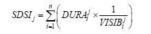
Figure 1 The factors causing changes in DSI
In earlier studies, the effect of climatic factors on DSF has attracted much attention, and factors such as precipitation, temperature, and wind speed have been quantitatively measured (McTainsh et al., 1998; Shao and Dong, 2006; Zhu et al., 2008) since they are all point data recorded by meteorological observation stations. In contrast, the effect of vegetation on dust storm activity has often been ignored, principally because dust events are often recorded as point data, while vegetation are recorded as aerial data. At present, little literature is focused on the effects of vegetation on DSI, although a few earlier studies have examined the relationship between vegetation and DSF (Engelstaedter et al., 2003; Xu et al., 2006).
Thus, this study calculated DSI in China, considering the frequency, duration, and visibility of dust events. Then, the relationship between vegetation and DSI was analyzed by combining the point data (DSI) and aerial data (vegetation), using multiple regression model.

2 Data and methods

2.1 Data

In this study, dust-storm data were gathered from 186 meteorological observation stations run by the China Meteorological Administration (CMA) (Figure 2). The data included geographical location of each observation station, wind speed, wind direction, the start and end times, and the visibility of each dust-storm event.
Vegetation indices such as the normalized difference vegetation index (NDVI) provide a much clearer description of vegetation (Kimura, 2012). In this paper, the NDVI remote sensing data were obtained from the National Oceanic and Atmospheric Administration's (NOAA) Advanced Very High Resolution Radiometer (AVHRR). The NDVI index consists of bi-weekly composite images at 8-km resolution.
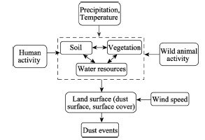
Figure 2 The distribution of 186 weather stations and desert land and sandy land, and the division of temperature zones in China. Note: The distribution map of desert land and sandy land in China is from the EESDC (2013).

2.2 Division of the temperature zone

Considering the vast differences in NDVI in different regions in northern China, this study divided the stations into four categories: SHTZ, semi-dry temperate zone (SDTZ), DTZ and Qinghai-Tibet zone (QTZ) (Figure 2). Thus, to analyze the effects of the NDVI on the DSI, four multiple regression models were developed in the above zones respectively. In each model, the selected variables were entered as a block in a single step of the SPSS software program.

2.3 Definition of DSI

According to the study by Tan et al. (2014), the sum value of the DSIs (SDSIj) of all dust events recorded by a station in year j can be expressed by the following equation:
where is the duration of dust event i at the station in year j, calculated with the end time and start time of the dust event, and is the visibility (in meters) of dust event i at the station in year j.
The CMA provided the dust event data from 1980 to 2007. Based on equation (1), the average value for SDSI across all 186 stations for each year can be calculated in this study. According to the time-series curve of SDSI, this study selected six years’ data (1983, 1988, 1993, 1998, 2003 and 2006) from 186 observation stations to examine the changes in NDVI and the effects on DSI, using a panel data-analysis method.

2.4 Combining the DSI and NDVI data

To combine the DSI and NDVI data, this study firstly built five buffers at 10 km, 20 km, 30 km, 40 km and 50 km from each station (Figure 3). Then, this study calculated the average values of the NDVI in the spring and the summer at the 5 buffers, respectively. Using a bivariate correlation model of an SPSS software package, the correlation coefficients of the DSI and the NDVI values were calculated. The model showed that the NDVI had a closer association with the DSI both in the spring and the summer in the 20-km buffer than in the other buffers. Thus, this study selected the NDVI variable in the 20-km buffer as the independent variable to explain the effect of the NDVI on the DSI (Table 1).
Table 1 Correlations between NDVI and DSI in the different buffers
SDSI Spr_10 Sum_10 Spr_20 Sum_20 Spr_30 Sum_30 Spr_40 Sum_40 Spr_50 Sum_50
SDSI 1 -0.168 -0.272 -0.172 -0.273 -0.166 -0.273 -0.163 -0.271 -0.158 -0.263
Spr_10 1 0.666 0.968 0.674 0.945 0.658 0.928 0.647 0.895 0.621
Sum_10 1 0.648 0.967 0.628 0.932 0.624 0.909 0.602 0.853
Spr_20 1 0.702 0.987 0.695 0.974 0.687 0.943 0.660
Sum_20 1 0.690 0.977 0.691 0.959 0.671 0.904
Spr_30 1 0.710 0.995 0.708 0.979 0.697
Sum_30 1 0.718 0.993 0.718 0.969
Spr_40 1 0.724 0.990 0.717
Sum_40 1 0.727 0.982
Spr_50 1 0.741
Sum_50 1

Note: Correlation is significant at the 0.01 level (2-tailed) for all variables. The variables from Spr_10 to Spr_50 in this table, were the average values of NDVI in the spring from 10 km to 50 km buffers, respectively. Similarly, the variable from Sum_10 to Sum_50 are the values in the summer in the previous year from 10 km to 50 km buffers, respectively. The variable of SDSI was calculated using the equation (1). The correlation coefficients of the DSI and the NDVI values were calculated, using a bivariate correlation model of an SPSS software package.

In the western and northern plateau areas in the study region, the low temperature and high altitude created a shorter growing season (July and August) (Duan et al., 2011). In August, the NDVI levels increased to a maximum value. Thus, the average values in July and August were therefore selected to represent the NDVI in the summer for the previous year, since vegetation components (roots, humus, etc.) in these two months can influence the soil texture during the subsequent winter months (Xu et al., 2006). In addition, because about 70% of the dust events occurred in March, April and May, the average of the NDVI values for these three months was then regarded as representative of the NDVI value for the spring of the current year.
As linearity is necessary in multiple regression analysis, this paper used logarithms of the independent variables, including the average NDVI values of summer (LnSum_20) and spring (LnSpr_20) in the 20-km buffer (Table 2). Given that an NDVI value may vary across grids in a buffer (Figure 3), the standard deviation values of the NDVI in the summer (Sum_20STD) and the spring (Spr_20STD) were regarded as independent variables (Table 2). The two variables were used to measure how much variation or dispersion from the average values of all grids in a buffer. A low value of standard deviation indicates that the data grids tend to be closer to the mean.
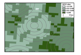
Figure 3 The NDVI values in five buffers
Table 2 The results of multi-regression analysis in different temperature zones of China
Model Non-standardized
coefficients
Standardized coefficients t Sig. Collinearity
statistics
B Std. Error Beta Tolerance VIF
SHTZ (Constant) 408.026 208.969 1.953 0.052
LnSum_20 -58.358 24.968 -0.145 -2.337 0.020 0.936 1.068
LnSpr_20 -15.210 27.548 -0.050 -0.552 0.581 0.430 2.326
Sum_20STD -0.008 0.266 -0.002 -0.029 0.977 0.852 1.174
Spr_20STD 0.057 0.521 0.010 0.110 0.912 0.407 2.457
Wind 1.867 1.016 0.126 1.838 0.068 0.759 1.318
V_1983 133.383 19.339 0.427 6.897 0.000 0.936 1.068
SDTZ (Constant) 2179.793 375.277 5.808 0.000
LnSum_20 -245.668 56.350 -0.288 -4.360 0.000 0.626 1.598
Lnspr_20 -112.639 83.428 -0.108 -1.350 0.178 0.427 2.341
Sum_20STD -1.764 0.733 -0.157 -2.406 0.017 0.639 1.566
Spr_20STD 1.891 1.329 0.112 1.423 0.156 0.444 2.253
Wind 0.002 0.009 0.009 0.167 0.868 0.993 1.007
V_1983 113.965 48.431 0.126 2.353 0.019 0.952 1.050
DTZ (Constant) 119.356 217.082 0.550 0.583
LnSum_20 -113.267 62.578 -0.250 -1.810 0.071 0.141 7.094
Lnspr_20 104.619 87.193 0.152 1.200 0.231 0.167 5.984
Sum_20STD 0.852 0.695 0.143 1.225 0.221 0.198 5.053
Spr_20STD -2.589 1.327 -0.193 -1.951 0.052 0.274 3.644
Wind 4.344 1.878 0.164 2.313 0.021 0.537 1.863
V_1983 85.220 46.245 0.100 1.843 0.066 0.912 1.096
QTZ (Constant) 1331.376 275.143 4.839 0
LnSum_20 -245.585 70.107 -0.458 -3.503 0.001 0.19 5.251
Lnspr_20 36.739 109.948 0.044 0.334 0.739 0.184 5.421
Sum_20STD 0.93 1.166 0.072 0.798 0.426 0.396 2.524
Spr_20STD 2.247 2.338 0.092 0.961 0.338 0.354 2.822
Wind -8.675 3.019 -0.184 -2.873 0.004 0.79 1.266
V_1983 118.291 70.748 0.102 1.672 0.096 0.87 1.15

Note: 1) The values of adjusted R2 in the SHTZ, SDTZ, DTZ and QTZ models were 0.249, 0.168, 0.086 and 0.165, respectively. 2) The tolerance is a measure of collinearity reported by SPSS software. A small value indicates that a predictor is redundant. The VIF is 1/tolerance.

In 1983, the DSI was significantly higher than that in the other years, so the dummy variable (V_1983) for 1983 was incorporated into the regression model. As discussed above, wind and vegetation directly affect the DSI. Thus, the average of annual wind speed (Wind) was selected as an independent variable in this study.

3 Results and discussion

3.1 Changes in DSI

The results show significant spatial differences in SDSI values in different sub-periods at the 186 stations. In spatial distribution, SDSIs of higher values were located mainly in the DTZ (Figure 4)—for instance, around the Mu Us Desert and Hobq Desert and the southern edge of the Taklimakan Desert in Xinjiang (Figures 2 and 4). For most observation stations, in 1983, the DSI values were much higher than those in the other years. However, Onqin Daq Desert in Inner Mongolia became one of the regions with the highest DSI value in 2006.
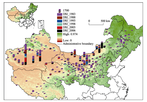
Figure 4 The values of SDSI in 1983, 1988, 1993, 1998, 2003 and 2006 at the 186 stations, and the distribution of the NDVI in the summer of 2005 in northern China

3.2 Relationship between NDVI and DSI

Improvement in vegetation cover can modify surface energy fluxes and water balance (D’Odorico et al., 2013), fix dunes, and reduce wind speeds (Torita and Satou 2007), thereby reduce DSI.
Table 2 also shows that LnSum_20 had a negative effect on the DSI in all the four models. This implied that the DSI decreased as the condition of the vegetation improved in the summer of the previous year. This is consistent with the study of Xu et al. (2006) which thinks vegetation components in the summer can influence the soil texture and dust activities during the subsequent winter months. On the contrary, in the four models, the LnSpr_20 had no close association with the DSI, which meant that the condition of the vegetation in the spring had no significant effects on DSI. The main reason is that the changes in the NDVI values could not been fully reflected in the spring, since the two months in March and April are not the growing season in many areas in the study region mainly due to low temperature. In addition, Figure 5 shows that the changes in the NDVI values in the summer were much larger than that in the spring. The average of the NDVI values in the 20-km buffer of 186 stations increased by 19.4% in the summer from 1983 to 2003, while the value only increased by 4.3% in the spring. The more rapid improvement in the summer may have more significant effects on the DSI.
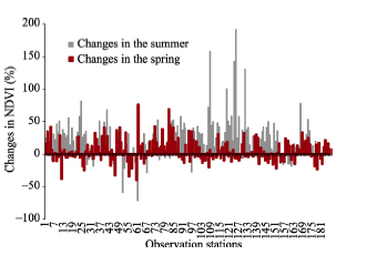
Figure 5 The changes in the average NDVI values in the 20-km buffer of 186 stations from 1983 to 2003
This is different from the existing literature. For instance, Liu et al. (2004) think the vegetation condition in the spring has a close relationship with the variation pattern of the spring DSF in northern China. In the study, the researchers do not discuss the effects of the vegetation condition in the summer on DSF.
In addition, in the SDTZ model only, the standard deviation of the NDVI in the summer (Sum_20STD) had a significant negative effect on the DSI, which meant that a uneven distribution of vegetation could decrease the DSI in the SDTZ. Similarly, in the DTZ model only, the standard deviation of the NDVI in the spring (Spr_20STD) had a negative relationship with the DSI at a 10% level of significance.
In all models, the dummy variable of V_1983 had a significant positive relationship with the dependent variable, since the DSI values in 1983 were much higher than those in the other years.
The Wind variable had significant influence on the DSI, except in the SDTZ model. In this study, the wind speed was the annual average value at every observation station, because it is difficult to obtain the wind speed data for every dust event. This may distort the true effect of wind speed on DSI, which may be one of the reasons that the Wind variable had no significant effect on the DSI in the SDTZ model. In the existing literature, strong wind is often regarded as one of three conditions for the formation of dust storms as well low ground surface coverage and rich dust source (Yang et al., 2007; Xiao et al., 2008). In the future study, it is necessary to collect the wind speed data for every event during the study of DSI.
Moreover, there is a clear relationship between the NDVI and the variance in DSI—the relationship weakened as the average NDVI value decreased in the four zones (Figure 6). Specifically, the average NDVI values in summer declined from 0.498 in the SHTZ zone to 0.227 in the DTZ zone for the selected six years, respectively. Correspondingly, the adjusted R2 values decreased from 0.249 in the SHTZ model to 0.086 in the DTZ model (Figure 6). Thus, the relationship between the NDVI and the DSI was strongest in the SHTZ model, and weakest in the DTZ model (Table 1). The SHTZ and DTZ models accounted for approximately 24.9% and 8.6% of the variance in DSI, respectively. Previous studies have shown similar results: the improved condition of the vegetation in the Chinese deserts within 200 mm/y and 400 mm/y precipitation zones decreased the surface dust concentrations by 10%-50% in most regions, using the Northern Aerosol Regional Climate Model for analyzing the distribution of dust storms in 2001 (Gong et al., 2004).
Figure 6 The average values of NDVI and the relationship between the NDVI and DSI in the DSI SHTZ, SDTZ, QTZ and DTZ models
The above discussion can provide some policy implications for combating desertification and reducing the damage of dust storms. In northern China, the vegetation improvement can more effectively decreased DSI, especially in the areas with high vegetation index, for instance in SHTZ. Furthermore, because these areas often have a higher population density and strong human activities, dust storms often cause more extensive damage, compared with the areas with low vegetation index (e.g., in dry temperate zone). Therefore, it may be more urgent and effective to strengthen reforestation and re-vegetation in these areas to decrease DSI and reduce the damage caused by dust events in the areas with a high vegetation index in northern China, such as in the zone of SHTZ.
In addition, using the same dust-storm data from the CMA, the previous-year precipitation and temperature can only explain about 5% of the changes in DSI (Tan et al., 2014). So, it would appear that vegetation may have a stronger effect on DSI than precipitation and temperature in the last several decades.

4 Conclusions

By combining DSI and NDVI data, this study firstly presented a method of building five buffers for each weather station. Then, using a bivariate correlation model, the average NDVI values in the 20-km buffer were chosen to explain the changes in DSI, since the values in both the spring and summer had higher correlation coefficients with the DSI in the 20-km buffer than the other buffers. Here, the DSI was defined comprehensively, taking into account the frequency, duration and visibility of dust events.
Based on developing a concept model for explaining the changes in DSI, this study thinks that vegetation and wind speed have a direct effect on DSI. These variables were used to interpret the changes in DSI, using a panel data-analysis method. This study found some interesting results:
First, there is a clear relationship between the NDVI and the variance in DSI. Furthermore, the relationship weakened as the average NDVI value decreased in the four zones. In the SHTZ, the relationship was the strongest, while it was weakest in the dry temperature zone. In the two regions, the models accounted for approximately 24.9% and 8.6% of the variance in the DSI, respectively. Thus, it may be more urgent and effective to strengthen reforestation and re-vegetation to decrease DSI and reduce the damage caused by dust events in the areas with higher vegetation index (e.g., the sub-humid temperate zone) in the northern China, because these areas have a higher population density and strong human activities.
Second, the condition of the vegetation in the summer of the previous year had a far more significant effect on the changes in DSI than that in the spring of the current year, because the latter can not fully reflect the changes in vegetation index. Moreover, the changes in the NDVI values in the summer were much larger than that in the spring. For instance, the average of the NDVI values in the 20-km buffer of 186 stations increased by 19.4% in the summer from 1983 to 2003, while the value only increased by 4.3% in the spring. The faster increase in vegetation conditions had more significant effects on the changes in DSI in the summer.
In addition, in the SDTZ, an uneven distribution of vegetation may decrease the intensity of dust storm, according to the model result in this study. This may be worthy of further study in the future.

The authors have declared that no competing interests exist.

1
Cook B I, Miller R L, Seager R, 2009. Amplification of the North American “Dust Bowl” drought through human-induced land degradation.PNAS, 106(13): 4997-5001.Abstract The "Dust Bowl" drought of the 1930s was highly unusual for North America, deviating from the typical pattern forced by "La Nina" with the maximum drying in the central and northern Plains, warm temperature anomalies across almost the entire continent, and widespread dust storms. General circulation models (GCMs), forced by sea surface temperatures (SSTs) from the 1930s, produce a drought, but one that is centered in southwestern North America and without the warming centered in the middle of the continent. Here, we show that the inclusion of forcing from human land degradation during the period, in addition to the anomalous SSTs, is necessary to reproduce the anomalous features of the Dust Bowl drought. The degradation over the Great Plains is represented in the GCM as a reduction in vegetation cover and the addition of a soil dust aerosol source, both consequences of crop failure. As a result of land surface feedbacks, the simulation of the drought is much improved when the new dust aerosol and vegetation boundary conditions are included. Vegetation reductions explain the high temperature anomaly over the northern U.S., and the dust aerosols intensify the drought and move it northward of the purely ocean-forced drought pattern. When both factors are included in the model simulations, the precipitation and temperature anomalies are of similar magnitude and in a similar location compared with the observations. Human-induced land degradation is likely to have not only contributed to the dust storms of the 1930s but also amplified the drought, and these together turned a modest SST-forced drought into one of the worst environmental disasters the U.S. has experienced.

DOI PMID

2
Cyranoski D, 2003, China plans clean sweep on dust storms,Nature, 421(9): 101.Not Available

DOI PMID

3
Environmental & Ecological Science Data Center for West China (EESDC), 2013.

4
Duan H, Yan C, Tsunekawa Aet al., 2011. Assessing vegetation dynamics in the Three-North Shelter Forest region of China using AVHRR NDVI data.Environ. Earth Sci., 64: 1011-1020.中国科学院机构知识库(中国科学院机构知识库网格(CAS IR GRID))以发展机构知识能力和知识管理能力为目标,快速实现对本机构知识资产的收集、长期保存、合理传播利用,积极建设对知识内容进行捕获、转化、传播、利用和审计的能力,逐步建设包括知识内容分析、关系分析和能力审计在内的知识服务能力,开展综合知识管理。

DOI

5
D’Odorico P, Bhattachan A, Davis Ket al., 2013. Global desertification: Drivers and feedbacks.Advances in Water Resources, 51: 326-344.Desertification is a change in soil properties, vegetation or climate, which results in a persistent loss of ecosystem services that are fundamental to sustaining life. Desertification affects large dryland areas around the world and is a major cause of stress in human societies. Here we review recent research on the drivers, feedbacks, and impacts of desertification. A multidisciplinary approach to understanding the drivers and feedbacks of global desertification is motivated by our increasing need to improve global food production and to sustainably manage ecosystems in the context of climate change. Classic desertification theories look at this process as a transition between stable states in bistable ecosystem dynamics. Climate change (i.e., aridification) and land use dynamics are the major drivers of an ecosystem shift to a “desertified” (or “degraded”) state. This shift is typically sustained by positive feedbacks, which stabilize the system in the new state. Desertification feedbacks may involve land degradation processes (e.g., nutrient loss or salinization), changes in rainfall regime resulting from land-atmosphere interactions (e.g., precipitation recycling, dust emissions), or changes in plant community composition (e.g., shrub encroachment, decrease in vegetation cover). We analyze each of these feedback mechanisms and discuss their possible enhancement by interactions with socio-economic drivers. Large scale effects of desertification include the emigration of “environmental refugees” displaced from degraded areas, climatic changes, and the alteration of global biogeochemical cycles resulting from the emission and long-range transport of fine mineral dust. Recent research has identified some possible early warning signs of desertification, which can be used as indicators of resilience loss and imminent shift to desert-like conditions. We conclude with a brief discussion on some desertification control strategies implemented in different regions around the world.

DOI

6
Engelstaedter S, Kohfeld K E, Tegen I, Harrison S P, 2003. Controls of dust emissions by vegetation and topographic depressions: An evaluation using dust storm frequency data.Geophysical Research Letters, 30(6): 1294. doi: 1210.1029/2002GL016471.1] The degree to which dust emissions are controlled by vegetation cover and geomorphic setting (specifically closed topographic depressions) was investigated using dust storm frequency (DSF) data based on visibility measurements from >2400 meteorological stations worldwide. Comparisons with distributions of vegetation types suggest that DSF is highest in desert/bare ground (median: 60–80 d/yr) and shrubland (median: 20–30 d/yr) regions, and comparatively low in grassland regions (median: 2–4 d/yr). Average DSF is inversely correlated with leaf area index (an index of vegetation density) and net primary productivity. In non-forested regions, DSF increases as the fraction of closed topographic depressions increases, likely due to the accumulation of fine sediments in these areas. These findings support the importance of incorporating vegetation and geomorphic setting as explicit controls on emissions in global dust cycle models.

DOI

7
Fischer E V, Hsu N C, Jaffe D Aet al., 2009. A decade of dust: Asian dust and springtime aerosol load in the U.S. Pacific Northwest.Geophysical Research Letters, 36: L03821. doi: 03810.01029/02008GL036467.Abstract Top of page Abstract 1.Introduction 2.Methods 3.Relationship Between Dust Emissions, PM 10 and PM 2.5 in the Western U.S. 4.Relationship Between Dust Emissions and PM at Select IMPROVE Sites 5.Interannual Variability in Trans-Pacific Transport 6.Impact of Regional Precipitation 7.Implications References Supporting Information [1] We integrate SeaWiFS aerosol optical thickness (AOT) over the Taklamakan and Gobi Deserts with U.S. aerosol observations to study surface aerosol variability in the Northwest U.S. in relation to Asian dust emissions. The results indicate that 鈭50% of the interannual variability in springtime average PM 2.5 and PM 10 can be explained by changes in Asian dust emissions. On a seasonal timescale, variations in dust emissions appear to be more important in determining the total material crossing the Pacific than the variations in meteorology represented by the PNA or the LRT3 indices. We are able to explain 鈭80% of the interannual variability using three variables: AOT, a transport index, and regional precipitation. This suggests that a strong source, favorable transport and sufficient residence time are needed for Asian dust to have a maximum seasonal impact in the Northwest. The results contextualize case studies and demonstrate the utility of the Deep Blue algorithm.

DOI

8
Gong S L, Zhang X Y, Zhao T Let al., 2004. Sensitivity of Asian dust storm to natural and anthropogenic factors.Geophysical Research Letters, 31: L07210. doi: 07210.01029/02004GL019502, 012004.The impacts of natural and anthropogenic factors on sand and dust storm distribution of 2001 in East Asia have been investigated by using the most up-to-date desertification map in China and desert reversal scenarios in natural precipitation zones. Here we show that although desertification in China has only increased total area of desert by ~2%-7% since 1950s [Zhong, 1999; Zhu and Zhu, 1999], it has generated disproportionably large areas with dust storm production potentials. Depending on the degree of desertification, newly formed deserts covered 15% to 19% of the original desert areas and would generate more dust storm, ranging from 10% to 40%, under the same meteorological conditions for spring 2001. Among the natural factors, the restoration of vegetation covers in the Chinese deserts within the 200 mm/y and 400 mm/y precipitation zones was found to decrease the surface mass concentrations by 10-50 % in most regions. It is also found that the contributions of surface concentrations from non-Chinese deserts account for up to 60% in Northeast China and up to 50% in Korea and Japan.

DOI

9
Goudie A S, 2009. Dust storms: Recent developments.Journal of Environmental Management, 90: 89-94.

10
Kimura R, 2012. Factors contributing to dust storms in source regions producing the yellow-sand phenomena observed in Japan from 1993 to 2002.Journal of Arid Environments, 80: 40-44.Asian-dust (yellow-sand) phenomena observed in Japan have been increasing in recent years, especially from 2000 to 2002. The main cause is severe dust events in arid and semi-arid regions of northeast Asia. The dust source area in northeast Asia (target area: 35°–45°N and 100°–115°E) was identified with reference to past results, and the relationship between the yellow-sand phenomena observed in Japan and dust outbreaks in the target area was examined during the springtime (March to May) from 1993 to 2002. The annual change in the number of dust phenomena observed in Japan agreed well with the Dust Storm Frequency (DSF) in the target area ( R 2 =0.8796). Even though strong wind (≧7.0ms 611 ) has a profound effect on dust storms ( R 2 =0.515), coverage of the Normalized Differential Vegetation Index (NDVI), ranging from 0 to 0.1 (bare land with snow cover) and 0.1 to 0.2 (bare land) in April, also affected dust storms in the target area ( R 2 =0.486 and 0.418).

DOI

11
Liu G, Park S-U, 2007. The logarithm-linear relationship of the occurrence frequency to the duration of sand-dust storms: Evidence from observational data in China.Journal of Arid Environments, 71: 243-249.

12
Liu X, Yin Z, Zhang Xet al., 2004. Analyses of the spring dust storm frequency of northern China in relation to antecedent and concurrent wind, precipitation, vegetation, and soil moisture conditions. Journal of Geophysical Research, 109: doi: 10.1029/2004JD004615.

13
Liu Y, Liu R, 2015. Climatology of dust storms in northern China and Mongolia: Results from MODIS observations during 2000-2010.Journal of Geographical Sciences, 25(11): 1298-1306.

DOI

14
McTainsh G, Chan Y-C, McGowan Het al., 2005. The 23rd October 2002 dust storm in eastern Australia: Characteristics and meteorological conditions.Atmospheric Environment, 39: 1227-1236.lt;h2 class="secHeading" id="section_abstract">Abstract</h2><p id="">The dust storm of 23 October 2002 covered most of eastern Australia and carried one of the largest recorded dust loads in Australia. In the 6 months leading up to the event, severe drought conditions in eastern Australia, plus above average maximum temperatures resulted in high potential evapo-transpiration rates, producing severe soil moisture deficits and reduced vegetation cover. Although increased wind speeds associated with a fast moving cold front were the meteorological driving force, these winds speeds were lower than those for the previously documented large dust storms. The dust storm was 2400&#xA0;km long, up to 400&#xA0;km across and 1.5&ndash;2.5&#xA0;km in height. The plume area was estimated at 840,860&#xA0;km<sup>2</sup> and the dust load at 0900&#xA0;h was 3.35&ndash;4.85 million tones (Mt). These dust load estimates are highly sensitive to assumptions, regarding visibility&ndash;dust concentration relationships, vertical dust concentration profiles and dust ceilings. The event is examined using meteorological records, remote sensing and air quality monitoring.</p>

DOI

15
McTainsh G H, Leys J F, O'Loingsigh Tet al., 2011. Wind erosion and land management in Australia during 1940-1949 and 2000-2009 (Report), 45pp. Canberra: Department of Sustainability, Environment, Water, Population and Communities.

16
McTainsh G H, Lynch A W, Tews E K, 1998. Climatic controls upon dust storm occurrence in eastern Australia.Journal of Arid Environments. 39: 457-466.Dust storms occur over large areas of arid and semi-arid Australia and are responsible for eroding large quantities of topsoil, yet the climatic controls on their occurrence are poorly understood. The Et Index of wind erosion, described here, uses readily available meteorological data to identify two major wind erosion regions in eastern Australia and describes seasonal controls of wind conditions and soil moisture upon dust storm occurrence. These results provide a better understanding of the drought dust storm relationship in Australia, and the model has applications in broadscale wind erosion studies in the arid and semi-arid developing world.

DOI

17
O’Loingsigh T, McTainsh G H, Tews E Ket al., 2014. The Dust Storm Index (DSI): A method for monitoring broadscale wind erosion using meteorological records.Aeolian Research, 12, 29-40.Wind erosion of soils is a natural process that has shaped the semi-arid and arid landscapes for millennia. This paper describes the Dust Storm Index (DSI); a methodology for monitoring wind erosion using Australian Bureau of Meteorology (ABM) meteorological observational data since the mid-1960s (long-term), at continental scale. While the 46聽year length of the DSI record is its greatest strength from a wind erosion monitoring perspective, there are a number of technical challenges to its use because when the World Meteorological Organisation (WMO) recording protocols were established the use of the data for wind erosion monitoring was never intended. Data recording and storage protocols are examined, including the effects of changes to the definition of how observers should interpret and record dust events. A method is described for selecting the 180 long-term ABM stations used in this study and the limitations of variable observation frequencies between stations are in part resolved. The rationale behind the DSI equation is explained and the examples of temporal and spatial data visualisation products presented include; a long term national wind erosion record (1965鈥2011), continental DSI maps, and maps of the erosion event types that are factored into the DSI equation. The DSI is tested against dust concentration data and found to provide an accurate representation of wind erosion activity. As the ABM observational records used here were collected according to WMO protocols, the DSI methodology could be used in all countries with WMO-compatible meteorological observation and recording systems.

DOI

18
Prospero J M, Bullard J E, Hodgkins R, 2012. High-latitude dust over the north Atlantic: Inputs from icelandic proglacial dust storms,Science, 335: 1078-1082.Mineral aerosols play an important role in the atmosphere-ocean climate system. Research has focused almost exclusively on sources in low-latitude arid regions, but here we show that there are substantial sources in cold, higher latitudes. A 6-year record of measurements made on Heimaey, an island south of Iceland, reveals frequent dust events with concentrations exceeding 20 micrograms per cubic meter. Much of this potentially iron-rich dust is transported southward and deposited in the North Atlantic. Emissions are highest in spring and spatially and temporally associated with active glacial outwash plains; large dust events appear to be associated with glacial outburst floods. In response to global warming, ice retreat on Iceland and in other glacierized areas is likely to increase dust emissions from these regions.

DOI PMID

19
Prospero J M, Lamb P J, 2003. African droughts and dust transport to the Caribbean: Climate change implications.Science, 302: 1024-1027.Great quantities of African dust are carried over large areas of the Atlantic and to the Caribbean during much of the year. Measurements made from 1965 to 1998 in Barbados trade winds show large interannual changes that are highly anticorrelated with rainfall in the Soudano-Sahel, a region that has suffered varying degrees of drought since 1970. Regression estimates based on long-term rainfall data suggest that dust concentrations were sharply lower during much of the 20th century before 1970, when rainfall was more normal. Because of the great sensitivity of dust emissions to climate, future changes in climate could result in large changes in emissions from African and other arid regions that, in turn, could lead to impacts on climate over large areas.

DOI PMID

20
Shao Y, Dong C H, 2006. A review on East Asian dust storm climate, modelling and monitoring.Global and Planetary Change, 52: 1-22.In arid and semi-arid area of Asia, dust storms occur frequently. Asian dust storms have a major impact on the air quality of the densely populated areas of China, Korea and Japan, and are important to the global dust cycle. In extreme cases, they result in the loss of human lives and disruptions of social and economic activities. In recent years, systematic research on Asian dust storms has been carried out. Much progress has been made in the development of integrated dust storm monitoring and modeling systems by making use of advanced numerical models, satellite remote sensing and GIS data. In this paper, we summarize the recent achievements in Asian dust storm research with an emphasis on dust climatology, modeling and satellite monitoring. The concept of integrated dust storm monitoring and modeling system is described and a summary of the developments in key research areas is given, including new dust models and techniques in satellite remote sensing and system integration. We then discuss the current research frontiers and the challenges for future studies.

DOI

21
Tan M, Li X, Xin L, 2014. Intensity of dust storms in China from 1980 to 2007: A new definition.Atmospheric Environment, 85: 215-222.In the process of studying dust-storm events, we have to face an important scientific problem: How to define dust-storm intensity (DSI)? This study provides a comprehensive definition of DSI in terms of the frequency, duration, and visibility of dust storms, and uses it to measure the trend of annual changes in dust-storm activities. With dust-storm data from 186 meteorological observation stations in China, the trend in DSI was studied for the period 1980鈥2007. This trend differs from those based on the frequency of dust storms, which are often used in the literature. In this study, average DSIs after 2000 were underestimated using frequency alone to measure the dust activities, compared with those before 2000. According to the spatiotemporal distribution, there are four modes of change in DSI over the period, namely a significantly decreasing trend, an increasing trend, a mode in which dust storm activity remained constant, and a two-peak mode.

DOI

22
Tan S-C, Shi G Y, Wang H, 2012. Long-range transport of spring dust storms in Inner Mongolia and impact on the China seas.Atmospheric Environment, 46: 299-308.Analysis of daily observations from 43 meteorological stations in the Inner Mongolia Autonomous Region, China, showed the distribution of spring dust storm events during 2000-2007. Guaizihu and Sunitezuoqi stations had the highest frequencies of dust storms. The interannual and seasonal variations of dust storms were closely related to weather conditions, especially the wind speed. A forward trajectory model and satellite observations were used to investigate the transport paths and dust layers of dust storms from Guaizihu and Sunitezuoqi stations to the China seas and their probability of influencing the seas during spring 2000-2007. Forward trajectories showed that dust storms at Guaizihu and Sunitezuoqi stations had the highest probability of affecting the Yellow Sea, followed by the Bohai Sea, the East China Sea, and the northern South China Sea. The dust particles from Sunitezuoqi station affected these four seas directly through coastal areas, while those from Guaizihu station were transported via the Inner Mongolian deserts and/or the Loess Plateau. The dust storms from Sunitezuoqi station impacting the four seas were characterized by a single dust source and a short transport distance, while those from Guaizihu station were characterized by multiple sources and relatively long transport distances. The dust particles from these two stations were mostly transported in a <4 km layer from the source regions to the seas. The satellite vertical profile also indicated that dust particles were mainly contained in a 0-4 km layer over the source regions and the four seas. An aerosol index retrieved from satellite observations and the estimated dust deposition also supported the influence derived from the forward trajectory model, with large aerosol index and dust deposition values occurring on the dust days affecting the four seas. The average deposition over the four seas was 18.7 g m during spring 2000-2007.

DOI

23
Torita H, Sato H, 2007. Relationship between shelterbelt structure and mean wind reduction.Agricultural and Forest Meteorology, 145: 186-194.Optical porosity is the important structural feature of two-dimensional (2-D) artificial fences and narrow shelterbelts, but not for 3-D, or wide shelterbelts. To determine the important features of wide shelterbelts, we measured the mean wind speed around eight natural shelterbelts of various widths W and total area densities Ad. Our results show that the product of W and Ad, but not W or Ad alone, is useful for predicting the wind sheltering around fully 3-D shelterbelts. There was a strong negative correlation ( p <0.01) between W 脳Ad and the minimum relative wind speed. Also, the shelter distance generally increased with increasing W 脳Ad.

DOI

24
Wang X, Dong Z, Zhang J, Liu L, 2004. Modern dust storms in China: An overview.Journal of Arid Environments, 58: 559-574.lt;h2 class="secHeading" id="section_abstract">Abstract</h2><p id="">This paper discusses the sources, spatial distribution, frequency and trend of dust storms in China. Most dust storms in China originate from one of three geographic areas: the Hexi (River West) Corridor and western Inner Mongolia Plateau, the Taklimakan Desert, and the central Inner Mongolia Plateau. Dust is most likely from deteriorated grasslands, Gobi, alluvial, lacustrine sediments and wadis at the outer edge of deserts. But deserts themselves contribute only slightly to the dust storm directly. Two geographic areas frequently have dust storms: one is in the western Tarim Basin, a ground surface of deteriorated land and wadi, but it only affects its neighboring areas, and the other one is in the western Inner Mongolia Plateau, a ground surface of Gobi, alluvial and lacustrine sediments, but it causes most of the dust storms in north China. Generally speaking, dust storms have reduced in most regions of China from the 1950 to 2000. Dust storms are highly correlated with human activities and climate changes.</p>

DOI

25
Wang X, Zhang Y, Jian Jet al., 2009. Effects of spring-summer grazing on longitudinal dune surface in southern Gurbantunggut Desert.Journal of Geographical Sciences, 19: 299-308.lt;a name="Abs1"></a>Intensive grazing in spring&#8211;summer has been responsible for environmental degradation of the Gurbantunggut Desert in recent years. The coverage of plants and biological crusts, sand surface stability and physicochemical characteristics of soil on the dune surface were conducted in 2002 (winter grazing) and 2005 (spring&#8211;summer grazing). The results showed that over 80% of the total area of the dune surface was covered by well-developed biological crusts and plants in 2002, when the interdune and middle to lower part of dune slopes were stabilized and only the crest had 10&#8211;40 m wide mobile belt. Affected by spring&#8211;summer grazing in 2005, over 80% of the total cover of biological crust was destructed and the plant coverage only reached 1/5 of that in 2002, especially the ephemeral plant cover had a great change. The value of sand transport potential in 2005 only reached 1/3 of that in 2002, but the total surface activity in 2005 was 1.6 times stronger than that in 2002. Meanwhile the mobile area began to expand from the dune top to the whole dune surface following spring&#8211;summer grazing. Compared with 2002, medium sand content of the dune surface soil increased by 13.9%, while that of fine and very fine sands decreased by 7.4% and 8.0% respectively in 2005 and the soil organic matter in 2005 was only about 1/2 of that in 2002. It is obvious that the presence of snow cover and frozen soil in winter could avoid the surface structure destruction in winter, while spring&#8211;summer grazing made excessive damage to biologic crusts and ephemeral plants. Spring is the main windy season in Gurbantunggut Desert and therefore intensive activity of dune surface occurred following spring&#8211;summer grazing, which led to a great loss of fine sand and organic matter. It can be seen that grazing season have a significant influence on the sustainable development of the desert ecosystem in Northwest China.

DOI

26
Xiao F, Zhou C, Liao Y, 2008. Dust storms evolution in Taklimakan Desert and its correlation with climatic parameters.Journal of Geographical Sciences, 18: 415-424.lt;a name="Abs1"></a>Based on the sand dust storms data and climatic data in 12 meteorological stations around sand dust storm originating areas of the Taklimakan Desert, we analyzed the trends of the number of dust storm days from 1960 to 2005 as well as their correlations with temperature, precipitation, wind speed and the number of days with mean wind speed &#8805; 5 m/s. The results show that the frequency of dust storm events in the Taklimakan region decreased with the elapse of time. Except Ruoqiang and Minfeng, in the other 10 meteorological stations, the frequency of dust storm events reduces, and in 4 meteorological stations of Kuqa, Korla, Kalpin and Hotan, the frequency of dust storm events distinctly decreases. The temperature has an increasing trend, while the average wind speed and the number of days with mean wind speed &#8805; 5 m/s have decreasing trends. The correlation analysis between the number of days of dust storms and climatic parameters demonstrates that wind speed and the number of days with mean wind speed &#8805; 5 m/s have strong positive correlation with the number of days of dust storms, with the correlations coefficients being 0.743 and 0.720 (<i>p</i>&lt;0.01), respectively, which indicates that strong wind is the direct factor resulting in sand dust storms. Whereas precipitation has significant negative correlation with the number of days of dust storms (<i>p</i>&lt;0.01), and the prior annual precipitation has also negative correlation, which indicates that the prior precipitation restrains the occurrence of sand dust storms, but this restraining action is weaker than the same year&#8217;s precipitation. Temperature has negative correlation with the number of dust storm days, with a correlations coefficient of &#8722;0.433 (<i>p</i>&lt;0.01), which means that temperature change also has impacts on the occurrence of dust storm events in the Taklimakan region.

DOI

27
Xu X, Levy J K, Lin Zet al., 2006. An investigation of sand-dust storm events and land surface characteristics in China using NOAA NDVI data.Global and Planetary Change, 52: 182-196.Observations from 560 weather stations in China show that sand–dust storms occur most frequently in April in north China. The region consists of Sub-dry Mid Temperate, Dry Mid Temperate, Sub-dry South Temperate and Dry South Temperate Zones and much of the land surface is desert or semi-desert: it is relatively dry with minimal rainfall and a high annual mean temperature. In most regions of China, the annual mean frequency of sand–dust events decreased sharply between 1980 and 1997 and then increased from 1997 to 2000. Statistical analyses demonstrate that the frequency of sand–dust storms correlates highly with wind speed, which in turn is strongly related to land surface features; on the other hand, a significant correlation between storm events and other atmospheric quantities such as precipitation and temperature was not observed. Accordingly, land surface cover characteristics (vegetation, snowfall and soil texture) may play a significant role in determining the occurrence of sand–dust storms in China. Analysis of Normalized Difference Vegetation Index derived from National Oceanic and Atmospheric Administration and Empirical Orthogonal Function show that since 1995 surface vegetation cover in large areas of Northern China has significantly deteriorated. Moreover, a high correlation is shown to exist among the annual occurrence of sand–dust storms, surface vegetation cover and snowfall. This suggests that the deterioration of surface vegetation cover may strongly influence the occurrence of sand–dust storms in China. Soils with coarse and medium textures are found to be more associated with sand–dust storms than other soils.

DOI

28
Yang B, Bräuning A, Zhang Zet al., 2007. Dust storm frequency and its relation to climate changes in Northern China during the past 1000 years.Atmospheric Environment, 41: 9288-9299.lt;h2 class="secHeading" id="section_abstract">Abstract</h2><p id="">Dust storm events and their relation to climate changes in Northern China during the past 1000 years were analyzed by using different paleoclimate archives such as ice cores, tree rings, and historical documents. The results show that in the semiarid region, the temperature and precipitation series were significantly negatively correlated to the dust storm frequency on a decadal timescale. Compared with temperature changes, however, there was a closer correlation between precipitation changes and dust storm events on a centennial timescale. At this timescale, precipitation accounts for 40% of the variance of dust fall variations during the last 1700 years, inferring precipitation control on the formation of dust storms. In the western arid region, both temperature and precipitation changes are important forcing factors for the occurrence of dust storms in the region on a centennial timescale. In the eastern arid region, the relationship between dust storm events and climate changes are similar like in the semiarid region. As a result, the effects of climate change on dust storm events were manifested on decadal and centennial timescales during the last millennium. However, there is a phase shift in the relation between climate change and the dust storm frequency. A 1400 years reconstruction of the strength of the Siberian High reveals that long-term variations of spring Siberian High intensity might provide a background for the dynamic conditions for the frequency of historical dust storm events in Northern China.</p>

DOI

29
Yao Z, Xiao J, Li Cet al., 2011. Regional characteristics of dust storms observed in the Alxa Plateau of China from 1961 to 2005.Environ. Earth Sci., 64: 255-267.The Alxa Plateau has one of the highest frequencies of dust events in China and one of the greatest contributions to East Asian dust. We compiled climate and dust storm data for the Alxa Plateau based on observational data from ten meteorological stations from 1960 to 2005. Our analysis showed that Guaizihu and Minqin dust centers had >2602days per year with dust storms versus 7–1302days for other desert and Gobi regions on the plateau. Variations in dust storm frequency during the study period showed that dust storms increased during the 1960s (until 1972), decreased until the late 1990s, and then increased slightly until 2002. About 75.6% of dust storms occurred in March, April, May, June, and July. Between 78.2 and 88.1% of the dust storms occurred during the daytime and 28.9% of the dust storms occurred between 13:00 and 16:00. The mean durations of dust storms in the Alxa Plateau ranged from 715 to 3,46202min. The annual number of minutes of dust storms averaged >1,80002min in the western Alxa Plateau. Dust storm frequency was inversely related to duration: the longer the average duration, the lower the frequency of such storms.

DOI

30
Yumimoto K, Eguchi K, Uno Iet al., 2010. Summertime trans‐Pacific transport of Asian dust.Geophysical Research Letters, 37(18) : L18815. doi: 18810.11029/12010GL043995, 042010.In mid-August 2009, ground-based lidar networks on both sides of the Pacific Basin detected an elevated dust layer. A combined analysis by ground-based lidars, space-borne lidar CALIOP, and numerical models revealed that dust particles emitted in the Taklimakan Desert were transported across the Pacific Ocean in 12 to 13 days. This was the first evidence of summertime trans-Pacific transport of...

DOI

31
Zhu C, Wang B, Qian W, 2008. Why do dust storms decrease in northern China concurrently with the recent global warming?Geophysical Research Letters, 35: L18702. doi: 18710.11029/12008GL034886, 032008.Recent studies have shown that the spring dust storm frequency (DSF) in northern China exhibits an obvious downward trend over the past 50 years concurrently with the recent global warming. We found that the decline of DSF is significantly correlated with the increase of the surface air temperature (SAT) in the region of 70°E-130°E, 45°N-65°N around Lake Baikal, where anthropogenic forcing induces prominent warming in the recent decades. Corresponding to the SAT rise in this region, an anomalous dipole circulation pattern is found in the troposphere that consists of a warm anti-cyclone centered at 55°N and a cold cyclone centered around 30°N. The DSF is positively correlated to the activity of Mongolian cyclones. The warming trend around Lake Baikal possibly induces a weakening of the westerly jet stream and the atmospheric baroclinicity in northern China and Mongolian regions, which suppress the frequency of occurrence and the intensity of the Mongolian cyclones and result in the decreasing DSF in North China. This mechanism will likely further reduce the spring DSF in the future global warming scenario.

DOI

Outlines

/