
Journal of Geographical Sciences >
Geographic distribution of archaeological sites and their response to climate and environmental change between 10.0-2.8 ka BP in the Poyang Lake Basin, China
Author: Xu Jiajia, PhD Candidate, specialized in environmental archaeology. E-mail: jjiaxu@163.com
*Corresponding author: Jia Yulian (1971-), Professor, E-mail: northforest@sohu.com. Zhu Cheng (1954-), Professor, E-mail: zhuchengnj@126.com
Received date: 2015-08-28
Accepted date: 2016-01-06
Online published: 2016-05-25
Supported by
National Natural Science Foundation of China, No.41371204, No.41571179
Major Program of the National Social Science Foundation of China, No.11&ZD183
The Collaborative Innovation Center for Major Ecological Security Issues of Jiangxi Province and Monitoring Implementation, No.JXS-EW-00
Copyright
The temporal-spatial geographic distribution of archaeological sites and its feature between 10.0-2.8 ka BP (ka BP= thousands of years before 0 BP, where “0 BP” is defined as the year AD 1950) were determined, based on GIS spatial analysis in the Poyang Lake Basin. The relationship between geographic distribution of sites of different periods under subsistence existence of ancient civilizations, climate and environmental change was investigated. The results revealed numerous archaeological sites of the Neolithic Age (10.0-3.6 ka BP). The sites were mainly located in the northern part of the Poyang Lake Basin, a hilly and mountainous area with many river terraces suitable for the development of human civilization. The number of archaeological sites rapidly increased during the Shang and Zhou dynasties (3.6-2.8 ka BP) and spread widely on the floodplains of the middle and lower reaches of Ganjiang River and onto the west, south, and southeast beach areas of the Poyang Lake. Holocene records of climate change suggested that it was possible that climate fluctuations had a great impact on human evolution in the study area. Before 3.6 ka BP, westward and northward expansion of Neolithic cultures in the Poyang Lake watershed occurred under the background of climate amelioration (becoming warmer and wetter). The ancient people lived in the hilly areas with high elevation. The simple mode of a fishing and gathering economy was mostly suited to this area in the early Neolithic Age. The scope of human activities was expanded and cultural diversity developed in the late Neolithic Age. However, with population growth and increasing survival pressure in a dry-cold climatic stage after 3.6 ka BP, this simple living mode had to be abandoned, and various forms of economy, the majority being agriculture, were developed on flood plains of the lower reaches of numerous rivers around Poyang Lake. This promoted flourishing of the Bronze culture of South China.
XU Jiajia , *JIA Yulian , MA Chunmei , *ZHU Cheng , WU Li , LI Yuyuan , WANG Xinhao . Geographic distribution of archaeological sites and their response to climate and environmental change between 10.0-2.8 ka BP in the Poyang Lake Basin, China[J]. Journal of Geographical Sciences, 2016 , 26(5) : 603 -618 . DOI: 10.1007/s11442-016-1288-x
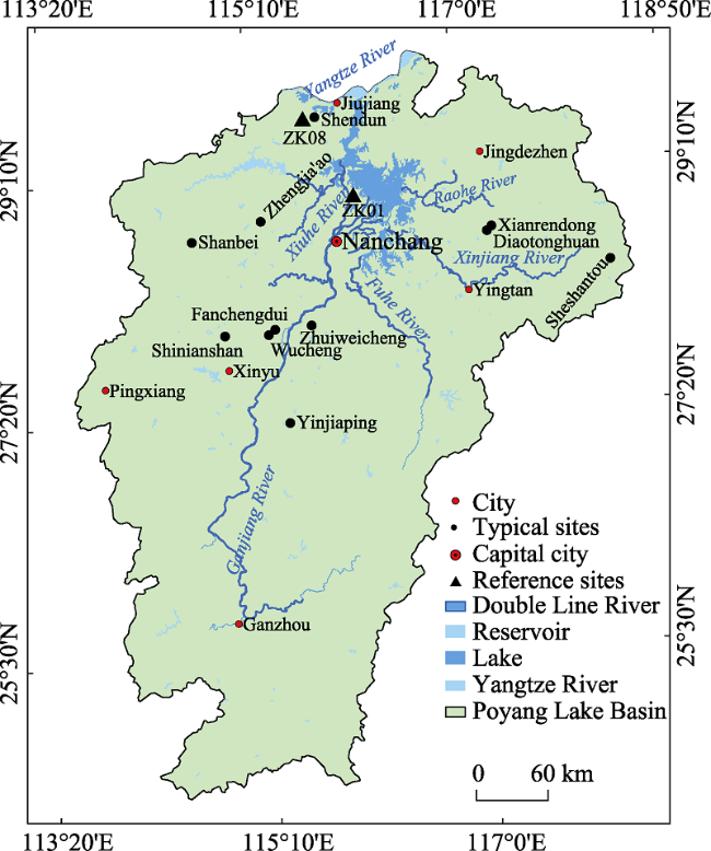
Figure 1 Sketch map of the location of the entire Poyang Lake Basin showing the water systems and major cities |
Table 1 Radiocarbon and thermoluminescence ages of archaeological sites used in this study from the Poyang Lake Basin |
 |
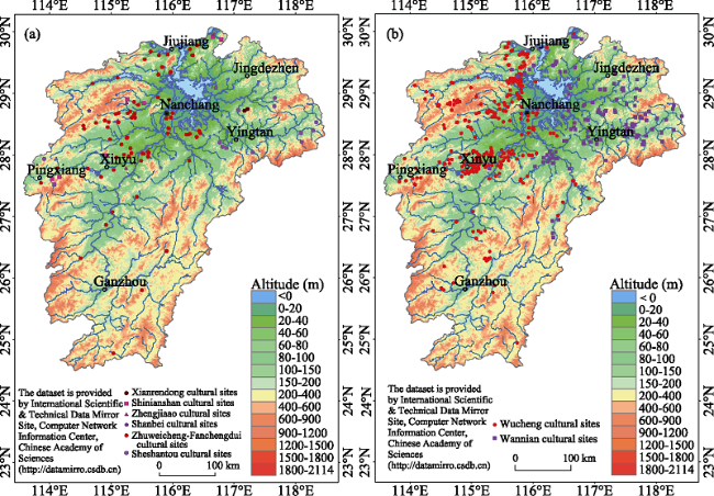
Figure 2 Archaeological sites of the Poyang Lake Basin: (a) in the Neolithic period (10.0-3.6 ka BP) and (b) in the Shang and Zhou dynasties (3.6-2.8 ka BP) |
Table 2 Altitude distribution of the Neolithic and Shang-Zhou cultural sites in the Poyang Lake Basin |
| Cultural type | Total | <50 m | 50-200 m | 200-500 m |
|---|---|---|---|---|
| Xianrendong | 2 | 0 | 2 | 0 |
| Shinianshan | 8 | 2 | 2 | 4 |
| Zhengjia’ao | 6 | 2 | 4 | 0 |
| Shanbei | 2 | 1 | 1 | 0 |
| Zhuweicheng-Fanchengdui | 78 | 35 | 41 | 2 |
| Sheshantou | 14 | 2 | 7 | 5 |
| Wucheng | 342 | 171 | 134 | 37 |
| Wannian | 145 | 57 | 78 | 10 |
Table 3 Production and living tools unearthed at typical sites in the Poyang Lake Basin (Guo and Li, 1963; Liu and Li, 1991; Li and Yu, 1976; Li et al., 1982; Zhou et al., 1993; Peng and Li, 1975; JPICRA, 1995; Peng et al., 1991) |
| Type | Shapes | Early Neolithic period | Middle Neolithic period | Late Neolithic period | Shang and Zhou dynasties |
|---|---|---|---|---|---|
| Agricultural tools | Celt | 1 | 4 | 1 | 21 |
| Tapered pike | 8 | 1 | 12 | ||
| Stepped adze | 2 | 90 | 15 | 13 | |
| Stone axe | 17 | 17 | 39 | ||
| Hoe | 2 | ||||
| Drill | 4 | 2 | 1 | ||
| Shovel | 2 | 24 | 2 | ||
| Knife | 19 | 11 | 70 | ||
| Millstone | 3 | ||||
| Dagger-axe | 33 | ||||
| Sickle | 7 | ||||
| Stone mould | 9 | ||||
| Plough | 2 | ||||
| Fishing and hunting tools | Osteotome | 1 | |||
| Fish fork | 1 | ||||
| Arrowhead | 3 | 83 | 48 | 138 | |
| Hole puncher | 40 | 19 | |||
| Burr | 6 | 183 | 10 | ||
| Spear | 4 | 37 | |||
| Net | 1 | 2 | 43 | ||
| Pie tools | 9 | ||||
| Life tools | Bone needle | 7 | |||
| Bone awl | 27 | ||||
| Frotton | 2 | 1 | |||
| Ding | 134 | 281 | 32 | ||
| Cup | 97 | 12 | 31 | ||
| Pot | 4 | 11 | 61 | ||
| Spinning wheel | 37 | 27 | 23 | ||
| Cooking tripod | 125 |
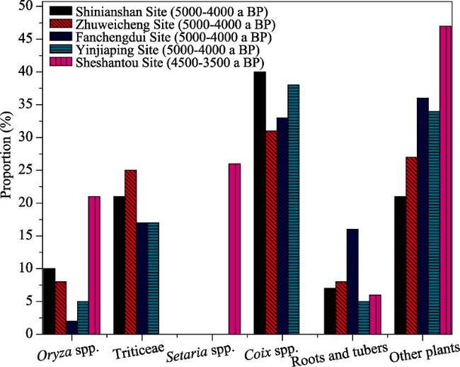
Figure 3 Proportion of each type of starch grain retrieved from the five Neolithic archaeological sites of the Poyang Lake Basin (Wan et al., 2012a, 2012b) |
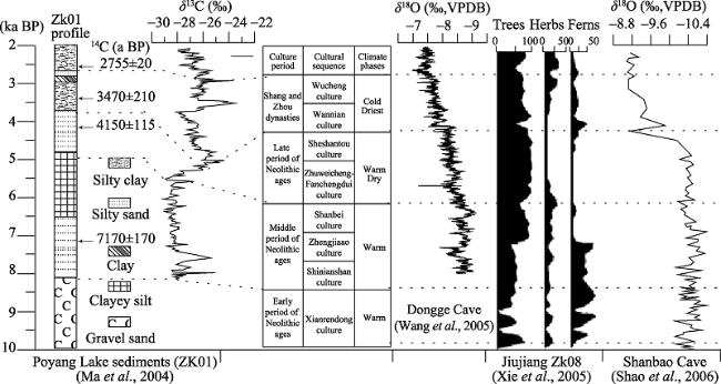
Figure 4 Correlation of prehistoric culture phases in the Poyang Lake Basin and the Holocene climate evolution inferred from δ13C record from Poyang Lake (ZK01), δ18O records of stalagmites from Dongge Cave, percentage of pollen (%) from Jiujiang (ZK08), Jiangxi Province and δ18O records of stalagmites from Shanbao Cave, Hubei Province. |
The authors have declared that no competing interests exist.
| 1 |
|
| 2 |
|
| 3 |
|
| 4 |
|
| 5 |
|
| 6 |
|
| 7 |
|
| 8 |
|
| 9 |
|
| 10 |
|
| 11 |
|
| 12 |
|
| 13 |
|
| 14 |
|
| 15 |
|
| 16 |
|
| 17 |
Institute of Archaeology, CASS, 1974. Radiocarbon dating report (3).Archaeology, (5): 333-338. (in Chinese)
|
| 18 |
Institute of Archaeology, CASS, 1977. Radiocarbon dating report (4).Archaeology, (3): 200-204. (in Chinese)
|
| 19 |
Institute of Archaeology, CASS, 1979. Radiocarbon dating report (6).Archaeology, (1): 89-96. (in Chinese)
|
| 20 |
Institute of Archaeology, CASS, 1991. Radiocarbon dating report (18).Archaeology, (7): 657-663. (in Chinese)
|
| 21 |
|
| 22 |
|
| 23 |
Jiangxi Provincial Institute of Cultural Relics and Archaeology (JPICRA),
|
| 24 |
Jiangxi Provincial Institute of Cultural Relics and Archaeology (JPICRA), Xiamen University, Guangfeng county Cultural Relic Administration, 1997. The third excavation of Sheshantou site in Guangfeng, Jiangxi Province.Relics From South, (1): 1-22. (in Chinese)
|
| 25 |
Jiangxi Provincial Institute of Cultural Relics and Archaeology (JPICRA), Xiamen University, Zhangshu Museum, 1995. The eighth excavation briefing of Wucheng Site in Zhangshu, Jiangxi.Relics From South, (1): 5-23. (in Chinese)
|
| 26 |
Jiangxi Provincial Institute of Cultural Relics and Archaeology (JPICRA), Jingan Museum, 1989. The briefing on tomb in Zhengjia’ao site.Southeast Culture, (Suppl.1): 1-13. (in Chinese)
|
| 27 |
|
| 28 |
|
| 29 |
|
| 30 |
|
| 31 |
|
| 32 |
|
| 33 |
|
| 34 |
|
| 35 |
|
| 36 |
|
| 37 |
|
| 38 |
|
| 39 |
|
| 40 |
|
| 41 |
|
| 42 |
|
| 43 |
|
| 44 |
|
| 45 |
|
| 46 |
|
| 47 |
|
| 48 |
|
| 49 |
|
| 50 |
|
| 51 |
|
| 52 |
|
| 53 |
|
| 54 |
|
| 55 |
|
| 56 |
|
| 57 |
|
| 58 |
|
| 59 |
|
| 60 |
|
| 61 |
|
| 62 |
|
| 63 |
|
| 64 |
|
| 65 |
|
| 66 |
|
| 67 |
|
| 68 |
|
| 69 |
|
| 70 |
|
| 71 |
|
| 72 |
|
| 73 |
|
| 74 |
|
| 75 |
|
| 76 |
|
| 77 |
|
| 78 |
|
| 79 |
|
| 80 |
|
| 81 |
|
| 82 |
|
| 83 |
|
| 84 |
|
| 85 |
|
| 86 |
|
| 87 |
|
| 88 |
|
/
| 〈 |
|
〉 |