Orginal Article

Land use transitions and their dynamic mechanism: The case of the Huang-Huai-Hai Plain

  • LIU Yongqiang , 1 ,
  • *LONG Hualou , 2
Expand
  • 1. Faculty of Architectural, Civil Engineering and Environment, Ningbo University, Ningbo 315211, Zhejiang, China
  • 2. Institute of Geographic Sciences and Natural Resources Research, CAS, Beijing 100101, China

Author: Liu Yongqiang (1982-), PhD and Lecturer, specialized in land use transition and environmental effects. E-mail:

*Corresponding author: Long Hualou (1971-), PhD and Professor, specialized in rural restructuring, urban-rural development and land use transition. E-mail:

Received date: 2016-01-08

  Accepted date: 2016-02-15

  Online published: 2016-05-25

Supported by

National Natural Science Foundation of China, No.41171149, No.41130748

The National Key Technology R&D Program of China, No.2014BAL01B05

Non-profit Industry Financial Program of Ministry of Land and Resources of China, No.201511004-3

Copyright

Journal of Geographical Sciences, All Rights Reserved

Abstract

Land use transition refers to changes in land use morphology, including dominant morphology and recessive morphology, of a particular region over a period of time driven by various factors. Recently, issues related to land use transition in China have attracted interest among a wide variety of researchers as well as government officials. This paper examines the patterns of land use transition and their dynamic mechanism in the Huang-Huai-Hai Plain during 2000-2010. First, the spatio-temporal patterns of land use transition, their characteristics and the laws governing them were analyzed. Second, based on the established conceptual framework for analyzing the dynamic mechanism of land use transition, a spatial econometric regression analysis method was used to analyze the dynamic mechanism of the five types of major land use transition in the Huang-Huai-Hai Plain at the county level. Land use pattern changes in the study area were characterized by an increase in construction land, water body and forested land, along with a decrease in farmland, unused land and grassland. The changes during 2000-2005 were much more significant than those during 2005-2010. In terms of factors affecting land use transitions, natural factors form the basis, and they have long-term effects. Socio-economic factors such as population and GDP, however, tend to determine the direction, structure, size and layout of land use transition over shorter time periods. Land law and policy factors play a mandatory guiding and restraining role in land use transitions, so as to improve the overall efficiency of land use. Land resource engineering is also an important tool to control land use transitions. In general, the five types of major land use transition were the result of the combined action of various physical, social and economic factors, of which traffic condition and location condition had the most significant effects, i.e. they were the common factors in all land use transitions. Understanding the spatio-temporal process of land use transitions and their dynamic mechanisms is an important foundation for utilizing land resources, protecting regional ecological environment and promoting sustainable regional socio-economic development.

Cite this article

LIU Yongqiang , *LONG Hualou . Land use transitions and their dynamic mechanism: The case of the Huang-Huai-Hai Plain[J]. Journal of Geographical Sciences, 2016 , 26(5) : 515 -530 . DOI: 10.1007/s11442-016-1283-2

1 Introduction

China is undergoing rapid socio-economic transformation development, at the same time the land use is experiencing a dramatic transition in both depth and breadth. Land use transition, as a new approach to the comprehensive study of land-use and land-cover (LULC) change refers to the change in land use morphology corresponding to the accompanying socio- economic development transition (Cai, 2001; Long, 2014a; Lambin and Meyfroidt, 2010). Land use morphology, which is the core content of land use transition, usually includes dominant morphology and recessive morphology. Dominant morphology means the quantity, structure and spatial pattern of the land, while recessive morphology, which is not easily detected compared to dominant morphology, includes the characteristics of quality, property rights and management mode, and input and output capacity of the land (Long, 2015). At present, the study of regional land use transitions is receiving increasing attention, and driving factors and their mechanism of land use change are the most important components for study (Kong, 2012; Lv et al., 2013; Liu et al., 2015a; Liu et al., 2015b), which can provide important references for the analysis of the mechanism of land use change (Li, 2002). Lambin and Meyfroidt (2010) considered that land use transition emphasizes the non-linear process of land use change and was closely related to the changes in other social and natural systems. They concluded, moreover, that land use transition was caused by negative feedback due to the depletion of key resources or by social and economic changes and innovations.
Previous studies on the dynamic mechanism of LULC change focused mainly on the area change in land use types and their driving factors in terms of economic, social and natural behavior to reveal the driving forces of LULC change in China (Li et al., 2001; Li et al., 2015). The results showed that large scale land use change was affected mainly by natural factors over long periods of time (Shao et al., 2007) and by social and economic factors over short periods (Long and Li, 2002; Xie and Li, 2008). Previous land use transition studies mainly considered the following three aspects: (1) the selection of driving forces of land use change initially focused on the physical attributes of land resources because the natural driving force data are easy to acquire, analyze and simulate, as a result, the understanding of land use transitions was unclear and not comprehensive; (2) a large number of studies focused on regions of fragile ecological environment, such as rapid economic development zones, rapid urban expansion areas, arid and semi-arid regions, but there was relatively little research into traditional agricultural areas; (3) with the development of “3S” technology and mathematical statistics, research methods of land use change have been continually improved, but the method of land use transitions itself has not matured. Research on land use transitions mainly used the most significant land use transition type as the research object; however, the less significant influence of other land use transitions of an area was often ignored (Liu and Zhu, 2010). This paper examines the spatio-temporal dynamic patterns of land use transitions at the county level in the Huang-Huai-Hai Plain, which is experiencing rapid urban-rural transformation development, using high-resolution Landsat TM (Thematic Mapper) data from 2000, 2005 and 2010, and uses a spatial econometric regression method to analyze the correlation between land use transitions and their driving forces.
The analysis of the dynamic mechanism of land use transitions in this paper focuses mainly on the change in land use dominant morphology, while the change in land use recessive morphology is analyzed qualitatively. This paper not only considers the increase or decrease in area of a certain type of land use transition, but also distinguishes its direction of flow, in or out, in order to carry out a more detailed analysis of the dynamic mechanism of land use transitions. Finally, by examining the spatio-temporal dynamic patterns of land use transitions, we hope to grasp the main characteristics of the five types of land use transition and to clarify the key factors driving the transition process and its mechanism of action.

2 Study area and data

2.1 Study area

The Huang-Huai-Hai Plain, the study area, is located south of the Yanshan Mountains, north of the Dabie Mountains, east of the Taihang Mountains and Funiu Mountains and west of the Bohai and Yellow seas, and includes the areas of five provinces and two municipalities, i.e. the whole of Shandong, most of Beijing, Tianjin, Hebei and Henan, and the northern parts of Anhui and Jiangsu, and covers an area of approximately 400 thousand km2. The Huang- Huai-Hai Plain has a population of at least 210 million (2009) and is generally representative of China’s plains as a whole. Its land area and population account for 31.7% and 52.6%, respectively, of the total plain area and plain population of China as a whole (Li et al., 2012; Liu et al., 2015b). The farmland of Huang-Huai-Hai Plain accounts for about one-sixth of China’s total and ranks first in terms of land reclamation rate, with 50 million ha sowing area, 33% of the country’s total, and producing 35%-40% and 60%-80% of China’s wheat and corn, respectively, which has played an important role in ensuring national food security (Kong et al., 2014; Li et al., 2012). Except for the Jiaodong Peninsula, the Huang-Huai-Hai Plain consists mainly of alluvial plain of flat terrain with deep soil that is suitable for farming (Guo et al., 1991), and the importance of grain production in the Huang-Huai-Hai Plain is increasing. A series of agriculture and food production support policies began in 2004 that promoted the grain yield in the Huang-Huai-Hai Plain significantly: the total grain output of approximately 136 million tons in 2008 increased by 27.61% compared to 2000. Unfortunately, the water shortage in the Huang-Huai-Hai Plain and the pollution that diffuses into it from various agricultural sources are becoming critical problems hindering regional development (Kong et al., 2014; Qiu, 2010).

2.2 Data sources

The vector data of LULC changes was obtained through detection analysis of historical Landsat TM (Thematic Mapper) satellite images taken in 2000, 2005 and 2010 by the China National Environmental Monitoring Center. Social and economic data was obtained from the China Statistical Yearbook (2001-2011), the China Population Statistics Yearbook (2001-2011), the China County (City) Social Economic Statistical Yearbook (2001-2011), the China Regional Economic Statistical Yearbook (2001-2011) and the Statistical Yearbook of Beijing, Tianjin, Hebei, Shandong, Henan, Anhui and Jiangsu. The data for provincial and county boundaries, government residents and roads and rivers were from the national fundamental geographic information system of the national database at the scale of 1:4000000 (http://nfgis.nsdi.gov.cn).

3 Methods

3.1 Land use transition analysis

Based on these Landsat TM data, LULC were classified into six types: farmland, water body, forested land, grassland, unused land and construction land used mainly for industry, mining and transportation as well as urban and rural settlements. Then, the changes among the six different LULC types were measured using ESRI’s ArcGIS spatial analyst module (Long et al., 2007).
Ploss(i),j = (Pj,i - Pi,j) / (Pi. - P.i)×100, ij (1)
Pgain(i),j = (Pi,j - Pj,i) / (Pi. - P.i)×100, ij (2)
where Ploss(i),j is the percentage taken by type j in the total “conversion loss” of category row i; Pgain(i),j is the percentage taken by type j in the total “conversion gain” of category row i; Pi,j and Pj,i are individual entries in the change matrix A.

3.2 Driving factor selection and parameterization

3.2.1 Driving factor selection of land use transition
Land use transition is a result of natural, social, economic, legal, institutional and engineering factors interacting with each other within a certain region. Therefore it is influenced not only by physical conditions but also by economic, technical, social and other factors (Long, 2015; Chen and Zhang, 2011). These were divided into the following driving factors: natural, social and economic, law and policy and land resource engineering (Figure 1).
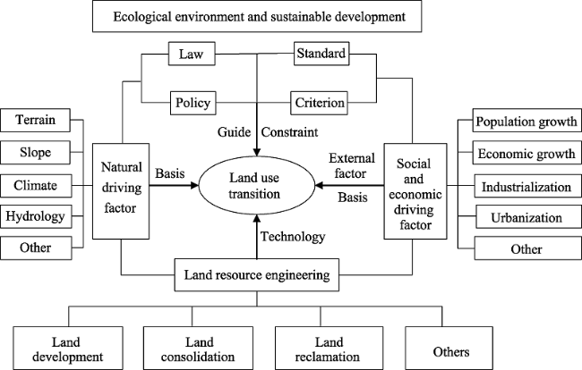
Figure 1 Conceptual framework for dynamic mechanism of land use transition
(1) Natural driving factor
From the perspective of spatial analysis, hydrological and geomorphological factors are usually chosen for driving force analysis at the small scale because they are different spatially and easy to express in a spatially quantitative way. Climatic factors can usually be applied at large or medium scales. Thus, climatic factors were selected as natural factors considering the large span of the Huang-Huai-Hai Plain from north to south. Accordingly, three kinds of natural driving factors, including terrain condition (elevation), hydrological condition (distance to the main river) and climatic condition (average annual rainfall) were chosen as natural driving factors.
(2) Social and economic driving factor
The effects of social and economic factors were obvious over a relatively short period of time, especially the effects of human activities (Long and Li, 2012). With better location conditions and higher urbanization level, the eastern coastal area of the Huang-Huai-Hai Plain had more significant impacts on land use transitions compared with the other regions. Considering the actual situation of the study area, the following factors were chosen, including total population, GDP per capita, rural per capita net income, urbanization rate, local financial expenditure and added value of primary industry, as the social and economic driving factor. In addition, the distance to provincial, municipal and county-level administrative centers were chosen as the characterization factor of location condition and the distance to the main road and railway as the characterization factor of traffic condition.
(3) Law and policy driving factor
Given the economic and ecological benefits and sustainable development deriving from land use transitions, the government needs to draft laws and policies to guide or constrain the latter, such as farmland protection, returning farmland to forests, water-saving agriculture, coastal zone management policy and so on. Studies have shown that land management policy had a more significant influence on land use change than any other driving factor, such as population or urbanization (Zhu et al., 2001).
(4) Land resource engineering driving factor
Land development, consolidation and reclamation all belong, in essence, to the category of land resource engineering and technology (Liu, 2015; Long, 2014b). Land resource engineering and technology had already provided a proven important support for the conversion of unused land (saline) to farmland in the Yellow River Delta of the Huang-Huai-Hai Plain, and they are becoming ever more important in regulating land use transition (Long, 2014b). Present day China is facing a more severely polluted atmosphere, along with water and soil pollution issues that compel us to seek new land resource engineering, technology and other related solutions.
3.2.2 Driving factor quantification and spatialization
This paper selected mainly terrain, hydrology and climate as natural factors and population and other external influences as socio-economic factors of land use transition in the Huang-Huai-Hai Plain. As some driving factors are impossible or difficult to quantify, such as law, policy, land resource engineering and technology, the analysis was carried out in a qualitative way. Specific steps are as follows:
(1) The terrain condition was characterized by elevation; the traffic condition was characterized by distance to the main road and the main railway; the hydrological condition was characterized by distance to the main river; and the local condition was characterized by distance to the county, municipal or provincial administrative center. First, the raster data was obtained by calculating the shortest distance from each pixel to the target source through the Euclidean Distance tool in ArcGIS. Second, the raster data of 90 m resolution DEM and the shortest distance obtained above were transferred into the point layer by the Raster to Point tool, so that each DEM and the shortest distance had elevation and distance information, respectively, associated with it. Third, an overlay analysis was carried out with the above point layers and the county (city)-level administrative region layer, so that each point in the data layer had both the elevation and administrative information associated with it, and the shortest distance data had the distance and administrative information. Finally, the attributes of the point layer thus obtained were exported.
(2) The climatic condition was characterized by mean annual rainfall which came from the original measured data of rainfall observation stations. First, the information for mean annual rainfall was imported into ArcGIS to obtain the point layer of rainfall observation stations. Second, Thiessen Polygons of each rainfall observation station were created using the Thiessen Polygons tools in ArcGIS. Third, overlay analysis with the county (city)-level administrative region layer was carried out so that each surface datum point had the rainfall and administrative information associated with it. Finally, the data for these two steps were exported and the elevation and the average distance to the target source were obtained using the Pivot Table in Microsoft Excel.
(3) Social and economic external driving factors were characterized by the total population, GDP per capita, rural per capita income, urbanization rate, local financial expenditure and the added value of primary industry. The method for quantification and spatialization of these factors was similar to that for internal factors, and the main work involved was the use of the Join tool in ArcGIS to import the changes in the above factors into the research unit (Figure 2).
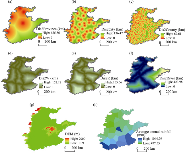
Figure 2 Quantitative spatial distribution of the driving factors of land use transition in the Huang-Huai-Hai Plain
Note: *: Significance at 10%; **: significance at 5%; ***: significance at 1%.
Dis2Province: distance to province-level administrative center; Dis2City: distance to city-level administrative center; Dis2County: distance to county-level administrative center; Dis2W: distance to main railway; Dis2R: distance to main road; Dis2River: distance to main river.

3.3 Spatial econometric regression analysis

Based on our land use transition analysis of the Huang-Huai-Hai Plain, spatial econometric regression models, including Ordinary Least Squares (OLS), Spatial Lag Model (SLM) and Spatial Error Model (SEM), were used to explain and reveal the inner correlationships between land use transitions and their driving factors among 15 driving factors and five categories of land use transition. The equations used in the three spatial econometric regression models are explained as follows:
The OLS model explains the relationship between a dependent variable and a collection of independent variables. The value of the dependent variable is defined as a linear combination of the independent variables plus an error term:
(3)
where yi is the dependent variable, xij are the independent variables, β0 is a constant term, βj are the regression coefficients, and εi are the normally distributed errors of prediction.
SLM assumes that the value of the dependent variable y in a site depends on the values of it in neighboring regions. It is thus a formulation of the idea of a spatial spillover. For example, the indicator values in one area will be affected by the surrounding areas. SLM is expressed as follows (Anselin et al., 2006):
y =ρWy + Xβ + ε(4)
where y is the variation of five categories of land use transition in the Huang-Huai-Hai Plain in each grid, X contains a set of explanatory variables for the regression relationship, with β as the corresponding regression coefficient, ρ is a spatial autoregressive coefficient indicating the extent to which variations in the observations of y are explained by the average of the neighboring observation values, ε is the model error term, and W is the spatial weight matrix.
Compared with SLM, the spatial dependence in the SEM enters through the errors rather than through the neighboring values of the dependent variable in the SLM (Anselin et al., 2006). SEM is specified as:
y = Xβ + ε(5)
ε= λWε + μ(6)
where y, X, β and W are the same as those in Eq. (4), λ is a spatial autoregressive coefficient, ε is the regression residual, and μ is the normally distributed random error.

4 Results

4.1 Land use transitions in the Huang-Huai-Hai Plain

In order to analyze the internal structural variability of LULC in the study area, a spatial overlay analysis was carried out based on the three interpreted land use maps. Three maps of land use changes during the periods 2000-2005, 2005-2010 and 2000-2010 were obtained (Figure 3) and a change matrix of each compared LULC type in 2000 and 2010 was obtained (Table 1). Land use changed significantly over the whole period 2000-2010 in the Huang-Huai-Hai Plain, which was characterized by decreases in farmland, unused land and grassland of 7.28%, 38.83% and 9.63%, respectively, and increases in construction land, water body and forested land of 45.36%, 27.09% and 5.88%, respectively. From the perspective of construction land change, built-up areas expanded very rapidly, from 4,423,668 ha in 2000 to 6,430,442 ha in 2010 (an increase of 2,006,774 ha), especially the expansions of Beijing, Tianjin, the northwest of Anhui Province and the north of Jiangsu Province which were most significant (Figure 3 and Table 1). In contrast, farmland decreased from 29,066,375 ha in 2000 to 26,949,362 ha in 2010 (Table 1). The distribution of increased construction land was coupled roughly with decreased farmland (Figure 3). In addition, it can be clearly seen that the changes in the first five years were much more significant than those in the following five years (Figure 3).
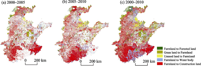
Figure 3 Change pattern of land use in the Huang-Huai-Hai Plain during 2000-2010
Table 1 Change matrix of each compared land use type in 2000 and 2010 in the Huang-Huai-Hai Plain (ha)
LULC type in 2000 LULC type in 2010
Farmland Forested land Grassland Water body Construction land Unused land Total
Farmland 25235074 320182 155761 502219 2806220 46919 29066375
Forested land 222594 1542866 99994 18297 68499 6538 1958788
Grassland 193778 147565 1358491 33527 76311 57686 1867359
Water body 200816 20237 25600 800867 68214 30148 1145882
Construction land 927849 36499 31946 77544 3341342 8487 4423668
Unused land 169250 6592 15783 23804 69856 63729 349013
Total 26949362 2073941 1687575 1456258 6430442 213506 38811084
In order to explore the internal conversion between different LULC types, which took place between 2000 and 2010, the change (decrease or increase) in a LULC type in 2010 relative to 2000 was treated as a result of several “loss or gain” conversions (Long et al., 2007). The expansion in construction land was caused mainly by a decrease in farmland, grassland and unused land, accounting for 90.84%, 2.47% and 2.26%, respectively (Table 2). The increase in forested land arose mainly from the transition from farmland, accounting for 60.29% of the total increased area due to the “returning farmland to forest” policy. Also, with the increase in population and food safety pressures, some beaches, as well as hillside land and other unused land, were reclaimed for farmland, accounting for 59.33% of the total change in unused land area. The increase in water body area came mainly from farmland transition, accounting for 76.63% of the total change in water body area.
Table 2 Internal conversions between land use types from 2000 to 2010 and the percentages taken by corresponding types in such loss or gain conversions
LULC type Loss or gain in 2010 (%) Type (1) Percent (%) Type
(2)
Percent (%) Type
(3)
Percent (%) Type
(4)
Percent (%) Type
(5)
Percent (%)
FL -7.28 CL 73.24 WB 13.11 FL 8.36 GL 4.07 UL 1.22
FR 5.88 FL 60.29 GL 27.79 CL 6.87 WB 3.81 UL 1.24
GL -9.63 FL 38.08 FR 29.00 CL 15.00 UL 11.34 WB 6.59
WB 27.09 FL 76.63 CL 11.83 GR 5.12 UL 3.63 FL 2.79
CL 45.36 FL 90.84 GL 2.47 UL 2.26 FL 2.22 WB 2.21
UL -38.83 FL 59.33 CL 24.49 WB 8.34 GL 5.53 FL 2.31

Note: FL: farmland; CL: construction land; FR: forested land; WB: water body; GL: grassland; UL: unused land.

From the viewpoint of spatial distribution (Figure 3), farmland that was transformed to construction land was widely distributed in the study area, especially in places with better location conditions. Farmland that was transformed to forested land occurred mainly in two kinds of places: one with mountains, hills and beaches, which are not suitable for growing plants, and the other with poor economic conditions. Farmland located in mountains, hills and beaches, especially in areas surrounding Beijing as well as central and southern Shandong Province with poor growing conditions, was gradually restored to forested land. In less developed regions, accompanying an increase in migrant workers, farmland was also gradually transformed to forested land. Such places are distributed mainly in the agricultural plain areas in Shandong, Henan and Hebei provinces. Farmland that was transformed to a water body occurred mainly in Jiangsu, Anhui, Tianjin and eastern Shandong provinces. The farmland here was changed mainly to aquaculture land and salt pans. Grassland that was transformed to farmland occurred mainly in hilly areas, especially in the west of Hebei Province and the central and southern areas of Shandong Province. Unused land that was transformed to construction land occurred mainly in the beach of the Yellow River and the coastal area of Tianjin.

4.2 Analysis of dynamic mechanism of land use transition

By using a spatial econometric regression analysis method derived from previous studies, a correlation analysis was performed between five main land use transition types and their driving factors in the Huang-Huai-Hai Plain (Anselin et al., 2006). First, the SHP format file and the attribute table file were prepared in ArcGIS10.3 and then the spatial weight matrix was generated in GeoDa software based on the above files. Second, choosing five land use transition types at the county level as the dependent variables and the distance to the main road, urbanization rate and other quantitative driving factors as the independent variables, then using the spatial weights file and selecting the regression model in GeoDa software, the quantitative relationship of land use transitions and their driving factors, including the direction and intensity with which the driving factors acted on land use transition, were analyzed. Finally, the efficiencies of the three regression models were compared according to the results of the analysis: if the Lagrange multiplier (error) was more significant than the Lagrange multiplier (lag), SLM was more efficient, otherwise SEM was more efficient; if both were not significant, the OLS model was more efficient. The results of the spatial dependence test showed that the Lagrange multiplier (error) was more significant than the Lagrange multiplier (lag), indicating that SLM was more efficient in our analysis (Table 3). Therefore, SLM was chosen to analyze the correlations between the five main land use transition types and their driving factors in this study. In terms of the fitting effect detection of the regression model, in addition to the fitting coefficient R2, there is also the log likelihood (LogL), the Akaike information criterion (AIC) and the Schwartz criterion (SC). The greater the LogL and the smaller the AIC and SC, the better the model fitting effect (Wu and Li, 2006). The results show that the fitting efficiency of SLM and SEM were better than that of OLS (Table 4).
Table 3 Results of spatial dependence test of land use transitions in the Huang-Huai-Hai Plain
Spatial dependence test FL to CL FL to FR FL to WB GL to FL UL to FL
Lagrange Multiplier (lag) 8.0688*** 5.1099** 24.4261*** 16.5650*** 2.9741*
Robust LM (lag) 9.4343*** 3.2083* 3.9966** 25.0583*** 15.7590***
Lagrange Multiplier (error) 2.4292 2.8466* 20.8213*** 4.0138** 0.4368
Robust LM (error) 3.7947* 0.9451 0.3918 12.5071*** 13.2217***

Note: FL: farmland; CL: construction land; FR: forested land; WB: water body; GL: grassland; UL: unused land. *: Significance at 10%; **: significance at 5%; ***: significance at 1%.

Table 4 Spatial regression analysis results of land use transitions and their driving factors in the Huang-Huai-Hai Plain
The spatial econometric regression analysis results at the county level showed that all the factors had significant effects on the five land use transitions, except for distance to the municipal administrative center and highway traffic mileage. Generally speaking, the five types of land use transition in the Huang-Huai-Hai Plain were the results of interaction of a variety of driving factors, such as natural factors, the social and economic factor, the law and policy factor and the land engineering factor, during which the transportation and location conditions were estimated to be the common driving factors as both had significant impacts on all types of land use transition. Moreover, the spatial econometric regression analysis results of farmland that was transformed to forested land and unused land that was transformed to farmland were not ideal because these two types of land use transition were distributed so centrally in the Huang-Huai-Hai Plain that they affected the results of the regression analysis; the other three types of land use transition were ideal in behavior. In addition, the distance to the county-level administrative center had a significant impact on the five land use transitions among all the driving factors although its direction of action and intensity were different . The other driving factors had no significant impacts on the five land use transition types. For example, law and policy driving factors only had a significant effect on the farmland that was transformed to forested land and water body, while the increase in population only had a significant effect on grassland and unused land that was transformed to farmland. The detailed analysis of the dynamic mechanism of the five types of land use transition is as follows:
(1) Farmland that was transformed to construction land was distributed widely in the Huang-Huai-Hai Plain. The transition from farmland to construction land had a significant correlation with the distance to the county-level administrative center and the main road at the 1% significant negative level, with the total population at the 5% significant positive level, with the average annual rainfall at the 10% significant positive level, and with DEM and the distance to the main river at the 10% significant negative level. Therefore, the main driving factors for farmland that was transformed into construction land were the distance to the county-level administrative center, the main road and the main river, the total population, the average annual rainfall and DEM, indicating that farmland that was transformed into construction land occurred mainly close to towns, main roads and rivers. Areas with dense population, greater average annual rainfall and flat terrain were also prone to trigger this type of land use transition. Among the above driving factors, the distance to the county-level administrative center and the main road had the most significant impact on farmland that was transformed into construction land, indicating that farmland with better location conditions was more likely to be transformed into construction land. For example, in rural China, farmers have traditionally liked to build their houses along the sides of roads, which has caused loss of farmland. In particular, the size of the total population had significant effects on farmland that was transformed into construction land but had no significant effects on the other four land use transition types. Therefore, with increase in population, farmland was rapidly transformed into construction land, especially if it had good location conditions.
(2) The transition from farmland to forested land had a significant correlation with rural per capita net income at the 1% significant positive level, with the urbanization rate at the 5% significant positive level, with the distance to the main road at the 5% significant negative level, and with the distance to the county-level administrative center at the 10% significant positive level. Therefore, the main driving factors of farmland that was transformed into forested land were rural per capita net income and urbanization rate and distance to the main road and the county-level administrative center. In particular, rural per capita net income and urbanization rate only had a significant effect on the transition of farmland to forested land but had no significant effect on the transition of the other four land use transition types. Through investigation in the rural areas of Shandong Province the number of migrant workers was found to be increasing, as this can bring them higher income in the form of wages. Against this background, an increasing number of farmers planted trees instead of food crops on their own farmland when they traveled to find work. In addition, the local government, driven by economic interests, did not actually oppose tree planting on farmland because it brought increased revenue (Zhao et al., 2012). This can explain why a large quantity of farmland was transformed into forested land at a rapid rate during 2000-2010. Farmland in ecologically fragile areas was easily affected by “returning farmland to forest”, “ecological forestry” and other related policies, such as “plain afforestation” in Beijing.
(3) The transition from farmland to water body involved mainly the transformation to aquaculture land. This had a significant correlation with the distance to the county-level administrative center, the added value of the primary industry and local financial expenditure at the 1% significant positive level, with the distance to main rivers at the 1% significant negative level, with average annual rainfall at the 5% significant positive level, and with DEM at the 10% significant negative level. Therefore, the main driving factors of farmland that was transformed into water body were the distance to the main river, the average annual rainfall, DEM, the distance to the county-level administrative center, the added value of the primary industry and local financial expenditure, indicating that farmland that was transformed into water body occurred mainly close to main rivers, far away from county administrative centers and in places with flat terrain and greater average annual rainfall which had good natural conditions for aquaculture. The changes in added value of the primary industry and local financial expenditure were the direct external driving forces for the transition from farmland into water body, but they had no significant effect on the transition of the other four land use transition types. This study in Shandong and Henan provinces also proved the results of the above analysis. In order to improve local fiscal revenue and agricultural production, these areas tried to increase the scale of aquaculture, so the area of the water body was enlarged. The essence of the transition from farmland to water body is the transition from the cultivation of traditional grain crops to aquaculture driven by profit and guided by local policies.
(4) The transition from grassland to farmland had a significant correlation with the distance to the county-level administrative center and DEM at the 1% significant negative level and with distance to the main railway and the main river at the 5% significant positive level. Therefore, the main driving factors of grassland that was transformed to construction land were the distance to the county-level administrative center, the main railway, the main river and DEM, indicating that grassland that was transformed into farmland occurred mainly far away from the county-level administrative center, the main railway and river, but was likely to occur in hilly areas with high terrain. As is well known, an increase in population and food pressures was the major reason for grassland to be transformed into farmland, but the analysis results showed that the main areas of grassland that were transformed into farmland were not the same as the areas with higher population density. Therefore, the total population factor did not show a significant correlation with the transition of grassland to farmland. Grassland that was transformed into farmland occurred mainly in hilly areas with ecologically fragile environments in the Huang-Huai-Hai Plain, thus these areas under great population and food pressures led to such a transition. It is a vicious circle that the expansion of farmland led to a reduction in grassland and the destruction of ecological systems in hilly areas. Thus, there needs to be a slow down or cessation in the trend of grassland being transformed into farmland in these areas in order to promote the recovery of vegetation and increase the trend in farmland being restored to forested land and grassland.
(5) The transition from unused land to farmland had a significant correlation with the distance to the main railway at the 1% significant positive level, with DEM at the 1% significant negative level, with the distance to the county-level administrative center at the 5% significant positive level, and with the distance to the provincial-level administrative center at the 5% significant negative level. Therefore, the main driving factors for the transformation of unused land to farmland were the distance to the county-level administrative center, the provincial-level administrative center, the main railway and DEM, indicating that unused land that was transformed to farmland occurred mainly in areas with low terrain, close to the provincial-level administrative center, far away from the county-level administrative center and the main railway. The results of the analysis showed that the main areas of unused land that were transformed into farmland were not the same as those areas with higher population density. Therefore, in the analysis of the driving mechanism of unused land that was transformed into farmland, the variation in total population did not show a significant correlation either. The Yellow River Delta in Shandong Province was the most typical area of unused land that was transformed into farmland in the Huang-Huai-Hai Plain and The Official Reply of the State Council on the Development Plan of the Yellow River Delta Efficient Ecological Economic Zone (State Council, 2009) pointed out that “constructing the Yellow River Delta into a nationally important reserve land resource development zone”. Based on the premise of not destroying the ecological system, it is right that the gradual trend for the transition of unused land to suitable farmland, which reflects the influence of national laws and their associated driving policy, be advanced (Wang et al., 2005). Moreover, the technology and expertise obtained from past wasteland and tideland reclamation could provide important technical support in this endeavor.

5 Discussion and conclusions

This paper investigated five types of land use transition in the Huang-Huai-Hai Plain based on Landsat TM image data for the years 2000, 2005 and 2010 using ArcGIS software and the established conceptual framework of the dynamic mechanism of land use transition. A spatial econometric regression analysis method was used to analyze the dynamic mechanism of these five types of major land use transition. The results indicated that land use patterns in this region changed significantly and were characterized by an increase in construction land, water body and forested land, along with a decrease in farmland, unused land and grassland during the study period. The changes during the period 2000-2005 were much more significant than those during 2005-2010. In the first five years, land use transition was characterized mainly by farmland and unused land that was transformed into construction land and farmland that was transformed into forested land, grassland and water body. In the following five years, land use transition was characterized mainly by farmland that was transformed into construction land and water body as well as forested land and grassland and unused land that were transformed into farmland.
Land use transition is a result of natural, social, economic, legal, institutional and engineering factors interacting with each other in a specific region. On this basis, the conceptual framework of the dynamic mechanism of land use transition was established, which includes a natural driving factor, a social and economic driving factor, a law and policy driving factor and a land engineering driving factor. Then, based on the county-level spatial econometric regression analysis, it was found that traffic condition and location condition, which both belong to the social and economic driving factor, had significant effects on all five types of land use transition, and so they can be regarded as the common driving factors of land use transition in the Huang-Huai-Hai Plain. In addition, the dynamic mechanisms of the five types of land use transition are different in terms of both the direction and intensity with which the driving factors acted on land use transition.
Land use transition in the Huang-Huai-Hai Plain is based on regional, natural and geographical conditions and is a comprehensive result of economic development, population flow, policy control and the ideas and customs of farmers all interacting with each other. Local governments at different levels should not only consider all the major driving factors of land use transition, the law of regional differentiation and social and economic development, but they also need to fully consider the suitability and degree of difficulty of different types of land use transition. Only in this way can land consolidation, development, reclamation and other land resource engineering be advanced more scientifically. On this premise, land use transition would take place in line with the appropriate regional, economic and social development stage of each area. In future, more attention should be paid to the study of land recessive morphology changes by focusing on the small spatial scale in order to promote land resource management transition (Long, 2015), e.g., transforming pure quantitative management to quantitative, qualitative and ecologically comprehensive management and optimizing the allocation and effective use of land resources.

The authors have declared that no competing interests exist.

1
Anselin L, Syabri I, Kho Y, 2006. GeoDa: An introduction to spatial data analysis.Geographical Analysis, 38(1): 5-22.The development of specialized software for spatial data analysis has seen rapid growth since the lack of such tools was lamented in the late 1980s by Haining (1989) and cited as a major impediment to

DOI

2
Cai Y, 2001. A study on land use/cover change: The need for a new integrated approach.Geographical Research, 20(6): 645-652. (in Chinese)Land cover changes are not simple processes. There are complex simultaneous patterns of land-cover change, ranging from modifications in land cover to conversions and maintenance. There is a functional complexity within types of land-cover change, and a structural complexity between types of land-cover change, both in terms of spatial arrangements and temporal patterns of change. Land-cover change needs to be measured in its complexity to fully understand it. It is important to differentiate between land cover and land use when measuring patterns of changes. Land-use/land-cover change is a kind of extremely complex phenomenon. For all researchers involving in the study to avoid the unilateralism like blind-person touching elephant, they should search a new synthesis of studies. Therefore, the traditional approach of land use study is not effective and new topics are needed to be further found. A generalized and comprehensive understanding is required for the drivers of land-use change. We need a network of case studies that represents the spatial heterogeneity of the region and a multi-level approach that allows for a linkage between regional and local scale land-cover dynamics. Case study comparison is a major tool to derive generalizations of land-use/land-cover change research. We should develop new methods in mathematical modeling, descriptive models, empirical study, systematic case study and mechanism study. Linking house-hold-level information to remote sensing data is becoming a major tool to increase our understanding of land-use dynamics. The drivers of LUCC are always present but interact differently according to the temporal and spatial dynamics of the situation. A thorough understanding and modeling of these complex interactions is a prerequisite to generate realistic projections of land-cover change. The more important hypotheses for LUCC are those that frame the integration and synthesis of the science.

DOI

3
Chen B, Zhang F, 2011. Trend and priority areas in land use research of China.Geographical Research, 30(1): 1-9. (in Chinese)Land use research has enhanced the academic status and the academic impact with the close combination of land management practices since the beginning of the 21st century.It has made great progress in the investigation and monitoring,comprehensive property evaluation,planning and design,change and mechanisms,engineering and technology of land use.In the analysis of development trend,the paper proposes some suggestions,namely,strengthening the basic theory,paying attention to the methods system,widening perspectives and deepening the connotation,and strengthening aggregation and integration capabilities in land use research.In accordance with national demands for land use of participation in the economic macro-control,construction of resource-saving and environment-friendly society,as well as guarantee of food safety,the paper describes four priority areas on land use study. The study of land use change and mechanisms should focus on natural,economic and social factors on the coupling,as well as economic,social,technological development on the transformation of land use.The analysis of environmental impact and effects on land use should put emphasis on the interaction between economic and social development impact and the effects from land-use quantity,quality and ecological factors.The investigation and monitoring of land use should be aided with digital survey and monitoring technology and methodology.The development and decision-making of land use information should be combined with the macro-economic decision model.

DOI

4
Guo H, Xu Y, Yao J, 1991. Rural Geography in the Huang-Huai-Hai Region. Shijiazhuang: Hebei Science and Technology Press. (in Chinese)

5
Kong X, 2012. The Influence of Land Use Transition of Regional Peasant Household on Farmland Quality. Beijing: Science Press. (in Chinese)

6
Kong X B, Lai R, Li B Get al., 2014. Fertilizer intensification and its impacts in China’s HHH plains.Advances in Agronomy, 125: 135-169.

7
Lambin E F, Meyfroidt P, 2010. Land use transitions: Socio-ecological feedback versus socio-economic change.Land Use Policy, 27: 108-118.lt;h2 class="secHeading" id="section_abstract">Abstract</h2><p id="">The concept of land use transition highlights that land use change is non-linear and is associated with other societal and biophysical system changes. A transition in land use is not a fixed pattern, nor is it deterministic. Land use transitions can be caused by negative socio-ecological feedbacks that arise from a depletion of key resources or from socio-economic change and innovation that take place rather independently from the ecological system. Here, we explore whether the sources of land use transitions are mostly endogenous socio-ecological forces or exogenous socio-economic factors. We first review a few generic pathways of forest transition as identified in national case studies, and evaluate the varying ecological quality of expanding forests associated with these pathways. We then discuss possible explanatory frameworks of land use transitions. We use the case of the recent forest transition in Vietnam as an illustration. Socio-ecological feedbacks seem to better explain a slowing down of deforestation and stabilization of forest cover, while exogenous socio-economic factors better account for reforestation. We conclude by discussing the prospects of accelerating land use transitions in tropical forest countries.</p>

DOI

8
Li P, Li X, Liu X, 2001. Macro-analysis on the driving forces of the land use change in China.Geographical Research, 20(2): 129-138. (in Chinese)Land use is one complex system, which is affected by many factors, including both socio economic elements and natural resources and environment This paper firstly established a framework for macro analysis on the driving forces of land use change in China, in which economic welfare, environmental welfare, the need for food security and the advancement of science and technology are the main forces contributing to the land use changes Then the paper analyzed the basic contradictions in the land use change in recent years on the basis of current situation of land use and economic development in China In the third section, according to the analytical framework established firstly and the basic contradictions in the land use change, and on the basis of the land use data and other related socio economic documents in recent years, this paper analyzed and computed the indexes of the driving forces of the land use change and represented their spatial distribution in China By the distribution of these driving forces, the whole China can be seen as three distinct sub areas: Tibet southwest sub area, central northwest sub area and east sub area, each of which takes on different features in respect of the driving forces of land use changes As indicated in this paper, the economic welfare is the fundamental impetus to the land use changes, and the environmental welfare and the need for food security are also important factors in China The future land use change is ultimately decided by the performance of these factors and their interactions

DOI

9
Li T, Long H, Liu Yet al., 2015. Multi-scale analysis of rural housing land transition under China’s rapid urbanization: The case of Bohai Rim.Habitat International, 48: 227-238.With the rural-to-urban migration under China's rapid urbanization, the Bohai Rim of China experienced dramatic rural housing land transition (RHLT) in the last decade, especially in terms of per capita rural housing land (PRHL). The objectives of this study are to (i) analyze the spatio-temporal patterns of RHLT, and (ii) detect the underlying driving forces and mechanism of RHLT in Bohai Rim during 2000&ndash;2010. To achieve these goals, we collected and rasterized high resolution Landsat TM data, socio-economic and physical environmental data for the Bohai Rim. Spatial econometric regression models at both grid scale and county scale were developed to examine the driving forces of RHLT in Bohai Rim. The results indicated that the distribution of rural housing land was characterized by vertical zonality, i.e., the proportion of rural housing land decreased gradually with the increase of elevation, and was more sensitive to slope than to elevation. The results of hot spots analysis showed that the spatial mismatch of rural housing land change and rural population migration made the regional differences of RHLT more remarkable, based on which four rural housing land consolidatio

DOI

10
Li X, 2002. Explanation of land use change.Progress in Geography, 21(3): 195-203. (in Chinese)The most fundamental obstacle to progress in the understanding and prediction of human impacts on environmental changes lies in the lack of a comprehensive and integrative theory of human land relationships. The recent growth of research into land use and land cover change has revealed the inadequacy of current theories. On the other hand, specific land use issues have been effectively addressed by different disciplines, such as economic geography, regional and urban economics, and law. This paper reviews the land use theories and system models that indirectly or exclusively touch the dynamics of land use in time and space. A comprehensive framework for the explanation of land use changes is proposed. The author argues that a multi disciplinary approach into land use change studies, as an alternative to a new integrative theory of human land relationships, help the establishment of a holistic understanding of the process. Analyses of land user&rsquo;s economic behavior and land manager&rsquo;s institutional behavior constitute the major components of the framework. Thunen and Alonso&rsquo;s bid rent curve approach provides a foundation for the former analysis, while Platt&rsquo;s interaction loop among land use system, environment system and institution system provides theoretical base for the latter. With the bid rent curve approach, understanding of land use change lies in an analysis of conditions for change of transference margins in the micro perspective and an analysis of conditions for change of the slope of bid rent curve in the macro perspective. All these changes will break the spatial equilibrium of land use and then constitute the driving forces of land use change. With Platt&rsquo;s interaction loop approach, attention should be paid to strength of the signals from both the nature side and the society side. The author claims that changes on land use policies in China after the &rsquo;who will feed China&rsquo; debate in the mid 1990s, the large flooding on the lower reaches of the Yangtze River and the strong dust storms in North China in early 2000, reflect the impact of strong signals. The paper also discusses the intrinsic properties of land that make unique of the dynamic mechanism of land use. Of these properties, multiple suitability, constraint in area and quality, and immovability are imperative to land use changes. Trend in land use specialization and the implicative shrinking of land&rsquo;s natural functions is a cue for the understanding of land use changes, and that of the overall human environment relationships as well.

DOI

11
Li Y, Liu Y, Long H, 2011. Study on the pattern and types of rural development in the Huang-Huai-Hai region.Geographical Research, 30(9): 1637-1647. (in Chinese)China's agricultural and rural development has come into a new period of transformation since 2004,and this may provide new chances for rural development in less developed traditional agricultural areas.As such,geographical comprehensive studies on rural development in these areas are urgently needed.The Huang-Huai-Hai region,a representative of China's traditional agricultural areas,is an important hinterland of Bohai Economic Rim and a major base of China's grain and cotton production.The middle-and low-yield farmland improvement and agricultural comprehensive development initiated in the early 1970s had significantly accelerated the agricultural development in this region.Agricultural production function of this region has been further strengthened.However,rural development was still at a low level.This paper established an indicator system for assessing integrated level and spatial pattern of rural development in this region in 2000 and 2008 at county level.Furthermore,rural development types at county level were classified based on five indices including integrated rural development index,per capita output of major agricultural product,the proportion of agricultural labor in total rural labor,scale industrial output value per capita and the proportion of tertiary industry in GDP using self-organizing feature maps(SOFM) network modeling.The results showed:(1) rural development of the Huang-Huai-Hai region in 2008 has been significantly improved compared with 2000,as evidenced by the integrated rural development index showing an annual increase of 7.71%;(2) however,regional differences of integrated rural development index is still large and its spatial pattern showed no significant change during the study period;(3) per capita grain output and per capita output of major agricultural product have significant negative correlation with integrated rural development index and other selected rural development indictors;(4) according to cluster analysis supported by SOFM network,eight rural development types were divided.In urban-rural transformation,governments at all levels should identify limiting factors based on local conditions of various rural development types.Besides,more attention should be paid to the negative correlation between bulk agricultural commodities production and integrated rural development.

DOI

12
Li Y, Liu Y, Long H, 2012. Characteristics and mechanism of village transformation development in typical regions of the Huang-Huai-Hai Plain. Acta Geographica Sinica, 67(6): 771-782. (in Chinese)China's agriculture and rural development have made great achievements since the reform and open-door policy was initiated. However, it can be seen clearly that agricultural foundation of China is still weak, rural development is still lagging behind, and the increase of farmers' incomes is still unstable. Village is definitely the main battlefield of solving problems related to farmers, agriculture and rural areas (so called "San Nong Wen Ti" in Chinese) and building new countryside, so it is of great theoretical and practical value to carry out studies on the evolutionary process and dynamic mechanism of village development. This study aims to explore the evolutionary processes, common features and general mechanism of village development in the Huang-Huai-Hai Plain, a representative of China's traditional agricultural regions, based on systematic analysis of development history and mechanism of five villages in three counties with different types of rural development. The main contents and results were summed up as follows: (1) Factors that influence village development. Geographical location, economic basis, resource and environment endowments, social capital and human capital are internal influencing factors; macroeconomic environment, institutional arrangement, market demand, professional techniques and government support are external ones; accidental factors from interior or exterior village may catalyze, lubricate or block village development. (2) Common features of village development. Grassroots participation is the core concept and basic principles that should be adhered to during the course of village development; the integration of internal and external motivation is the objective needs of village development and rural elites play an important role during the process, in particular, they are usually the key actors of motivating and integrating the desire of internal and external participants; to seize high value-added part of value chain is the strategic orientation of village industrial development; innovation is one of the most important engines driving village development; strategy, planning and executive force are also vital supports for village development; and overall, village development is a dynamic process of self-organizing and network forming. (3) General mechanism of village development. Local villagers are the main body of village development, and rural elites are the core element. Based on a systematic insight into the local resources endowment, development willingness, market demand, government's policy orientation, external experiences and so on, the rural elites exert themselves to stimulate the internal motivation and integrate the external motivation, and then these actors jointly build the collaborative organization, learn for innovation, formulate development strategy, carry out division of labor and participate in market competition, so as to accelerate the optimization of local village's bio-physical structure, techno-economic structure and institutional-social structure, and as such the village may realize a transitional development. These findings may contribute to the theorizing of village transformation development in contemporary China and benefit local democratic decision-making, land consolidation and the development of high-benefit industrial agriculture in the Huang-Huai-Hai Plain.

DOI

13
Liu R, Zhu D, 2010. Methods for detecting land use changes based on the land use transition matrix.Resources Science, 32(8): 1544-1550. (in Chinese)Land use change is a key component for global environment change, and also a representation of the impact of human activities on the environment. The cross-tabulation matrix is a fundamental tool in analyses of land use change, but many studies seem to be short of analyzing the matrix in terms of its various components, failing to obtain as much insight as possible concerning the potential processes that determine a general pattern of land use change. This paper aims to use the cross-tabulation matrix to assess the total land use change on the basis of the net change and transfer change. The relative differences between the observed transition and expected transition, which were generated by random transitions, can be used to extract systematic inter-category transitions. An example of changes among five land use categories in Linyi County in Shandong Province illustrated the effectiveness of the suggested method. The amount of total change for cropland was found largest, followed by forest land, unused land, construction land and others. The change in cropland was nearly a pure swap-type of change. In contrast, the unused land indicated no swap change but net change. Changes in others consisted of both swap and net change. The most prominent transition was the conversion from cropland to forest, accounting for 2.63% of the landscape, followed by the conversion from unused land to cropland, and cropland to construction land. If the gains occurred at random categories, it replaced the unused land at a rate eight times of the expected rate. The large conversion from cropland to forest could be attributed to the largest cropland in all categories, since the quantity of the conversion was almost equivalent to what would be expected from a random process. If the processes of loss occurred at random categories and the other land lost, forest tended to replace it at a rate exceeding two times of the expected rate. A relatively large conversion from cropland to forest could be as a result of the smallest area of forest in all land use categories, since the quantity of the conversion was larger than what would be expected from a random process. It was concluded that these methods can facilitate detection of the strongest signals from systematic land use transitions, which would be greatly helpful for analyses and modeling of land use change.

14
Liu Y, 2015. Integrated land research and land resources engineering.Resources Science, 37(1): 1-8. (in Chinese)lt;p>Land is the solid bases for human life and development and sustainable land use is very important to the socioeconomic development of human society. Promoting comprehensive theoretical and engineering technological innovation for land resources is an important frontier in development transformation, eco-civilization construction, human-land relationship coordination and people's livelihood-land protection in China. Because of rapid industrialization and urbanization, land use, exploitation and management in China face serious problems. The current knowledge, study direction and technologies regarding land resources cannot support China's key land use problems and it is necessary to intensify the study of land resource engineering and application. Here, we discuss the main themes and content around land resource engineering, empirically analyze typical engineering cases, and investigate areal modes and the impact of land resource engineering studies. We found that land resource engineering indicates comprehensive engineering and the application of investigation assessment, planning design, exploitation consolidation and protection utilization of land resources usable for agriculture, forestry, husbandry and other industries. Land resource engineering normally includes engineering technologies for land investigation, assessment, planning, design, exploitation, consolidation, protection and utilization. It is necessary to further develop land resource engineering in China. For example, more attention should be paid to theoretical systems, regional diagnosis, technological methodology, standards, functioning modes, performance assessment and mechanisms. Particularly, the cross-integration of various subjects, public participation, absorbing local knowledge, innovating key engineering technologies, establishing multi-participants networks, and innovating mechanisms of land resources engineering should be intensified when there are problems such as land shortage, degradation and inefficiency.</p>

15
Liu Y, Liao L, Long Het al., 2015a. Effects of land use transitions on ecosystem services value: A case study of Hunan province.Geographical Research, 34(4): 691-700. (in Chinese)With the rapid development of Chinese economy, many negative effects of land use transitions under the pressure of rapid urbanization on local ecological system and environment have occurred. This paper examines the dynamic patterns of land use transitions in Hunan province, using high-resolution Landsat TM (Thematic Mapper) data in 1995, 2000, 2005 and 2010, and socio-economic data from both research institutes and government departments, and assesses the changes of ecosystem services value (ESV) by drawing a connection between the observed land use dynamics and the evaluation of ESV, based on the latest research of Costanza et al. and some revisions adapted to the situation of China. The outcomes indicated that, during the period from 1995 to 2010, the land use changed significantly, characterized by the increase of construction land and the decrease of cultivated land and grassland; ESV of the study area decreased by 0.42%, from 880.78 to 877.09 billion RMB, due to the losses of large quantities of ecological land to construction land. Then, some of the major implications for improving the land use of Hunan province were discussed. The authors argue that it is fundamental to meet the demand of construction land for socio-economic development, meanwhile, to protect regional ecosystem services function and maintain its stability; only in this way Hunan province may realize the sustainable use of ecological resources in the process of rapid urbanization, as well as the integration of economic, social and ecological benefits.

16
Liu Y, Long H, Li Tet al., 2015b. Land use transitions and their effects on water environment in Huang-Huai-Hai Plain, China.Land Use Policy, 47: 293-301.This paper analyzes the spatio-temporal dynamic patterns of land use in Huang-Huai-Hai Plain, one of the China's most important grain production bases experiencing rapid urban ural transformation development, using high-resolution Landsat TM (Thematic Mapper) data and series data of water environmental quality monitoring in 2000 and 2010, and related socio-economic data from government departments. After assessing the change of water environmental quality of Huang-Huai-Hai Plain during 2000鈥2010, three spatial econometric regression models including Spatial Lag Model (SLM), Spatial Error Model (SEM) and ordinary least squares (OLS) are used to explore the correlationships between land use transitions and water environmental changes. The outcomes indicated that, during the research period, land use pattern changes in the study area were characterized by the loss of large quantities of farmland and the increase of construction land and water body. On the whole, the water environment in the study area was obviously improved, but there also existed partial deterioration as evidenced by the increase of monitoring sections with water environmental quality below Class V. In general, the increases of grassland, forested land and water body have positive effects on water environmental quality while farmland and construction land have negative effects on that. The authors argue that construction land use and farmland use have almost equal negative effects on water environmental quality, and managing agricultural non-point source pollution is pivotal to improve local water environmental quality. Finally, some of the major implications for managing the land and water resources in the plain areas of China as well as other developing countries undergoing rapid urban鈥搑ural transformation development are discussed in the aspects of ecological farming practices, rural construction land management, land use planning and urban planning.

DOI

17
Long H, 2014a. Land use policy in China: Introduction.Land Use Policy, 40: 1-5.This themed issue of Land Use Policy builds mainly on papers presented at an international conference on 17Land Use Issues and Policy in China under Rapid Rural and Urban Transformation17, convened by the Chinese Academy of Sciences in Beijing, China, in October 2012. The conference set out to share and promote new scientific findings from a range of disciplines that advance research on land use policy in China. The contributions to this themed issue provide conceptual17theoretical and empirical takes on the topic, around four main areas of interest to both researchers and policymakers: nation-wide land use issues, the Sloping Land Conversion Program, land engineering and land use, and land use transitions. Various land use issues have been associated with rapid urban17rural transformations in China, giving rise to formulation of new policies directly affecting land use. However, these have contributed to new land use problems due to the nature of the policies and the difficulties in policy implementation constrained by the special 17dual-track17 structure of urban17rural development in China. In view of this, this themed edition makes a compelling call for more systematic research into the making and implementation of China's land use policy. It also emphasizes the challenges for further research on land use policy in China.

DOI

18
Long H, 2014b. Land consolidation: An indispensable way of spatial restructuring in rural China.Journal of Geographical Sciences, 24(2): 211-225.lt;p>The implementation of new type industrialization and urbanization and agricultural modernization strategies lacks of a major hand grip and spatial supporting platform,due to long-term existed &quot;dual-track&quot; structure of rural-urban development in China as well as unstable rural development institution and mechanism. It is necessary to restructure rural production,living and ecological space by carrying out land consolidation,so as to establish a new platform for building new countryside and realizing urban-rural integration development in China. This paper develops the concept and connotation of rural spatial restructuring. Basing on the effects analysis of industrialization and urbanization on rural production,living and ecological space,the mechanism of pushing forward rural spatial restructuring by carrying out land consolidation is probed. A conceptualization of the models of rural production,living and ecological spatial restructuring is analyzed combining with agricultural land consolidation,hollowed villages consolidation and industrial and mining land consolidation. Finally,the author argues that a &quot;bottom-up&quot; restructuring strategy accompanied by a few &quot;top-down&quot; elements is helpful for smoothly pushing forward rural spatial restructuring in China. In addition,the optimization and restructuring of rural production,living and ecological space will rely on the innovations of regional engineering technology,policy and mechanism,and mode of rural land consolidation,and more attentions should be paid to rural space,the foundation base and platform for realizing urban-rural integration development.</p>

DOI

19
Long H, 2015. Land use transition and land management.Geographical Research, 34(9): 1607-1618. (in Chinese)With the introduction of land use transition to the academic circle of China since the turn of the new millennium, related researches combining with the characteristics of China's socio-economic development have been carried out extensively. Recently, issues related to land use transition in China have attracted interest among a wide variety of researchers as well as the government officials. Land use transition refers to the changes in land use morphology including dominant morphology and recessive morphology of a certain region over a certain period of time driven by socio-economic change and innovation. In general, dominant land use morphology refers to the quantity, structure and spatial pattern of land use, and recessive land use morphology includes land use features in terms of aspects of quality, price, property rights, management mode, input and productive ability, and function. This paper puts forward the theoretical model of regional land use transition as the following: with the socio-economic development, the transformations between different land use types during a certain period of time arise the changes of regional land use morphology pattern from strong conflict to weak conflict, i.e., coordination, which enable a new balance between different land use morphology patterns reflecting the development trend of different economic departments, and then realize the transformation of urban-rural land use system from quantitative change to qualitative change. Then, the mechanism of mutual feedback between land use transition and land management was probed based on a three-fold framework of natural system-economic system-managerial institution system. Generally, land use transition is affected by land management via economic measures, land resources engineering, policy and institution. Land use transition can also contribute to the adjustment of land management measures via socio-ecological feedback. Therefore, policy-makers need to adjust their land management policies taking into account the continuous change of land use morphology and different phases of regional land use transition. Under the background of urban-rural transformation development, the researches of land use transition and land management may focus on how to measure the transitions of land use dominant morphology and recessive morphology and the subsequent transition of the function of land use system, how to measure the socio-economic and environmental effects of land use transitions, how to refine the popular model of regional land use transition, and how to adjust land use transition via socio-economic and engineering measurements. Finally, the author argues that more attentions need to be paid to the recessive morphology of land use, the change of which is the key to policy and institution innovation and improving land management.

20
Long H, Li T, 2012. The coupling characteristics and mechanism of farmland and rural housing land transition in China.Journal of Geographical Sciences, 22(3): 548-562.Abstract<br/><p class="a-plus-plus">Land use transition refers to the changes in land use morphology (both dominant morphology and recessive morphology) of a certain region over a certain period of time driven by socio-economic change and innovation, and it usually corresponds to the transition of socio-economic development phase. In China, farmland and rural housing land are the two major sources of land use transition. This paper analyzes the spatio-temporal coupling characteristics of farmland and rural housing land transition in China, using high-resolution Landsat TM (Thematic Mapper) data in 2000 and 2008, and the data from the Ministry of Land and Resources of China. The outcomes indicated that: (1) during 2000–2008, the correlation coefficient of farmland vs. rural housing land change is −0.921, and it shows that the change pattern of farmland and rural housing land is uncoordinated; (2) the result of Spearman rank correlation analysis shows that rural housing land change has played a major role in the mutual transformation of farmland and rural housing land; and (3) it shows a high-degree spatial coupling between farmland and rural housing land change in southeast China during 2000–2008. In general, farmland and rural housing land transition in China is driven by socio-economic, bio-physical and managerial three-dimensional driving factors through the interactions among rural population, farmland and rural housing land. However, the spatio-temporal coupling phenomenon and mechanism of farmland and rural housing land transition in China are largely due to the “dual-track” structure of rural-urban development.</p><br/>

DOI

21
Long H, Li X, 2002. Analysis on regional land use transition: A case study in a transect of the Yangtze River.Journal of Natural Resources, 17(2): 144-149. (in Chinese)Regional land use morphology is the overall pattern of actual land cover in a region at a given time,comprising the main types of land use.It can be represented either(a)spatially,by a map of a region divided into cropland,pasture land,forestland,urban-industrial land and wasteland,etc.,or(b)non-spatially by the shares of regional territory under each land use type.Furthermore,it can change with the changes of the socio-eco nomic development phase that the region is in.Regional land use transition refers to the changes in regional land use morphology over time,and it usually corresponds to the transition of socioeconomic development phase.Transect of the Yangtze River(TYR),with obvious grads both in the change of physical envi-ronmental factors and in the level of socioeconomic development,was taken as study area in this paper.According to land use changes and pattern,five regional types of land use changes in TYR are classified.Land use changes in several years or decades are mainly driven by socioeconomic factors and restricted by physical factors,and they can be mainly reflected by the changes of cul-tivated land and built-up land,which are tightly interrelated with human productive activities.The changes of farmland and settlements in TYR are examined.Analysis of concerned data showed that the rural housing transition in TYR could reflect its regional land use transition.Regional rural housing transition,that is the development of rural housing of every region,should undergo some stages:the ratio of rural housing to increased settlements decreases gradu-ally,and the end of the transition corresponds to a new equilibrium between rural housing and other construction activities.The study of rural housing transition of every region characterized by land use changes in TYR showed that,every region was in different rural housing transition phase respectively,and they corresponded to their respective socioeconomic development level.

DOI

22
Long H, Tang G, Li Xet al., 2007. Socio-economic driving forces of land-use change in Kunshan, the Yangtze River Delta Economic Area of China.Journal of Environmental Management, 83(3): 351-364.<h2 class="secHeading" id="section_abstract">Abstract</h2><p id="">This paper analyzes characteristics, major driving forces and alternative management measures of land-use change in Kunshan, Jiangsu province, China. The study used remote sensing (RS) maps and socio-economic data. Based on RS-derived maps, two change matrices were constructed for detecting land-use change between 1987 and 1994, and between 1994 and 2000 through pixel-to-pixel comparisons. The outcomes indicated that paddy fields, dryland, and forested land moderately decreased by 8.2%, 29% and 2.6% from 1987 to 1994, and by 4.1%, 7.6% and 8% from 1994 to 2000, respectively. In contrast, the following increased greatly from 1987 to 1994: artificial ponds by 48%, urban settlements by 87.6%, rural settlements by 41.1%, and construction land by 511.8%. From 1994 to 2000, these land covers increased by 3.6%, 28.1%, 23.4% and 47.1%, respectively. For the whole area, fragmentation of land cover was very significant. In addition, socio-economic data were used to analyze major driving forces triggering land-use change through bivariate analysis. The results indicated that industrialization, urbanization, population growth, and China's economic reform measures are four major driving forces contributing to land-use change in Kunshan. Finally, we introduced some possible management measures such as urban growth boundary (UGB) and incentive-based policies. We pointed out that, given the rapidity of the observed changes, it is critical that additional studies be undertaken to evaluate these suggested policies, focusing on what their effects might be in this region, and how these might be implemented.</p>

DOI

23
Lv L, Zhou S, Zhou Bet al., 2013. Land use transformation and its eco-environmental response in process of the regional development: A case study of Jiangsu province.Scientia Geographica Sinica, 33(12): 1442-1449. (in Chinese)lt;p>According to land use classification based on leading function of production, ecology and living, we took Jiangsu Province as a case study and made use of land use change/cover data in 1985, 1995, 2005 and 2008 respectively by remote sensing interpretation obtained from Landsat TM and ETM+. And then we quantitatively analyzed the characteristics of land functional structural and spatial transformation as well as its eco-environmental impacts. The methods discussed in the article include land use transfer matrix, gravity center model, index of regional eco-environmental quality and ecological contribution ratio of different kinds of land changes. The results show: 1) Land use changes in Jiangsu Province is chiefly manifested as the area decrease of productive land and increase of ecological and living land. Main types of transformation are the conversion from agricultural productive land into rural and urban living land, and that from water and pasture ecological land into agricultural productive land. 2) From 1985 to 2008, the imbalance of agricultural productive land, ecological land and the distribution of rural living space are further sharpened while that of mining productive land is weakened. And the imbalance of spatial distribution of urban living land is intensified at the beginning while then slow down. 3) From 1985 to 2008, the eco-environment quality of Jiangsu Province declines slightly. The critical factor of eco-environmental degradation is the large occupation of agricultural productive land by rural and urban living land and that of eco-environmental improvement is the conversion from agricultural productive land into water.</p>

24
Qiu J, 2010. China faces up to groundwater crisis.Nature, 466: 308.The article focuses on the impacts of the increase in ground water reserves usage as an alternative solution to water crisis in China. It states that during the 2010 International Groundwater Forum conference in Beijing, experts warned that the reserves are consumed at an alarming volume and many of those are being polluted. It adds that the groundwater levels in North China Plain have decreased one meter a year in 1974 and 2000 which forces people to dig more to get fresh water.

DOI PMID

25
Shao J, Li Y, Wei Cet al., 2007. The drivers of land use change at regional scale: Assessment and prospects.Advances in Earth Science, 22(8): 798-808. (in Chinese)lt;p>This paper reviews the research on the drivers of regional land use change. The study of regional land use change drivers is to reveal the real motivation behind the land use change and its interacting mechanism in the aspect of the typical region, so as to simulate and predict the process of land use change. Presently, studies rooting from different natural and socioeconomic backgrounds, and from different scales, have deepened the understanding and cognition of regional land use change driving forces. In order to confirm the fit quantifiable index to embody the driving effect of outer driving factor, the study in the future need to be related with a special region determined by the selforganization of land use system and the complexity of its inner driving forces function. To comprehensively identify the driving factor of land use system under the control of different states and its multiple spatialtemporal scales domino effect, and to establish the regional land use change dynamic models of comprehensive simulation, will reduce the situation of land use system impacted by critical threshold and break. Providing a scientific understanding of the causes and process of regional land use change, the measurements of how, why and where' of current or future changes in regional land use, the impacts of different land use decisions, and the ways that decisions are affected by a changing environment and increasing ecological variability are priority areas for research: (1) identification of divers of regional land use change and scale dependency of their effects; (2) contribution quantification of drivers of regional land use change and their nonuniform distributions in specific region; and (3) incorporation of biophysical feedbacks in land use change models. These issues are very basic. The incorporation of dynamic feedbacks between changing regional land use and changing environmental conditions and vice versa, therefore needs to focus on solving these problems. These findings will be useful to supply fine ground and knowledge for establishing appropriate land use practices, and be important policy implications for the promotion of environmentally and economically sound land use.</p>

DOI

26
Wang J, Su F, Zhou Cet al., 2005. On effects of coastal location and management policy on land use changes in coastal zone: A case study of Golden Coastal Region in Changli County.Geographical Research, 24(4): 520-527. (in Chinese)

27
Wu Y, Li J, 2006. A spatial econometric analysis of industry total factor productivity in China’s provincial regions.Scientia Geographica Sinica, 26(4): 385-391. (in Chinese)

28
Xie H, Li B, 2008. Driving forces analysis of land-use pattern changes based on a logistic regression model in the farming-pastoral zone: A case study of Ongiud Banner, Inner Mongolia.Geographical Research, 27(2): 294-304. (in Chinese)本文以农牧交错带的典型区域——内蒙古翁牛特旗为例,考虑土地利用变化过程的空间变量,建立了不同土地利用变化过程的logistic回归模型。结果表明:模型中转为耕地的主要解释变量是到农村居民点的距离和农业气候区;转为草地的主要解释变量是到农村居民点的距离、土壤表层有机质含量和到乡镇中心的距离;转为林地的主要解释变量是到农村居民点的距离和海拔;空间异质性和土地利用变化过程的时间变量共同影响着使用logistic回归模型来解释土地利用变化驱动力的能力;通过对草地logistic回归模型的检验,得出空间统计模型能较好地揭示不同土地利用变化过程的主要驱动力及其作用机理。

DOI

29
Zhang X, Kong X, 2014. Cropland sustainable use impacted by groundwater depletion in China’s HHH Plains.China Land Sciences, 28(5): 90-96. (in Chinese)

30
Zhao Y, Li X, Xin Let al., 2012. The driving forces of “poplar expansion and cropland shrinkage” in the North China Plain: A case study of Wen’an County, Hebei Province.Geographical Research, 31(2): 323-332. (in Chinese)

31
Zhou N, Hao J, Xing Tet al., 2012. The spatial configuration of transport superiority in Huang-Huai-Hai Plain.Economic Geography, 32(8): 23-31. (in Chinese)Transport superiority evaluation model presented by Jin Fengjun is a useful tool for assessing the level of regional transport infrastructure.Using spatial analysis and statistics function of GIS,this paper studies road density,transport infrastructure proximity,accessibility and transport superiority of Huang-Huai-Hai Plain.This paper validates that transport superiority in Huang-Huai-Hai Plain presents skewed normal distribution and most areas with normal or low superiority.Beijing,Tianjin and their surrounding areas have superior transport superiority as well as three transport superiority belts radiating from capital area.

32
Zhu H, He S, Zhang M, 2001. Driving forces analysis of land use change in Bohai Rim.Geographical Research, 20(6): 669-678. (in Chinese)According to remote sensing data, 30% of the total land area in terms of use patterns had changed in Bohai Rim during 1985-1995.Cultivated land change was the most important type, which was mainly transformed to rural dwelling land, forest, grassland, urban land, orchard and water area. Based on the analysis of cultivated land transformation and its relation between population and agroeconomic development, this article clarifies that land management policy, increase of per capita living space, adjustment of agricultural production structure and urbanization are the major driving forces of land use change in the region. Among the driving forces, the land management policy, especially the policy for cultivated land preservation was the most important factor that affected the regional land use change which facilitated the transformation of other land-use types into cultivated land through balancing those occupied. Population growth did not necessarily bring the increase of cultivated land. The even lesser cultivated land through improving crop yield could still satisfy the increasing demand for food. Population growth, variation of population density had no crucial affection on land use change but the increase of per capita living space could exert greater impact on regional land use change. Agroeconomic development incurred the adjustment of production structure and made cultivated land be transformed to orchard, water area and forest/grass land with the consideration of ecological environment. Urbanization drove land use change in aspects of both cultivated land quality and level of labourers.

DOI

Outlines

/