Orginal Article

A review of precipitation isotope studies in China: Basic pattern and hydrological process

  • ZHANG Mingjun ,
  • *WANG Shengjie
Expand
  • College of Geography and Environmental Science, Northwest Normal University, Lanzhou 730070, China

Author: Zhang Mingjun, Professor, specialized in climate change and hydrological cycle. E-mail:

*Corresponding author: Wang Shengjie, PhD, E-mail:

Received date: 2016-01-04

  Accepted date: 2016-03-15

  Online published: 2016-07-25

Supported by

National Natural Science Foundation of China, No.41461003, No.41161012

National Basic Research Program of China, No.2013CBA01801

Copyright

Journal of Geographical Sciences, All Rights Reserved

Abstract

In the paper, the development of precipitation isotope observation networks in China was reviewed, and recent achievements in isoscape and environmental effect of precipitation stable isotopes were summarized; the hydrological process studies based on precipitation isotopes in China during recent decade were also reviewed. In past decades, the spatial and seasonal patterns of precipitation isotopes have been investigated nationwide, especially after the participation in GNIP (Global Network of Isotopes in Precipitation) and the establishment of CHNIP (Chinese Network of Isotopes in Precipitation), although long-term measurements are still limited; besides the nationwide network, a series of regional networks has been widely established across China. From the traditional manual drawing to the computer-aided mapping, and then to the simulation using isotope-equipped models, the productions of precipitation isoscape have been improved. The main factors controlling precipitation isotopes were summarized, and the potential significances of isotopes in climate proxies were mentioned. The recent studies about influence of raindrop sub-cloud secondary evaporation on isotopes were reviewed; based on the precipitation isotope and other parameters, the contribution of recycled moisture (evaporation and transpiration) in local precipitation can be estimated using three- or two-component mixing models. Finally, some prospects of precipitation isotope studies in China were presented.

Cite this article

ZHANG Mingjun , *WANG Shengjie . A review of precipitation isotope studies in China: Basic pattern and hydrological process[J]. Journal of Geographical Sciences, 2016 , 26(7) : 921 -938 . DOI: 10.1007/s11442-016-1307-y

1 Introduction

Precipitation plays an important role in global water cycle, and the stable hydrogen and oxygen isotopes of precipitation provide useful information in hydrological processes. Since the establishment of the Global Network of Isotopes in Precipitation (GNIP) by International Atomic Energy Agency (IAEA) and World Meteorological Organization (WMO) in the mid-20th century, the stable isotopes in precipitation have been widely applied in moisture source region diagnosis, evaporation flux estimation, paleoclimate reconstruction and other aspects (Zheng and Chen, 2000; Gu, 2011; Lin, 2013). Because of the complex landform and moisture transport paths, the spatial distribution and seasonal variation of precipitation isotopes shows a great diversity in China. During recent decades, precipitation isotopes in China have been widely studied, and a great deal of meaningful information was acquired from the observations and simulations.
In the paper, a brief history of precipitation isotope observation on national and regional scales in China was reviewed in Section 2; the technical development of precipitation isoscape production was summarized as three stages in Section 3; the main factors influencing precipitation isotopes as well as the environmental significances of isotopes in climate proxies were analyzed in Section 4; some recent studies about moisture recycling and sub-cloud secondary evaporation using precipitation isotopic methods were reviewed in Section 5; finally, some prospects in future studies on precipitation isotopes were presented in Section 6.

2 Brief history of isotope observation

2.1 Nationwide network

The early studies of stable hydrogen and oxygen isotopes in China’s precipitation dated back to the field investigation of Mount Qomolangma in the Himalayas Mountains during 1966-1968 (Zhang et al., 1973). After that, although precipitation stable isotopes were reported in Beijing (Wei et al., 1982) and other sites, the nationwide network in China was absent for a long period. Based on the precipitation samples collected at eight meteorological stations (Beijing, Nanjing, Guangzhou, Kunming, Wuhan, Xi’an, Lhasa and Urumqi) in 1980 (Figure 1a), Zheng et al. (1983) analyzed the main pattern of stable isotopes in precipitation of China, and the first national meteoric water line of China was determined as δD=7.9δ18O+8.2 (r2=0.95, n=101). Although the sampling frequency for each station was not exactly the same, this paper was the first nationwide investigation about spatial distribution of precipitation isotopes in China.
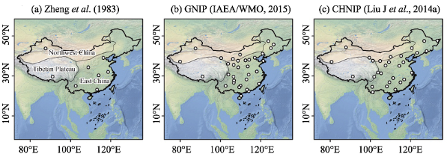
Figure 1 Spatial distribution of nationwide network for precipitation isotopes in China
The IAEA periodically released technique reports of Environmental Isotope Data: World Survey of Isotope Concentration in Precipitation since the 1960s, but the vast land of China was not well covered during the initial three decades, except a coastal station Hong Kong (IAEA/WMO, 2015). In the 1980s, some research institutes in China tried to contact IAEA, and precipitation samples or measured isotopic data were gradually submitted to GNIP. In the published issue covering GNIP data in 1984-1987 (IAEA, 1990), the monthly isotopic data in Shijiazhuang, Kunming, Xi’an and Guangzhou were included (Zhang, 1989); in the issue covering the 1988-1991 data (IAEA, 1994), more stations were added, including Guilin (Liu et al., 1987; Tu et al., 2004) as well as Qiqihar, Hotan, Yinchuan, Tianjin, Lhasa, Changsha, Guiyang, Nanjing, Fuzhou and Haikou (Zhao et al., 1995). Much more isotopic data were released later as a part of the GNIP database (Zhang et al., 1991; Liu et al., 1997a, 1997b). Shown in Figure 1b, there were a total of 33 sampling stations with monthly frequency in China, and there were 27 stations with monthly δ18O data no less than 24 months (IAEA/WMO, 2015). Using the annual weighted isotopic data in precipitation at 20 GNIP stations (Gu, 2011), the meteoric water line of China was δD=7.7δ18O+7.0 (n=20). Based on all the monthly data at 33 stations available (IAEA/WMO, 2015), the meteoric water line of China was determined as δD=7.5δ18O+6.1 (r2=0.94, n=2299).
However, all the GNIP stations in China suspended observations in the early 2000s, except Hong Kong (IAEA/WMO, 2015). In order to continue systematic observations nationwide, a new observation network named the Chinese Network of Isotopes in Precipitation (CHNIP) was established based on the Chinese Ecosystem Research Network (CERN) in 2004 (Figure 1c), and precipitation was monthly sampled and then analyzed for stable hydrogen and oxygen isotopes (Song et al., 2007). Using the observations at the initial years of CHNIP, Liu J et al. (2008, 2009, 2010) analyzed the regional patterns of isoscape in China. Based on the observations at 29 CHNIP stations from 2005 to 2010, Liu J et al. (2014) reviewed the main pattern of precipitation isotope in China, and presented a comparison between CHNIP and GNIP. Based on the CHNIP during 2005-2010 (Liu J et al., 2014), a recent meteoric water line of China was determined as δD=7.48δ18O+1.01 (r2=0.94, n=928).

2.2 Regional network

To investigate the precipitation isotopes for a specific region, the existing nationwide observation networks are usually not enough. With the rapid development of measurement instrument, precipitation isotopes were analyzed in a number of sites across China in recent years. Here we summarized the recent measurements of precipitation isotopes for each natural zone in China.
(1) Cold area of the Tibetan Plateau
The Tibetan Plateau with a mean altitude >4000 m a.s.l. covers a vast area in China, but the in-situ observation in the GNIP and CHNIP database is always limited (see Figures 1b and 1c). To improve the knowledge for this region, an observation platform, later named as the Tibetan Plateau Network of Isotopes in Precipitation (TNIP), was established (Yao et al., 2013), and a great number of isotope studies have been carried out based on TNIP (e.g., Tian et al., 2007, 2008; Yu et al., 2007, 2008, 2009, 2015a, 2015b, 2016; Liu Z et al., 2007, 2008b, 2010; Gao et al., 2009, 2011; Wen et al., 2012; Ren et al., 2013). An earlier review of TNIP was presented by Yu et al. (2006). Based on the long-term TNIP observations and simulations, Yao et al. (2013) reviewed the climatic controls on stable oxygen isotope in precipitation across the Tibetan Plateau, and demonstrated that the northern and southern portions are dominated by the westerly and monsoon moisture, respectively. In addition, the Qilian Mountains at the northeastern margin (e.g., Zhang and Wu, 2007a, 2007b; Wang et al. 2008; Zhao et al., 2011b; Wu H et al., 2014a; Li Z et al., 2015a, 2015b; Cui and Li, 2015) and the Hengduan Mountains at the southeastern margin (e.g. Xu et al., 2006, 2008; Song et al., 2015) of the plateau have also been investigated in many studies.
(2) Arid area of Northwest China
In the arid area of Northwest China, the studies of precipitation isotopes mainly focused on the Tianshan Mountains and the Hexi Corridor. For the Tianshan Mountains, the upper and middle reaches of the Urumqi River Basin has aroused great interest, which made the small inland river basin a hot spot of precipitation isotope studies since the late 1990s (e.g., Yao et al., 1999; Hou et al., 1999; Zhang et al., 2003; Pang et al., 2011; Feng et al., 2013; Kong et al., 2013); the strong temperature effect as well as the processes affecting precipitation isotopes in this watershed was analyzed, but the isotope studies beyond this basin (e.g., Wang X et al., 2015) were scarce. In 2012, an observation network with more than 20 stations was established around the Tianshan Mountains, which was useful to understand the spatial pattern of precipitation isotopes across this region (Wang, 2015; Wang et al., 2016a, 2016b, 2016c). For the Hexi Corridor (sometimes referred to as the Extensive Hexi Region, including the Hexi Corridor and the Qilian Mountains), some studies were carried out (e.g., Wu et al., 2010, 2011; Ma J et al., 2012; Guo et al., 2015a), which were reviewed by Hu et al. (2014) and Guo et al. (2015b). Besides the Tianshan Mountains and the Hexi Corridor, studies on other parts were relatively limited (e.g., Wu J et al., 2012; Yin et al., 2011).
(3) Monsoon area of East China
For the northern portion of the monsoon area of East China (divided by the Qinling Mountains-Huaihe River Line), the precipitation isotopes at some experiment watersheds were analyzed, e.g., Liu et al. (2005) and Liu X et al. (2007). In the Beijing City, the precipitation isotopes have been discontinuously measured in the past decades (e.g., Wei et al., 1982; Zheng et al., 1983; Wen et al., 2010; Tao et al., 2013; Zhai et al., 2013; Li J et al., 2015); in the Lanzhou City, an intensive observation network has been implemented, which was useful to understand the micro climate controls on precipitation isotopes (Ma et al., 2014; Chen et al., 2015a, 2015b). In addition, a precipitation isotope network was recently established across the Haihe River basin, and seven sampling stations were included in this network (Pang et al., 2015; Zhao et al., 2015).
For the southern portion of this region, the precipitation isotopes have been reported at many cities, and seasonal pattern and moisture source were analyzed, including Changsha (Wu et al., 2015; Wu H et al., 2012, 2014b; Huang et al., 2013, 2015; Li G et al., 2015), Guangzhou (Xue et al., 2007, 2008; Xie et al., 2011; Yang et al., 2011; Yin et al., 2012; Liao et al. 2012), Guilin (Wu X et al., 2014; Zhang M et al., 2015), Nanjing (Tang et al., 2015), Chongqing (Li et al., 2010) and others (Zheng et al., 2009; Zhang et al., 2010; Chen et al., 2010). In addition, the in-situ observation of precipitation isotopes across the Taiwan Island was also reported by Peng et al. (2010, 2011, 2012).

2.3 Development of measurement technique

The development of commercial measurement instrument for analyzing water stable isotopic ratios resulted in the availability of more and more data in hydrological and climate studies. Generally, the currently used measurement techniques in China include the isotope ratio mass spectrometer (IRMS) and the isotope ratio infrared spectroscopy (IRIS).
IRMS, as a traditional method, has been frequently applied to measure water stable isotopic ratios for a long period in China (e.g., Zheng et al., 1983; Liu et al., 1987; Yao et al., 2013; Liu J et al., 2014). A brief development history of IRMS in the past decades as well as the typical commercial IRMS productions was introduced by Lin (2013), and the main types included dual-inlet IRMS, continuous flow IRMS, GC-C/TC-IRMS and so on. Yang et al. (2012) presented an inter-comparison of stable isotopes in sea water and groundwater using three commercial analyzers (Finnigan MAT253, MAT252 and Delta-plus).
In the past several years, IRIS has provided an important alternative to the traditional IRMS due to its ease of use, low cost and potential of fieldwork, which led to a rapid development of water isotope studies in China. As seen in the recent publications, there were three commercial IRIS productions, including: (1) off-axis integrated cavity output spectroscopy (OA-ICOS) by Los Gatos Research Inc., e.g., Wu et al. (2015); (2) wavelength-scanned cavity ring-down spectroscopy (WS-CRDS) by Picarro Inc., e.g., Tang et al. (2015); and (3) tunable diode laser absorption spectroscopy (TDLAS) by Campbell Scientific Inc., e.g., Wen et al. (2010). An inter-comparison of four commercial analyzers was carried out by Wen X et al. (2012), including analyzers from Campbell Scientific (TGA100A), Picarro (L1115-i and L1102-i) and Los Gatos Research (DLT-100). Comparisons of water isotopic analysis using IRMS and IRIS were also conducted by Zhao et al. (2011a), Liu et al. (2013) and Zhang L et al. (2015).

3 Precipitation isoscape

The spatial distribution of stable isotopes in precipitation, also known as isoscape, is important in isotope studies. To investigate the isoscape of precipitation in China on a national scale, great efforts have been made during the last decades. The development of isoscape productions corresponded to the establishment of observation network and the improvement of calculation approach. From the traditional manual drawing to the computer-aided mapping, and then to the simulation using isotope-equipped climate models, a series of isoscape productions in China has been released in the past. The main development stages were listed below:
(1) Simple spatial interpolation
Before the wide use of computer-aided interpolation technique especially for geographical information system (GIS), scientists have to manually draw the spatial distribution based on the known data at sampling sites (e.g., Yu and Li, 1997; Liu et al., 1997a; Zhang and Yao, 1998). For the regions without enough observations, some empirical relationship may be considered. Since the 2000s, computer-aided interpolation technique operated in ArcGIS, Surfer or other programs has been frequently applied in geography, which provided a practical approach to create precipitation isoscape (e.g., Luo et al., 2008; Li et al., 2014b). However, these simple spatial interpolation methods were still not very good at predicting the unmeasured sites at small scales, especially under a complex topography.
(2) Interpolation with spatial and climate variables
The precipitation isotopes are usually related to spatial variables (e.g., latitude, longitude and elevation) and/or climate variables (e.g., temperature) (Liu J et al., 2014). With the advanced support of GIS, these geographical and meteorological controls can be practically considered in isoscape productions. Based on a global isoscape model (δ18O=a|L|2+b|L|+cA+ d, where L and A are latitude and altitude, respectively; sometimes called BW model) developed by Bowen and Wilkinson (2002), Liu Z et al. (2008a, 2009) calculated precipitation isoscape in China with consideration of latitude and altitude, and then Yang et al. (2014) reevaluated the model. Zhao L et al. (2012) changed the altitude parameter to air temperature, and developed a new second-order regression for each month (δ18O=aL2+bL+cT+d, where L and T are latitude and temperature, respectively). In addition, using an interpolation with a variable of surface air temperature, the precipitation isoscape in China was also calculated by Li et al. (2011c).
(3) Isotope-enabled climate model simulation
The in-situ measurements of precipitation isotopes can be incorporated to general circulation models (GCMs) or regional circulation models (RCMs), and the precipitation and vapor isoscape can be simulated at different spatial and temporal scales. In recent years, the stable isotope-enabled GCMs were widely used, which provided meaningful information about regime controlling precipitation isotopes in China (Yao et al., 2013). Generally, these published simulation studies can be classified into two types: (a) Reproduced using the global isotopic output released by the Stable Water Isotope Intercomparison Group (SWING) and its second stage (SWING2) (Risi et al., 2012), e.g., Zhang et al. (2012) based on SWING and Wang S et al. (2015) based on SWING2. (b) Simulated with local isotope input (mainly on the Tibetan Plateau), e.g., Gao et al. (2011, 2013, 2015, 2016), Yao et al. (2013), He et al. (2015a, 2015b). In addition, other models can also be used to generate isoscapes in China, such as the isotope Atmospheric Water Balance Model (iAWBM) (Zhang X P et al., 2015).

4 Environmental significance of isotopes

4.1 Meteorological controls

Gu (2011) summarized that the stable isotopes in precipitation are mainly influenced by three factors including water molecule characteristics (e.g., mass number and specific heat), moisture source region condition (e.g., location, vapor transport intensity and evaporative condition) and precipitation region condition (e.g., temperature effect, amount effect, latitude effect, altitude effect and continental effect). The factors controlling stable isotopes in precipitation are vital information, and the environmental effect of precipitation isotope aroused great attention in past decades.
The temperature and precipitation amount are major meteorological factors influencing stable isotopes in precipitation. The fractionation of isotopes during evaporation and condensation is related to air temperature. Figure 2a shows the spatial distribution of correlation coefficients between stable oxygen isotope and air temperature based on the national and some regional networks (IAEA/WMO, 2015; Liu J et al., 2014; Yao et al., 2013). Across China, temperature effect at the northern portion is much more significant than that at the southern portion. Regarding the amount effect, the high correlation coefficients between δ18O and precipitation amount mainly occur at the southern portion of China (Figure 2b). In addition, a stepwise regression model was applied to the GNIP and CHNIP stations by Liu J et al. (2014), and the monthly value of δ18O in precipitation can be estimated using corresponding meteorological parameters including air temperature, precipitation amount, relative humidity, vapor pressure, sunshine duration, wind speed and direction.
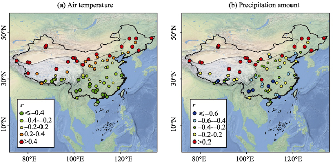
Figure 2 Spatial distribution of correlation coefficients between precipitation δ18O and meteorological parameters (a. air temperature, b. precipitation amount) in China (data are acquired from Yao et al., 2013; Liu J et al., 2014; IAEA/WMO, 2015)
The main moisture transport paths in China include the East Asian monsoon, the Indian monsoon and the Westerly, and the precipitations controlled by different source regions and atmospheric circulation patterns usually present different isotopic ratios (Zhang et al., 2004; Yu et al., 2014; Cai and Tian, 2016). In the Tibetan Plateau (Tian et al., 2007; Yao et al., 2013), the westerly-dominant regions (northern portion) showed enriched isotopes in summer and depleted isotopes in winter, but the Indian monsoon-dominant regions (southern portion) exhibited an obvious decreasing trend of δ18O from spring to summer. In eastern China (Tan and Nan, 2010; Tan, 2014; Huang et al., 2015), the intensity co-variation of moistures from the Indian and Pacific Oceans may lead to a variation of precipitation isotopes. In the Tianshan Mountains dominated by the westerly, Liu et al. (2015) analyzed the impact of moisture transport path on precipitation isotopes, and found an interannual difference in isotopes caused by the high and low latitude sources. In some event-based isotope studies, the influence of moisture source region was very sensitive (Pang et al., 2006). For instance, based on the rain samples collected during an extreme event (21-22 July, 2012, collected at frequencies between 10 min and 2 h) in the Beijing City (Tao et al., 2013; Li et al., 2015), the contributions from southern and southeastern moistures were detected. In the Tianshan Mountains (Wang, 2015), the stable isotopes in event-based samples were considered to be related to the duration of moisture transport.

4.2 Geographical controls

As mentioned in Section 3, the variation of stable isotopes in precipitation is related to latitude and elevation (Liu Z et al., 2008a, 2009; Yang et al., 2014). Based on the CHNIP stations covering an elevation range from 3 m to 3688 m a.s.l., Liu J et al. (2014) presented a regression model as δ18O=8.892-0.041LON-0.312LAT-0.002ALT where LON, LAT and ALT are longitude (°), latitude (°) and altitude (m), and partial correlation coefficients are 0.040, 0.369 (p<0.05), 0.190 (p<0.05), respectively. The gradient between precipitation δ18O and latitude was -0.22‰/° based on CHNIP (Liu J et al., 2014), which was very similar to the GNIP-based result in eastern China (-0.23‰/°; Gu, 2011).
Based on the CHNIP database, the linear gradient between precipitation δ18O and altitude was -0.13‰/100 m in China, and the CHNIP sites across the Tibetan Plateau showed a much lower value (-0.3‰/100 m) than the nationwide result (Liu J et al., 2014). However, in the TNIP database (Yao et al., 2013), the gradients are -0.17‰/100 m for the westerly-dominant portion and -0.13‰/100 m for the monsoon-dominant portion of the Tibetan Plateau; Some other values are also reported in previous studies for this region (Yao et al., 2009). These different gradients between isotopic ratio and elevation are greatly related to the spatial and temporal representativeness of sampling stations.

4.3 Isotopes as climate proxy

If the stable isotopes in precipitation are well recorded in ice core, speleothems or other climate proxies, the climate information in the past can be reconstructed using the isotopic technique. During recent years, the relationship between δ18O in ice cores and surface air temperature have been widely investigated at many glaciers in China, e.g., Muztagata Glacier (Tian et al., 2006), Dunde Ice Cap (Yao and Thompson, 1992), Guliya Glacier (Yao et al., 1996), Malan Ice Cap (Wang et al., 2003), Puruogangri Glacier (Yao et al., 2006), Geladaindong Glacier (Kang et al., 2007), Noijin Kangsang Glacier (Zhao H et al., 2012), East Rongbuk Glacier (Zhang et al., 2005), Dasuopu Glacier (Yao et al., 2002) and Miaoergou Ice Cap (Song et al., 2011). Generally, for the ice cores drilled at the northern portion controlled by the westerlies, the temperature effect in ice cores was widely accepted, unless great elution occurred; however, for those at the southern portion controlled by monsoon moisture, the explanations of stable isotopes in ice cores were relatively complex. Zhao et al. (2014) reviewed the environmental significance of stable isotopes in 10 typical ice cores, and found that the normalized ice core δ18O positively correlated with air temperature for northern portion (r=0.53) and southern portion (r=0.44), respectively. In addition, to investigate the influence of post-deposition of the stable isotope in snow-firn-ice evolution, a series of field work was carried out at the Urumqi Glacier No. 1 in the Tianshan Mountains, e.g., Hou et al. (1999), Zhang et al. (2009), Li et al. (2011a, 2011b), Wang et al. (2011).
Besides the ice core studies, many investigations on environmental significance of speleothems isotopes were also carried out, and the isotopic evolutions from rainfall to drip water were observed across China, e.g., Luo et al. (2013, 2014), Wu X et al. (2014), Tan et al. (2015), Zeng et al. (2015). Luo et al. (2008) and Peng and Li (2012) reviewed some progress on this subject; the main conclusion was that the drip water isotopes is jointly influenced by precipitation isotopic ratio and local environment, and the explanations of monsoon intensity and circulation effect were popular in speleothems isotope studies.

5 Sub-cloud evaporation and moisture recycling

5.1 Raindrop sub-cloud evaporation

The sub-cloud secondary evaporation of falling raindrops may greatly influence the isotopic ratios, which makes δ-value and D-excess in near-ground samples different from that below cloud base. In a study of water vapor isotopes in China derived from satellite measurements, Liu Z et al. (2014) found that below-cloud evaporation is a key driver causing the difference of isotopes from vapor to precipitation in non-monsoon regions. Usually, precipitation impacted by sub-cloud evaporation may show an enriched δ-value and decreased D-excess, and the slope and intercept of meteoric water line also changes. The variations of isotopic ratio and meteoric water line under different meteorological conditions were frequently used to reflect the existence of sub-cloud evaporation (e.g., Meng and Liu, 2010; Wu et al., 2015; Chen et al., 2015b; Zhao et al., 2015).
The quantitative estimation of isotopic variation from cloud base to near-ground caused by sub-cloud process has aroused attentions in recent years. Using a cloud physics model, Zhang et al. (1998) simulated the variation of stable isotopes in raindrops; the results indicated that δ18O in falling raindrop gradually enriches through unsaturated air, but D-excess shows a decreasing-and-increasing trend with a transition height depending on relative humidity and raindrop size. Kong et al. (2013) used a model developed by Froehlich et al. (2008) to describe the D-excess variation from cloud base to ground, and presented a linear relationship that 1% of raindrop evaporation corresponds to approximately 1‰ of D-excess decrease, which coincided with previous report in the European Alps (Froehlich et al. 2008). However, the meteorological input in this model is not available for most studies, so the slope of ~1‰/1% was often applied to estimate the evaporation proportions (e.g., Peng et al., 2010; Ma et al., 2014; Chen et al., 2015b; Jin et al., 2015). It should be mentioned that the relationship of ~1‰/1% are derived from a low evaporation condition with remaining fraction of raindrop mass >95% (Kong et al., 2013; Froehlich et al. 2008), and more arid climate should be considered. Based on an observation network around the Tianshan Mountains, Wang et al. (2016b) calculated a wider range of remaining fraction from ~0% to 100%, and found that the correlations between D-excess difference and raindrop remaining fraction are relatively weak under a condition of high evaporation; under meteorological conditions of air temperature ≥20°C or relative humidity <70%, the regression coefficient is up to ~1.5‰/1%.

5.2 Recycled moisture in precipitation

The recycled moisture in precipitation denotes the precipitation sustained by evapotranspiration, including water vapor originating from evaporation and transpiration of land surface, and usually plays an important role in continental precipitation (Brubaker et al., 1993). In a conceptual model, the precipitating vapor can be assumed as an intensive mixture of advected and recycled vapor, and the contributions of advection, evaporation and transpiration in local precipitation can be calculated using isotopic ratios in each component (Peng et al., 2011). This type of models is sometimes called the three-component mixing model. It is clear that systemic measurements for stable isotopes in each water body (precipitation, vapor, surface water, plant, soil and others) are very useful to calculate the contribution of recycled moisture; however, the precipitation isotope is the vital input, and the isotopes in other carriers can be estimated using precipitation isotopes if necessary (e.g., Peng et al., 2011; Wang et al., 2016a).
The three-component mixing model has been applied in many regions in China during recent years (Table 1). Peng et al. (2011) calculated the contribution of locally recycled moisture in the Taiwan Island, and found that the contributions from advection, evaporation and transpiration are 58%-71%, 1%-2% and 28%-41%, respectively. Ma Q et al. (2012) used a similar method to investigate the Tibetan Plateau, and showed that the contributions of recycled moisture have seasonal difference between summer and winter months. At the oasis sites near the Tianshan Mountains in Northwest China, Wang et al. (2016a) found that transpiration contribution at large oasis (like Urumqi) is much greater than that at small oasis. Generally, the relative contribution for each component is related to the surface meteorological conditions (especially air temperature and relative humidity), underlying surface landcover (vegetation, open water or others) and study domain.
Table 1 Contributions of each component (fadv-advection, fev-evaporation and ftr-transpiration) in local precipitation in previous studies
In some cases that evaporation flux is considered to be significantly greater than transpiration flux (e.g., stations near large open water or covered by bare soil), the precipitating vapor can be assumed as a mixture of advection and evaporation vapors (excluding transpiration). This type of models is usually called the two-component mixing model. Xu et al. (2011) calculated the contribution of evaporation from the Nam Co Lake in the Tibetan Plateau using isotopic method, and found a proportion between 28.4% and 31.1% during the period 2005-2008. In another studies at the Qinghai Lake in the northeastern Tibetan Plateau (Cui and Li, 2015), the evaporation contribution from the lake was estimated to be 23.4% (equals 90.5 mm), ranging from 3.0% in October to 37.9% in August. Compared with lakeside sites, the evaporation contribution reported in other studies are usually much lower (e.g., Kong et al., 2013; Ma et al., 2013), and some mountainous stations even show a negligible contribution (<0.1%).

6 Summary and outlook

The recent progress in precipitation stable isotope studies across China was reviewed in this study. During past decades, the nationwide observation network for precipitation isotopes has been established, which is important to investigate the main isotopic pattern in China. As analyzing technique develops in recent years, a great number of water isotopic data are available for scientific research, and the newly supplemented in-situ measurements greatly improve the knowledge at different areas. The main factors controlling precipitation stable isotopes in China was generally clear, especially for temperature and amount effects, although the environmental significance of isotopes at interdecadal and synoptic scales may need more studies. Based on the more and more in-situ observations, the precipitation isotope has been frequently used to estimate the recycled moisture in local precipitation as well as other aspects in hydrological and climate studies.
With the great improvements in research method and measurement technique, more hydrological process can be detected, and the following aspects should be focused on in future research. (1) The connection between stable isotopes in precipitation and water vapor. In recent years, the vapor isotopes across China have been continuously measured using isotopic ratio infrared spectroscopy at more and more sites as well as satellite techniques, which can remove the disadvantage of logical discontinuity in precipitation isotopic records. The different information of isotopes in precipitation and water vapor should be paid more attention. (2) Micro and synoptic scale diagnoses using isotopic method. The precipitation isotopic variations at a small domain or short time period were not well considered in the previous studies, but the information within the process at micro and synoptic scale is very useful in hydrological and climate research. (3) Potential of 17O in precipitation. As a stable isotope of oxygen, 17O has aroused great attention in recent years, mainly caused by the recent technique development. However, in the publication available, the studies on precipitation 17O and 17O-excess across China are still nearly absent. (4) Wide use of isotope-enabled GCM simulations. The isotope-enabled GCMs in recent publications show good performance describing dynamical and microphysical processes, especially over the Tibetan Plateau, and this approach can be applied in a wider scope across China.

The authors have declared that no competing interests exist.

1
Bowen G J, Wilkinson B H, 2002. Spatial distribution of δ18O in meteoric precipitation.Geology, 30(4): 315-318.

2
Brubaker K L, Entekhabi D, Eagleson P S, 1993. Estimation of continental precipitation recycling.Journal of Climate, 6(6): 1077-1089.Abstract The total amount of water that precipitates on large continental regions is supplied by two mechanisms: 1) advection from the surrounding areas external to the region and 2) evaporation and transpiration from the land surface within the region. The latter supply mechanism is tantamount to the recycling of precipitation over the continental area. The degree to which regional precipitation is supplied by recycled moisture is a potentially significant climate feedback mechanism and land surface-atmosphere interaction, which may contribute to the persistence and intensification of droughts. Gridded data on observed wind and humidity in the global atmosphere are used to determine the convergence of atmospheric water vapor over continental regions. A simplified model of the atmospheric moisture over continents and simultaneous estimates of regional precipitation are employed to estimate, for several large continental regions, the fraction of precipitation that is locally derived. The results indicate that the contribution of regional evaporation to regional precipitation varies substantially with location and season. For the regions studied, the ratio of locally contributed to total monthly precipitation generally lies between 0.10 and 0.30 but is as high as 0.40 in several cases.

DOI

3
Cai Z, Tian L, 2016. Atmospheric controls on seasonal and interannual variations in the precipitation isotope in the East Asian Monsoon region.Journal of Climate, 29(4): 1339-1352. doi: 10.1175/JCLI-D-15-0363.1.Abstract Understanding variations in isotopic composition of precipitation from monsoon regions is crucial for its utilization in paleoclimate studies. Here we explore the relations between precipitation δ 18 O data for the East Asian Monsoon (EAM) region archived in GNIP and the cloud data archived in ISCCP and their linkage with large-scale atmospheric circulation patterns. Results show that precipitation δ 18 O are significantly and positively correlated with cloud top pressure (CTP) on both local and regional scales. Mechanically-speaking, the stronger the monsoon convection precipitation, the higher the cloud and the lower the condensation temperature, and thus the lower the precipitation δ 18 O. This result implies that the sharp drop in precipitation δ 18 O in the early summer in monsoonal Asia is related to the atmospheric circulation pattern, rather than the different moisture sources, as was previously assumed. This result helps explain the processes leading to the observed “amount effect”. A comparison of atmospheric circulation patterns with precipitation δ 18 O on an interannual scale shows that the positive CTP anomalies in the Central Indo-Pacific within the weak Walker Circulation (El Ni09o) can be associated with positive δ 18 O anomalies, while negative CTP anomalies in the Central Indo-Pacific within the strong Walker Circulation (La Ni09a) can be linked to negative δ 18 O anomalies. This result further confirms the aforementioned conclusion. This is important for understanding paleoclimatic change in monsoonal Asia, as interannual variations in stable isotopes in that region have received less attention in the past.

DOI

4
Chen F, Zhang M, Ma Qet al., 2015a. Stable isotopic characteristics of precipitation in Lanzhou City and its surrounding areas, Northwest China.Environmental Earth Sciences, 73(8): 4671-4680.Based on the precipitation samples obtained at Lanzhou City (36°06′N, 103°44′E, 1,548m a.s.l.) in western China and its surrounding counties (Yongdeng, Gaolan, and Yuzhong) from April 2011 to February 2013, the characteristics of stable isotopes in precipitation and the correlations between δ 18 O and meteorological factors were analyzed. The LMWL (local meteoric water line) of Lanzhou City and its surrounding areas was calculated, and the order of LMWL slopes in the four stations is Yuzhong (7.70)>Lanzhou (7.57)>Yongdeng (7.24)>Gaolan (6.80). Both the slope and intercept of the LMWLs for each station are less than those of the global meteoric water line. There is a weakly positive correlation between δ 18 O and air temperature, and the correlation between δ 18 O and precipitation amount is weakly negative. Evidenced from the slope and intercept of LMWL and the relationship between δ 18 O and relative humidity, there is secondary evaporation when the precipitation falls from clouds to the ground.

DOI

5
Chen F, Zhang M, Wang Set al., 2015b. Relationship between sub-cloud secondary evaporation and stable isotope in precipitation of Lanzhou and surrounding area.Quaternary International, 380/381: 68-74.Based on the 420 samples of precipitation and related meteorological parameters obtained from the four sampling sites (Yongdeng, Gaolan, Lanzhou and Yuzhong) in Northwest China from April 2011 to February 2013, the influence of sub-cloud secondary evaporation effect on stable isotopes in precipitation was analyzed. Four main factors affecting the secondary evaporation were precipitation, air temperature, water vapor pressure, and relative humidity. The results showed that sub-cloud secondary evaporation had a significant effect on isotopes when the rainfall amount was small, but the correlation was not significant for snowfall or heavy rainfall. As the temperature increased, the secondary evaporation was enhanced. Water vapor pressure greatly impacted the sub-cloud secondary evaporation of the rain, but had less influence on the snow events. Relative humidity showed an influence on d-excess value, as well as the slope and intercept of the 未D-未 18 O correlation equation of light rainfall, but had a small impact when snow occurred. The estimated secondary evaporation rate was generally lower in winter and higher in summer, and spatially varied depending on locations. During the summer monsoon period (June to September), the secondary evaporation rate was estimated to be between 5.90% and 10.50% for each station with the mean value of 8.30%, and during the winter monsoon period (October to May), the rate was between 3.20% and 5.62%, with the average value of 4.54%.

DOI

6
Chen J, Cao J, Huang Y, 2010. The hydrogen and oxygen isotope composition of precipitation in the Xiamen coastal area.Journal of Marine Sciences, 28(1): 11-17. (in Chinese)The hydrogen and oxygen isotope compositions of rainwater collected from 44 rain events in the Xiamen coastal area during April 2004 to April 2006 were studied. The rainfall δ18O range from -10.30‰ to -0.13‰, with a mean value of -3.67‰, and the δD values have a wide range, varying from -74.7‰ to 7.3‰, with an average of -20.5‰. These data are comparable to those already reported for other areas. The factors which controlled the composition of hydrogen and oxygen isotope in precipitation were discussed and the latitude effect was an important factor. The seasonal variations of δ18O, δD were great, and the monsoon climate and rainfall effect played an important role in the seasonal variations. The d values for precipitation fell in the range from 1.21‰ to 17.10‰ with an average of 8.87‰ which were lower than that of the globe average value, suggested that the evaporation rate was slow at the moisture source area and the vapour sources of precipitation mainly originated from ocean air masses. The meteoric water line (δD=7.67δ18O+7.68) obtained for the region reflected that the re-evaporation from falling droplets was existed, especially in the summer.

7
Cui B L, Li X Y, 2015. Stable isotopes reveal sources of precipitation in the Qinghai Lake Basin of the northeastern Tibetan Plateau.Science of the Total Environment, 527/528: 26-37.The use of isotopic tracers is an effective approach for characterizing the moisture sources of precipitation in cold and arid regions, especially in the Tibetan Plateau (TP), an area of sparse human habitation with few weather and hydrological stations. This study investigated stable isotope characteristics of precipitation in the Qinghai Lake Basin, analyzed moisture sources using data sets from NCEP–NCAR, and calculated vapor contributions from lake evaporation to the precipitation in the basin using a two-component mixing model. Results showed that the Local Meteoric Water Line (LMWL) was defined as δ 2 H02=027.86 δ 18 O02+0215.01, with a slope of less than 8, indicating that some non-equilibrium evaporation processes occurred when the drops fell below the cloud base. Temperature effects controlled δ 18 O and δ 2 H in precipitation in the basin, with high values in summer season and low values in winter season. Moisture in the basin was derived predominantly from the Southeast Asian Monsoon (SEAM) from June to August and the Westerly Circulation (WC) from September through May. Meanwhile, the transition in atmospheric circulation took place in June and September. The SEAM strengthened gradually, while the WC weakened gradually in June, and inversely in September. However, the Southwest Asian Monsoon (SWAM) did not reach the Qinghai Lake Basin due to the barrier posed by Tanggula Mountain. High d-excess (>0210‰) and significant altitude and lake effects of δ 18 O in precipitation suggested that the vapor evaporated from Qinghai Lake, strongly influenced annual precipitation, and affected the regional water cycle in the basin distinctly. The monthly contribution of lake evaporation to basin precipitation ranged from 3.03% to 37.93%, with an annual contribution of 23.42% or 90.5402mm, the majority of which occurred in the summer season. The findings demonstrate that the contribution of evaporation from lakes to atmospheric vapor is fundamental to water cycling on the TP.

DOI PMID

8
Feng F, Li Z, Zhang Met al., 2013. Deuterium and oxygen 18 in precipitation and atmospheric moisture in the upper Urumqi River Basin, eastern Tianshan Mountains.Environmental Earth Sciences, 68(4): 1199-1209.The contribution of stable isotopes in meteorological, climatological and hydrological research is well known. This study analyzed the deuterium and oxygen 18 contents (delta D and delta O-18) of precipitation in event-based samples at three stations (Glacier No. 1, Zongkong, Houxia) along the upper Urumqi River Basin from May 2006 to August 2007. The delta O-18 in precipitation revealed a wide range and a distinct seasonal variation at all three stations, with enriched values occurring in summer and depleted values in winter. A statistically significant positive correlation was observed between the delta O-18 and delta D and local surface air temperature, and better linear relationship existed between delta O-18 and air temperature than that of delta D. This suggests that paleoclimatic archives relating to precipitation delta O-18 and delta D can be useful for qualitative temperature reconstruction. The d-excess in precipitation also exhibited a seasonal variability. Based on NCEP/NCAR reanalysis data, three-dimensional isentropic back-trajectories in HYSPLIT model were employed to determine the moisture source for each precipitation event. Results indicate a dominant effect of westerly air masses in summer and the integrated influence of westerly and polar air masses in winter, and d-excess can be used as a sensitive tracer of the moisture transport history.

DOI

9
Froehlich K, Kralik M, Papesch Wet al., 2008. Deuterium excess in precipitation of Alpine regions: Moisture recycling.Isotopes in Environmental and Health Studies, 44(1): 61-70.Abstract The paper evaluates long-term seasonal variations of the deuterium excess (d-excess = delta(2)H - 8. delta(18)O) in precipitation of stations located north and south of the main ridge of the Austrian Alps. It demonstrates that sub-cloud evaporation during precipitation and continental moisture recycling are local, respectively, region

DOI PMID

10
Gao J, Masson-Delmotte V, Risi Cet al., 2013. What controls precipitation δ18O in the southern Tibetan Plateau at seasonal and intra-seasonal scales? A case study at Lhasa and Nyalam.Tellus B, 65: 21043. doi: 10.3402/tellusb.v65i0.21043.

11
Gao J, Masson-Delmotte V, Yao Tet al., 2011. Precipitation water stable isotopes in the South Tibetan Plateau: Observations and modeling.Journal of Climate, 24(13): 3161-3178.Measurements of precipitation isotopic composition have been conducted on a daily basis for 1 yr at Bomi, in the southeast Tibetan Plateau, an area affected by the interaction of the southwest monsoon, the westerlies, and Tibetan high pressure systems, as well as at Lhasa, situated west of Bomi. The measured isotope signals are analyzed both on an event basis and on a seasonal scale using available meteorological information and airmass trajectories. The processes driving daily and seasonal isotopic variability are investigated using multidecadal climate simulations forced by twentieth-century boundary conditions and conducted with two different isotopic atmospheric general circulation models [the isotopic version of the Laboratoire de Meteorologie Dynamique GCM (LMDZiso) and the ECHAM4iso model]. Both models use specific nudging techniques to mimic observed atmospheric circulation fields. The models simulate a wet and cold bias on the Tibetan Plateau together with a dry bias in its southern part. A zoomed LMDZ simulation conducted with similar to 50-km local spatial resolution dramatically improves the simulation of isotopic compositions of precipitation on the Tibetan Plateau. Simulated water isotope fields are compared with new data and with previous observations, and regional differences in moisture origins are analyzed using back-trajectories. Here, the focus is on relationships between the water isotopes and climate variables on an event and seasonal scale and in terms of spatial and altitudinal isotopic gradients. Enhancing the spatial resolution is crucial for improving the simulation of the precipitation isotopic composition.

DOI

12
Gao J, Risi C, Masson-Delmotte Vet al., 2016. Southern Tibetan Plateau ice core δ18O reflects abrupt shifts in atmospheric circulation in the late 1970s.Climate Dynamics, 46(1): 291-302. doi: 10.1007/s00382-015-2584-3.

13
Gao J, Shen S S P, Yao Tet al., 2015. Reconstruction of precipitation δ18O over the Tibetan Plateau since 1910.Journal of Geophysical Research: Atmospheres, 120(10): 4878-4888.

14
Gao J, Tian L, Liu Yet al., 2009. Oxygen isotope variation in the water cycle of the Yamzho Lake Basin in southern Tibetan Plateau.Chinese Science Bulletin, 54(16): 2758-2765.

15
Gu W, 2011. Isotope Hydrology. Beijing: Science Press. (in Chinese)

16
Guo X, Feng Q, Li Zet al.2015a. Variation of stable isotopes and moisture sources in precipitation at the Dunhuang Basin in Northwest China.Journal of Desert Research, 35(3): 715-723. (in Chinese)In this study, event-based precipitation samples collected from October 2012 to October 2013 in the Dunhuang Basin in Northwest China, GNIP data and HYSPLIT model have been used to constrain the stable isotopes variations and moisture sources. The <em>δ</em>D, <em>δ</em><sup>18</sup>O and d-excess showed distinctively seasonal variations: with more positive <em>δ</em>D, <em>δ</em><sup>18</sup>O and lower d-excess values in summer and more negative <em>δ</em>D, <em>δ</em><sup>18</sup>O and higher d-excess values in winter. The relationship between local air temperature and stable isotopes in precipitation exhibited significant positive correlations, with a gradient of 6.89‰&#183;℃<sup>-1</sup> for <em>δ</em>D and 0.92‰&#183;℃<sup>-1</sup> for <em>δ</em><sup>18</sup>O. The local meteoric water line (LMWL), established as <em>δ</em>D=7.45<em>δ</em><sup>18</sup>O+2.72(<em>R</em><sup>2</sup>=0.98), had a lower slope and intercept than the global meteoric water line (GMWL), which was attributed to the effect of secondary evaporation, especially in summer. The variability of d-excess values in the Dunhuang Basin was mainly induced by the changes of air temperature and relative humidity. Generally, the moisture in the Dunhuang Basin was dominantly derived from westerly air masses all year round, and the region can receives polar air mass moisture transport in winter and spring, while some precipitation events was attributed to the water vapor transport from the southwest monsoon and local recycle moisture.

DOI

17
Guo X, Feng Q, Wei Yet al., 2015b. An overview of precipitation isotopes over the Extensive Hexi Region in NW China.Arabian Journal of Geosciences, 8(7): 4365-4378.

18
He Y, Gao J, Yao Tet al., 2015a. Spatial distribution of stable isotope in precipitation upon the Tibetan Plateau analyzed with various interpolation methods.Journal of Glaciology and Geocryology, 37(2): 351-359. (in Chinese)<p>The stable isotope (&delta;<sup>18</sup>O) on the Tibetan Plateau was interpolated by Cressman interpolation method and by optimum interpolation method after altitude correction. It is found that the performance of the optimum interpretation method is better than that of the Cressman interpretation method. Comprised with the results of regression model (BW model), the spatial distribution of &delta;<sup>18</sup>O interpolated by optimum interpretation method is also better. In the meanwhile, the &delta;<sup>18</sup>O spatial distribution on the southern Tibetan Plateau has been obviously improved through an altitude correction. However, the &delta;<sup>18</sup>O spatial distribution on the northern Tibetan Plateau has not been better after altitude correction.</p>

DOI

19
He Y, Risi C, Gao Jet al., 2015b. Impact of atmospheric convection on south Tibet summer precipitation isotopologue composition using a combination of in situ measurements, satellite data, and atmospheric general circulation modeling. Journal of Geophysical Research:Atmospheres, 120(9): 3852-3871.

20
Hou S, Qin D, Mayewski PAet al., 1999. Climatological significance of δ18O in precipitation and ice cores: A case study at the head of Urumqi River, Tien Shan, China.Journal of Glaciology, 45(151): 517-523.

21
Hu Y, Liu C, Lu Yet al., 2014. Application of environmental isotopes in understanding hydrological processes of the Heihe River Basin.Advances in Earth Science, 29(10): 1158-1166. (in Chinese)Recent studies using environmental isotopes (<sup>2</sup>H, <sup>3</sup>H, <sup>14</sup>C, <sup>18</sup>O, and <sup>222</sup>Rn) were summarized to trace hydrological processes in the Heihe River Basin (HRB). Isotopic values from various types of waters (i.e., precipitation, surface water, and groundwater) at multiple spatiotemporal scales within the basin have been synthesized. The measurements of &#x003b4;D and &#x003b4;<sup>18</sup>O values show that: precipitation in the upper-basin constitutes the primary source for surface water and shallow groundwater in the HRB; frequent surface water-shallow groundwater exchanges take place mainly in the middle HRB; and in the lower HRB, shallow groundwater is recharged primarily by river water while deep groundwater is largely isolated from modern recharge sources. This finding for the lower HRB is further confirmed by <sup>14</sup>C and <sup>3</sup>H measurements, which demonstrate that shallow, unconfined groundwater is younger than deep, confined groundwater. Future research should be focused more on increasing sampling resolution in time and space, utilizing multiple isotopes in tandem with other geochemical tracers for more quantitative research, as well as integrating results from isotope-based, geochemical investigations into construction and calibration of numerical models.

DOI

22
Huang Y, Zhang X, Sun Jet al., 2015. Seasonal variations of stable isotope in precipitation and atmospheric water vapor and their relationship with moisture transportation in Changsha City.Scientia Geographica Sinica, 35(4): 498-506. (in Chinese)<p>In this study, the variation and relationship of stable water isotope both in precipitation and atmospheric water vapor, the influence of different moisture sources and their strength during transportation on precipitation isotopes are analyzed by using precipitation events isotope that covered a period of Jan. 2010 to Dec. 2012 in Changsha and TES retrievals of daily HDO, H<sub>2</sub>O data from Mar. 2010 to Dec.2011. The results show that firstly, decreasing atmospheric water vapor isotope values with increasing altitude. Secondly, comparing atmospheric water vapor with precipitation, the former is more depleted in isotope. Thirdly, precipitation isotopes values are high in winter and spring, low in summer and fall, referring to water vapor isotope, it is high in spring and summer, low in fall and winter. Fourthly, isotopes both in water vapor and precipitation have evident fluctuation. Moisture trajectories of precipitation events for summer and winter in Changsha suggest that in summer, the moisture is transported by the southwest and southeast monsoon from low latitude oceans, with high humidity, low stable isotopic ratios owing to the rainout of water vapor along the transport history. Then, in winter, the water vapor is primarily from the westerly transportation, with low humidity, high stable isotopic ratios in precipitation. Further analysis of the relationship between moisture flux and precipitation isotopes in summer Changsha confirmed that the circulation effect is credible.</p>

23
Huang Y, Zhang X, Tang Fet al., 2013. Variations of precipitation stable isotope and vapor origins revealed by deuterium excess in Changsha.Journal of Natural Resources, 28(11): 1945-1954. (in Chinese)Variations of both stable isotope and deuterium excess (denoted as <I>d</I>) in precipitation as well as their relationship with precipitation, temperature and humidity were analyzed by using daily precipitation stable isotope data from January 1, 2010 to May 31, 2012. The results show that both stable isotopes and <I>d</I> in precipitation indicate obvious seasonal variation in the monsoon system, high value in the summer half year and low value in the winter half year. There are precipitation amout effect and humidity effect, in addition, anti-temperature effects in the summer half year and temperature effect in the winter half year. Considering both <I>d</I> and δD in precipitation with atmospheric humidity, we deduced that the main causation of stable isotopic variations in precipitation is related to the property of rainfall air mass. In the summer half year, the water vapor is transported by the southwest and southeast monsoon from low latitude oceans, with high humidity, low stable isotopic ratios and <I>d</I> owing to the rainout of vapor on the transport way. Then, in the winter half year, the vapor is primarily from the westerly transportation and the replenishment of reevaporated vapor in inland, with low humidity, high stable isotopic ratios and <I>d</I> values in precipitation.

DOI

24
IAEA, 1990. Environmental Isotope Data No.9: World Survey of Isotope Concentration in Precipitation (1984-1987)(Technique Reports Series No.311). Vienna: IAEA.

25
IAEA, 1994. Environmental Isotope Data No.10: World Survey of Isotope Concentration in Precipitation (1988- 1991)(Technique Reports Series No. 371). Vienna: IAEA.

26
IAEA/WMO, 2015. Global Network of Isotopes in Precipitation. 2015-11-29. .

27
Jin X, Zhang M, Wang Set al., 2015. Effect of below-cloud secondary evaporation in precipitations over the Loess Plateau based on the stable isotopes of hydrogen and oxygen.Environmental Science, 36(4): 1241-1248. (in Chinese)

28
Kang S, Zhang Y, Qin Det al., 2007. Recent temperature increase recorded in an ice core in the source region of Yangtze River.Chinese Science Bulletin, 52(6): 825-831.Interests on climate change in the source region of Yangtze River have been raised since it is a region with the greatest warming over the Tibetan Plateau (TP). A 70-year history of precipitation δ18O has been recovered using an ice core record retrieved in a plat portion of the firn area in the Guoqu Glacier (33°34′37.8″N, 91°10′35.32″E, 5720 m a.s.l.), Mt. Geladaindong (the source region of Yangtze River), in November, 2005. By using a significant positive relationship between ice core δ18O record and summer air temperature (July to September) from the nearby meteorological stations, a history of summer air temperature has been reconstructed for the last 70 years. Summer temperature was relatively low in 1940s and high in 1950s to the middle of 1960s. The lowest temperature occurred in the middle of 1970s.Temperature was low in 1980s and dramatically increased since 1990s, keeping the trend to the beginning of the 21st century. The warming rate recorded in the ice core with 0.5°C/10 a since 1970s is much higher that that in the central TP and the Northern Hemisphere (NH), and it becomes 1.1°C/10 a since 1990s which is also higher than these from the central TP and the NH, reflecting an accelerated warming and a more sensitive response to global warming in the high elevation region.

DOI

29
Kong Y, Pang Z, Froehlich K, 2013. Quantifying recycled moisture fraction in precipitation of an arid region using deuterium excess.Tellus B, 65: 19251. doi: 10.3402/tellusb.v65i0.19251.Terrestrial moisture recycling by evapotranspiration has recently been recognised as an important source of precipitation that can be characterised by its isotopic composition.Up to now,this isotope technique has mainly been applied to moisture recycling in some humid regions,including Brazil,Great Lakes in North America and the European Alps.In arid and semi-arid regions,the contribution of transpiration by plants to local moisture recycling can be small,so that evaporation by bare soil and surface water bodies dominates.Recognising that the deuterium excess(d-excess) of evaporated moisture is significantly different from that of the original water,we made an attempt to use this isotopic parameter for estimating moisture recycling in the semi-arid region of Eastern Tianshan,China.We measured the d-excess of samples taken from individual precipitation events during a hydrological year from 2003 to 2004 at two Tianshan mountain stations,and we used long-term monthly average values of the d-excess for the station Urumqi,which are available from the International Atomic Energy Agency-World Meteorological Organization(IAEA-WMO) Global Network of Isotopes in Precipitation(GNIP).Since apart from recycling of moisture from the ground, sub-cloud evaporation of falling raindrops also affects the d-excess of precipitation,the measured values had to be corrected for this evaporation effect.For the selected stations,the sub-cloud evaporation was found to change between 0.1 and 3.8%,and the d-excess decreased linearly with increasing sub-cloud evaporation at about 1.1%0 per 1%change of sub-cloud evaporation.Assuming simple mixing between adverted and recycled moisture,the recycled fraction in precipitation has been estimated to be less than 2.0卤0.6%for the Tianshan mountain stations and reach values up to 15.0卤0.7%in the Urumqi region.The article includes a discussion of these findings in the context of water cycling in the studied region.

DOI

30
Li G, Zhang X, Zhang Let al., 2015. Stable isotope characteristics in different water bodies in Changsha and implications for the water cycle.Environmental Science, 36(6): 2094-2101. (in Chinese)Analysis of the variation characteristics of different bodies is the basis of applying isotopic tracer technique in regional cycle research. Based on the samples of atmospheric precipitation, surface (river ) and groundwater (spring and well ) in Changsha from January 2012 to December 2013, the study analyzed the variation characteristics of δD and δ(18)O in different bodies. The results showed that the values of D and 18O in precipitation of Changsha showed obvious seasonal variation because of the seasonal difference of the vapor source, and it showed significant negative correlation between δ(18)O in precipitation and some meteorological factors such as the temperature and the amount, the local meteoric line revealed the climatic characteristic of humid and rainy in Changsha; the fluctuation of 8D and 80 in surface was more moderate than those in precipitation, and the seasonal variation of stable isotope value showed lagging characteristic compared with that in precipitation, the difference of river line (RWL) indicated that the main supply sources of surface were changing in different seasons; the fluctuation of δD and δ(18)O in groundwater was the least, the variation ranges and mean values of δD and δ(18)O in spring and well were very close, it showed that there were some hydraulic connections in the two bodies, the values of δD and δ(18)O in groundwater were constantly lower during drought months, this phenomenon might have a certain relationship with the increasing absorbency of tree roots from groundwater. The results of the study have certain guiding significance for rational utilization of resources in the region.

DOI PMID

31
Li J, Pang Z, Kong Yet al., 2014. Contrasting seasonal distribution of stable isotopes and deuterium excess in precipitation over China.Fresenius Environmental Bulletin, 23(9): 2074-2085.

32
Li J, Tao T, Pang Zet al., 2015. Identification of different moisture sources through isotopic monitoring during a storm event.Journal of Hydrometeorology, 16(4): 1918-1927.Rain samples were collected for isotopic analyses during the entirety of an extreme rainfall event in Beijing,China,on 21 July 2012,the city's heaviest rainfall event in the past six decades.Four stages of the storm event have been identified with corresponding isotopic characteristics:1)isotopes deplete as rain increases,2)isotopes enrich as rain decreases,3)isotopes quickly deplete as rain increases,and 4)isotopes remain constant as rain reduces to a small amount.The rainout effect dominates the depletion of isotopic composition in stages1 and 3.The incursion of a new air mass with enriched heavy isotopes was the main cause for the enriched isotopic composition during stage 2.A Rayleigh distillation model was used to describe the isotopic trends during stages 1 and 3.The Rayleigh distillation model and a binary mixing model were used to estimate the initial isotopic composition of different air masses,which were found to be similar to未~(18)O of precipitation at nearby Global Network of Isotopes in Precipitation stations representing southwest and southeast trajectories.The results are in agreement with meteorological arrays analysis.This model also indicates that 29%of the initial vapor from the southwest trajectory was precipitated in stage 1,followed by a mixing process between southeast and southwest moisture.In stage 3,up to 56%of mixed moisture was precipitated,among which~65%-100%was from southeast moisture.

DOI

33
Li T, Li H, Shen Cet al., 2010. Study on the δD and δ18O characteristics of meteoric precipitation during 2006-2008 in Chongqing, China.Advances in Water Science, 21(6): 757-764. (in Chinese)The stable isotopic compositions of precipitation exhibit great diversities in different areas and seasons due to in fluences of multiple factors,such as temperature,evaporation,rainfall amount,moisture source and others.The Local Meteoric Water Line(LMWL) is established for Chongqing,China using precipitation samples collected between April 2006 and September 2008,as the result of a 29-month field campaign on the campus of Southwest University.Both D and <sup>18</sup>O values in rainwater exhibit sign ificant seasonal variations,having higher values in winters and lower one in summers.The result also indicates that the moisture source is the primary factor for determining the isotopic compositions in local precipitation in this monsoonal region.In addtion,the evaporation is another important factor in controlling the isotopic compositions of rainwater during short-term rain events.

34
Li Y, Zhang M, Li Zet al., 2011a. Seasonal variations of stable oxygen isotope in surface snow and vapor transportation at the headwaters of Urumqi River, Tianshan Mountains.Geographical Research, 30(5): 953-962. (in Chinese)

35
Li Y, Zhang M, Li Zet al., 2011b, Relationship between profile features of δ18O in snow pits over a mountain glacier and local climate: A case study on Glacier No. 1 at the headwaters of the Urumqi River in the Tianshan Mountains.Arid Zone Research, 28(6): 950-956. (in Chinese)During the period from October 2004 to September 2005, snow samples were collected from 16 snow pits at the accumulation zone of Glacier No. 1 at the headwaters of the Urumqi River in east Tianshan Mountains. According to the &delta;<sup>18</sup>O data of the snow samples, the relationship between&nbsp; &delta;<sup>18</sup>O in the snow pits over the glacier in different seasons and local climate was discussed. The result indicated that an evident profile characteristic was displayed in different periods (dry season or wet season). In general, a significant variation occurred at the upper snow pits, and a high value was steadily maintained at the bottom (within 130 cm to superimposed ice layer). A snow stratigraphy was a record of temperature variation during accumulation period in dry season; in wet season, however, variation range of&nbsp; &delta;<sup>18</sup>O was reduced, and the peak was dropped down. In dry season, isotope value was mainly affected by partial melting and refreezing process of surface snow, snow/firn texture transformation and exchange of atmospheric moisture, but most information of&nbsp; &delta;<sup>18</sup>O variation in snow pits was kept. In wet season, distribution of &delta;<sup>18</sup>O&nbsp; in snow pits was strongly affected by enrichment of melt water infiltration and homogenizing process, some typical values (e.g. peaks) were smoothed; so from the top to the button, the&nbsp; &delta;<sup>18</sup>O value was homogenized more and more significantly. In conclusion, the &delta;<sup>18</sup>O&nbsp; value in the snowpack at the accumulation zone of Glacier No. 1 at the headwaters of the Urumqi River reflects mainly the local temperature variation in dry season, but it was significantly affected by fractionation and homogenizing process. Due to the complex process of fractionation in wet season and the limited time density, a further investigation will be needed in the future, especially for the improvement in the sampling spatiotemporal interval and quantification of explanations.

36
Li Y, Zhang M, Wang Set al., 2011c. Spatial distribution of δ18O in China’s precipitation based on a secondary variable of temperature.Progress in Geography, 30(11): 1387-1394. (in Chinese)To acquire knowledge of temperature effect on stable isotope, the relation between various temperature related variables and isotopic composition of modern precipitation was explored, based on the high-resolution meteorological data and the isotope values from WorldClim and China's stable isotope observation sites. We used a linear model to fit the relation between the different temperature variables and the isotopic composition. Although the annual mean temperature does well to explain the annual mean isotope signal, the better correlation between the mean temperature in the hottest quarter and the annual mean isotope of 63 sites in China is found (<em>R</em><sup>2</sup>=0.79). The temperature during the coldest quarter is used as an ancillary variable in simple kriging with varying local means (SKlm). In SKlm, the residual isotope values from the regression with mean temperature in the hottest quarter are kriging interpolated, which are then added to the high-resolution spatial distribution of stable isotope (&delta;<sup>18</sup>O) in China's precipitation. So more local isotope effects are accounted for by the spatial interpolation of the residual isotope values. With the good correlation between mean temperature in the hottest quarter and annual mean isotope values, the spatial distribution map can well present the pattern of variability of isotope in China. The low prediction error and a symmetrical distribution of the differences between the true and predicted values demonstrate the successful application of the SKlm approach. In summary, using surface temperature as a factor does improve the prediction of the China's isotope variation in precipitation compared to a combination of latitude and altitude, and also indicates the environmental background of regional climate and local geographic factor.

DOI

37
Li Z, Feng Q, Liu Wet al., 2015a. The stable isotope evolution in Shiyi glacier system during the ablation period in the north of Tibetan Plateau, China.Quaternary International, 380/381: 262-271.In order to firstly explore the stable isotope evolution of Shiyi glacier system in the central Qilian Mountains, a total of 167 samples have been collected from newly deposited snow, surface snow, snowpits, meltwater and glacier-fed river water from July 2012 to November 2013. The results indicated that only the newly deposited snow in 23 November 2013 showed a significant ‘altitude effect’, whereas surface snow had a reverse ‘altitude effect’ owing to evaporation and sublimation in summer 2012 and 2013. The δ 18 O and δD of surface snow sharply increased from July to August and then decreased in September 2012, decreased from April to May, increased until July, and then decreased again in August 2013. The homogenization of δ 18 O and δD was remarkable due to the post-depositional processes, and the isotopic exchange between the firn and the percolating water could cause more and more enrichment of heavy isotopes in the successive snowpits. The stable isotopes in meltwater mainly had been influenced by the ablation intensity, ablation duration and the newly deposited snow meltwater. For glacier-fed river water, the δ 18 O also had no obvious ‘altitude effect’. Based on the two-component separation model, 33% and 23% of the waters originated from meltwater in Hulugou catchment on 15 May at relatively higher and lower altitude regions, respectively. On 28 July 2013, meltwater was dominant at the altitude ranges of 4077–443802m in Hulugou catchment, accounting for almost 100% of the recharging sources, while it had contributed 44%, 42%, 32%, 20%, and 12% to runoff at the altitudes of 403802m, 381202m, 360002m, 330002m and 300002m.

DOI

38
Li Z, Gao Y, Wang Yet al., 2015b. Can monsoon moisture arrive in the Qilian Mountains in summer?Quaternary International, 358: 113-125.The isotopic composition of precipitation has been measured in samples simultaneously collected during individual precipitation events at a high-altitude station (Hulugou at 3260m a.s.l.) in the middle Qilian Mountains, northwestern China. The observed changes of δ 18 O (δD) and deuterium excess with surface air temperature, precipitation and season have been evaluated to derive information on water vapor sources and the effects from monsoon moisture. The results indicated monsoonal moisture can arrive in the Qilian Mountains in summer, as indicated by: (1) under temperatures between 8°C and 15°C, the precipitation events are characterized by the decrease of δ 18 O and d excess owing to the influence from monsoonal moisture; (2) δ 18 O and δD showed statistically negative correlation with precipitation, which reflected the amount effect in at precipitation events scale; (3) not only the water vapor transporting vector but also composite circulation maps verified the arrival of monsoonal moisture in summer along the eastern margin of the Tibetan Plateau, which made a great contribution to regional precipitation under climate warming.

DOI

39
Liao C, Zhong W, Ma Qet al., 2012. Moisture sources of Guangzhou during the freezing disaster period in 2008 indicated by the stable isotopes of precipitation.Environmental Science, 33(4): 1050-1056. (in Chinese)From April 2007 to June 2008, stable isotope samples of all single precipitations were collected at the intervals of 5-30 min. We choose five single precipitations in Guangzhou city that happened during the freezing disaster event (from Jan. 10 to Feb. 2, 2008) in South China, aiming to investigate the variation of stable isotopes under the extremely climatic conditions and its controlling factors. The results show that the values of deltaD and delta18O in precipitations drop significantly during this freezing disaster. The analyses of the d-excess and LMWL indicate the abnormal oceanic moisture sources. Air mass trajectory tracking shows the moisture sources were characterized by the mixture of inland and marine water vapors during the freezing disaster peak period, while the long-distance oceanic moisture sources is the dominate one. Changes of stable isotope in single rain event during the freezing disaster shows three different trends, i. e, Up trend, V-shaped trend and W-shaped trend, which may be resulted from the re-evaporation, re-condensation and the related precipitation types in association with the different vapor sources and precipitation conditions.

PMID

40
Lin G, 2013. Stable Isotope Ecology. Beijing: Higher Education Press. (in Chinese)

41
Liu D, Chen Z, Luo K, 1987. A study on hydrogen and oxygen isotopic composition of the precipitation in Guilin area.Carsologica Sinica, 6(3): 225-231. (in Chinese)The monthly variation of hydrogen and oxygen isotopic composition of the precipitation in Guilin area from 1983 to 1985 is discussed. The correlation between the mean values of D and 18O of the precipitation (namely precipitation line) in Guilin area is D= 8.9518O + 20. The correlation coefficient is 0.993 In this area the variation of mean monthly values of D (also 18O) are opposite to the variation of precipitation amount. The precipitation line in Guilin area is similar to that in Guangzhou area but different to that in other areas. It depends on their distance to the coast line. All the 5 values of river water and groundwater in Guilin area drop near the precipitation line. This indicates that both river water a nd groundwater originate from precipitation and stay not very long.

42
Liu J, Liu E, Zhao Yet al., 1997a. Analysis of the chief factors influencing the stability isotope composition of China atmospheric precipitation.Site Investigation Science and Technology, (4): 14-18. (in Chinese)Based on the monitoring result of more than 20 stations of the China atmospheric precipitation isotope monitoring net in recent 8 years (1985 - 1993), taking the form of correlative analysis, this paper discusses the influence, mechanism and result of the various meteorological elements, geographical environmental factors to the formation of the stable isotope composition of China atmospheric precipitation. It gives the regional distribution chart of the weighted average value of China monthly atmospheric precipitation stable isotope.

43
Liu J, Song X, Sun Xet al., 2009. Isotopic composition of precipitation over arid northwestern China and its implications for the water vapor origin.Journal of Geographical Sciences, 19(2): 164-174.<a name="Abs1"></a>In order to reveal the characteristics and climatic controls on the stable isotopic composition of precipitation over Arid Northwestern China, eight stations have been selected from Chinese Network of Isotopes in Precipitation (CHNIP). During the year 2005 and 2006, monthly precipitation samples have been collected and analyzed for the composition of &#948;D and &#948;<sup>18</sup>O. The established local meteoric water line &#948;D=7.42&#948;<sup>18</sup>O+1.38, based on the 95 obtained monthly composite samples, could be treated as isotopic input function across the region. The deviations of slope and intercept from the Global Meteoric Water Line indicated the specific regional meteorological conditions. The monthly &#948;<sup>18</sup>O values were characterized by a positive correlation with surface air temperature (&#948;<sup>18</sup>O (&#8240;) =0.33 T (°C)&#8722;13.12). The amount effect visualized during summer period (&#948;<sup>18</sup>O (&#8240;) = &#8722;0.04P (mm)&#8722;3.44) though not appeared at a whole yearly-scale. Spatial distributions of &#948;<sup>18</sup>O have properly portrayed the atmospheric circulation background in each month over Arid Northwestern China. The quantitative simulation of &#948;<sup>18</sup>O, which involved a Rayleigh fractionation and a kinetic fractionation, demonstrated that the latter one was the dominating function of condensation of raindrops. Furthermore, the raindrop suffered a re-evaporation during falling processes, and the precipitation vapor might have been mixed with a quantity of local recycled water vapor. Multiple linear regression equations and a &#948;<sup>18</sup>O-T relation have been gained by using meteorological parameters and &#948;<sup>18</sup>O data to evaluate physical controls on the long-term data. The established &#948;<sup>18</sup>O-T relation, which has been based on the present-day precipitation, could be considered as a first step of quantitatively reconstructing the historical environmental climate.

DOI

44
Liu J, Song X, Yuan Get al., 2008. Stable isotopes of summer monsoonal precipitation in southern China and the moisture sources evidence from δ18O signature.Journal of Geographical Sciences, 18(2): 155-165.<a name="Abs1"></a>Summer monsoons (South Asian monsoon, South China Sea monsoon and Subtropical monsoon) are prominent features of summertime climate over southern China. Different monsoons carry different inflow moisture into China and control the temporal and spatial distributions of precipitation. Analyses of meteorological data, particularly wind, temperature and pressure anomalies are traditional methods of characterizing moisture sources and transport patterns. Here, we try to utilize the evidence from stable isotopes signatures to trace summer monsoons over southern China. Based on seven CHNIP (Chinese Network of Isotopes in Precipitation) observatory stations located in southern China, monthly composite precipitation samples have been collected and analyzed for the composition of &#948;<sup>18</sup>O during July, 2005. The results indicated that the spatial distributions of &#948;<sup>18</sup>O in precipitation could properly portray the moisture sources together with their transport pathways. Moreover, the amount effect, altitude effect, temperature effect and the correlation between &#948;<sup>18</sup>O vs. relative humidity were discussed.

DOI

45
Liu J, Song X, Yuan Get al., 2010. Characteristics of δ18O in precipitation over Eastern Monsoon China and the water vapor sources.Chinese Science Bulletin, 55(2): 200-211.

46
Liu J, Song X, Yuan Get al., 2014. Stable isotopic compositions of precipitation in China.Tellus B, 66: 22567. doi: 10.3402/tellusb.v66.22567.During the mid-1980s, there were 31 stations in China that successfully participated in the Global Network of Isotopes in Precipitation. However, most observations were suspended after the mid-1990s. The discontinuous data hindered the application of precipitation isotopes, which are strongly affected in China by the Asian monsoon and are thus of intrinsic interest for palaeoclimatologists. Therefore, to continuously observe precipitation isotopes nationwide, the Chinese Network of Isotopes in Precipitation was established in 2004. The current study reviewed the major characteristics of the 928 samples that were collected from 2005 to 2010. The ranges of delta D and delta O-18 values generally followed the pattern NE > NW > TP > NC > SC, and the amount-weighted delta-values followed the pattern SC > NW > NC > TP > NE. Temporal variations presented a 'V'-shaped pattern at the SC region and reverse 'V'-shaped patterns at the NE and NW regions. Decreasing trends with the advent of the rainy season were found at the NC and TP regions. The Chinese Meteoric Water Line has been established as delta D = 7.48 delta O-18 + 1.01. The distributions of scattering along the line demonstrated different water vapour origins and characteristics. The values of delta O-18 showed strong temperature dependence at the NE (0.27 parts per thousand/degrees C) and NW stations (0.37 parts per thousand/degrees C), and this dependent variable switched to water vapour pressure and vapour pressure at the SC stations. The geographical controls of delta O-18 were -0.22 parts per thousand/degrees and -0.13 parts per thousand/100 m for latitude and altitude, respectively. The delta O-18/Latitude gradient increased from south to north at the Eastern Monsoon Region, and the delta O-18/Altitude gradient (-0.30 parts per thousand/100 m) was especially significant for the TP region. The results of this study could provide basic isotopic information for on-going investigations in hydrology, meteorology, palaeoclimatology and ecology at different regions of China.

DOI

47
Liu J, Zhao Y, Liu Eet al., 1997b. Discussion on the stable isotope time-space distribution law of China atmospheric precipitation.Site Investigation Science and Technology, (3): 34-39. (in Chinese)This paper summarizes the stable isotope data of 1985 - 1993 China atmospheric precipitation isotope monitoring net with more than 20 stations. It analyzes the distribution characteristics of the atmo spheric precipitation stab1e isotope of our country and the time-space variation law of the concentration field of the atmospheric precipitation.and China atmosperic precipitation lines and the characteristic values of the stable isotope of various districts have been found out.

48
Liu W, Peng X, Shen Yet al., 2013. Measurements of hydrogen and oxygen isotopes in liquid water by isotope ratio infrared spectroscopy (IRIS) and their spectral contamination corrections.Chinese Journal of Ecology, 32(5): 1181-1186. (in Chinese)<p>Hydrogen and oxygen isotope tracing is an important means in studying the hydrological cycle in soil-plant-atmosphere continuum (SPAC). Isotope ratio infrared spectroscopy (IRIS), with its unique superiorities, has been widely applied to investigate the stable isotopes of water from different sources, but some discrepancies in the measurement results are reported between IRIS and isotope ratio mass spectrometry (IRMS). In this paper, 19 water samples including 6 plant waters, 4 soil waters, 1 groundwater, and 8 rain waters were collected, with their hydrogen and oxygen isotopes measured by IRIS and IRMS. It was observed that all the samples except plant waters presented a well agreement in the measured results between IRIS and IRMS. The plant waters were contaminated during the cryogenic vacuum distillation process. By using the spectral contamination identifier, the <em>&delta;</em><sub>D</sub> values were well corrected, whereas the <em>&delta;</em><sup>18</sup>O values still showed minor difference, as compared with those measured by IRMS. It was suggested that IRIS could be applied to replace IRMS to measure the stable isotopes of liquid waters which are not contaminated.</p>

49
Liu X, Rao Z, Zhang Xet al., 2015. Variations in the oxygen isotopic composition of precipitation in the Tianshan Mountains region and their significance for the Westerly circulation.Journal of Geographical Sciences, 25(7): 801-816.

50
Liu X, Song X, Xia Jet al., 2005. A study on oxygen isotope in precipitation of Dongtaigou basin in Chao and Bai river basin.Geographical Research, 24(2): 196-205. (in Chinese)By applying the isotopic technique on the water circulation study arisen in the middle of the 20th century, which is a new technology through the study on macroscopic changes of water molecules in the water circulation to achieve the combining study of macroscopic and microscopic water circulation mechanism. It is of very interest theoretically and practically for the study on the water resources characteristics in the basin to investigate the temporal and spatial variable rules of isotopes in the precipitation and the correla-tivity of the precipitation elements. Because stable isotopic technologies are being used all over the world to provide better links between the water cycle elements and the water resources characteristics. Much work has been done world-wide on δ18O and δD in rainfall, the best famous work is the precipitation sampling and stable isotope analyzing contribution of IAEA, which offers valid theory basis and practicing experiences to isotopic hydrology study. This paper takes Dongtaigou experimental basin at Tanghekou town Huairou district Beijing city in North China as study object, analyses the spatial and temporal change of the oxygen isotope in the precipitation from July to August in 2003, and then illustrates the correlativity between oxygen isotope ratio δ18O and rainfall, and the correla-tivity between oxygen isotope ratio δ18O and altitude. At last, this study evaluates the influence and effect of rainfall and altitude factors on the precipitation processes, illuminates the spatial and temporal distribution of δ18O in the precipitation during the sampling period, and offer basis for the later on study of water cycle in basin in the study area. This study draw some conclusions as follows: the δ18O spatial gradient in the basin is 0. 58‰/ 100m, the direction of the water vapor moving in the study period of time is from the south-east to the north-west.

DOI

51
Liu X, Song X, Xia Jet al., 2007. Characteristics of hydrogen and oxygen isotopes and preliminary analysis of vapor source for precipitation in Chabagou Catchment of the Loess Plateau.Resources Science, 29(3): 59-66. (in Chinese) Precipitation is the most important input to water cycle. Study of hydrogen and oxygen isotopes of precipitation can help identify relationships between different waters and reflect integrated geographical and climatic information of the study area, which is the foundation for integrated water cycle research. Combined with isotopic compositions of surface water and groundwater in the study area, systematic analysis for precipitation in different scales can quantify the runoff generating processes, as well as the recharge rate for precipitation reaching water table. By analyzing isotopic compositions of rains between 2004 and 2005 for <i>δD</i>and <i>δ</i><sup>18</sup><i>O</i> the study discussed the amount effect, seasonal effect, spatial distribution of δ values not only for monthly precipitation on the upper, middle and lower reaches of the Chabagou Catchment, also for precipitations in Caoping Xigou Experimental Watershed by event scale. In the whole watershed, the isotopic results for monthly precipitation shows obvious spatial and temporal variation, and an altitude effect only prominent from May to August, following which a further decline of δ values for rain in September reflecting that the rains are mainly formed in the process of monsoon vapor withdrawing from the northwest. In the Chabagou Catchment, the notable spatial variation of δ values indicates that spatial variation of δ values should be fully considered when getting a confidential local meteoric water line, which can well reflect the local geographical and climatic characteristics, especially for isotopic ungauged basins with short observing series. Meteoric water lines, i.e. linear relationships between <i>δD</i> and <i>δ</i><sup>18</sup><i>O</i> differs from each other both for stations and years, even for different periods of a year, indicating a dissimilar water vapor and variant processes water vapor having experienced before reaching the ground, which can be a good tool for study of water vapor origin if hydrological and climatic observations be involved. And then, relationships between slope (S) and deuterium excess (d) for meteoric water lines at each rain gauge stations or seasons are well linearized. The formula is 9.74×<i>S</i>-<i>d</i>=69.3,namely, though meteoric water line may differ seasonally and annually and relationship between S and d is relatively solid. This formula is also applicable for many other places of China, even for many regions in the world.It gives possible promise for studies from spatial and temporal variation of meteoric line, transportation of water vapor to main geographical and climatic factors affecting the study area, and may make some difference in theoretical and practical system of isotope hydrology. Based on all the analysis above, a further study on relationship between precipitation, surface water, soil water and groundwater will be identified and water cycle mechanism of gully and hilly regions of the Loess Plateau can be studied in detail.

52
Liu Z, Tian L, Chai Xet al., 2008a. A model-based determination of spatial variation of precipitation δ18O over China.Chemical Geology, 249(1/2): 203-212.

53
Liu Z, Tian L, Yao Tet al., 2007. Temporal and spatial variations of δ18O in precipitation of the Yarlung Zangbo River Basin.Journal of Geographical Sciences, 17(3): 317-326.<a name="Abs1"></a>This paper reveals the temporal and spatial variations of stable isotope in precipitation of the Yarlung Zangbo River Basin based on the variations of &#948;<sup>18</sup>O in precipitation at four stations (Lhaze, Nugesha, Yangcun and Nuxia) in 2005. The results show that &#948;<sup>18</sup>O of precipitation has distinct seasonal changes in the Yarlung Zangbo River Basin. The higher value of &#948;<sup>18</sup>O occurs in spring prior to monsoon precipitation, and the lower value occurs during monsoon precipitation. From the spatial variations, with the altitude-effect and rainout process during moisture transport along the Yarlung Zangbo River Valley, <sup>18</sup>O of precipitation is gradually depleted. Thus, &#948;<sup>18</sup>O of precipitation decreases gradually from the downstream to the upstream, and the lapse rate of &#948;<sup>18</sup>O in precipitation is approximately 0.34&#8240;/100m and 0.7&#8240;/100km for the two reasons. During monsoon precipitation, spatial variation of &#948;<sup>18</sup>O in precipitation is dominated by the amount effect in the large scale synoptic condition.

DOI

54
Liu Z, Tian L, Yao Tet al., 2008b. Seasonal deuterium excess in Nagqu precipitation: Influence of moisture transport and recycling in the middle of Tibetan Plateau.Environmental Geology, 55(7): 1501-1506.lt;a name="Abs1"></a>A total of 198 precipitation samples were collected at Nagqu on the central Tibetan Plateau in 2000. Based on the isotope data from individual samples, the local meteoric water line was established: <i>&#948;</i>D&nbsp;<i>=</i>&nbsp;7.7&#948;<sup>18</sup>O&#8211;4.6 (<i>r</i> <sup>2&nbsp;=&nbsp;</sup>96, <i>p</i>&nbsp;&lt;&nbsp;0.0001). Stable isotope data from precipitation exhibit a seasonal variability in deuterium excess. The study indicated that the influence of moisture transport and recycling on seasonal variation of <i>d-excess</i> in precipitation events is potentially significant. During summer precipitation, the lower <i>d-excess</i> values are usually related to warm and humid Indian Ocean moisture transport. In spring and winter, due to the cold and dry westerly and northern moisture transport, <i>d-excess</i> values in precipitation are usually higher. The <i>d-excess</i> in summer precipitation is also influenced by the secondary evaporation between cloud base and ground during precipitation events, as well as the admixture of water vapor from evapotranspiration over the continent along the storm trajectories. The results also suggested that the <i>d-excess</i> values in precipitation at Nagqu displayed an obvious transition due to its location on the central Tibetan Plateau.

DOI

55
Liu Z, Tian L, Yao Tet al., 2009. Spatial distribution of δ18O in precipitation over China.Chinese Science Bulletin, 54(6): 804-811. (in Chinese)

56
Liu Z, Tian L, Yao Tet al., 2010. Characterization of precipitation δ18O variation in Nagqu, central Tibetan Plateau and its climatic controls.Theoretical and Applied Climatology, 99(1): 95-104.

57
Liu Z, Yoshimura K, Kennedy C Det al., 2014. Water vapor δD dynamics over China derived from SCIAMACHY satellite measurements.Science China: Earth Sciences, 57(4): 813-823.This study investigates water vapor isotopic patterns and controls over China using high-quality water vapor δ D data retrieved from the Scanning Imaging Absorption Spectrometer for Atmospheric Chartography (SCIAMACHY) observations. The results show that water vapor δ D values on both annual and seasonal time-scales broadly exhibit a continental effect, with values largely decreasing northwestward from coastal lowlands to high-elevation mountainous regions. However, region-specific analysis reveals spatially distinct patterns of water vapor δ D between seasons. In the monsoon domain (e.g., China south of 35°N), depletion in D in the summer and fall seasons is closely tied to monsoon moisture sources (the Indian and Pacific oceans) and subsequent amount effect, but higher δ D values in winter and spring are a result of isotopically-enriched contine

DOI

58
Luo W, Wang S, Liu X, 2008. Regional characteristics of modern precipitation δ18O values and implications for paleoclimate research in China.Earth and Environment, 36(1): 47-55. (in Chinese)

59
Luo W, Wang S, Xie X, 2013. A comparative study on the stable isotopes from precipitation to speleothem in four caves of Guizhou, China.Chemie der Erde - Geochemistry, 73(2): 205-215.Stable isotopes; Cave drip water; Soil water; Precipitation; Speleothem; Guizhou; China

DOI

60
Luo W, Wang S, Zeng Get al., 2014. Daily response of drip water isotopes to precipitation in Liangfeng Cave, Guizhou Province, SW China.Quaternary International, 349: 153-158.Not Available

DOI

61
Ma J, Zhang P, Zhu Get al., 2012. The composition and distribution of chemicals and isotopes in precipitation in the Shiyang River system, northwestern China.Journal of Hydrology, 436/437: 92-101.SummaryWe intensively investigated the composition and distribution of several major ions and stable isotopes (δH, δO) in precipitation in 2008 and 2009 at three sites in the Shiyang River Basin of northwestern China. The goal was to provide basic data that would help us to understand the geochemical evolution and recharge sources of groundwater in the basin's Quaternary aquifer. The δH and δO values for 75 precipitation samples ranged from +35.7‰ to -170.9‰ and from +4.6‰ to -23.3‰, respectively. The relationship between δH and δO defined a well-constrained local meteoric line, which was nearly identical to the meteoric water line for northern China. The evaporation process in this dry region of northwestern China obviously altered the original relationship between rainfall δH and δO, resulting in d-excess values < 8‰, as has been previously reported in many arid regions. The relationship between local temperature and precipitation δO was statistically significant based on monthly average δO values and air temperatures. Mean annual concentrations of SO42-, NO3-, Cl, NH4+, Ca, Mg, Na, and Kin mountain and desert areas were lower than those in most of China's cities. The majority of the rainfall samples had a Clconcentration of 1.5-2.5 mg L, and the excess of Naover Cl, combined with a strong excess of non-marine SO42- and the overall precipitation chemistry, indicates that some solutes were contributed from terrestrial sources during the air mass trajectory over land. These values will provide reliable rainfall input information that can be used in future groundwater recharge calculations in the study area.

DOI

62
Ma Q, Zhang M, Wang Set al., 2014. An investigation of moisture sources and secondary evaporation in Lanzhou, Northwest China.Environmental Earth Sciences, 71(8): 3375-3385.The purpose of this study is to investigate the atmospheric water cycle in Lanzhou and surrounding areas, a place sensitive to climatic conditions and located in the vertex of the 'Monsoon Triangle' of China; this study obtained 243 event-based precipitation samples from four stations in Lanzhou, Yongdeng, Yuzhong and Gaolan for 1 year from April 2011 to March 2012. The seasonal variations of O and d excess indicate that westerly water vapor, local moisture and summer monsoon all have an influence in this region on a large scale. The westerlies play a dominant role. However, the impact of monsoon moisture has a seasonal limitation, mainly during the period from June to early August. On a local scale, the transportation of moisture appears via two routes. The contribution rate of recycling moisture, over the region, is only 3.6 % on average due to the deficiency of water resource in arid and semi-arid land. Additionally, the effect of secondary evaporation has also been discussed, and the results show that relative humidity, temperature and precipitation amount have different impacts on the effect. However, the influence of precipitation amount is not obvious when the rainfall amount is below 10 mm, while the meteorological parameters of relative humidity and temperature play a significant role in that scope.

DOI

63
Ma Q, Zhang M, Wang Set al., 2012. Contributions of local moisture to precipitations in Western China. Progress in Geography, 31(11): 1452-1459. (in Chinese)Based on stable isotope data of precipitations and lakes on the Tibetan Plateau and Tianshan-Altay areas, contributions of secondary evaporation and evaporative vapors to local precipitations are estimated. (1) The stable isotope data show that values of both <em>&delta;</em><sup>18</sup>O and <em>d</em>-excess decreases from Hetian to Altay in summer monsoon (June to September), suggesting that in the area secondary evaporation has a greater effect in summer monsoon, while in Tibetan plateau area the stable isotope composition of hydrogen and oxygen increases along the water vapor trajectory in both summer monsoon and winter monsoon (October to May), contributed mainly by evaporative vapors from surface water bodies throughout the year. (2) The estimation of evaporation rate indicates that in Tianshan-Altay area the secondary evaporation happens at all times, and it has greater effect in summer monsoon, with rates from 13% to 20% and an average rate of 16.7%, and less effect in winter monsoon, with an average rate of 4.3%. (3) Using a vapor contribution rate model, contributions from moisture advection, evaporative vapors from surface water bodies, and transpiration from plants are calculated. Moisture advection generally contributes the biggest part, greater than 50%, while evaporative vapors contribute the smallest part, with an overall rate of 10%. Transpiration has a contribution rate in between.

DOI

64
Ma Q, Zhang M, Wang Set al., 2013. Contributions of moisture from local evaporation to precipitations in Southeast China based on hydrogen and oxygen isotopes.Progress in Geography, 32(11): 1712-1720. (in Chinese)Stable isotopes are considered as a diagnostic tool which has been utilized in different media and widely used in geosciences and environmental studies, including use of hydrogen and oxygen isotopes in rivers, lakes and groundwater to investigate the circulation mechanism as well as the surface runoff composition in drainage basins, and use of isotopic data from speleothems, tree rings and ice cores to reconstruct paleoclimate. Precipitation is a main input factor in atmospheric water cycle and contains two natural tracers (<sup>18</sup>O and <sup>2</sup>H) with strong signals for tracking the trajectories of water vapor. Rayleigh model is a popular model used in the methods to investigations the changes in moisture sources. Many investigators have used the model to simulate the variations of δ values in different study areas and got better results. In this paper, the study area in Southeast China is mainly influenced by summer monsoon during the period from June to September. However, with depletion of moisture in clouds, the impact of monsoon moisture changes from coast to inland. Based on Rayleigh theory and an evaporative model used by many researchers to calculate the contribution rate in different areas, we investigated the atmospheric water cycle mechanism, the contribution rate of evaporative vapor and the effect of secondary evaporation in Southeast China during the summer monsoon. (1) The comparison between the modeled values and the observed values indicated that the movement of water vapor abided by Rayleigh theory. (2) It was found that the supply of evaporative vapor from surface increased from coast to inland. The contribution rate of evaporative vapor, varying from 1.4% to 4.1% in the area, was 2.2% on average. (3) By comparison of the observed d excess to the global average d excess (10‰), it was inferred that the supply of evaporative vapor from surface and the effect of secondary evaporation both existed in this area. However, the effect of secondary evaporation decreased from coast to inland, suggesting that the decrease of the secondary evaporation may have been compensated by the supply of evaporative vapor from land. Based on the results in this research, it was concluded that the supply of evaporative vapor from surface area and the effect of secondary evaporation both had influences on water circulation in the study area. However, the value of the supply of evaporative vapor and the impact of the secondary evaporation could only be roughly estimated. Related investigations on the supply of evaporative vapor and the effect of secondary evaporation are few and far between in the area. If the problems above can be comprehensively solved, it will be of great significance not only studying the regional water cycle, but also providing basic data for agriculture, meteorology and other purposes. Thus, more sampling sites should be built in this area for detailed studies.

DOI

65
Meng Y, Liu G, 2010. Effect of below-cloud secondary evaporation on the stable isotopes in precipitation over the Yangtze River basin.Advances in Water Science, 21(3): 327-334. (in Chinese)Stable isotope compositions of hydrogen (δ<SUP>2</SUP>H) and oxygen (δ<SUP>18</SUP>O) for snow and rain were determined for a total of 443 GNIP (Global Network of Isotopes in Precipitation) samples collected from the Yangtze River basin.A correlation equation (δ<SUP>2</SUP>H=7.965δ<SUP>18</SUP>O+17.114) is obtained through linear regression between δ<SUP>2</SUP>H and δ<SUP>18</SUP>O values of snow samples.The maxmial slope and intercept values are shown in the snow equation.In contrast, correlation equations between δ<SUP>2</SUP>H and δ<SUP>18</SUP>O values for rain samples of four categories ranging from less than 10 mm to greater than 300 mm can result in prog ressively lower slope and intercept values with decreasing precipitation amount.The slope and intercept values in the four rain equations vary from 5.705 to 7.701 and -5.479‰ to 7.812‰, respectively.Analysis of the slope and intercept values of δ<SUP>2</SUP>H-δ<SUP>18</SUP>O correlation equations with amtospheric parameters such as temperature and water vapor pressure suggests that only the light rainfall events undergo secondary evaporation accompanied by isotope fractionation during raindrops descent from the cloud base to the ground.Since the light rainfall events can account for only 6.32% of the all precipitation events in the Yangtze River Basin Thus, the effect of below-cloud secondary evaporation on the stable isotopes in precipitation can only result in a slight decrease of slope and intercept values of the local meteoric water line.The study shows that the isotope analysis of individual precipitation samples can yields valuable information that cannot be obtained by the long-term weighted average samples.

66
Pang H, He Y, Lu Aet al., 2006. Synoptic-scale variation of δ18O in summer monsoon rainfall at Lijiang, China.Chinese Science Bulletin, 51(23): 2897-2904.

67
Pang S, Zhao S, Wen Ret al., 2015. Spatial and temporal variation of stable isotopes in precipitation in the Haihe River basin.Chinese Science Bulletin, 60(13): 1218-1226. (in Chinese)

DOI

68
Pang Z, Kong Y, Froehlich Ket al., 2011. Processes affecting isotopes in precipitation of an arid region.Tellus B, 63(3): 352-359.The isotopic composition of precipitation has been measured in samples simultaneously collected during individual precipitation events at two neighbouring high-altitude stations(Houxia at 2100 m a.s.l.and Gaoshan at 3545 m a.s.l.) in the Tianshan Mts.,northwest China.The observed changes of~(18)O(~2R) and deuterium excess with surface air temperature,altitude and season have been evaluated to derive information on the effects of subcloud evaporation and moisture recycling on the formation of precipitation and its isotopic composition under arid climatic conditions. Consulting the long-term monthly averages of 'd' excess and temperature of the nearest GNIP station Wulumuqi,a striking similarity was found with the results of the two high-altitude stations concerning the relation between 'd' excess and temperature.The 'd' excess-temperature plot of the Wulumuqi data shows an hysteresis effect which appears to signify seasonal changes in the interplay between subcloud evaporation and moisture recycling.Finally,for the first time a negative altitude gradient of the d excess has been found for all stations including two more GNIP stations in northwest China but far away from the study area.This 'inverse altitude effect' may manifest a decrease of the recycled fraction in air moisture with altitude.

DOI

69
Peng L, Li T, 2012. Research progress of monitoring for dripping water environment in karst caves.Carsologica Sinica, 31(3): 316-326. (in Chinese)Based on the study of the former achievement,it is concluded that the research process of monitoring for dripping water environment in karst caves mainly includes the following 5 items.(1) Although the oxyhydrogen isotope component in dripping water basically represents the isotope components in the atmospheric precipitation,variation of the oxyhydrogen isotope in dipping water is diversity,due to the differences in the thickness and fissures of the overlying rocks above the cave,that leading to the differences in time response between the dripping water and the rainfall.(2) The chemical component of the dripping water mainly affected by the interaction among water,soil,bedrock and gas,and the dissolved inorganic carbon and organic acid is also affected by the vegetation form and density.(3) The physical condition of caves is an important factor that deciding whether the oxygen and carbon stable isotopes in the speleothem by dripping water can reach the state of equilibrium fractionation or not.(4) Because there are multiple solution and uncertainty in the indicating climatic change by components of the dripping water,the cave monitor should be extended to the overlying soil and vegetation outside of the cave to form a three-dimensional monitor system.(5) Monitoring for karst cave environments still needs synthetic comparison study under different natural conditions.

70
Peng T R, Huang C C, Wang C Het al., 2012. Using oxygen, hydrogen, and tritium isotopes to assess pond water’s contribution to groundwater and local precipitation in the pediment tableland areas of northwestern Taiwan.Journal of Hydrology, 450/451: 105-116.

71
Peng T R, Liu K K, Wang C Het al., 2011. A water isotope approach to assessing moisture recycling in the island-based precipitation of Taiwan: A case study in the western Pacific.Water Resources Research, 47(8): W08507. doi: 10.1029/2010WR009890.

72
Peng T R, Wang C H, Huang C Cet al., 2010. Stable isotopic characteristic of Taiwan’s precipitation: A case study of western Pacific monsoon region.Earth and Planetary Science Letters, 289(3/4): 357-366.

73
Ren W, Yao T, Yang Xet al., 2013. Implications of variations in δ18O and δD in precipitation at Madoi in the eastern Tibetan Plateau.Quaternary International, 313/314: 56-61.

74
Risi C, Noone D, Worden Jet al., 2012. Process-evaluation of tropospheric humidity simulated by general circulation models using water vapor isotopologues: 1. Comparison between models and observations.Journal of Geophysical Research, 117(D5): D05303. doi: 10.1029/2011JD016621.

75
Song C, Sun X, Wang G, 2015. A study on precipitation stable isotopes characteristics and vapor sources of the subalpine Gongga Mountain, China.Resources and Environment in the Yangtze Basin, 24(11): 1860-1869. (in Chinese)The stable isotopic composition of precipitation are integrated tracers of atmospheric processes worldwide. It is widely used to determine vapor sources with precipitation stable hydrogen and oxygen isotopes. More than 20 stations in the Tibetan Plateau has been studied the precipitation isotopic composition since the 1990s. But the precipitation isotope characteristics and water vapor moving patterns in Tibetan Plateau southeast edge of Gongga Mountain remains unclear. Based on the precipitation samples and detailed meteorological data in subalpine area of Gongga Mountain from May 2012 to October 2012, we analyzed the temporal and spatial variation of δD and δ<sup>18</sup>O. Meanwhile, the water vapor sources of Gongga Mountain was tracked by HYSPLIT model with backwards trajectory method and the modeled trajectories was synthesized with δD and δ<sup>18</sup>O values. The results shows that the LMWL(Local Meteoric Water Line) of this region is δD = 9.4019 &#215; δ<sup>18</sup>O + 28.5303(‰)( <em>R</em><sup>2</sup>= 0.9833,<em>p</em>< 0.001). This LWML's slope and interception is higher than the GMWL (Global Meteoric Water Line), which is caused by the rainy and relatively low temperature meteorological characteristics of the subalpine area of Gongga Mountain. Both δD and δ<sup>18</sup>O decreases when the mountain elevation rises, which is because both temperature and precipitation amount changes along the elevation. This "altitude effect" differs in different months. The δD and δ<sup>18</sup>O of this region are both high when rainy season begins and ends. The highest radiation at august leads to a small peak on hydrogen and oxygen isotope curves. Statistical analysis indicates that the relationships between stable precipitation isotopes and meteorological factors are closely related. When the temperature and precipitation amount rises, both hydrogen and oxygen isotopes decreases. Besides, hydrogen and oxygen isotopes are negatively and positively correlated with water vapor pressure and wind velocity, respectively. Monthly deuterium excess data shows no "altitude effect" and no differences with global average deuterium excess value 10‰. Backwards trajectory analysis associated with the isotope data reveal that the vapor sources of this area are mainly from westerly transport, eastern monsoon and local evaporation. This pattern is similar to Tibetan Plateau and Himalayas. The results can provide a scientific basis for the study of hydrological and atmospheric processes in alpine ecosystem.

DOI

76
Song L, Hou S, Liu Y, 2011. δ18O record of the Miaoergou ice core from the Karlik mountains of east Tienshan since 1953. Journal of Lanzhou University (Natural Sciences), 47(5): 36-41. (in Chinese)

77
Song X, Liu J, Sun Xet al., 2007. Establishment of Chinese Network of Isotopes in Precipitation (CHNIP) based on CERN.Advances in Earth Science, 22(7): 738-747. (in Chinese)<p>Precipitation is an input factor of the global water cycle, and it is a crucial index to describe the climatic change. The stable isotopes deuterium and oxygen-18, and the radioactive isotope tritium are components of the water molecule, and, as a consequence, are ideal natural tracers for describing the &ldquo;history&rdquo; of the water cycle. Therefore, a systematic observation of isotopes in precipitation could be used as a tool for climatological interpretation of palaeorecords, validation of global atmospheric circulation models and global/regional scale water balances. First, a brief review of the Global Network of Isotopes in Precipitation (GNIP) is presented, then, how that was in China is summarized. Based on CERN, Chinese Network of Isotopes in Precipitation (CHNIP) is established. Furthermore, the content, features and results already obtained characters and what have already got which were based on CHNIP data are introduced.</p>

78
Tan L, Cai Y, Cheng Het al., 2015. Climate significance of speleothem δ18O from central China on decadal timescale.Journal of Asian Earth Sciences, 106: 150-155.

79
Tan M, 2014. Circulation effect: Response of precipitation δ18O to the ENSO cycle in monsoon regions of China.Climate Dynamics, 42(3): 1067-1077.

80
Tan M, Nan S, 2010. Primary investigation on interannual changes in the circulation effect of precipitation oxygen isotopes in monsoon China.Quaternary Sciences, 30(3): 620-622. (in Chinese)

DOI

81
Tang Y, Pang H, Zhang Wet al., 2015. Effects of changes in moisture source and the upstream rainout on stable isotopes in summer precipitation: A case study in Nanjing, East China.Hydrology and Earth System Sciences, 19: 4293-4306.

82
Tao T, Tan M, Duan W, 2013. Circulation effect on the shortest time scale: Multiple water sources traced by δ18O during single precipitation event.Quaternary Sciences, 33(30): 615-617. (in Chinese)

83
Tian L, Ma L, Yu Wet al., 2008. Seasonal variations of stable isotope in precipitation and moisture transport at Yushu, eastern Tibetan Plateau. Science in China Series D:Earth Sciences, 51(8): 1121-1128.

84
Tian L, Yao T, Li Zet al., 2006. Recent rapid warming trend revealed from the isotopic record in Muztagata ice core, Eastern Pamirs.Journal of Geophysical Research, 111(D13): D13103. doi: 10.1029/2005JD00624.Many have made efforts to clarify the climatic significance of stable isotopic variations in ice cores around central Asia through the study of stable isotopes in present-day precipitation. A new shallow ice core from Muztagata, in the eastern Pamirs, allows for a detailed comparison of annual δO variation with local meteorological data as well as with global air temperature variations. On the basis of a comparison of seasonal fluctuations of δO in the local precipitation, the 41.6-m ice core drilled at 7010 m provides a record of about one-half century. The annual fluctuations of δO in this ice core are in good agreement (correlation coefficient of 0.67) with the annual air temperature changes at the nearby meteorological station Taxkorgen, indicating that the isotopic record from this ice core is a reliable temperature trend indicator. The most important discovery from the δO variation of this ice core is a rapid warming trend in the 1990s, which is consistent with a general global warming trend over this time period. This recent rapid warming at higher elevations in this area has led to the quick retreat of alpine glaciers.

DOI

85
Tian L, Yao T, MacClune Ket al., 2007. Stable isotopic variations in west China: A consideration of moisture sources.Journal of Geophysical Research, 112(D10): D10112. doi: 10.1029/2006JD007718.In this study, individual precipitation samples, collected over 2 years at stations in different climatic regions of west China (Tibetan Plateau region, Tianshan region, and Altay) were analyzed for the stable isotopes of precipitation to improve our understanding of how vapor transport impacts the modern stable isotopic distribution. Our results identify regional patterns in both δO and deuterium excess (D excess, defined as δD - 8δO), and in particular we have identified the northward maximum extent of the southwest monsoon over the Tibetan Plateau. This demarcation is also the boundary for the fractionation effect of temperature on stable isotopes in precipitation. The patterns we have identified are as follows: (1) In the southern Tibetan Plateau, along the southern slope of the Himalayas, our results show a distinct seasonality for both δO and D excess as a result of the shift of summer monsoon moisture and winter westerly moisture transport. The signals of δO in the western Tibetan Plateau reveal that the region receives southwest monsoonal moisture. In the east of the plateau, stable isotopic variation shows alternation between monsoon intrusion and recycling of northern moisture. (2) In contrast, in Tianshan there is an apparent "temperature effect" in δO, with enriched values occurring in summer and depleted values occurring in winter. Seasonal D excess values, opposite to those observed in the southern Tibetan Plateau, are controlled by differing seasonal evaporation conditions. (3) In Altay, the most northern mountain region, the seasonal δO shows the same variation with that in Tianshan region. However, D excess shows no apparent seasonal variation.

DOI

86
Tu L, Wang H, Feng Y, 2004. Research on δD and 18O isotope in the precipitation of Guilin.Carsologica Sinica, 23(4): 304-309. (in Chinese)

87
Wang L, Li Z, Dong Zet al., 2011. Chronology and record formation process of an ice core from Glacier No. 1 at the Urumqi Riverhead in eastern Tianshan, China.Arid Land Geography, 34(5): 739-746. (in Chinese)Glaciers ice core records the environmental information of the history.A suite of ice cores(T0-T3) were recovered from 1991 to 1998 at Glacier No.1 at the Urumqi Riverhead in eastern Tianshan,China,which are in the arid and semi-arid region in Central Asia,to explore the environmental information in the historical period in this area.As basic knowledge for the ice core dating,annual net accumulation(28.4 cm ieq) was determined by identifying overlaps in chemical profiles of two ice cores drilled in different year,which is higher than on site mass balance budget,suggesting a potion of ice mass came from higher reaches of the glacier through ice flow.The study of formation process of light stable isotopic ratio and dust layer in the ice core during the past several years made a great contribution to the ice core dating.Annual net accumulation at drilling site is a very useful reference parameter in ice core dating.The annual net accumulation of surface snow at drilling site can be obtained from specific mass balance measurement at this site or through ice formation process observation.In order to resolve the uncertainties in the ice core dating and better interpret the records,a research program was conducted during the past several years under PGPI,which specifically focused on the effects of meltwater involved post-depositional processes on chemical species in snow-firn pack and the formation process of ice core records.This study has resulted in a number of outcomes with respect to the formation processes of various records in ice core and the effects of post depositional process on the snow-firn chemistry,etc.,which,particularly the results of evolution processes of dust layer and 18O,has been proven to be very useful for the ice core dating and the records interpretation.Retrieved in October 1991,the 91.64 m T0 was the only core reached to bedrock.Both T1 and T2 were recovered in May 1996 with the lengths of 6.09 m and 80.1 m respectively.T3 was 14.08 m long and extracted in October 1998.All of the ice cores retrieved from a relatively flat site in percolation zone of Glacier No.1 with elevations of 4 050 m for T0,T1 and T2,4 040 m for T3.This paper presents chronology establishment process of T2(80.1 m).Cross counting of seasonal variations in chemical species profiles was employed for dating the top 32 m section.By comparing 18O and Mg2+ profiles to temperature record reconstructed from tree rings,obtained were dating results in lower part of the core(33-77.25 m),which presents the age-depth relationship for the entire core,meanwhile,vertical formation velocity of visible dust horizons at drilling site leads to another age-depth equation.The result indicates that T2 contained 658 years.In addition,the ages of LIA moraines are coincident with cold or wet eras in the ice core records.And the study on the formation process of the ice core records provides with a theoretic base for the ice core dating.

DOI

88
Wang N, Thompson L G, Davis M Eet al., 2003. Influence of variations in NAO and SO on air temperature over the northern Tibetan Plateau as recorded by δ18O in the Malan ice core.Geophysical Research Letters, 30(22): 2167. doi: 10.1029/2003GL018188.

89
Wang N, Zhang S, Pu Jet al., 2008. Seasonal variation of δ18O in river water in the upper reaches of Heihe River Basin and its influence factors.Journal of Glaciology and Geocryology, 30(6): 914-920. (in Chinese)

90
Wang S, 2015. Stable hydrogen and oxygen isotopes in precipitation of the Tianshan Mountains and their significance in hydrological cycle [D]. Lanzhou: Northwest Normal University. (in Chinese)

91
Wang S, Zhang M, Chen Fet al., 2015. Comparison of GCM-simulated isotopic compositions of precipitation in arid Central Asia.Journal of Geographical Sciences, 25(7): 771-783.

DOI

92
Wang S, Zhang M, Che Yet al., 2016a. Contribution of recycled moisture to precipitation in oases of arid central Asia: a stable isotope approach.Water Resources Research, 52(4): 3246-3257. doi: 10.1002/2015WR018135.

DOI

93
Wang S, Zhang M, Che Yet al., 2016b. Influence of below-cloud evaporation on deuterium excess in precipitation of arid central Asia and its meteorological controls.Journal of Hydrometeorology. doi: 10.1175/JHM-D-15-0203.1.

DOI

94
Wang S, Zhang M, Hughes C Eet al., 2016c. Factors controlling stable isotope composition of precipitation in arid conditions: An observation network in the Tianshan Mountains, central Asia.Tellus B, 68: 26206. doi: 10.3402/tellusb.v68.26206.

95
Wang X, Li Z, Tayier Ret al., 2015. Characteristics of atmospheric precipitation isotopes and isotopic evidence for the moisture origin in Yushugou River basin, Eastern Tianshan Mountains, China.Quaternary International, 380/381: 106-115.

96
Wei K, Lin R, Wang Z, 1982. Compositions of 2H, 18O, and 3H in precipitation in Beijing area. Scientia Sinica (Series B), 12(8): 754-757. (in Chinese)

97
Wen R, Tian L, Weng Yet al., 2012. The altitude effect of δ18O in precipitation and river water in the Southern Himalayas.Chinese Science Bulletin, 57(14): 1693-1698.

98
Wen X F, Lee X, Sun X Met al., 2012. Inter-comparison of four commercial analyzers for water vapor isotope measurement.Journal of Atmospheric and Oceanic Technology, 29(2): 235-247.

99
Wen X F, Zhang S C, Sun X Met al., 2010. Water vapor and precipitation isotope ratios in Beijing, China.Journal of Geophysical Research, 115(D1): D01103. doi: 10.1029/2009JD012408.1] The objective of this study is to investigate the characteristics of δ D, δ 18 O, and deuterium excess ( d ) of precipitation and water vapor in surface air in Beijing, China. The δ D, δ 18 O, and d of atmospheric water vapor in surface air were measured continuously with an in situ technique. Much less day-to-day and diurnal variations in the vapor isotopic contents were observed in the summer monsoon season (June–August) than in the rest of the year. Outside the monsoon season, the vapor δ D and δ 18 O showed a log linear dependence on the vapor mixing ratio, and d showed a negative correlation with the local relative humidity (RH). Both relationships were statistically significant. The vapor mixing ratio and RH were poor predictors of the vapor isotopic temporal variability during the peak summer monsoon activities. In addition, an analysis was presented of the interaction of the isotopic exchange between the vapor and the condensed phase. The δ D and δ 18 O departure from the equilibrium state was positively correlated with RH, and the d departure from the equilibrium state was negatively correlated with RH.

DOI

100
Wu H, Li X, Zhao Get al., 2014a. The variation characteristics of δ18O and δD in precipitation and river water, Qinghai Lake Basin.Journal of Natural Resources, 29(9): 1552-1564. (in Chinese)

101
Wu H, Zhang X, Guan Het al., 2012. Influence of different moisture sources on δD and δ18O in precipitation in Changsha, Hunan Province.Journal of Natural Resources, 27(8): 1404-1414. (in Chinese)Based on the collected precipitation samples and observed meteorological data during 2010 in Changsha, we analyzed the relation between δ<sup>18</sup>O in precipitation and temperature and precipitation amount, revealing the variations characteristic of δD and δ<sup>18</sup>O in precipitation, and discussed the influence of moisture transport on the variations of δ<sup>18</sup>O in precipitation. The results indicated that under the synoptic timescales, there was significant negative correlation between δ<sup>18</sup>O in precipitation and precipitation amount and temperature in Changsha. That is, the variations of δ<sup>18</sup>O in precipitation had significant precipitation amount effects and anti-temperature effects. We analyzed the snow samples and rain samples in Changsha by the linear regression, and obtained that the meteoric water line of large precipitation events and snowfall had large slope and interception.With the decrease in rainfall, the slope and interception of the meteoric water line also gradually decreased. It was mainly due to secondary evaporation that resulted in isotopic fractionation of light rainfall. We tracked the trajectory of air flow by HYSPLIT mode in Changsha and found that the moisture sources of the lower value of δ<sup>18</sup>O mainly came from the Bay of Bengal, the South China Sea and Western Pacific region in the monsoon rainfall(May-September); the moisture sources of the higher value of δ<sup>18</sup>O mainly came from moisture carried by the westerly wind belt and the local water vapor circulation during non-monsoon rainfall (October-April).

DOI

102
Wu H, Zhang X, Li Xet al., 2014b. The variations of δ18O and δD in different water bodies of Changsha region, middle-and-low reach of the Xiangjiang River.Scientia Geographica Sinica, 34(4): 488-495. (in Chinese)<p>Based on the collected water samplings of precipitation, river, spring and well water during the whole year of 2010 in Changsha region, the variation characteristics of &delta;<sup>18</sup>O, &delta;D in different water samples were investigated combining with the related meteorological parameters and water-level data of Changsha region, the Xiangjiang River. It revealed that the isotopic compositions (&delta;<sup>18</sup>O and &delta;D) had a high values in winter year and a low values in summer year due to different moist sources. The fluctuations of isotopic compositions (&delta;<sup>18</sup>O and &delta;D) in river, spring, and well water were slower than in precipitation due to retention effect after the precipitation descends to the surface. The arithmetic average &delta;<sup>18</sup>O value in river water was larger than in precipitation during the flood period and in spring and well water during the dry period. The slope and intercept of river water line (RWL) was closely to the global meteoric water line (GMWL), suggesting that the river recharge mainly originating from the precipitation in the monsoon region. The slope and intercept of well water line (WWL) was lower than the spring water line (SWL), indicating that the infiltration process of precipitation into well water had experienced stronger evaporation effect than the process into spring water, which is due to the complex recharge sources between well water and spring water. This may provide a scientific foundation for the future investigation of the conversion correlation among the surface water, groundwater and precipitation in this region. It has vital significance for understanding the three-water conversion correlation pattern and properly exploiting and utilizing water source.</p>

103
Wu H, Zhang X, Li Xet al., 2015. Seasonal variations of deuterium and oxygen-18 isotopes and their response to moisture source for precipitation events in the subtropical monsoon region.Hydrological Processes, 29(1): 90-102.

104
Wu J, Ding Y, Ye Bet al., 2010. Spatio-temporal variation of stable isotopes in precipitation in the Heihe River basin, northwestern China.Environmental Earth Sciences, 61(6): 1123-1134.An intensive investigation of the spatial and temporal variations of <i>&#948;</i>D and <i>&#948;</i> <sup>18</sup>O in precipitation was conducted during 2002&#8211;2004 in six sites in the Heihe River Basin, Northwestern China. The <i>&#948;</i>D and <i>&#948;</i> <sup>18</sup>O values for 301 precipitation samples ranged from +59 to &#8722;254 and +6.5 to &#8722;33.4&#8240; respectively. The relationship between <i>&#948;</i>D and <i>&#948;</i> <sup>18</sup>O defines a well-constrained line given by <a name="IEq1"></a><span class="latex"><span class="ss"> <font face="symbol">d</font><i>D</i> = 7.82<font face="symbol">d</font><sup>18</sup>\text<i>O</i> + 7.63 </span><span class="cs"><span class="math"> \delta D = 7.82\delta {}^{18}{\text{O}} + 7.63 </span></span></span> which is nearly identical to the meteoric water line in the Northern China. This wide range indicates that stable isotopes in precipitation were primarily controlled by different condensation mechanisms as a function of air temperature and varying sources of moisture. The results of backward trajectory of each precipitation day at Xishui show that the moisture of the precipitation in cold season (October&#8211;March) mainly originated from the west while the moisture source was more complicated in warm season (April&#8211;September). The simulation of seasonal <i>&#948;</i> <sup>18</sup>O variation shows that the stable isotope composition of precipitation tended to a clear sine-wave seasonal variation. The spatial variation of <i>&#948;</i> <sup>18</sup>O shows that the weighted average <i>&#948;</i> <sup>18</sup>O values decreases with the increasing altitude of sampling sites. The great difference of air temperature which led to the differences of condensation mechanisms and local recycled continental moisture may have influence upon the isotopic composition of rain events in different sites.

DOI

105
Wu J, Ding Y, Ye Bet al., 2012. Stable isotopes in precipitation in Xilin River Basin, northern China and their implications.Chinese Geographical Science, 22(5): 531-540.Abstract<br/><p class="a-plus-plus">Under the increasing pressure of water shortage and steppe degradation, information on the hydrological cycle in steppe region in Inner Mongolia, China is urgently needed. An intensive investigation of the temporal variations of δD and δ<sup class="a-plus-plus">18</sup>O in precipitation was conducted in 2007–2008 in the Xilin River Basin, Inner Mongolia in the northern China. The δD and δ<sup class="a-plus-plus">18</sup>O values for 54 precipitation samples range from +1.1‰ to −34.7‰ and −3.0‰ to −269‰, respectively. This wide range indicates that stable isotopes in precipitation are primarily controlled by different condensation mechanisms as a function of air temperature and varying sources of vapor. The relationship between δD and δ<sup class="a-plus-plus">18</sup>O defined a well constrained line given by <em class="a-plus-plus">δD</em> = 7.89 <em class="a-plus-plus">δ</em><sup class="a-plus-plus">18</sup><em class="a-plus-plus">O</em> + 9.5, which is nearly identical to the Meteoric Water Line in the northern China. The temperature effect is clearly displayed in this area. The results of backward trajectory of each precipitation day show that the vapor of the precipitation in cold season (October to March) mainly originates from the west while the moisture source is more complicated in warm season (April to September). A light precipitation amount effect existes at the precipitation event scale in this area. The vapor source of precipitation with higher d-excesses are mainly from the west wind or neighboring inland area and precipitation with lower d-excesses from a monsoon source from the southeastern China.</p><br/>

DOI

106
Wu J, Yang Q, Ding Yet al., 2011. Variations and simulation of stable isotopes in precipitation in the Heihe River Basin.Environmental Science, 32(7): 1857-1866. (in Chinese)Abstract To study the variations of deltaD and delta18O in precipitation, 301 samples were sampled during 2002-2004 in 6 sites in the Heihe River basin, Northwestern China. The deltaD and delta18O values ranged from 59 per thousand to -254 per thousand and 6.5 per thousand to -33.4 per thousand, respectively. This wide range indicated that stable isotopes in precipitation were controlled by different condensation mechanisms as a function of air temperature and varying sources of moisture. delta18O in precipitation had a close positive relationship with the air temperature, i. e., a clear temperature effect existed in this area. At a monthly scale, no precipitation effect existed. On the other hand, a weak precipitation effect still accrued at precipitation events scale. The spatial variation of delta18O showed that the weighted average delta18O values decreased with the increasing altitude of sampling sites at a gradient of -0. 47 per thousand/100m. A regional Meteoric Water Line, deltaD = 7.82 delta18O + 7.63, was nearly identical to the Meteoric Water Line in the Northern China. The results of backward trajectory of each precipitation day at Xishui showed that the moisture of the precipitation in cold season (October to March) mainly originated from the west while the moisture source was more complicated in warm season (April to September). The simulation of seasonal delta18O variation showed that the stable isotope composition of precipitation tended to a clear sine-wave seasonal variation.

DOI PMID

107
Wu X, Zhu X, Pan Met al., 2014. Seasonal variability of oxygen and hydrogen stable isotopes in precipitation and cave drip water at Guilin, southwest China.Environmental Earth Sciences, 72(8): 3183-3191.The interpretation of climatic information from stalagmites has traditionally been a complex research problem, with oxygen isotopes playing a particularly important role in global climate change studies. This study investigates the relationship between oxygen isotope composition of the atmospheric in precipitation and cave drip water at Panlong cave in southwest China on seasonal timescales of variability. Time series seasonal variability was derived from Panlong cave in Guilin by collecting daily precipitation samples for stable isotope analysis during 2012. Results indicate that δ 18 O of precipitation contains a clear seasonal variation whereby higher values are mainly distributed during winter and lower values during summer. Seasonal variations in water sources affect the precipitation δ 18 O values. Drip water δ 18 O also displayed a seasonal cycle which is attenuated relative to δ 18 O of precipitation. Drip water time series display seasonal cycle ranges from 1.5 to 3.502‰ relative to Vienna Standard Mean Ocean Water, which mainly follow the precipitation δ 18 O seasonal cycle. Seasonal variation in drip water δ 18 O supports interpretations of the stalagmite δ 18 O record as a paleoclimate proxy sensitive to the local environment. This monitoring experiment revealed that drip water must be transported through the epikarst in approximately 1.502months during cold periods, and <0.502months during warm periods. Different residence time percolation is mainly affected by the atmospheric precipitation amount, depending on whether soil moisture reaches saturation.

DOI

108
Xie L, Wei G, Deng Wet al., 2011. Daily δ18O and δD of precipitations from 2007 to 2009 in Guangzhou, South China: Implications for changes of moisture sources.Journal of Hydrology, 400(3/4): 477-489.

109
Xu Q, Liu S, An Set al., 2006. Study on hydrogen and oxygen stable isotopes in precipitation in Wolong Nature Reserve, Sichuan Province.Forest Research, 19(6): 679-686. (in Chinese)This paper assayed the contents of stable isotope δD and δ<sup>18</sup>O in precipitation in Wolong Nature Reserve of Sichuan Province from July 2003 to June 2005.The equation of meteoric water line(MWL) and snow water line were δD= 9.443 δ<sup>18</sup>O+28.658(r=0.943,n =74,<i>p</i><0.05),and δD=9.376 δ<sup>18</sup>O+33.245(r=0.959,n =31,<i>p</i><0.05) respectively.The line had significant difference with global meteoric water line(GMWL) δD=8.165δ<sup>18</sup>O+9.480(r=0.961,n=29,<i>p</i><0.05).The MWL in summer was coincided with GMWL.The characteristic of excess deuterium in summer,winter(low water season)and yearly and that of MWL showed that the precipitation in winter comes from continent water evaporation and precipitation in summer comes from ocean water evaporation that influenced by south-east monsoon.δ<sup>18</sup>O of precipitation in summer had a significant amount effect,and temperature effect was withheld by monsoon climate.

110
Xu Y, Kang S, Zhang Yet al., 2011. A method for estimating the contribution of evaporative vapor from the Lake Nam Co to local atmospheric vapor based on stable isotopes of water bodies.Chinese Science Bulletin, 56(14): 1511-1517.

111
Xu Z, Liu Y, Wang Zet al., 2008. Relationships between stable isotopes in precipitation in Wolong and monsoon activity.Environmental Science, 29(4): 1007-1013. (in Chinese)Stable isotopic analyses with precipitation,air temperature,wind direction and wind speed were performed in the Wolong Nature Reserve from July,2003 to July,2004.Results showed that d-excess values were(8.4±7.4)‰,(-7.4±12.5)‰ and(12.5±12.1)‰ in precipitation events from April to August,September to October and November to March,respectively.Stable isotopic characteristics and(d-excess) values indicated that precipitation was mainly brought by the East Asia monsoon from ocean surface moisture from April to August,by the Indian summer monsoon from ocean moisture which extremely affected by rainout(strong depletion of heavy isotope) from September to October,and by Westerly from inland evaporation and local evaporation from November to March.Significant negative correlations between isotopic values and precipitation,which was amount effect,were found from April to October(r=-0.389 for δD and r=0.380 for (δ~(18)O,) p0.05,respectively).Temperature effect also might affect isotopic values in precipitation(p≤0.10).During the active period of the East Asia monsoon and the Indian summer monsoon,stable isotopes in precipitation events had significant negative correlations with south wind index(r=-0.354 for δD and r=-0.390 for δ~(18)O,p0.05,respectively),indicating that isotopic values closely associated with the origin and transport of moisture,and especially the Indian summer monsoon could bring vapors with very low isotopic values and d-excess values.

PMID

112
Xue J, Zhong W, Zhao Y, 2007. Variations of δ18O in precipitation in the Zhujiang (Pearl) River Delta and its relationship with ENSO event.Scientia Geographica Sinica, 27(6): 825-830. (in Chinese)The oxygen isotope in precipitation collected at Guangzhou Wushan meteorological station from May 2004 to June 2005 together with the observation by IAEA/WMO are analyzed under different time scales and its relationship with ENSO event is also analyzed in this paper.Under climatic and seasonal scale,the magnitude of δ<SUP>18</SUP>O has reverse correlations with the temperature and the precipitation respectively.The magnitude of δ<SUP>18</SUP>O in this region has notable precipitation effect but without temperature effect.The seasonal variations of δ<SUP>18</SUP>O in precipitation are evident,resulting from the influences of the monsoon climate and different vapor sources on the isotope composition of precipitation.Under annual scale,there are complicated correlations between the δ<SUP>18</SUP>O in precipitation and the temperature and the precipitation,i.e.,in different time stages the positive and negative correlations appears alternately,which seems to have some periodicity at a certain extent.Furthermore,there are distinct positive correlations between the SOI,SST in Nino-3 and the δ<SUP>18</SUP>O in precipitation in Hongkong station respectively,showing that the strong signal form ENSO has important impact on the variations of stable isotopes in precipitation at the Zhujiang River Delta.

113
Xue J, Zhong W, Zhao Y, 2008. Stable oxygen isotope in precipitation in Guangzhou in relation to the meteorological factors and the monsoon activity.Journal of Glaciology and Geocryology, 30(5): 761-768. (in Chinese)

114
Yang H, Wang H, Ying Qet al., 2012. The impact of hydrogen and oxygen isotope mass fractionation for different detection methods.Rock and Mineral Analysis, 31(2): 225-228. (in Chinese)Since there are a number of ways to measure hydrogen and oxygen isotopes by mass fractionation,this paper describes the comparison between three detection methods on four different water samples.Two different standards were used to calibrate the results.The results indicate that the Dual-inlet IRMS off-line method has the best reproducibility for the detection of hydrogen isotopes,while the Gasbench Ⅱ-IRMS online analytical method has poor reproducibility.The Gasbench Ⅱ-IRMS online analytical method and Dual-inlet IRMS off-line method provide better oxygen isotope composition data in precision and reproducibility than the TC/EA-IRMS method.Both international standards and national standards were used to calibrate the data obtained by TC/EA-IRMS respectively.Maximum absolute deviation of hydrogen isotope composition data was 1.13‰,and oxygen isotope composition data is 0.27‰.With a different water sample analysis,the Gasbench Ⅱ-IRMS online analytical method performed best for the oxygen isotope composition analysis and TC/EA-IRMS method for the hydrogen isotope composition analysis.The results differed with different calibration standards.

DOI

115
Yang J, Qin X, Wu Jet al., 2014. The application of modified BW method in studying spatial distribution of δ18O in precipitation over China.Journal of Glaciology and Geocryology, 36(6): 1430-1439. (in Chinese)<p>Precipitation is an important section in water cycle. Isotope ratios in precipitation are associated with the meteorological process, which display an obvious spatial and temporal distribution. Isotope ratios in precipitation can be used in deriving the atmospheric processes, tracing the vapor sources and reflecting the local weather and climate conditions. In order to study the spatial distribution of &delta;<sup>18</sup>O in precipitation over China, BW model are used to establish a model of the quantitative relationship between &delta;<sup>18</sup>O in precipitation and latitude or altitude. The model can be described as: &delta;<sup>18</sup>O= -0.024LAT<sup>2</sup>+1.541LAT-0.002ALT-29.678. Simultaneously, the residual of BW models with different methods are interpolated, and the interpolation accuracies are compared. Comparing to previous research, the RMSE of this method is reduced by 0.14&permil; with ME close to 0. Finally the spatial distribution of residual of BW model with the most optimized method is made and a spatial distribution map of &delta;<sup>18</sup>O in precipitation over China is drawn, which provides important information for studying ancient climate and stable isotopic hydrology.</p>

DOI

116
Yang X, Yao T, Yang Wet al., 2011. Co-existence of temperature and amount effects on precipitation δ18O in the Asian monsoon region.Geophysical Research Letters, 38(21): L21809. doi: 10.1029/2011GL049353.

117
Yao T, Duan K, Xu Bet al., 2002. Temperature and methane changes over the past 1000 years recorded in Dasuopu glacier (central Himalaya) ice core.Annals of Glaciology, 35(1): 379-383.In 1997,three ice cores were recovered from Dasuopu glacier on the northern slope of the central Himalaya. The first core, 159.9 m long, was drilled at 7000 m a.s.l. down the flowline from the top of the col. The second core, 149.2m long, was drilled on the col at 7200 m a.s.l. The third core, 167.7m long, was also drilled on the col at 7200 m a.s.l., 100 m away from the second core. The present paper discusses the O and methane results reconstructed for the past 1000 years based on the second core. The O can be interpreted as an air-temperature signal. The methane concentration is mainly representative of atmospheric methane concentration. Both O and methane records show an obvious increasing trend in the past 1000 years. Methane concentration in the record is similar to the fluctuations of O, decreasing during cold periods and increasing during warm periods. The Little Ice Age was well recorded in the core by both O and methane. The coldest period appeared in the late 18th century, accompanied by a decrease in methane concentration.The abrupt methane-concentration increase starting after the 18th century is no doubt due to anthropogenic input. The observed methane-concentration decrease during World Wars I and II clearly demonstrates the importance of the anthropogenic input to atmospheric methane concentration if further measurements prove that it is a true atmospheric signal.

DOI

118
Yao T, Guo X, Thompson L Get al., 2006. δ18O record and temperature change over the past 100 years in ice cores on the Tibetan Plateau.Science in China Series D: Earth Sciences, 49(1): 1-9.

119
Yao T, Masson V, Jouzel Jet al., 1999. Relationships between δ18O in precipitation and surface air temperature in the Urumqi River Basin, East Tianshan Mountains, China.Geophysical Research Letters, 26(23): 3473-3476.

120
Yao T, Masson-Delmotte V, Gao Jet al., 2013. A review of climatic controls on δ18O in precipitation over the Tibetan Plateau: Observations and simulations.Reviews of Geophysics, 51(4): 525-548.

121
Yao T, Thompson L G, 1992. Trends and features of climatic changes in the past 5000 years recorded by the Dunde ice core.Annals of Glaciology, 16(1): 21-24.ABSTRACT A 8180 record from Dunde Ice Cap, located in the Qjlian mountains on the northeastern margin of the Tibetan Plateau, has been analyzed and interpreted. With an ice temperature of -7 .3°C at a depth of 10 m and -4.7°C at the bottom of the ice cap, and an accumulation rate of 400 mm a-I, the Dunde core has provided interesting results. The upper part of this core, core D-I, can be easily dated by a combination of 8180, microparticle concentration and conductivity. It can also be dated as far back as 4550 BP by counting dust layers in ice. Based on the time scale established by the above methods and on the 8180-temperature relation, the 0180 fl uctuations in the upper 120 m of the core can be interpreted as mainly due to climatic changes during the past 17 5000 years. The warmest periods in the past 17 5000 years in the core were found to be cen tered on the presen t, 3000, and 4100 BP, and the cold er periods center around 500, 1200,4000, and 4500 BP. It is clear from the ice-core record that the Little Ice Age was only one of many cold periods in the past, although it was the cold est period in the past 500 years.

122
Yao T, Thompson L G, Qin Det al., 1996. Variations in temperature and precipitation in the past 2000 a on the Xizang (Tibet) Plateau: Guliya ice core record. Science in China (Series D), 39(4): 425-433.

123
Yao T, Zhou H, Yang X, 2009. Indian monsoon influences altitude effect of δ18O in precipitation/river water on the Tibetan Plateau.Chinese Science Bulletin, 54(16): 2724-2731.

124
Yin H, Zhong W, Ma Qet al., 2012. Variational characteristics of δ18O in precipitation in Guangzhou under extreme weather events. Journal of South China Normal University (Natural Science Edition), 44(4): 121-127. (in Chinese)

125
Yin L, Hou G, Su Xet al., 2011. Isotopes (δD and δ18O) in precipitation, groundwater and surface water in the Ordos Plateau, China: Implications with respect to groundwater recharge and circulation.Hydrogeology Journal, 19(2): 429-443.The characteristics of delta D and delta O-18 in precipitation, groundwater and surface water have been used to understand the groundwater flow system in the Ordos Plateau, north-central China. The slope of the local meteoric water line (LMWL) is smaller than that of the globalmeteoric water line (GMWL), which signifies secondary evaporation during rainfall. The distribution of stable isotopes of precipitation is influenced by temperature and the amount of precipitation. The lake water is enriched isotopically due to evaporation and its isotopic composition is closely related to the source of recharge and location in the groundwater flow systems. River water is enriched isotopically, indicating that it suffers evaporation. The deep groundwater (more than 150m) is depleted in heavy isotopes relative to the shallow groundwater (less than 150m), suggesting that deep groundwater may have been recharged during the late Pleistocene and early Holocene, when the climate was wetter and colder than at present. All groundwater samples plot around the LMWL, implying groundwater is of meteoric origin. Shallow groundwater has undergone evaporation and the average evaporation loss is 53%. There are two recharge mechanisms: preferential flow, and the mixture of evaporated soil moisture and subsequent rain.

DOI

126
Yu J, Li Y, 1997. Isotope Geochemistry Studies in China. Beijing: Science Press. (in Chinese)

127
Yu W, Ma Y, Sun Wet al., 2009. Climatic significance of δ18O records from precipitation on the western Tibetan Plateau.Chinese Science Bulletin, 54(16): 2732-2741.

128
Yu W, Tian L, Ma Yet al., 2006. Advances in the study of stable oxygen isotope in precipitation on the Tibetan Plateau.Advances in Earth Science, 21(12): 1314-1323. (in Chinese)<p>Stable oxygen isotope(&delta;<sup>18</sup>O)in ice core records is good proxy for temperature record and is representative of climatic change. The study of the &delta;<sup>18</sup>O&nbsp;variation in precipitation can throw light on the climatic significance of &delta;<sup>18</sup>O&nbsp;records in ice core. This paper reviews the advances in the study of stable oxygen isotope in precipitation in the monsoon region,the non-monsoon region,and the transition region between the monsoon region and the non-monsoon region on the Tibetan Plateau,respectively. Moreover,an outlook on future research over the Tibetan Plateau is presented in this paper.</p>

129
Yu W, Tian L, Ma Yet al., 2015a. Simultaneous monitoring of stable oxygen isotope composition in water vapour and precipitation over the central Tibetan Plateau.Atmospheric Chemistry and Physics, 15: 10251-10262.This study investigated the daily 020718O variations of water vapour (020718Ov) and precipitation (020718Op) simultaneously at Nagqu on the central Tibetan Plateau for the first time. The data show that the 020718O tendencies of water vapour coincide strongly with those of associated precipitation. The 020718O values of water vapour affect those of precipitation not only on the same day, but also for the following several days. In turn, the 020718O values of precipitation also affect those of water vapour. Hence, there exists an interaction between 020718Ov and 020718Op, and the interaction decreases gradually with time. During the entire sampling period, the variations of 020718Ov and 020718Op at Nagqu did not appear dependent on temperature, but did seem significantly dependent on the joint contributions of relative humidity, surface pressure, and precipitation amount. In addition, the 020718O changes in water vapour and precipitation can be used to diagnose different atmospheric trajectories, especially the influences of the Indian monsoon and convection. Moreover, intense activities of the Indian monsoon and convection may cause the enrichment of 020718Op relative to 020718Ov at Nagqu (on the central Tibetan Plateau) to differ from that at other stations on the northern Tibetan Plateau. These results indicate that the effects of different moisture sources, including the Indian monsoon and convection currents, need be considered when attempting to interpret paleoclimatic records on the central Tibetan Plateau.

DOI

130
Yu W, Wei F, Ma Yet al., 2016. Stable isotope variations in precipitation over Deqin on the southeastern margin of the Tibetan Plateau during different seasons related to various meteorological factors and moisture sources.Atmospheric Research, 170: 123-130. doi: 10.1016/j.atmosres.2015.11.013.

131
Yu W, Yao T, Lewis Set al., 2014. Stable oxygen isotope differences between the areas to the north and south of Qinling Mountains in China reveal different moisture sources.International Journal of Climatology, 34(6): 1760-1772.

DOI

132
Yu W, Yao T, Tian Let al., 2007. Stable isotope variations in precipitation and moisture trajectories on the western Tibetan Plateau, China. Arctic, Antarctic,and Alpine Research, 39(4): 688-693.Observations at the Shiquanhe and Gaize meteorological stations provide data for analysis of δO and δD variations in precipitation for the Ngari (Ali) region, western Tibetan Plateau. Temperature controls δO in precipitation in this area. δO in precipitation positively correlates with air temperature at the Shiquanhe and Gaize stations, especially for precipitation weighted monthly mean δO. The δO– T correlation gradually strengthens from south to north across the western Tibetan Plateau and adjacent regions, with gradual weakening of southwest monsoon activity. The strongest correlation is found at Hetian. There is a poor correlation between δO and air temperature in the south at New Delhi because the moisture derives predominantly from the Indian Ocean in summer. The Ngari region exhibits a close relation between δD and δO in precipitation samples, similar to stations in adjacent regions and the global meteoric water line. The summer seasonal averaged deuterium excess () values increase gradually from south to north across western Tibetan and adjacent areas, resulting from southwest monsoon activity gradually weakening to the north.

DOI

133
Yu W, Yao T, Tian Let al., 2008. Relationships between δ18O in precipitation and air temperature and moisture origin on a south-north transect of the Tibetan Plateau.Atmospheric Research, 87(2): 158-169.<h2 class="secHeading" id="section_abstract">Abstract</h2><p id="">This project collected and analyzed precipitation samples along a south to north transect of the Tibetan Plateau, from Lhasa in the south, Nagqu and Tuotuohe in the middle, to Delingha in the north, from 2000 to 2003. Results show that overall the positive correlation between <em>δ</em><sup>18</sup>O in precipitation and temperature gradually strengthens from south to north, with gradual weakening of monsoon activity. In particular, good linear relationships exist between <em>δ</em><sup>18</sup>O values of precipitation and air temperatures (<em>T</em>) at all the four stations from January to May over the years. In addition, our data show that when air temperature is low enough, the variations of <em>δ</em><sup>18</sup>O values in precipitation over the whole Tibetan Plateau are controlled mainly by temperature effects. Our data also show that <em>T</em>&ndash;<em>δ</em><sup>18</sup>O effects are of importance throughout the year along the transect, even in the south where the summer moisture mainly comes from monsoon activities. The stable oxygen isotope variations in precipitation along the transect, especially in the south, can reveal the long-term changes of <em>δ</em><sup>18</sup>O records in the south Tibetan ice cores. In summer, however, the monsoon activities and the great difference between the condensation temperature and the ground temperature weaken the <em>δ</em><sup>18</sup>O&ndash;<em>T</em> correlation in precipitation in the south and middle part of Tibetan Plateau. The stable oxygen isotope variations in precipitation can reveal the short-term changes of <em>δ</em><sup>18</sup>O records in the south Tibetan ice cores. Compared with the results from previous studies, the <em>δ</em><sup>18</sup>O&ndash;<em>T</em> correlations in precipitation in 2000&ndash;2003 on this transect are poorer than the ones reported from 1991&ndash;1999. This may result from higher average annual precipitation and the increasing trend of the monsoon activities in 2000&ndash;2003 compare to those in 1991&ndash;1999.</p>

DOI

134
Yu W, Yao T, Tian Let al., 2015b. Short-term variability in the dates of the Indian monsoon onset and retreat on the southern and northern slopes of the central Himalayas as determined by precipitation stable isotopes.Climate Dynamics. doi: 10.1007/s00382-015-2829-1.

135
Zeng G, Luo W, Wang Set al., 2015. Hydrogeochemical and climatic interpretations of isotopic signals from precipitation to drip waters in Liangfeng Cave, Guizhou Province, China.Environmental Earth Sciences, 74(2): 1509-1519.

136
Zhai Y, Wang J, Zhang Yet al., 2013. Hydrochemical and isotopic investigation of atmospheric precipitation in Beijing, China.Science of the Total Environment, 456/457: 202-211.

137
Zhang D, Qin D, Hou Set al., 2005. Climatic significance of δ18O records from an 80.36 m ice core in the East Rongbuk Glacier, Mount Qomolangma (Everest).Science in China Series D: Earth Sciences, 48(2): 266-272.

138
Zhang H, 1989. Research on background value of stable isotope in precipitation of China.Site Investigation Science and Technology, (6): 62-12. (in Chinese)

139
Zhang H, Liu E, Wang Det al., 1991. Isotopic composition of stable isotope in precipitation of China and the influencing factors. Proceedings of Institute of Hydrogeology and Engineering Geology, Chinese Academy of Geological Sciences, 7: 101-110. (in Chinese)

140
Zhang L, Han M, Jia Yet al., 2015. Analysis of hydrogen and oxygen isotope in water sample using isotope ratio mass spectrometry and laser spectroscopy.Journal of Chinese Mass Spectrometry Society, 36(6): 559-564. (in Chinese)<p>The stable isotopes of hydrogen and oxygen (<em>&delta;</em><sup>2</sup>H and&nbsp;<em>&delta;</em><sup>18</sup>O) are excellent tracers for studying on the natural water cycle. New analytical techniques for stable isotope ratio measurements have been rapidly developed over the past decade. These techniques include mass spectrometry with online or continuous flow apparatus for sample introduction, and laser spectroscopy. In this paper, the <em>&delta;</em><sup>18</sup>O value of water samples was determined by CO<sub>2</sub>-H<sub>2</sub>O equilibration-isotope ratio mass spectrometry and laser spectroscopy, and the&nbsp;<em>&delta;</em><sup>2</sup>H value was determined by the laser spectroscopy and high-temperature conversion/elemental analysis-isotope ratio mass spectrometry (HTC-IRMS). The results show that the measurement accuracy and precision of two methods are almost same when determining the&nbsp;<em>&delta;</em><sup>2</sup>H and&nbsp;<em>&delta;</em><sup>18</sup>O value of the groundwater, seawater and meteoric water samples. While, laser spectroscopy has the advantage of fast and efficient, low cost and few sample consumption. The two methods were also used to determine the extraction water from soil samples. The&nbsp;<em>&delta;</em><sup>18</sup>O value deviation between the measurement and true value of laser spectroscopy technology is 0.34&permil; and that of mass spectrometry is less than 0.10&permil;. The<em>&delta;</em><sup>2</sup>H value deviation between the measurement and true value of laser spectroscopy technology is 2.3&permil; and that of mass spectrometry is less than 0.6&permil;. The results indicate that mass spectrometry is much better than laser spectroscopy technology for the determination of water samples containing organic matter.</p>

DOI

141
Zhang M, Zhou P, Li Zet al., 2009. Evolution processes of δ18O in snowpits on No. 1 glacier at the Urumqi river head, Tianshan Mountains. Journal of Lanzhou University (Natural Sciences), 45(5): 36-40. (in Chinese)

142
Zhang M, Zhu X, Wu Xet al., 2015. δ18O characteristics of meteoric precipitation and its water vapor sources in the Guilin area of China.Environmental Earth Sciences, 74(2): 953-976.

143
Zhang S, Yu W, Zhang Qet al., 1973. Distribution of isotopes in some natural waters in the region north of Mt. Jolmo Lungma.Scientia Sinica, 16(4): 560-564.正 Samples of glacial ice, pack snow, and water from rivers, lakes and a spring at altitudes of 4550—7029 m in the region north of Mt Jolmo Lungma show that the contents of deuterium and oxygen-18 are all lower than those in standard mean ocean water, In general, deuterium is comparatively less deple

144
Zhang X, Liu J, Tian Let al., 2004. Variations of δ18O in precipitation along vapor transport paths.Advances in Atmospheric Sciences, 21(4): 562-572.<a name="Abs1"></a>Three sampling cross sections along the south path starting from the Tropics through the vapor passage in the Yunnan-Guizhou Plateau to the middle-low reaches of the Yangtze River, the north path from West China, via North China, to Japan under the westerlies, and the plateau path from South Asia over the Himalayas to the northern Tibetan Plateau, are set up, based on the IAEA (International Atomic Energy Agency)/WMO global survey network and sampling sites on the Tibetan Plateau. The variations, and the relationship with precipitation and temperature, of the &#948;<sup>18</sup>O in precipitation along the three cross sections are analyzed and compared. Along the south path, the seasonal differences of mean &#948;<sup>18</sup>O in precipitation are small at the stations located in the Tropics, but increase markedly from Bangkok towards the north, with the &#948;<sup>18</sup>O in the rainy season smaller than in the dry season. The &#948;<sup>18</sup>O values in precipitation fluctuate on the whole, which shows that there are different vapor sources. Along the north path, the seasonal differences of the mean &#948;<sup>18</sup>O in precipitation for the stations in the west of Zhengzhou are all greater than in the east of Zhengzhou. During the cold half of the year, the mean &#948;<sup>18</sup>O in precipitation reaches its minimum at ürümqi with the lowest temperature due to the wide, cold high pressure over Mongolia, then increases gradually with longitude, and remains at roughly the same level at the stations eastward from Zhengzhou. During the warm half of the year, the &#948;<sup>18</sup>O values in precipitation are lower in the east than in the west, markedly influenced by the summer monsoon over East Asia. Along the plateau path, the mean &#948;<sup>18</sup>O values in precipitation in the rainy season are correspondingly high in the southern parts of the Indian subcontinent, and then decrease gradually with latitude. A sharp depletion of the stable isotopic compositions in precipitation takes place due to the very strong rainout of the stable isotopic compositions in vapor in the process of lifting over the southern slope of the Himalayas. The low level of the &#948;<sup>18</sup>O in precipitation is from Nyalam to the Tanggula Mountains during the rainy season, but &#948;<sup>18</sup>O increases persistently with increasing latitude from the Tanggula Mountains to the northern Tibetan Plateau because of the replenishment of vapor with relatively heavy stable isotopic compositions originating from the inner plateau. During the dry season, the mean &#948;<sup>18</sup>O values in precipitation basically decrease along the path from the south to the north. Generally, the mean &#948;<sup>18</sup>O in precipitation during the rainy season is lower than in the dry season for the regions controlled by the monsoons over South Asia or the plateau, and opposite for the regions without a monsoon or with a weak monsoon.

DOI

145
Zhang X, Sun Z, Guan Het al., 2012. GCM simulations of stable isotopes in the water cycle in comparison with GNIP observations over East Asia.Acta Meteorologica Sinica, 26(4): 420-437.In this paper, we examine the performance of four isotope incorporated GCMs, i.e., ECHAM4 (University of Hamburg), HadCM3 (Hadley Centre), GISS E (Goddard Institute of Space Sciences), and MUGCM (Melbourne University), by comparing the model results with GNIP (Global Network of Isotopes in Precipitation) observations. The spatial distributions of mean annual D and mean annual deuterium excess d in precipitation, and the relationship between O and D in precipitation, are compared between GCMs and GNIP data over East Asia. Overall, the four GCMs reproduce major characteristics of D in precipitation as observed by GNIP. Among the four models, the results of ECHAM4 and GISS E are more consistent with GNIP observed precipitation D distribution. The simulated d distributions are less consistent with the GNIP results. This may indicate that kinetic fractionation processes are not appropriately represented in the isotopic schemes of GCMs. The GCM modeled MWL (meteoric water line) slopes are close to the GNIP derived MWL, but the simulated MWL intercepts are significantly overestimated. This supports that the four isotope incorporated GCMs may not represent the kinetic fractionation processes well. In term of LMWLs (local meteoric water lines), the simulated LMWL slopes are similar to those from GNIP observations, but slightly overestimated for most locations. Overall, ECHAM4 has better capability in simulating MWL and LMWLs, followed by GISS E. Some isotopic functions (especially those related to kinetic fractionation) and their parameterizations in GCMs may have caused the discrepancy between the simulated and GNIP observed results. Future work is recommended to improve isotopic function parameterization on the basis of the high-resolution isotope observations.

DOI

146
Zhang X, Xie Z, Yao T, 1998. Mathematical modeling of variations on stable isotopic ratios in falling raindrops.Acta Meteorologica Sinica, 12(2): 213-220.The variations of stable isotopic contents in falling raindrops are not only influenced by thehumidity conditions, but also by the stable isotopic contents in atmospheric vapor to a certainextent. If there is a difference between the isotopic contents in the vapor of the surrounding air andat the surface of the raindrops, the move of the isotopic contents from high to low values will beproduced. Usually. influenced by the evaporation process, the stable isotopic ratios in raindropsare constantly increased in the unsaturated atmosphere. The less the atmospheric humidity, themore obvious the increased range. As the enrichment rate of stable isotopes in raindrops is equal tothe outward isotopic move rate. the "pseudo-equilibrium state" appears. The influence ofevaporation on stable isotopic contents disappears in the saturated atmosphere, so that themagnitude of isotopic ratio in raindrops is dependent on the isotopic exchange between theraindrops and the surrounding atmosphere.

147
Zhang X, Yao T, 1998. Distributional features of δ18O in precipitation in China.The Journal of Chinese Geography, 8(2): 57-64.China is situated in the eastern part of Eurasia and the western coast of the Pasific Ocea. Climatic diversity causes the differences in the regional distribution of stable isotopic ratios in precipitation. According to the calculation on the avaliable data, the δO is not completely parallel to the latitude, but shows the typical saddle distribution. There are the high δO in the southeast and the northwest of China. The high δO in the southeast of China is mainly caused by the ocean airmass in the low latitudes. But, the high value in the northwest of China is related to the dry climate condition. There are low ratios in the Northeast and in the southern Qinghai Xizang Plateau. On one hand, the low value in the Northeast is the result of temperature effect, and on the other hand, it is influenced by the latitude effect; the low values in the southern Qing Zang Plateau and the variational gradient of δO from the north to the south are related to the special influence of the great topography. Mean δO during the summer half year (Apr. to Sep.) is higher than that during the winter half year (Oct. to Mar.) in mid high latitude zones, i.e. ΔδO>0, which shows that the temperature variation plays an important role in the seasonal variation of δO, whereas δO during the summer half year is lower than that during the winter half year in mid low latitude zones, i.e. ΔδO<0, which shows that the seasonal replace of air mass from different origins plays an important role in the variation of δO. In China, the temperature effect mainly appears in mid high latitudes, and the more toward the inland continent, the closer the positive correlations. There are great parts of negative correlations in mid low latitudes and in the southern Qing Zang Plateau. The distribution of relations between δO and temperature is corresponded to that of ΔδO. The amount effect appears in southeastern coastal regions, the Yunnan Guizhou Plateau and Qing Zang Plateau, which are obviously influencd by monsoon climate. The meteoric water lines (MWLs) of different regions are of certain divergence, which is closely related to the stable isotopic infractionations of the two processes, namely the evaporation of origins and the precipitation of vapor.

148
Zhang X, Yao T, Liu J, 2003. Oxygen-18 in different waters in Urumqi River Basin.Journal of Geographical Sciences, 13(4): 438-446.<a name="Abs1"></a>The variations of the stable oxygen isotope in different water mediums in Urumqi River Basin, China, are analyzed. The stable oxygen isotope in precipitation has marked temperature effect either under synoptic or seasonal scale at the head of Urumqi River. The linear regression equations of &#948;<sup>18</sup>O against temperature are &#948;<sup>18</sup>O=0.94T-12.38 and &#948;<sup>18</sup>O=1.29T-13.05 under the two time scales, respectively. The relatively large &#948;<sup>18</sup>O/temperature slopes show the strong sensitivity of &#948;<sup>18</sup>O in precipitation to temperature variation at the head of Urumqi River. According to the analyses on the &#948;<sup>18</sup>O in precipitation sampled at three stations with different altitudes along Urumqi River, altitude effect is notable in the drainage basin. The &#948;<sup>18</sup>O/altitude gradients have distinct differences: the gradient from Urumqi to Yuejinqiao is merely -0.054&#8240;/hm, but -0.192&#8240;/hm from Yuejinqiao to Daxigou, almost increasing by 2.6 times over the former. No altitude effect is found in surface firn in the east branch of Glacier No.1 at the head of Urumqi River, showing that precipitation in the glacier is from the cloud cluster with the same condensation level. Influenced by strong ablation and evaporation, the &#948;<sup>18</sup>O in surface firn increases with increasing altitude sometimes. Survey has found that the &#948;<sup>18</sup>O in meltwater at the terminus of Glacier No.l and in stream water at Total Control have the similar change trend with the former all smaller than the latter, which displays the different runoff recharges, and all mirror the regime of temperature in the same term basically.

DOI

149
Zhang X P, Guan H D, Zhang X Zet al., 2015. Simulation of stable water isotopic composition in the atmosphere using an isotopic Atmospheric Water Balance Model.International Journal of Climatology, 35(6): 846-859.Not Available

DOI

150
Zhang X P, Liu J M, Wang X Yet al., 2010. Climatological significance of stable isotopes in precipitation over south-west China.International Journal of Climatology, 30(14): 2229-2239.Abstract Top of page Abstract 1.Introduction 2.Sampling design and data 3.Variation of stable isotopes in precipitation on a synoptic timescale 4.Seasonal variations of the 18 O in precipitation 5.Annual variation of the 18 O in precipitation 6.Discussions and conclusions Acknowledgements References The variations of stable isotopes including deuterium excess d over south-west China are displayed, and the relationships of the stable isotopes in precipitation with temperature and humidity at different altitudes are also researched. Under the prevailing monsoon system, distinct seasonality for 18 O and d in precipitation are shown and the reverse correlations with vapour pressure and atmospheric precipitable water ( PW ) are marked clearly for the sampling at the Mengzi, Tengchong and Simao stations. Analyses indicate that the relationship between 18 O and d in precipitation with temperature and humidity in the middle and low troposphere is consistent. Taking into account the relationships of 18 O and d in precipitation with atmospheric humidity comprehensively, it is deduced that the main causation affecting stable isotopic variations in precipitation over south-west China is mainly related to the property of air mass for rainfall, whereas the evaporation-enrichment action in a falling raindrop works in a relatively weaker manner. During the rainy season, vapour generating precipitation with high humidity and low stable isotopic ratios owing to the rainout of vapour on the transport routine, and also the small d in precipitation, comes primarily from low-latitude oceans. In contrast, vapour generating precipitation with low humidity and great stable isotopic ratios and high d in precipitation in dry seasons is assumed to be primarily from the westerlies' transportation and results, with high probability, from the replenishment of re-evaporated vapour inland. On an annual timescale, the precipitation amount weighted mean 18 O values suggest negative correlations not only with annual precipitation but also with annual mean temperature at 500 hPa. Copyright 2010 Royal Meteorological Society

DOI

151
Zhang Y, Wu Y, 2007a. Characteristics of the δ18O in precipitation in the upper and middle reaches of Heihe River.Journal of Glaciology and Geocryology, 29(3): 440-445. (in Chinese)The Heihe River,one of the long inland rivers in China,was confronted with water resources’ scarceness owing to unreasonable development and utilization.To utilize effectively the limited water resources,isotope techniques was widely used to study hydrologic cycle.First of all,the characteristics of isotope in precipitation must be known.The relationships of δ<sup>18</sup>O in precipitation with precipitation,altitude,season and temperature are respectively discussed based on the study at some precipitation sampling sites in the middle basin and mountain areas of the Heihe River.It is found that δ<sup>18</sup>O depends on precipitation,altitude,season and temperature,and temperature is the most important factor.The dependence can be described by a multivariate linear regression equation.The fluctuation range of δ<sup>18</sup>O is very wide from season to season,more than 20‰.There is a better linear relation between δ<sup>18</sup>O in precipitation and temperature in mountain areas.The relationship between δ<sup>18</sup>O in precipitation and average temperature is better than that between δ<sup>18</sup>O in precipitation and the temperature before or after precipitation.

152
Zhang Y, Wu Y, 2007b. Relation between oxygen and hydrogen isotopes in precipitation and temperature in Heihe river basin, China.Arid Land Geography, 30(1): 16-21. (in Chinese)Heihe River Basin,as one of the greatest inland rivers in China,was confronted with water resource scarceness due to unreasonable development and utilization.To utilize effectively the limited water resource,isotope techniques was widely used to research hydrologic cycle,first of all,characteristics of isotope in precipitation must be known.The relationship between oxygen and hydrogen isotopes in precipitation and temperature is discussed based on the study at some precipitation sampling sites in the middle basin and mountain areas of Heihe river basin. The positive correlation betweenδ~(18)O,δD and temperature was found and the better linear relation between temper- ature andδ~(18)O in precipitation reveals thatδ~(18)O is a more reliable indicator of temperature thanδD.The relation- ship betweenδ~(18)So in precipitation and average temperature is better than that betweenδ~(18)O and the temperature be- fore or after precipitation.There is a better linear relation betweenδ~(18)O in precipitation and temperature at moun- tain areas with little local water atmosphere sources.

DOI

153
Zhao H, Xu B, Wang N, 2014. Study on the water stable isotopes in Tibetan Plateau ice cores as a proxy of temperature. Quaternary Sciences, 34(6): 1215-1226. (in Chinese)<p>Centered on the Tibetan Plateau (TP), the Third Pole region contains the highest concentration of glaciers outside of Polar Regions. Ice cores in the TP can provide important information for the paleoclimate and paleoenvironmental research. However, interpretations on the water stable isotope records in Tibetan ice cores, especially in the southern TP where is seasonally influenced by the Indian monsoon, are still somewhat controversial. In this research, therefore, <em>&delta;</em><sup>18</sup>O records of 10 ice cores (Muztagata, Dunde, Malan, Puruogangri, Geladandong, Longxiazailongba, Noijin Kangsang, East Rongbuk-1998, East Rongbuk-2002, and Dasuopu) equally distributed over the northern TP and the southern TP are integrated, respectively, and the relationship between the two composite <em>&delta;</em><sup>18</sup>O records with the respective regional air temperature are discussed. The composite <em>&delta;</em><sup>18</sup>O record of the 10 ice cores is also compared with the instrumental air temperature on the whole TP. The individual Tibetan ice core <em>&delta;</em><sup>18</sup>O records and meteorological station air temperature records are first normalized by Z-score transformation and averaged on the respective geographic regions, and the correlations between the composite ice core <em>&delta;</em><sup>18</sup>O and air temperature are then analyzed during the period 1955~2004 A.D. The results show that the composite <em>&delta;</em><sup>18</sup>O time series over the northern, the southern and the whole TP are all significantly correlated with the respective regional air temperature records at the 99% confident level, with the correlation coefficients of 0.53, 0.44 and 0.57. The correlations are improved when the 5-year running means are used. In addition, the correlations between the composite <em>&delta;</em><sup>18</sup>O record over southern TP and the su mmer monsoon rainfall series over North India, Northeast India and North Central India, and South Asian su mmer monsoon index are also analyzed. The weak and non-significant correlation coefficients of-0.15,-0.05,-0.18 and-0.08 suggest that the annual <em>&delta;</em><sup>18</sup>O record over southern TP is not directly controlled by the Indian monsoon related precipitation amount. The composite ice core <em>&delta;</em><sup>18</sup>O record over the TP is extended to 1900 A.D., and the annual variation of air temperature during the twentieth century is thus constructed based on above statistical relationship. A good correlation (<em>r</em>=0.59, <em>p</em>&lt;0.0001) is observed between the constructed TP temperature and the northern hemisphere temperature. These analyses demonstrate that the water stable isotope records in the TP ice cores are definitely the proxy of air temperature, and that the spatially integrated stable isotope records are much better than the individual in exploring the past regional climate change.</p>

DOI

154
Zhao H, Xu B, Yao Tet al., 2012. Deuterium excess record in a southern Tibetan ice core and its potential climatic implications.Climate Dynamics, 38(9): 1791-1803.

155
Zhao K, Gu W, Gu Wet al., 1995. Precipitation Isotope Network in China.Journal of China Hydrology, 15(5): 25-27. (in Chinese)

156
Zhao L, Xiao H, Zhou Jet al., 2011a. Detailed assessment of isotope ratio infrared spectroscopy and isotope ratio mass spectrometry for the stable isotope analysis of plant and soil waters.Rapid Communications in Mass Spectrometry, 25(20): 3071-3082.

157
Zhao L, Xiao H, Zhou Met al., 2012. Factors controlling spatial and seasonal distributions of precipitation δ18O in China.Hydrological Processes, 26(1): 143-152.

158
Zhao L, Yin L, Xiao Het al., 2011b. Isotopic evidence for the moisture origin and composition of surface runoff in the headwaters of the Heihe River basin.Chinese Science Bulletin, 56(4): 406-415.We investigated the moisture origin and contribution of different water sources to surface runoff entering the headwaters of the Heihe River basin on the basis of NECP/NCAR(National Centers for Environmental Prediction/National Center for Atmospheric Research) re-analysis data and variations in the stable hydrogen and oxygen isotope ratios(δ D and δ 18O) of precipitation,spring,river,and melt water. The similar seasonality in precipitation δ 18O at different sites reveals the same moisture origin for water entering the headwaters of the Heihe River basin. The similarity in the seasonality of δ 18O and d-excess for precipitation at Yeniugou and Urumchi,which showed more positive δ 18O and lower d-excess values in summer and more negative δ 18O and higher d-excess values in winter,indicates a dominant effect of westerly air masses in summer and the integrated influence of westerly and polar air masses in winter. Higher d-excess values throughout the year for Yeniugou suggest that in arid inland areas of northwestern China,water is intensively recycled. Temporal changes in δ 18O,δ D,and d-excess reveal distinct contributions of different bodies of water to surface runoff. For example,there were similar trends for δ D,δ 18O,and d-excess of precipitation and river water from June to September,similar δ 18O trends for river and spring water from December to February,and similar trends for precipitation and runoff volumes. However,there were significant differences in δ 18O between melt water and river water in September. Our results show that the recharge of surface runoff by precipitation occurred mainly from June to mid-September,whereas the supply of surface runoff in winter was from base flow(as spring water) ,mostly with a lower runoff amount.

DOI

159
Zhao S, Pang S, Wen Ret al., 2015. Influence of below-cloud secondary evaporation on stable isotope composition in precipitation in the Haihe River Basin, China.Progress in Geography, 34(8): 1031-1038. (in Chinese)Measurement of stable water isotopes (δH and δO) at the watershed scale can provide a diagnostic indication for hydrological processes and water cycling of the watershed. Kinetic isotope fractionation associated with below-cloud secondary evaporation can significantly affect the observed precipitation isotopic composition and local meteoric water line. Stable isotope composition of δH and δO in precipitation was investigated in the Haihe River Basin, northern China based on observations at seven stations from July 2012 to January 2013. Linear regression between δH and δO values of rain samples yielded a correlation equation of δH=7.19δO-0.74, which is significantly different from that based on snow samples (δH=8.42δO+15.88). Due to the influence of below-cloud secondary evaporation on rain isotopes, the slope and intercept of correlation between δH and δO for small amount rainfall samples (<5 mm) progressively decreased with decreasing precipitation, varying from 6.73 to 7.61 and 5.28‰ to -11.04‰, respectively. Correlation of isotope values with local temperature, relative humidity, and precipitation amount provides evidence that small amount rainfall samples underwent secondary evaporation accompanied by mass dependent isotope fractionation during their descent from the cloud base to the ground. Compared to sites in the plain areas, rain stable isotopes at sites in the mountainous areas tended to be influenced by below-cloud secondary evaporation due to the dry atmosphere caused by the rain shadow effect. Since about half of the precipitation events in the observation period were rain samples with amount less than 5 mm, below-cloud secondary evaporation had an important influence on isotope composition of precipitation in the Haihe River Basin. Our study suggests that analysis of isotope composition of individual rainfall events can provide some valuable insight into below-cloud secondary evaporation effect, which is masked to a large extent by analysis of monthly precipitation isotope data.

160
Zheng S, Hou F, Ni B, 1983. Research on stable hydrogen and oxygen isotopes in precipitation of China.Kexue Tongbao, 28(13): 801-806. (in Chinese)

161
Zheng Y, Chen J, 2000. Stable Isotope Geochemistry. Beijing: Science Press. (in Chinese)

162
Zheng Y, Zhong W, Peng Xet al., 2009. Correlation of δ18O in precipitation and moisture sources at Yunfu, western Guangdong Province, China.Environmental Science, 30(3): 637-643. (in Chinese)

Outlines

/