Orginal Article

Hydrological monitoring and seasonal forecasting:Progress and perspectives

  • TANG Qiuhong , 1 ,
  • ZHANG Xuejun 1, 6 ,
  • DUAN Qingyun 2 ,
  • HUANG Shifeng 3 ,
  • YUAN Xing 4 ,
  • CUI Huijuan 5 ,
  • LI Zhe 1 ,
  • LIU Xingcai 1
Expand
  • 1. Key Laboratory of Water Cycle and Related Land Surface Processes, Institute of Geographic Sciences and Natural Resources Research, CAS, Beijing 100101, China
  • 2. State Key Laboratory of Earth Surface Processes and Resource Ecology, College of Global Change and Earth System Science, Beijing Normal University, Beijing 100875, China
  • 3. Remote Sensing Technology Application Center, China Institute of Water Resources and Hydropower Research, Beijing 100038, China
  • 4. RCE-TEA, Institute of Atmospheric Physics, CAS, Beijing 100029, China
  • 5. Key Laboratory of Land Surface Pattern and Simulation, Institute of Geographic Sciences and Natural Resources Research, CAS, Beijing 100101, China
  • 6. University of Chinese Academy of Sciences, Beijing 100049, China

Author: Tang Qiuhong, PhD and Professor, E-mail:

Received date: 2016-01-06

  Accepted date: 2016-03-21

  Online published: 2016-07-25

Supported by

National Natural Science Foundation of China, No.41425002

National Basic Research Program of China, No.2012CB955403

National Youth Top-notch Talent Support Program in China

China Special Fund for Meteorological Research in the Public Interest (Major projects), No.GYHY201506001-7

The Beijing Science and Technology Plan Project, No.Z141100003614052

Copyright

Journal of Geographical Sciences, All Rights Reserved

Abstract

Hydrological monitoring and seasonal forecasting is an active research field because of its potential applications in hydrological risk assessment, preparedness and mitigation. In recent decades, developments in ground and satellite measurements have made the hydrometeorological information readily available, and advances in information technology have facilitated the data analysis in a real-time manner. New progress in climate research and modeling has enabled the prediction of seasonal climate with reasonable accuracy and increased resolution. These emerging techniques and advances have enabled more timely acquisition of accurate hydrological fluxes and status, and earlier warning of extreme hydrological events such as droughts and floods. This paper gives current state-of-the-art understanding of the uncertainties in hydrological monitoring and forecasting, reviews the efforts and progress in operational hydrological monitoring system assisted by observations from various sources and experimental seasonal hydrological forecasting, and briefly introduces the current monitoring and forecasting practices in China. The grand challenges and perspectives for the near future are also discussed, including acquiring and extracting reliable information for monitoring and forecasting, predicting realistic hydrological fluxes and states in the river basin being significantly altered by human activity, and filling the gap between numerical models and the end user. We highlight the importance of understanding the needs of the operational water management and the priority to transfer research knowledge to decision-makers.

Cite this article

TANG Qiuhong , ZHANG Xuejun , DUAN Qingyun , HUANG Shifeng , YUAN Xing , CUI Huijuan , LI Zhe , LIU Xingcai . Hydrological monitoring and seasonal forecasting:Progress and perspectives[J]. Journal of Geographical Sciences, 2016 , 26(7) : 904 -920 . DOI: 10.1007/s11442-016-1306-z

1 Introduction

Hydrological extremes such as drought and flood events have frequently struck many parts of the world in the past few decades (Andreadis et al., 2005; Zhai et al., 2010; Wang et al., 2011a) and are likely to become more frequent under a changing climate (Milly et al., 2002; Leng et al., 2015, 2016; Hirabayashi et al., 2008, 2013). These hydrological extremes usually bring significant and far-reaching impacts to the economy, society and environment. The reported annual losses from droughts and floods reached tens of billions of U.S. dollars, with thousands of people killed (Hirabayashi et al., 2013) and millions of people affected each year across the world (Wilhite, 2000; Below et al., 2007). One possible reason for such huge losses is the lack of prompt risk response strategies due to the scarcity of accurate drought/flood early-warning information. A hydrological monitoring and seasonal forecasting system is able to provide a reasonable quantitative measurement of land surface hydrological conditions in a real-time manner and predict their variations up to several months ahead, which will greatly benefit risk assessment, preparedness and mitigation.
Presently, numerous studies have been devoted to hydrological monitoring and seasonal forecasting, with the monitoring techniques varying from the in-situ/satellite measurements to model simulations and the forecasting approaches varying from statistical methods to physical hydrological models. This study synthesizes the past achievements of hydrological monitoring and seasonal forecasting, highlights the current challenges, and paints the future picture. The rest of the paper is organized as follows. Section 2 focuses on the uncertainties of the hydrological monitoring and forecasting. Sections 3 and 4 give general overviews regarding to the hydrological monitoring and seasonal forecasting respectively, and Section 5 summaries the available practices in China. The present challenges and the future perspectives are highlighted in Section 6.

2 Uncertainties in hydrological monitoring and forecasting

Reliable and accurate hydrological monitoring and forecasting are two keys for better hydrological services and water resources management decision-making. However, both hydrological monitoring and forecasting are plagued by various sources of uncertainties, which often put their usefulness into questions. There are two kinds of uncertainties: (1) the epistemic uncertainty which arises due to lack of knowledge of a quantity of interest, sometimes also known as subjective uncertainty; (2) aleatoric uncertainty, which is an inherent variation associated with a quantity, also called as natural variability or stochastic uncertainty. The former uncertainties are to be reduced, while the latter ones are to be quantified. In the following, we discuss the uncertainties associated with hydrological monitoring and forecasting separately, and suggest the ways to quantify or reduce them.

2.1 Uncertainties in hydrological monitoring

Two kinds of uncertainties occur in hydrological monitoring, one from the data generation stage and the other from data processing stage. The uncertainties from the data generation stage can be random noises during measurements or errors due to factors such as improper use of the equipment, and/or human errors in obtaining, processing and communicating the monitoring data. The uncertainties from the data processing stage may come from the inherent limitations of the monitoring methods or due to human errors. For example, when gauge-based in-situ monitoring data is used to represent a quantity over a spatial domain, sampling errors are bound to occur (e.g., estimating precipitation over a spatial domain based on rain gauge data). This kind of errors may be reduced by introducing more gauges in the analysis. On the other hand, remote sensing data is promising to provide a spatial estimate of a quantity by inferring it from the optical signals, but the accuracy of such techniques is highly dependent on the inversion algorithms used to convert the optical signals into the quantities of interest. Many of those inversion algorithms are built based on empirical, statistical relationships between the signals and the quantities of interest that are far from being precise. Further, the satellite signal sources are often contaminated by the obstacles between the sensors and the objects (e.g., clouds, water surfaces, among others).
In general, the errors in monitoring data are manifested in three forms: (1) systematic errors, (2) random errors, and (3) spurious errors. The systematic errors are usually resulted from data generation stage as described above, and appropriate steps must be taken to correct them according to their error sources. Random errors can be corrected readily using methods such as Kriging, artificial neural network (ANN), or other statistical methods. For these errors, statistical assumptions are often made about their properties (i.e., probability distributions). Gaussian distribution is the most often used probability distribution for many variables (e.g., surface air temperature, surface air pressure, geometric measurements). However, for certain variables, other distributions must be used, for example, Gamma type distributions for precipitation errors or streamflow discharge errors. The spurious errors may be readily detectable, but are not easy to correct. Those errors are usually associated with subjective, human errors in the data generation or processing stage (e.g., coding errors, misreading of the numbers, or improper use of equipment).

2.2 Uncertainties in hydrological forecasting

Hydrological forecasting is generally made with a hydrological model, which may be based on statistical input-output relationships (i.e., black-box model or system models), or observed or assumed empirical relationships among various hydrological variables (i.e., conceptual models), or physical laws of mass, energy and momentum conservations (i.e., physically based models). All hydrological models involve hydrological inputs (e.g., precipitation, surface air temperature, potential evapotranspiration) and outputs (e.g., streamflow, actual evapotranspiration, snowmelt). In conceptual or physically based models, there are also hydrological state variables (e.g., soil moisture content, areal snow coverage, snow depth, and lake water level). Uncertainties exist in all phases of hydrological modeling, including hydrological inputs, hydrological state variables, model structure and parameters, model outputs, and all related observational data.
Errors in hydrological inputs are generally of two types: the errors associated with the observations and the errors associated with the forecasts. The observational errors are the errors carried over from hydrological monitoring, as discussed in Section 2.1. When monitoring data such as precipitation or surface air temperature datasets are used as inputs to a hydrological model, one must first ensure that the uncertainties in those datasets are reduced or quantified. The forecasting errors usually refer to the errors in precipitation or temperature forecasts generated by a numerical weather or climate model (e.g., QPF - quantitative precipitation forecast or QTF - quantitative temperature forecasts). All raw QPFs and QTFs contain biases, and they are usually incompatible with a given hydrological model because of the scale difference between them. Further the uncertainties in the forecasts are generally greater than that associated with the observations. Statistical post-processing methods have been widely used to deal with the errors in QPFs and QTFs (Glahn and Lowry, 1972; Krzysztofowicz and Sigrest, 1999; Schaake et al., 2007). Data assimilation methods have been widely used to reduce the uncertainty associated with the initial conditions (ICs) used in the hydrological models. Popular data assimilation methods include ensemble Kalman Filter (EnKF) method, the 3-dimensional and 4-dimensional variational methods (3dVAR and 4dVAR) (Evensen, 1997; Wang et al., 2008; Huang et al., 2009). The effects of using data assimilation methods to merge observational data and model state variables have shown to be significant in improving hydrological forecasting (Clark et al., 2008; Liu et al., 2012).
Model calibration is a process in which model parameters are tuned to best match model predictions with corresponding observations (Duan et al., 2006). Many advances have been made in terms of using model calibration methods to reduce the uncertainties inherent in the specification of model parameters (Duan et al., 1992; Beven and Binley, 1992; Wang et al., 2014, 2016). As hydrological models are highly nonlinear, treating uncertainties in different phases of hydrological modeling independently may lead to biased model parameter estimates. Recently, integrated approaches to model calibration have been becoming an emerging area. For instance, Kavetski et al. (2002) proposed a Bayesian Total Error Analysis (BATEA) to address errors in model inputs and model parameters. Ajami et al. (2007) developed the Integrated Bayesian Uncertainty Estimation (IBUNE) method to consider errors in model inputs, model parameters and model structure.
Model structural errors are a fact of life as all models are just simplifications of the real world systems. To deal with the model differences, many multi-model ensemble approaches have emerged, including Bayesian Model Averaging (BMA) methods proposed by Raftery et al. (2005) and superensemble approach (Krishnamurti et al., 1999), which strive to obtain consensus model predictions by weighing model predictions based on their consistency with observations. Ensemble forecasting approach has not only been used to develop multi-model predictions, it is also a popular approach in treating uncertainties from different sources, including model inputs, ICs, and model parameters. To date, human activities are posing significant influence to terrestrial water cycle (Gerten et al., 2008) directly by water withdrawals, like crop irrigation (Tang et al., 2008; Leng et al., 2013), reservoir regulation (Döll et al., 2009) and groundwater pumping (Leng et al., 2014; Ferguson and Maxwell, 2012) and indirectly by altering the land cover (VanShaar et al., 2002). How to effectively parameterize such human interventions into land surface hydrological models is of critical importance for an improved knowledge of terrestrial hydrological variations under a changing environment.
To better understand the uncertainty of seasonal hydrologic prediction, a few attempts have also been made to investigate the source of hydrological predictability, like exploring the potential linkage of ICs with the runoff variations using the statistical methods (e.g., Maurer et al., 2004), or employing an ensemble streamflow prediction (ESP) or reverse-ESP theoretical framework (Wood and Lettenmaier, 2008) to isolate the role of ICs and climate forecasts (CFs) (i.e., the hydrological inputs) in seasonal hydrological prediction at regional (e.g., Wood and Lettenmaier, 2008; Li et al., 2009; Yang et al., 2014; Shukla and Lettenmaier, 2011a; Staudinger and Seibert, 2014) and global scale (e.g., Shukla et al., 2013). Depending on which one of those factors dominates the seasonal hydrological predictability, targeted efforts can be put forward to reduce the uncertainties associated with that dominant factor (ICs or CFs), and thus enhances the seasonal hydrological forecast skills.

3 Hydrological monitoring, observations and data assimilation

Hydrological monitoring is able to provide real-time quantitative information of hydrological fluxes and states. An accurate monitoring is not only of great value for real-time assessment of the hydrological extremes (e.g., drought/flood), but also is the key premise for hydrological prediction.
In-situ measurement is a routine way to provide the ground truth of land surface hydrological fields. In present, the real-time hydrological information networks have been established and made available in some countries, such as the National Water Information System (NWIS) in the U.S. (http://waterdata.usgs.gov/nwis), the Hydrological Information Inquiry System (HIIS) in China (http://www.hydroinfo.gov.cn/). Although with great potential to serve as the ground reference for model verifications, such direct measuring technique usually suffers from the inconsistency at spatial and temporal scales, which hampers its effective use at a large scale (Tang et al., 2009b; Pan et al., 2012; Li et al., 2013). More importantly, several key variables, like the terrestrial water storage (TWS), are still hard to directly measure at the monitoring sites.
Satellite remote sensing, featured with high temporal frequency and spatial continuity, provides an alternative opportunity for large-scale observations of land surface hydrological variables. Through combining multi-sensor microwave and infrared data with different algorithms, a few satellite-based global precipitation products, like TRMM Multi-satellite Precipitation Analysis (TMPA) (Huffman et al., 2007) and the latest Global Precipitation Measurement (GPM) mission (Hou et al., 2014), have been generated and investigated with great potentials for flood/drought monitoring (Hong et al., 2007; Zeng et al., 2012; Zhao et al., 2015). The satellite-based evapotranspiration (ET) can be successfully estimated in real-time as given the real-time inputs from Moderate Resolution Imaging Spectroradiometer (MODIS) and surface radiation products derived from geostationary satellites (Tang et al., 2009c). The near-surface (i.e. the top few millimeters to centimeters) soil moisture content can be operationally estimated with passive microwave remote sensing products like the Advanced Microwave Scanning Radiometer 2 (AMSR2) (Fujii et al., 2009; Kim et al., 2015), or the combination of active and passive frequencies like the Soil Moisture Active Passive (SMAP) mission (Entekhabi et al., 2010). Some passive and active merged products, such as the European Space Agency Climate Change Initiative (ESA CCI) soil moisture retrievals, are being used to monitor short-term droughts (Yuan et al., 2015a). With the aid of the passive microwave data from the Special Sensor Microwave Imager/Sounder (SSMIS), the National Snow and Ice Data Center (NSIDC) can update global sea ice concentrations and snow extent in near real-time (https://nsidc.org/data/nise1). The advent of Gravity Recovery and Climate Experiment (GRACE) made it feasible to monitor the variations of TWS at a spatial scale of several hundred kilometers (Tapley et al., 2004). In addition, a few satellite-aided drought monitoring were carried out through detecting the changes in surface temperature or land cover (e.g., Li et al., 2010). Although the satellite remote sensing is promising, the non-closure of terrestrial water budgets is still an open issue (Tang et al., 2009b; Sheffield et al., 2009; Gao et al., 2010).
It has been demonstrated that a single data source (e.g., in-situ/satellite measurement, land surface modeling) is insufficient to comprehensively understand the land surface hydrologic states and fluxes as well as their spatial and temporal variations across different scales (Pan et al., 2008). It is essential to produce a set of optimal hydrological estimates, which can comprehensively harness the advantage from different data sources (Pan et al., 2012). To this end, the data assimilation scheme, which can blend the sparse land observations with the background fields from land surface hydrological modeling, was introduced to improve the model-derived hydrological estimates. Presently, several studies have made considerable attempts to assimilate the satellite- and ground-based SWE observations (Andreadis and Lettenmaier, 2006; De Lannoy et al., 2010, 2012) and/or soil moisture (Han et al., 2014) into the modeling. Moreover, for a comprehensive identification of drought, a GRACE Data Assimilation System, based on the incorporation of the GRACE-based TWS into the Catchment Land Surface Model (CLSM) (Zaitchik et al., 2008), has been successfully applied into the North American Drought Monitor (NADM) system to fill up the ignored subsurface water storage information (Houborg et al., 2012). Coincidently, there are also a large number of operational data assimilation systems that have been made publicly available at large scale to provide the multi-source-based optimal fields, such as the Global Land Data Assimilation System (GLDAS) (Rodell et al., 2004), North American Land Data Assimilation System (NLDAS) (now upgraded to Phase 2 (NLDAS-2)) (Mitchell et al., 2004), European Land Data Assimilation System (ELDAS), and West China Land Data Assimilation System (WCLDAS) (Li et al., 2004). Therefore, the data assimilation approach is being a promising area to yield the ‘best’ hydrological monitoring.

4 Seasonal hydrological forecasting

Real-time monitoring is the base to predict the near future. With the advances in the monitoring techniques, and the improved understanding of global water cycle, predicting land surface hydrological conditions at seasonal time scales are being augmented from using statistical approaches to dynamical forecasting with physical hydrologic models and seasonal climate forecast models (see Figure 1 in Yuan et al., 2015c for a recent review).
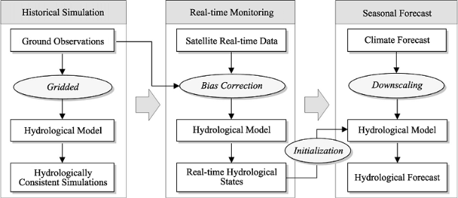
Figure 1 The configuration of hydrological monitoring and seasonal forecast framework for China
The statistical-based hydrological forecast is mostly based on the long-term time series and limited to the single-variable outcome (e.g., streamflow). One common way is to regress seasonal streamflow volume on the corresponding hydro-climatic predictors (e.g., precipitation, temperature, and SWE) (Garen, 1992; Kwon et al., 2009; Pagano et al., 2009). Some other statistical methods, such as the independent component analysis (Westra et al., 2008), the nonparametric statistical analysis (Robertson and Wang, 2012; Di et al., 2014; Singh and Cui, 2015), were also largely employed for seasonal streamflow forecast. However, the statistical-based forecast model are usually trained with multi-decadal time series, leaving it hard to capture the transient relationship between the climatic predictors and predictand (e.g., streamflow), particularly in the context of a changing climate and non-stationary hydrology. Furthermore, volume of streamflow was simply recognized as the function of indicative predictors (e.g., precipitation, temperature, and streamflow) in this forecast approach, without describing the physical processes of the terrestrial water cycle.
Along with the advance in land surface hydrological models, the physical model-based seasonal forecast has been becoming popular. One example is the so-called ESP approach, wherein the climate forcings during the forecast period are taken from an ensemble of previous years for the same period (Day, 1985). Accordingly, the forecast skill of ESP is solely dependent on the knowledge of ICs such as initial snow and soil moisture. As a primary land surface moisture storage term, snowpack affects seasonal hydrological forecast skill over the snow-fed river basins (Maurer et al., 2004), particularly over those high-latitude (Yossef et al., 2013; Shukla et al., 2013) and mountainous regions (Staudinger and Seibert, 2014). For those regions with little snow impact, ESP forecast skill is mostly controlled by the antecedent soil moisture (Koster et al., 2010). Particularly, for the regions characterized with dry climate regime, the dominance of soil moisture condition can last for 3-month (Yuan et al., 2013a; Yang et al., 2014). This may be because the precipitation amount and variation are both low in the dry regions, leading to the weak influence of precipitation to the hydrological estimates (e.g., runoff and soil moisture) (Mo and Lettenmaier, 2014). In addition, the influence of ICs to seasonal hydrological predictability has an obvious interannual variability, e.g., with more important role in neutral years than in El Niño-Southern Oscillation (ENSO)-dominant years (Yuan et al., 2013b; Sinha and Sankarasubramanian, 2013). Through an assessment during the hydrological extremes, the role of ICs differs on the phase of hydrological extremes. Specifically, the knowledge of ICs during the drought development phase generally outweighs that during predicting the onset of drought (Thober et al., 2015).
The ESP approach was firstly implemented operationally by the National Weather Services (NWS) River Forecast Centers (Day, 1985), and was then augmented by relating the seasonal streamflow forecasts with large-scale remote climate indices (Hamlet and Lettenmaier, 1999; Werner et al., 2004, 2005; Wang et al., 2011b; van Dijk et al., 2013). Subsequently, a test bed for seasonal hydrological forecasting approach was proposed to predict soil moisture and runoff up to several months over the U.S., wherein the historical simulation (used to form a long-term climatology), the real-time monitoring (used to provide the real-time accurate forecast ICs), and the seasonal forecast (used to predict the hydrological outputs out to several months) were integrated within an operational system (Wood and Lettenmaier, 2006).
In addition to ICs, the strong ocean-atmosphere teleconnection, such as ENSO associated with the change in SST anomalies and winds in the tropical Pacific, is another primary source of seasonal hydrological predictability (Smith et al., 2012). The linkage of climate indices with seasonal hydrological predictability has been quantified over multiple river basins (Lan et al., 2003; Maurer et al., 2004; Bierkens et al., 2009; Liu et al., 2012; van Dijk et al., 2013). With the improved representation of such large-scale climate phenomena (e.g., ENSO) in coupled atmosphere-ocean general circulation models (CGCMs) (Barnston et al., 2012), predicting seasonal hydrology based on CGCMs has received considerable attentions over the recent years (Luo and Wood, 2008; Yuan et al., 2015a). Practically, one challenge for such CGCM-based forecast approach is that the spatial resolution of seasonal CFs is too coarse to be directly used as hydrological model inputs. This inspired many researchers to explore the downscaling methodologies, such as the unconditional Bias Correction and Spatial Downscaling (BCSD) method (Wood et al., 2002) and the conditional the Bayesian downscaling method (Luo et al., 2007). Aside from the statistical downscaling scheme, the dynamical downscaling method, which employs the advantage of regional climate models (RCMs) (i.e., with satisfactory representation of local climate response) to effectively reduce the CGCM forecast errors at daily-to-seasonal scales (Yuan and Liang, 2011), is being under explored as well. For example, the Multi-RCM Ensemble Downscaling (MRED) project was initiated by Climate Prediction Program for the Americas (CPPA) to conduct the multi-decadal ensemble downscaling experiments during the cold seasons, in which multiple RCMs were merged with National Centers for Environmental Prediction (NCEP) Climate Forecast System (CFS) (Yuan and Liang, 2011; De Sales and Xue, 2013; Shukla and Lettenmaier, 2013). The CGCM climate outputs, after appropriate downscaling procedures, can be directly used to force the hydrological model for seasonal prediction of hydrological fields. Previous studies have assessed the CGCM-based seasonal forecast skill for a multi-decadal hindcast period (e.g., Wood et al., 2005; Luo and Wood, 2008; Mo et al., 2012; Yuan et al., 2013b; Bastola et al., 2013; Mo and Lettenmaier, 2014), and broadly indicate that CGCM-based hydrological forecast skill has marginal improvement relative to ESP beyond 1 month. This suggests much more efforts are needed to improve the CGCMs’ predictive skill, especially for those variables relevant to hydrology.
A CGCM-based drought monitoring and seasonal forecasting system, based on the seasonal climate forecasts from a newly developed CGCM (CFSv2; Saha et al., 2014), the Bayesian downscaling scheme and historic observations from the Phase 2 of the North American Land Data Assimilation system (NLDAS-2; Xia et al., 2012), were developed to carry out a Drought Forecast Analysis in support of the U.S. Seasonal Drought Outlook (Luo and Wood, 2007). In addition to the USA, similar experimental forecasting systems were developed over other continents like Europe (European Drought Observatory) (Vogt et al., 2011) and Africa (Yuan et al., 2013a; Sheffield et al., 2014), as well as to the global scale (Yuan et al., 2015b).

5 Hydrological monitoring and forecasting practices in China

Over the past few decades, China has experienced frequent hydrological extremes (e.g., drought and flood). In this context, numerous hydrological monitoring and seasonal forecast practices have been put in place for risk coping and reduction. Primarily, the Bureau of Hydrology (BoH) established a comprehensive station-based monitoring network over China, which includes over 90,000 hydrometric stations (wherein there are over 3200 hydrological stations), to provide the real-time measurement of river flow regime. Subsequently, the corresponding operational systems, such as Hydrological Information Inquiry System (HIIS) and Information Service System (ISS), were extensively implemented to provide official information services for water resource managers and decision-makers (http://www.hydroinfo. gov.cn/). In addition to the BoH, the National Climate Center (NCC) at CMA initiated a drought monitoring platform to provide insight into the real-time meteorological drought diagnosis over China (http://cmdp.ncc.cma.gov.cn/en/). Recently, a China Drought Meteorology Scientific Research Project has been launched since 2015, aiming at improving the monitoring and understanding of droughts from meteorological perspective to those for agricultural and hydrological applications. The project is also targeted at developing a refined drought early warning system in northern China based on multiple global climate forecast models (Ma et al., 2015) and physical hydrologic models (Yuan et al., 2015b).
The short-term flood forecast, based on the numerical weather prediction (NWP) and hydrological models, is also an active area with significant attentions in China (Lu et al., 2008; Bao et al., 2012). The BoH has implemented a universal flood forecasting system software platform, China National Flood Forecasting System (CNFFS), towards an effective flood control (Liu and Zhang, 2005; Zhang and Liu, 2006). As for seasonal hydrological forecast, the ESP scheme has been in wide use in China (Li et al., 2008; He et al., 2013; Yang et al., 2014), while little attention has been paid in terms of CGCM-based forecast, except for a recent work focusing on the global major river basins (Yuan et al., 2015b). To this end, a hydrological model-based experimental hydrological monitoring and seasonal forecast framework for China was proposed (Figure 1). The framework seamlessly integrates the gauge-based historical simulation (Zhang et al., 2014), satellite-aided real-time monitoring (Zhang and Tang, 2015), CFSv2-based seasonal forecast into an operational system. In addition, an experimental seasonal hydrological forecasting system is being developed over Yellow River Basin based on a well-calibrated hydrologic model and multiple CGCMs.

6 Summary and future perspectives

Over the past few decades, the hydrological monitoring technique has been largely improved along with the advances in remote sensing and numerical models. On one hand, many hydrological variables become acquirable in a real-time manner via automatic ground-based stations or satellite remote sensing. On the other hand, the calibrated hydrological model, being assisted by station and satellite data, has been demonstrated to provide reliable hydrological fluxes and states in real-time manner. A few satellite-assisted hydrological monitoring systems have been implemented across different scales and used for flood/drought diagnosis. Notably, there are considerable uncertainties residing in data generation and processing, which promotes the development of various mathematical methods to reduce or quantify such errors. While great progress has been achieved for hydrological monitoring, continued efforts are still in urgent need to improve the accuracy of measurement, such as by expanding the in-situ networks, and by improving the in-situ measurement techniques and satellite retrieve algorithms. In addition, it is of intense desire to incorporate the human-induced impacts (e.g., land cover, irrigation, and groundwater pumping) into land surface hydrological models by improving model parameterization scheme, with intent to simulate more realistic hydrological conditions.
The physical model-based hydrological forecast is becoming popular and implemented in two typical ways: (1) ESP-based framework that employs the ensemble of historical observations as the inputs of hydrological model and (2) climate model-based framework that drives the hydrological model with the downscaled outputs of climate forecast model. To date, considerable efforts have been devoted to assessing the reliability of seasonal hydrological prediction, such as by quantifying the contribution of initial conditions (ICs) and climate forecasts (CFs) to seasonal hydrological predictability. Concurrently, a few operational hydrological seasonal forecast systems, with the aid of real-time monitoring of ICs, the climate model outputs, and the appropriate statistical or dynamical downscaling methods, were explored using either single (climate and hydrological) model or multiple models. To better constrain the ICs, data assimilation technique is essential to improve the mode-derived prediction through blending the in-situ/satellite observations into hydrological monitoring.
In China, the BoH has made a large amount of hydrological monitoring and forecasting practices, for example, establishing the river regime monitoring network and short-term flood warning system across China. In contrast, the area of seasonal hydrological forecasts, especially that based on the climate model outputs, is still in infancy. In following, it should put more focus on the CGCM-based seasonal hydrological forecasts over China, in terms of quantifying the source of hydrological predictability within a consistent diagnosis framework, developing an operational seasonal forecast system in support of China Seasonal Drought Outlook, and assimilating the in-situ measurement of ICs into the operation system to reduce the uncertainties associated with the ICs.
Although many practices have been made for seasonal hydrological forecasts, many challenges still exist and need to be further addressed in near future. Firstly, it is essential to combine the statistical-based and the physical-based models, with intent to create a multimodel ensemble that is characterized with the largest model diversity. Secondly, further efforts are needed to develop a hydrological forecast system that seamlessly integrates the weather forecast and climate forecast (Yuan et al., 2014). This will greatly benefit integrating the achievement in short-term flood forecast and seasonal drought prediction. Furthermore, substantial attentions should be paid on investigating how to effectively incorporate human interventions into the operational monitoring and forecast system in the purpose of yielding more realistic hydrological conditions. Lastly, the final purpose for hydrological monitoring and seasonal forecasting is to provide useful guidance for the end users. Thus, to explore the solutions, which can effectively convert the probabilistic forecast consequences into the understandable and valuable information for the decision-makers (Demargne et al., 2014), is perhaps of equal to or greater importance than the development of such operational systems.

The authors have declared that no competing interests exist.

1
Ajami N K, Duan Q, Sorooshian S, 2007. An integrated hydrologic Bayesian multimodel combination framework: Confronting input, parameter, and model structural uncertainty in hydrologic prediction.Water Resources Research, 43: W01403.

2
Andreadis K M, Clark E A, Wood A Wet al., 2005. Twentieth-century drought in the conterminous United States.Journal of Hydrometeorology, 6(6): 985-1001.Droughts can be characterized by their severity, frequency and duration, and areal extent. Depth09 rea09 uration analysis, widely used to characterize precipitation extremes, provides a basis for the evaluation of drought severity when storm depth is replaced by an appropriate measure of drought severity. Gridded precipitation and temperature data were used to force a physically based macroscale hydrologic model at 1/200° spatial resolution over the continental United States, and construct a drought history from 1920 to 2003 based on the model-simulated soil moisture and runoff. A clustering algorithm was used to identify individual drought events and their spatial extent from monthly summaries of the simulated data. A series of severity09 rea09 uration (SAD) curves were constructed to relate the area of each drought to its severity. An envelope of the most severe drought events in terms of their SAD characteristics was then constructed. The results show that (a) the droughts of the 1930s and 1950s were the most severe of the twentieth century for large areas; (b) the early 2000s drought in the western United States is among the most severe in the period of record, especially for small areas and short durations; (c) the most severe agricultural droughts were also among the most severe hydrologic droughts, however, the early 2000s western U.S. drought occupies a larger portion of the hydrologic drought envelope curve than does its agricultural companion; and (d) runoff tends to recover in response to precipitation more quickly than soil moisture, so the severity of hydrologic drought during the 1930s and 1950s was dampened by short wet spells, while the severity of the early 2000s drought remained high because of the relative absence of these short-term phenomena.

DOI

3
Andreadis K M, Lettenmaier D P, 2006. Assimilating remotely sensed snow observations into a macroscale hydrology model.Advances in Water Resources, 29: 872-886.lt;h2 class="secHeading" id="section_abstract">Abstract</h2><p id="">Accurate forecasting of snow properties is important for effective water resources management, especially in mountainous areas like the western United States. Current model-based forecasting approaches are limited by model biases and input data uncertainties. Remote sensing offers an opportunity for observation of snow properties, like areal extent and water equivalent, over larger areas. Data assimilation provides a framework for optimally merging information from remotely sensed observations and hydrologic model predictions. An ensemble Kalman filter (EnKF) was used to assimilate remotely sensed snow observations into the variable infiltration capacity (VIC) macroscale hydrologic model over the Snake River basin. The snow cover extent (SCE) product from the moderate resolution imaging spectroradiometer (MODIS) flown on the NASA Terra satellite was used to update VIC snow water equivalent (SWE), for a period of four consecutive winters (1999&ndash;2003). A simple snow depletion curve model was used for the necessary SWE&ndash;SCE inversion. The results showed that the EnKF is an effective and operationally feasible solution; the filter successfully updated model SCE predictions to better agree with the MODIS observations and ground surface measurements. Comparisons of the VIC SWE estimates following updating with surface SWE observations (from the NRCS SNOTEL network) indicated that the filter performance was a modest improvement over the open-loop (un-updated) simulations. This improvement was more evident for lower to middle elevations, and during snowmelt, while during accumulation the filter and open-loop estimates were very close on average. Subsequently, a preliminary assessment of the potential for assimilating the SWE product from the advanced microwave scanning radiometer (AMSR-E, flown on board the NASA Aqua satellite) was conducted. The results were not encouraging, and appeared to reflect large errors in the AMSR-E SWE product, which were also apparent in comparisons with SNOTEL data.</p>

DOI

4
Bao H, Zhao L, 2012. Flood forecast of Huaihe River based on TIGGE Ensemble Prediction.Journal of Hydraulic Engineering, 43(2): 216-224.An ensemble flood forecasting model,based on the THORPEX Interactive Grand Global Ensemble(TIGGE) ensemble weather predictions was developed for flood forecast and early flood warning of Huaihe River,with the effects of flood diversion and retarding areas taken into account.The combination of numerical weather predictions(NWP) with flood forecasting system can increase the forecast lead time.A single NWP forecast,however,is insufficient as it involves considerable non-predictable uncertainties and can lead to a lot of false or missed warnings.Weather forecasts using ensemble predictions implemented on catchment hydrology can provide significantly improved flood forecast and early flood warning.In this paper,the upper reaches of the Huaihe River,upstream of the Lutaizi Hydrological Station,was taken as a test case.The hydrologic-hydraulic coupled model was applied for flood forecasting driven by ensemble weather predictions based on the TIGGE database(CMC 15members,ECWMF 51members,UKMO 24member,NCEP 15members) in the period of 2007 flood seasons.The Xinanjiang model was used for the hydrological rainfall-runoff modeling.One-dimension hydraulic model was applied for channel flood routing.A probabilistic discharge and flood inundation forecast was provided as the end product to study the potential benefits of using the TIGGE ensemble forecasts.The results demonstrated satisfactory flood forecasting with clear signals of probability of floods up to 72~120 hours in advance,and showed that TIGGE ensemble forecasts is a promising tool to early flood warning inundation,comparable with that based on rain gauge observation.

5
Barnston A G, Tippett M K, L’Heureux M Let al., 2012. Skill of real-time seasonal ENSO model predictions during 2002-11: Is our capability increasing?Bulletin of the American Meteorological Society, 93: 631-651.

6
Bastola S, Misra V, Li H, 2013. Seasonal hydrological forecasts for watersheds over the southeastern United States for the boreal summer and fall seasons.Earth Interactions, 17: 1-22.Abstract The authors evaluate the skill of a suite of seasonal hydrological prediction experiments over 28 watersheds throughout the southeastern United States (SEUS), including Florida, Georgia, Alabama, South Carolina, and North Carolina. The seasonal climate retrospective forecasts [the Florida Climate Institute lorida State University Seasonal Hindcasts at 50-km resolution (FISH50)] is initialized in June and integrated through November of each year from 1982 through 2001. Each seasonal climate forecast has six ensemble members. An earlier study showed that FISH50 represents state-of-the-art seasonal climate prediction skill for the summer and fall seasons, especially in the subtropical and higher latitudes. The retrospective prediction of streamflow is based on multiple calibrated rainfall unoff models. The hydrological models are forced with rainfall from FISH50, (quantile based) bias-corrected FISH50 rainfall (FISH50_BC), and resampled historical rainfall observations based on matching observed analogs of forecasted quartile seasonal rainfall anomalies (FISH50_Resamp). The results show that direct use of output from the climate model (FISH50) results in huge biases in predicted streamflow, which is significantly reduced with bias correction (FISH50_BC) or by FISH50_Resamp. On a discouraging note, the authors find that the deterministic skill of retrospective streamflow prediction as measured by the normalized root-mean-square error is poor compared to the climatological forecast irrespective of how FISH50 (e.g., FISH50_BC, FISH50_Resamp) is used to force the hydrological models. However, our analysis of probabilistic skill from the same suite of retrospective prediction experiments reveals that, over the majority of the 28 watersheds in the SEUS, significantly higher probabilistic skill than climatological forecast of streamflow can be harvested for the wet/dry seasonal anomalies (i.e., extreme quartiles) using FISH50_Resamp as the forcing. The authors contend that, given the nature of the relatively low climate predictability over the SEUS, high deterministic hydrological prediction skills will be elusive. Therefore, probabilistic hydrological prediction for the SEUS watersheds is very appealing, especially with the current capability of generating a comparatively huge ensemble of seasonal hydrological predictions for each watershed and for each season, which offers a robust estimate of associated forecast uncertainty.

DOI

7
Below R, Grover-Kopec E, Dilley M, 2007. Documenting drought-related disasters: A global reassessment.The Journal of Environment & Development, 16: 328-344.Until recently, drought events were inconsistently recorded in EM-DAT. Problems included inconsistent establishment of start and end dates, misattribution of losses, and difficulties with handling multiyear and multicountry events, mostly arising from the slow onset, spatially extensive, prolonged, and complex nature of drought. This article summarizes the procedures and results of a comprehensive review of 807 drought and 76 famine entries from 1900 to 2004. A standardized methodology has been developed for characterizing drought events that is consistent with all other natural hazards recorded in the database. The result consists in a reduction of 56% from the original number of drought entries, a 20% increase in the number of deaths and a 35% increase in economic losses. Based on the revised data, more than half of all deaths associated with natural hazards are now classified as drought related, and only floods rank higher in terms of the number of people affected.

DOI

8
Beven K J, Binley A M, 1992. The future of distributed models: model calibration and uncertainty prediction.Hydrological Processes, 6: 279-298.

9
Bierkens M, van Beek L, 2009: Seasonal predictability of European discharge: NAO and hydrological response time.Journal of Hydrometeorology, 10: 953-968.Abstract In this paper the skill of seasonal prediction of river discharge and how this skill varies between the branches of European rivers across Europe is assessed. A prediction system of seasonal (winter and summer) discharge is evaluated using 1) predictions of the average North Atlantic Oscillation (NAO) index for the coming winter based on May SST anomalies of the North Atlantic; 2) a global-scale hydrological model; and 3) 40-yr European Centre for Medium-Range Weather Forecasts Re-Analysis (ERA-40) data. The skill of seasonal discharge predictions is investigated with a numerical experiment. Also Europe-wide patterns of predictive skill are related to the use of NAO-based seasonal weather prediction, the hydrological properties of the river basin, and a correct assessment of initial hydrological states. These patterns, which are also corroborated by observations, show that in many parts of Europe the skill of predicting winter discharge can, in theory, be quite large. However, this achieved skill mainly comes from knowing the correct initial conditions of the hydrological system (i.e., groundwater, surface water, soil water storage of the basin) rather than from the use of NAO-based seasonal weather prediction. These factors are equally important for predicting subsequent summer discharge.

DOI

10
Clark M P, Rupp D E, Woods R Aet al., 2008. Hydrological data assimilation with the ensemble Kalman filter: Use of streamflow observations to update states in a distributed hydrological model.Advances in Water Resources, 31: 1309-1324.<h2 class="secHeading" id="section_abstract">Abstract</h2><p id="">This paper describes an application of the ensemble Kalman filter (EnKF) in which streamflow observations are used to update states in a distributed hydrological model. We demonstrate that the standard implementation of the EnKF is inappropriate because of non-linear relationships between model states and observations. Transforming streamflow into log space before computing error covariances improves filter performance. We also demonstrate that model simulations improve when we use a variant of the EnKF that does not require perturbed observations. Our attempt to propagate information to neighbouring basins was unsuccessful, largely due to inadequacies in modelling the spatial variability of hydrological processes. New methods are needed to produce ensemble simulations that both reflect total model error and adequately simulate the spatial variability of hydrological states and fluxes.</p>

DOI

11
Day G N, 1985. Extended streamflow forecasting using NWSRFS. Journal of Water Resources Planning and Management (ASCE), 111: 157-170.

12
De Lannoy G, Reichle R H, Arsenault K Ret al., 2012. Multiscale assimilation of Advanced Microwave Scanning Radiometer-EOS snow water equivalent and Moderate Resolution Imaging Spectroradiometer snow cover fraction observations in northern Colorado.Water Resources Research, 48: W01522.

13
De Lannoy G, Reichle R H, Houser P Ret al., 2010. Satellite-scale snow water equivalent assimilation into a high-resolution land surface model.Journal of Hydrometeorology, 11: 352-369.Four methods based on the ensemble Kalman filter (EnKF) are tested to assimilate coarse-scale (25 km) snow water equivalent (SWE) observations (typical of passive microwave satellite retrievals) into finescale (1 km) land model simulations. Synthetic coarse-scale observations are assimilated directly using an observation operator for mapping between the coarse and fine scales or, alternatively, after disaggregation (regridding) to the finescale model resolution prior to data assimilation. In either case, observations are assimilated either simultaneously or independently for each location. Results indicate that assimilating disaggregated finescale observations independently (method 1D-F1) is less efficient than assimilating a collection of neighboring disaggregated observations (method 3D-Fm). Direct assimilation of coarse-scale observations is superior to a priori disaggregation. Independent assimilation of individual coarse-scale observations (method 3D-C1) can bring the overall mean analyzed field close to the truth, but does not necessarily improve estimates of the finescale structure. There is a clear benefit to simultaneously assimilating multiple coarse-scale observations (method 3D-Cm) even as the entire domain is observed, indicating that underlying spatial error correlations can be exploited to improve SWE estimates. Method 3D-Cm avoids artificial transitions at the coarse observation pixel boundaries and can reduce the RMSE by 60% when compared to the open loop in this study.

DOI

14
De Sales F, Xue Y, 2013. Dynamic downscaling of CFS winter seasonal simulations with the UCLAETA regional climate model over the United States.Climate Dynamics, 41: 255-275.This study evaluates the UCLA-ETA regional model's dynamic downscaling ability to improve the National Center for Environmental Prediction Climate Forecast System (NCEP CFS), winter season predictions over the contiguous United States (US). Spatial distributions and temporal variations of seasonal and monthly precipitation are the main focus. A multi-member ensemble means of 22 winters from 1982 through 2004 are included in the study. CFS over-predicts the precipitation in eastern and western US by as much as 45 and 90 % on average compared to observations, respectively. Dynamic downscaling improves the precipitation hindcasts across the domain, except in the southern States, by substantially reducing the excessive precipitation produced by the CFS. Average precipitation root-mean-square error for CFS and UCLA-ETA are 1.5 and 0.9 mm day(-1), respectively. In addition, downscaling improves the simulation of spatial distribution of snow water equivalent and land surface heat fluxes. Despite these large improvements, the UCLA-ETA's ability to improve the inter-annual and intra-seasonal precipitation variability is not clear, probably because of the imposed CFS' lateral boundary conditions. Preliminary analysis of the cause for the large precipitation differences between the models reveals that the CFS appears to underestimate the moisture flux convergence despite producing excessive precipitation amounts. Additionally, the comparison of modeled monthly surface sensible and latent heat fluxes with Global Land Data Assimilation System land data set shows that the CFS incorrectly partitioned most of surface energy into evaporation, unlike the UCLA-ETA. These findings suggest that the downscaling improvements are mostly due to a better representation of land-surface processes by the UCLA-ETA. Sensitivity tests also reveal that higher-resolution topography only played a secondary role in the dynamic downscaling improvement.

DOI

15
Demargne J, 2014. The science of NOAA’s operational hydrologic ensemble forecast service.Bulletin of the American Meteorological Society, 95: 79-98.

16
Di C L, Yang X H, Wang X C, 2014. A four-stage hybrid model for hydrological time series forecasting.PLoS One, 9(8): e104663.Hydrological time series forecasting remains a difficult task due to its complicated nonlinear, non-stationary and multi-scale characteristics. To solve this difficulty and improve the prediction accuracy, a novel four-stage hybrid model is proposed for hydrological time series forecasting based on the principle of enoising, decomposition and ensemble. The proposed model has four stages, i.e., denoising, decomposition, components prediction and ensemble. In the denoising stage, the empirical mode decomposition (EMD) method is utilized to reduce the noises in the hydrological time series. Then, an improved method of EMD, the ensemble empirical mode decomposition (EEMD), is applied to decompose the denoised series into a number of intrinsic mode function (IMF) components and one residual component. Next, the radial basis function neural network (RBFNN) is adopted to predict the trend of all of the components obtained in the decomposition stage. In the final ensemble prediction stage, the forecasting results of all of the IMF and residual components obtained in the third stage are combined to generate the final prediction results, using a linear neural network (LNN) model. For illustration and verification, six hydrological cases with different characteristics are used to test the effectiveness of the proposed model. The proposed hybrid model performs better than conventional single models, the hybrid models without denoising or decomposition and the hybrid models based on other methods, such as the wavelet analysis (WA)-based hybrid models. In addition, the denoising and decomposition strategies decrease the complexity of the series and reduce the difficulties of the forecasting. With its effective denoising and accurate decomposition ability, high prediction precision and wide applicability, the new model is very promising for complex time series forecasting. This new forecast model is an extension of nonlinear prediction models.

DOI PMID

17
Döll P, Fiedler K, Zhang J, 2009. Global-scale analysis of river flow alterations due to water withdrawals and reservoirs.Hydrology and Earth System Sciences, 13: 2413-2432.Global-scale information on natural river flows and anthropogenic river flow alterations is required to identify areas where aqueous ecosystems are expected to be strongly degraded. Such information can support the identification of environmental flow guidelines and a sustainable water management that balances the water demands of humans and ecosystems. This study presents the first global assessment of the anthropogenic alteration of river flow regimes, in particular of flow variability, by water withdrawals and dams/reservoirs. Six ecologically relevant flow indicators were quantified using an improved version of the global water model WaterGAP. WaterGAP simulated, with a spatial resolution of 0.5 degree, river discharge as affected by human water withdrawals and dams around the year 2000, as well as naturalized discharge without this type of human interference. Compared to naturalized conditions, long-term average global discharge into oceans and internal sinks has decreased by 2.7% due to water withdrawals, and by 0.8% due to dams. Mainly due to irrigation, long-term average river discharge and statistical low flow Q90 (monthly river discharge that is exceeded in 9 out of 10 months) have decreased by more than 10% on one sixth and one quarter of the global land area (excluding Antarctica and Greenland), respectively. Q90 has increased significantly on only 5% of the land area, downstream of reservoirs. Due to both water withdrawals and reservoirs, seasonal flow amplitude has decreased significantly on one sixth of the land area, while interannual variability has increased on one quarter of the land area mainly due to irrigation. It has decreased on only 8% of the land area, in areas downstream of reservoirs where consumptive water use is low. The impact of reservoirs is likely underestimated by our study as small reservoirs are not taken into account. Areas most affected by anthropogenic river flow alterations are the Western and Central USA, Mexico, the western coast of South America, the Mediterranean rim, Southern Africa, the semi-arid and arid countries of the Near East and Western Asia, Pakistan and India, Northern China and the Australian Murray-Darling Basin, as well as some Arctic rivers. Due to a large number of uncertainties related e.g. to the estimation of water use and reservoir operation rules, the analysis is expected to provide only first estimates of river flow alterations that should be refined in the future.

DOI

18
Duan Q, Schaake J, Andréassian Vet al., 2006. Model Parameter Estimation Experiment (MOPEX): An overview of science strategy and major results from the second and third workshops.Journal of Hydrology, 320: 3-17.

19
Duan Q, Sorooshian S, Gupta V, 1992. Effective and efficient global optimization for conceptual rainfall-runoff models.Water Resources Research, 28(4): 1015-1031.ABSTRACT The successful application of a conceptual rainfall-runoff (CRR) model depends on how well it is calibrated. Despite the popularity of CRR models, reports in the literature indicate that it is typically difficult, if not impossible, to obtain unique optimal values for their parameters using automatic calibration methods. Unless the best set of parameters associated with a given calibration data set can be found, it is difficult to determine how sensitive the parameter estimates (and hence the model forecasts) are to factors such as input and output data error, model error, quantity and quality of data, objective function used, and so on. Results are presented that establish clearly the nature of the multiple optima problem for the research CRR model SIXPAR. These results suggest that the CRR model optimization problem is more difficult than had been previously thought and that currently used local search procedures have a very low probability of successfully finding the optimal parameter sets. Next, the performance of three existing global search procedures are evaluated on the model SIXPAR. Finally, a powerful new global optimization procedure is presented, entitled the shuffled complex evolution (SCE-UA) method, which was able to consistently locate the global optimum of the SIXPAR model, and appears to be capable of efficiently and effectively solving the CRR model optimization problem.

DOI

20
Entekhabi D, Njoku E G, O’Neill P Eet al., 2010. The Soil Moisture Active Passive (SMAP) Mission.Proceedings of the IEEE, 98: 704-716.

21
Evensen G, 1997. Advanced data assimilation in strongly nonlinear dynamics.Monthly Weather Review, 125: 1342-1354.

22
Ferguson I M, Maxwell R M, 2012. Human impacts on terrestrial hydrology: Climate change versus pumping and irrigation.Environmental Research Letters, 7: 044022.Global climate change is altering terrestrial water and energy budgets, with subsequent impacts on surface and groundwater resources; recent studies have shown that local water management practices such as groundwater pumping and irrigation similarly alter terrestrial water and energy budgets over many agricultural regions, with potential feedbacks on weather and climate. Here we use a fully-integrated hydrologic model to directly compare effects of climate change and water management on terrestrial water and energy budgets of a representative agricultural watershed in the semi-arid Southern Great Plains, USA. At local scales, we find that the impacts of pumping and irrigation on latent heat flux, potential recharge and water table depth are similar in magnitude to the impacts of changing temperature and precipitation; however, the spatial distributions of climate and management impacts are substantially different. At the basin scale, the impacts on stream discharge and groundwater storage are remarkably similar. Notably, for the watershed and scenarios studied here, the changes in groundwater storage and stream discharge in response to a 2.5 temperature increase are nearly equivalent to those from groundwater-fed irrigation. Our results imply that many semi-arid basins worldwide that practice groundwater pumping and irrigation may already be experiencing similar impacts on surface water and groundwater resources to a warming climate. These results demonstrate that accurate assessment of climate change impacts and development of effective adaptation and mitigation strategies must account for local water management practices.

DOI

23
Fujii H, Koike T, Imaoka K, 2009. Improvement of the AMSR-E algorithm for soil moisture estimation by introducing a fractional vegetation coverage dataset derived from MODIS data.Journal of the Remote Sensing Society of Japan, 29(1): 282-292.

24
Gao H, Tang Q, Ferguson C Ret al., 2010. Estimating the water budget of major U.S. river basins via remote sensing.International Journal of Remote Sensing, 31: 3955-3978.Not Available

DOI

25
Garen D C, 1992. Improved techniques in regression-based streamflow volume forecasting. Journal of Water Resources Planning and Management (ASCE), 118: 654-670.Although multiple linear regression has been used for many years to predict seasonal streamflow volumes, typical practice has not realized the maximum accuracy obtainable from regression. Several techniques can help provide superior forecast accuracy using regression models: (1) Using only data known at forecast time; (2) principal components regression; (3) cross validation; and (4) systematic searching for optimal or near-optimal combinations of variables. Using no future data requires that a separate equation be used each month that forecasts are made rather than using a single equation throughout the forecast season. Consistency of month-to-month forecasts can be obtained by judicious selection of variables to maintain a high degree of similarity in the monthly equations. Results for the South Fork Boise River at Anderson Ranch Dam and other basins in the West indicate that these new regression procedures can give substantial improvements in forecast accuracy over existing procedures without sacrificing month-to-month forecast consistency.

DOI

26
Gerten D, Rost S, von Bloh Wet al., 2008. Causes of change in 20th century global river discharge.Geophysical Research Letters, 35: L20405.A global vegetation and hydrology model (LPJmL) was applied to quantify the contributions of changing precipitation, temperature, atmospheric COcontent, land use and irrigation to worldwide trends in 20th century river discharge (Q). Consistently with observations, Q decreased in parts of Africa, central/southern Asia and south-eastern Europe, and increased especially in parts of North America and western Asia. Based on the CRU TS2.1 climatology, total global Q rose over 1901-2002 (trend, 30.8 kma, equaling 7.7%), due primarily to increasing precipitation (individual effect, +24.7 kma). Global warming (-3.1), rising CO(+4.4), land cover changes (+5.9) and irrigation (-1.1) also had discernible effects. However, sign and magnitude of trends exhibited pronounced decadal variability and differed among precipitation forcing datasets. Since recent trends in these and other drivers of Q are mainly anthropogenic, we conclude that humans exert an increasing influence on the global water cycle.

DOI

27
Glahn H R, Lowry D A, 1972. The use of Model Output Statistics (MOS) in objective weather forecasting. Journal of Applied Meteorology and Climatology, 11(8): 1203-1211.Model Output Statistics (MOS) is an objective weather forecasting technique which consists of determining a statistical relationship between a predictand and variables forecast by a numerical model at some projection time(s). It is, in effect, the determination of the `weather related' statistics of a numerical model. This technique, together with screening regression, has been applied to the prediction of surface wind, probability of precipitation, maximum temperature, cloud amount, and conditional probability of frozen precipitation. Predictors used include surface observations at initial time and predictions from the Subsynoptic Advection Model (SAM) and the Primitive Equation model used operationally by the National Weather Service. Verification scores have been computed, and, where possible, compared to scores for forecasts from other objective techniques and for the official forecasts. MOS forecasts of surface wind, probability of precipitation, and conditional probability of frozen precipitation are being disseminated by the National Weather Service over teletype and facsimile. It is concluded that MOS is a useful technique in objective weather forecasting.

DOI

28
Haddeland I, Clark D B, Franssen Wet al., 2011. Multimodel estimate of the global terrestrial water balance: Setup and first results.Journal of Hydrometeorology, 12: 869-884.Six land surface models and five global hydrological models participate in a model intercomparison project [Water Model Intercomparison Project (WaterMIP)], which for the first time compares simulation results of these different classes of models in a consistent way. In this paper, the simulation setup is described and aspects of the multimodel global terrestrial water balance are presented. All models were run at 0.5 degrees spatial resolution for the global land areas for a 15-yr period (1985-99) using a newly developed global meteorological dataset. Simulated global terrestrial evapotranspiration, excluding Greenland and Antarctica, ranges from 415 to 586 mm yr(-1) (from 60 000 to 85 000 km(3) yr(-1)), and simulated runoff ranges from 290 to 457 mm yr(-1) (from 42 000 to 66 000 km(3) yr(-1)). Both the mean and median runoff fractions for the land surface models are lower than those of the global hydrological models, although the range is wider. Significant simulation differences between land surface and global hydrological models are found to be caused by the snow scheme employed. The physically based energy balance approach used by land surface models generally results in lower snow water equivalent values than the conceptual degree-day approach used by global hydrological models. Some differences in simulated runoff and evapotranspiration are explained by model parameterizations, although the processes included and parameterizations used are not distinct to either land surface models or global hydrological models. The results show that differences between models are a major source of uncertainty. Climate change impact studies thus need to use not only multiple climate models but also some other measure of uncertainty (e.g., multiple impact models).

DOI

29
Hamlet A F, Lettenmaier D P, 1999. Columbia River streamflow forecasting based on ENSO and PDO climate signals. Journal of Water Resources Planning and Management (ASCE), 125(6): 333-341.

30
Han E, Crow W T, Holmes Tet al., 2014. Benchmarking a Soil Moisture Data Assimilation System for Agricultural Drought Monitoring.Journal of Hydrometeorology, 15: 1117-1134.Not Available

DOI

31
He X, Zhao T, Yang D, 2013. Prediction of monthly inflow to the Danjiangkou reservoir by distributed hydrological model and hydro-climatic teleconnections.Journal of Hydroelectric Engineering, 32(3): 4-9.Watershed initial conditions and future meteorological prediction are two important aspects that affect long-term streamflow prediction.This study combines a distributed hydrological model and hydro-climatic teleconnection analysis to predict the monthly streamflow of the Han River.We first applied a random forests model to analyze hydro-climatic teleconnections for selecting the dominant climate factors,and then selected future possible precipitation scenarios from the historical meteorological records based on similarity of the selected climate factors.The distributed hydrological model was used to obtain initial conditions and predict the long-term streamflow using the selected meteorological scenarios.Results show that this random forests model is effective for analyzing hydro-climatic teleconnections,and the distributed hydrological model could do rational prediction of long-term streamflow by using appropriate initial conditions and meteorological scenarios.

32
Hirabayashi Y, Kanae S, Emori Set al., 2008. Global projections of changing risks of floods and droughts in a changing climate.Hydrological Sciences Journal, 53(4): 754-772.Simulated daily discharge derived from a relatively high-resolution (approximately 1.1-degree) general circulation model was used to investigate future projections of extremes in river discharge under global warming. The frequency of floods was projected to increase over many regions, except those including North America and central to western Eurasia. The drought frequency was projected to increase globally, while regions such as northern high latitudes, eastern Australia, and eastern Eurasia showed a decrease or no significant changes. Changes in flood and drought are not explained simply by changes in annual precipitation, heavy precipitation, or differences between precipitation and evapotranspiration. Several regions were projected to have increases in both flood frequency and drought frequency. Such regions show a decrease in the number of precipitation days, but an increase in days with heavy rain. Several regions show shifts in the flood season from springtime snowmelt to the summer period of heavy precipitation.

DOI

33
Hirabayashi Y, Mahendran R, Koirala Set al., 2013. Global flood risk under climate change.Nature Climate Change, 3: 816-821.A warmer climate would increase the risk of floods(1). So far, only a few studies(2,3) have projected changes in floods on a global scale. None of these studies relied on multiple climate models. A few global studies(4,5) have started to estimate the exposure to flooding (population in potential inundation areas) as a proxy of risk, but none of them has estimated it in a warmer future climate. Here we present global flood risk for the end of this century based on the outputs of 11 climate models. A state-of-the-art global river routing model with an inundation scheme(6) was employed to compute river discharge and inundation area. An ensemble of projections under a new high-concentration scenario(7) demonstrates a large increase in flood frequency in Southeast Asia, Peninsular India, eastern Africa and the northern half of the Andes, with small uncertainty in the direction of change. In certain areas of the world, however, flood frequency is projected to decrease. Another larger ensemble of projections under four new concentration scenarios(7) reveals that the global exposure to floods would increase depending on the degree of warming, but interannual variability of the exposure may imply the necessity of adaptation before significant warming.

DOI

34
Hong Y, Adler R F, Hossain Fet al., 2007. A first approach to global runoff simulation using satellite rainfall estimation.Water Resources Research, 43: W08502.Motivated by the recent increasing availability of global remote sensing data for estimating precipitation and describing land surface characteristics, this note reports an approximate assessment of quasi-global runoff computed by incorporating satellite rainfall data and other remote sensing products in a relatively simple rainfall-runoff simulation approach: the Natural Resources Conservation Service (NRCS) runoff curve number (CN) method. Using an antecedent precipitation index (API) as a proxy of antecedent moisture conditions, this note estimates time-varying NRCS-CN values determined by the 5-day normalized API. Driven by a multiyear (1998-2006) Tropical Rainfall Measuring Mission Multi-satellite Precipitation Analysis, quasi-global runoff was retrospectively simulated with the NRCS-CN method and compared to Global Runoff Data Centre data at global and catchment scales. Results demonstrated the potential for using this simple method when diagnosing runoff values from satellite rainfall for the globe and for medium to large river basins. This work was done with the simple NRCS-CN method as a first-cut approach to understanding the challenges that lie ahead in advancing the satellite-based inference of global runoff. We expect that the successes and limitations revealed in this study will lay the basis for applying more advanced methods to capture the dynamic variability of the global hydrologic process for global runoff monitoring in real time. The essential ingredient in this work is the use of global satellite-based rainfall estimation.

DOI

35
Hou A Y, Kakar R K, Neeck Set al., 2014. The Global Precipitation Measurement Mission.Bulletin of the American Meteorological Society, 95: 701-722.

36
Houborg R, Rodell M, Li Bet al., 2012. Drought indicators based on model-assimilated Gravity Recovery and Climate Experiment (GRACE) terrestrial water storage observations.Water Resources Research, 48: W07525.

37
Hu S S, Zheng H X, Liu C Met al., 2012. Assessing the impacts of climate variability and human activities on streamflow in the water source area of Baiyangdian Lake.Acta Geographica Sinica, 67(1): 62-70. (in Chinese)As the largest wetland in the North China Plain (NCP), the Baiyangdian Lake plays an important role in maintaining water balance and ecological health of NCP. In the past few decades, the decreasing streamflow in the Baiyangdian Basin associated with climate variability and human activities has caused a series of water and eco-environmental issues. In this study, we quantified the impacts of climate variability and human activities on streamflow in the water source area of the Baiyangdian Lake, based on analyses of hydrologic changes of the upper Tanghe river catchment (a sub-basin of the Baiyangdian Basin) from 1960 to 2008. Climate elasticity method and hydrological modeling method were used to distinguish the effects of climate variability and human activities. The results showed that the annual streamflow decreased significantly (P>0.05) by 1.7 mm/a and an abrupt change was identified around the year 1980. The quantification results indicated that climate variations accounted for 38%-40% of decreased streamflow, while human activities accounted for 60%-62%. Therefore, the effect of human activities played a dominant role on the decline of the streamflow in the water source area of the Baiyangdian Lake. To keep the ecosystem health of the Baiyangdian Lake, we suggest that minimum ecological water demand and integrated watershed management should be guaranteed in the future.

DOI

38
Huang X, Xiao Q N, Barker D Met al., 2009. Four-dimensional variational data assimilation for WRF: Formulation and preliminary results.Monthly Weather Review, 137: 299-314.

39
Huffman G J, Bolvin D T, Nelkin E Jet al., 2007. The TRMM multisatellite precipitation analysis (TMPA): Quasi-global, multiyear, combined-sensor precipitation estimates at fine scales.Journal of Hydrometeorology, 8(1): 38-55.

40
Kavetski D, Franks S W, Kuczera G, 2002. Confronting input uncertainty in environmental modeling. In: Duan Q, Gupta H, Sorooshian S et al. (eds.). Calibration of Watershed Models. Water Science and Application Series 6, American Geophysical Union, Washington D. C.: 49-68.

41
Kim S, Liu Y Y, Johnson F Met al., 2015. A global comparison of alternate AMSR2 soil moisture products: Why do they differ?Remote Sensing of Environment, 161: 43-52.After examining the retrieval algorithms, it is hypothesized that four factors, namely, physical surface temperatures, surface roughness, vegetation and ground soil wetness conditions, may affect the quality of soil moisture retrievals. From the inter-comparisons at the global scale, the correlations of the two products highlight differences in the representation of the seasonal cycle of soil moisture, with negative correlations found for several regions. Correlations of the anomaly time series were generally strong (R>0.6) as a result of soil moisture sensitivity to external meteorological forcing and possibly also random noise in the satellite observations. Due to the inherent differences in spatial coverage and measurement scale of the COSMOS and satellite data, the comparisons in terms of correlation coefficients are the most reliable. It was found that both products show rapid decreases in correlation coefficients under low mean temperature (0.3) and highly wetted conditions. These findings are further supported by the bias and RMSE estimates which show that JAXA has relatively better performance under dry conditions while the bias and RMSE of LPRM are generally smaller than JAXA, when considered against the four variables. These results provide information on appropriate parameterizations and model selection for the retrieval algorithms and a future research direction to improve the quality by leveraging the strengths of the JAXA and LPRM algorithms. With these, when a multi-year dataset is available, there will be more confidence in defining the seasonal cycle and the data can be decomposed to identify the anomalies where the bias is not relevant.

DOI

42
Koster R D, Mahanama S, Livneh Bet al., 2010. Skill in streamflow forecasts derived from large-scale estimates of soil moisture and snow.Nature Geoscience, 3: 613-616.Seasonal predictions of streamflow can benefit from knowledge of the amounts of snow and other water present in a basin when the forecast is issued. In the American west, operational forecasts for spring-summer streamflow rely heavily on snow-water storage and are often issued at the time of maximum snow accumulation. However, forecasts issued earlier can also show skill, particularly if proxy information for soil moisture, such as antecedent rainfall, is also used as a predictor. Studies using multiple regression approaches and/or model-produced streamflows indeed suggest that information on soil moisture-a relatively underappreciated predictor-can improve streamflow predictions. Here, we quantify the relative contributions of early-season snow and soil moisture information to the skill of streamflow forecasts more directly and comprehensively: in a suite of land-modelling systems, we use the snow and soil moisture information both together and separately to derive seasonal forecasts. Our skill analysis reveals that early-season snow-water storage generally contributes most to skill, but the contribution of early-season soil moisture is often significant. In addition, we conclude that present-generation macroscale land-surface models forced with large-scale meteorological data can produce estimates of water storage in soils and as snow that are useful for basin-scale prediction.

DOI

43
Krishnamurti T N, Kishtawal C M, LaRow T Eet al., 1999. Improved weather and seasonal climate forecasts from multimodel superensemble.Science, 285: 1548-1550A method for improving weather and climate forecast skill has been developed. It is called a superensemble, and it arose from a study of the statistical properties of a low-order spectral model. Multiple regression was used to determine coefficients from multimodel forecasts and observations. The coefficients were then used in the superensemble technique. The superensemble was shown to outperform all model forecasts for multiseasonal, medium-range weather and hurricane forecasts. In addition, the superensemble was shown to have higher skill than forecasts based solely on ensemble averaging.

DOI PMID

44
Krzysztofowicz R, Sigrest A A, 1999. Calibration of probabilistic quantitative precipitation forecasts.Weather Forecast, 14(3): 427-442.Abstract From 1 August 1990 to 31 July 1995, the Weather Service Forecast Office in Pittsburgh prepared 6159 probabilistic quantitative precipitation forecasts. Forecasts were made twice a day for 24-h periods beginning at 0000 and 1200 UTC for two river basins. This is the first in a series of articles devoted to a comprehensive verification of these forecasts. The property verified herein is calibration: a match between forecast probabilities and empirical frequencies of events. Monthly time series of calibration statistics are analyzed to infer (i) trends in calibration over time, (ii) the forecasters’ skill in quantifying uncertainty, (iii) the adaptability of forecasters’ judgments to nonstationarities of the predictand, (iv) the possibility of reducing biases through dynamic recalibration, and (v) the potential for improving calibration through individualized training.

DOI

45
Kwon H-H, Brown C, Xu Ket al., 2009. Seasonal and annual maximum streamflow forecasting using climate information: Application to the Three Gorges Dam in the Yangtze River basin, China.Hydrological Sciences Journal, 54: 582-595.

46
Lan Y H, Ding Y J, Kang Eet al., 2003. The relationship between ENSO cycle and high and low-flow in the upper Yellow River.Journal of Geographical Sciences, 13(1): 105-111.<a name="Abs1"></a>Firstly, the hydrological and meteorological features of the upper reaches of the Yellow River above Tangnag are analyzed based on observation data, and effects of EI Nino and La Nina events on the high and low flow in the upper Yellow River are discussed. The results show El Nino and La Nina events possess consanguineous relationship with runoff in the upper Yellow River. As a whole, the probability of low flow occurrence in the upper Yellow River is relatively great along with the occurrence of El Nino event. Moreover, the flood in the upper Yellow River occurs frequently with the occurrence of La Nina event. Besides, the results also show dissimilarity of El Nino event occurring time exerts greater impact on high flow and low flow in the upper Yellow River, that is, the probability of drought will be greater in the same year if El Nino event occurs in spring, the high-flow may happen in this year if El Nino occurs in summer or autumn; the longer the continuous period of El Nino is, the lower the runoff in the upper Yellow River is.

DOI

47
Leng G, Huang M, Tang Qet al., 2013. Modeling the effects of irrigation on land surface fluxes and states over the conterminous United States: Sensitivity to input data and model parameters.Journal of Geophysical Research: Atmospheres, 118(17): 9789-9803.studies on irrigation impacts on land surface fluxes/states were mainly conducted as sensitivity experiments, with limited analysis of uncertainties from the input data and model irrigation schemes used. In this study, we calibrated and evaluated the performance of irrigation water use simulated by the Community Land Model version 4 (CLM4) against observations from agriculture census. We investigated the impacts of irrigation on land surface fluxes and states over the conterminous United States (CONUS) and explored possible directions of improvement. Specifically, we found large uncertainty in the irrigation area data from two widely used sources and CLM4 tended to produce unrealistically large temporal variations of irrigation demand for applications at the water resources region scale over CONUS. At seasonal to interannual time scales, the effects of irrigation on surface energy partitioning appeared to be large and persistent, and more pronounced in dry than wet years. Even with model calibration to yield overall good agreement with the irrigation amounts from the National Agricultural Statistics Service, differences between the two irrigation area data sets still dominate the differences in the interannual variability of land surface responses to irrigation. Our results suggest that irrigation amount simulated by CLM4 can be improved by calibrating model parameter values and accurate representation of the spatial distribution and intensity of irrigated areas. Furthermore, through a set of numerical experiments, the deficiency in the current parameterization is evaluated and a critical path forward to a realistic assessment of irrigation impacts using an earth system modeling approach is recommended.

DOI

48
Leng G, Huang M, Tang Qet al., 2014. Modeling the effects of groundwater-fed irrigation on terrestrial hydrology over the conterminous United States.Journal of Hydrometeorology, 15: 957-972.Human alteration of the land surface hydrologic cycle is substantial. Recent studies suggest that local water management practices including groundwater pumping and irrigation could significantly alter the quantity and distribution of water in the terrestrial system, with potential impacts on weather and climate through land atmosphere feedbacks. In this study, the authors incorporated a groundwater withdrawal scheme into the Community Land Model, version 4 (CLM4). To simulate the impact of irrigation realistically, they calibrated the CLM4 simulated irrigation amount against observations from agriculture censuses at the county scale over the conterminous United States. The water used for irrigation was then removed from the surface runoff and groundwater aquifer according to a ratio determined from the county-level agricultural census data. On the basis of the simulations, the impact of groundwater withdrawals for irrigation on land surface and subsurface fluxes were investigated. The results suggest that the impacts of irrigation on latent heat flux and potential recharge when water is withdrawn from surface water alone or from both surface and groundwater are comparable and local to the irrigation areas. However, when water is withdrawn from groundwater for irrigation, greater effects on the subsurface water balance are found, leading to significant depletion of groundwater storage in regions with low recharge rate and high groundwater exploitation rate. The results underscore the importance of local hydrologic feedbacks in governing hydrologic response to anthropogenic change in CLM4 and the need to more realistically simulate the two-way interactions among surface water, groundwater, and atmosphere to better understand the impacts of groundwater pumping on irrigation efficiency and climate.

DOI

49
Leng G Y, Tang Q H, Huang S Zet al., 2016. Assessments of joint hydrological extreme risks in a warming climate in China.International Journal of Climatology, 36: 1632-1642ABSTRACT Understanding how hydrological extremes would respond to global warming and its associated uncertainties is important for better designing mitigation and adaption strategies to cope with global change. Very few works have investigated the changes in future hydrological extremes and, especially, the more devastating joint hydrological extremes over China. In this article, two combinations of joint extremes [i.e. high runoff/high soil moisture (HRHS) and low runoff/low soil moisture (LRLS)] are designed for analysis. To derive the scenarios of hydrological conditions, the bias-corrected daily climate projections from five global circulation models (GCMs) under the historical and Representative Concentration Pathways 8.5 (RCP8.5) emission scenarios are used to drive the calibrated Variable Infiltration Capacity (VIC) model from 1951 to 2099 over China. Results show notable increase of occurrence of HRHS in Northeast China, LRLS in Northwest and South of China under 2 global warming. The spatial pattern of changes in joint extremes tends to remain stable with global temperature increase up to 3 . Compared with the individual extreme risk, joint extreme are much more concentrated in Northwest and South China and the magnitude of changes is several times larger. Larger areas experiencing changes are found when using lower standards of extreme definition. Because hydrological regime may change gradually in response to climate change, the threshold derived from present regime may lead to misrepresentation of extreme risk analysis. This was demonstrated by the ten times smaller magnitude of changes when adopting the updated transient threshold representing the changing hydrological regime, thus providing a low-boundary of potential changes in extremes. Our results highlight the importance of considering the changing hydrological regime in addition to choosing various levels of threshold for extreme definition in order to cover the full range of possible extreme changes in a warming climate.

DOI

50
Leng G Y, Tang Q H, Rayburg S, 2015. Climate change impacts on meteorological, agricultural and hydrological droughts in China.Global and Planetary Change, 126: 23-34.Bias corrected daily climate projections from five global circulation models (GCMs) under the RCP8.5 emission scenarios were fed into a calibrated Variable Infiltration Capacity (VIC) hydrologic model to project future hydrological changes in China. The standardized precipitation index (SPI), standardized runoff index (SRI) and standardized soil moisture index (SSWI) were used to assess the climate change impact on droughts from meteorological, agricultural, and hydrologic perspectives. Changes in drought severity, duration, and frequency suggest that meteorological, hydrological and agricultural droughts will become more severe, prolonged, and frequent for 2020-2049 relative to 1971-2000, except for parts of northern and northeastern China. The frequency of long-term agricultural droughts (with duration larger than 4 months) will increase more than that of short-term droughts (with duration less than 4 months), while the opposite is projected for meteorological and hydrological droughts. In extreme cases, the most prolonged agricultural droughts increased from 6 to 26 months whereas the most prolonged meteorological and hydrological droughts changed little. The most severe hydrological drought intensity was about 3 times the baseline in general whereas the most severe meteorological and agricultural drought intensities were about 2 times and 1.5 times the baseline respectively. For the prescribed local temperature increments up to 3 degrees C, increase of agricultural drought occurrence is predicted whereas decreases or little changes of meteorological and hydrological drought occurrences are projected for most temperature increments. The largest increase of meteorological and hydrological drought durations and intensities occurred when temperature increased by 1 degrees C whereas agricultural drought duration and intensity tend to increase consistently with temperature increments. Our results emphasize that specific measures should be taken by specific sectors in order to better mitigate future climate change associated with specific warming amounts. It is, however, important to keep in mind that our results may depend on the emission scenario, GCMs, impact model, time periods and drought indicators selected for analysis. (C) 2015 Elsevier B.V. All rights reserved.

DOI

51
Li H, Luo L, Wood E F, 2008. Seasonal hydrologic predictions of low-flow conditions over eastern USA during the 2007 drought.Atmospheric Science Letters, 9: 61-66.Abstract Top of page Abstract 1.Introduction 2.DMAPS he Princeton hydrologic nowcast and forecast system 3.Analyses of the 2007 hydrologic drought forecasts for Eastern USA 4.Summary Acknowledgements References A seasonal streamflow monitoring and forecasting component is implemented into the Drought Monitoring and Prediction System (Luo and Wood, 2007a ), which supplements the existing soil-moisture-based analysis framework by providing real-time streamflow monitoring and forecasting up to 6 months lead time. Evaluations were conducted over four basins in eastern USA to understand the forecast skill of the system for the extensive hydrologic droughts in 2007. Consistent with the agricultural drought forecasts reported by Luo and Wood ( 2007a ), the streamflow subsystem can forecast low-flow conditions for up to three months in advance, with Brier scores ranging from 0.10 to 0.49. Copyright 2008 Royal Meteorological Society

DOI

52
Li H, Luo L, Wood E F, Schaake J, 2009. The role of initial conditions and forcing uncertainties in seasonal hydrologic forecasting.Journal of Geophysical Research: Atmospheres, 114: D04114.A series of hydrologic forecasts with lead times up to 6 months are conducted to investigate the relative contributions of atmospheric forcing and hydrologic initial conditions (IC) to the overall errors in hydrologic forecasting during cold and warm seasons. These experiments are known as the ensemble streamflow prediction (ESP) and the reverse-ESP (R-ESP). Analysis of these hindcasts suggests that IC uncertainties outweigh forcing uncertainties thus dominating forecast errors in a short lead time up to about 1 month; at longer lead times, forcing uncertainties become a more important contributor. Further investigation shows that forecast errors at short lead times due to uncertain ICs are mainly determined by the prescribed IC variability, while the evolution of forecast errors due to imperfect atmospheric forcings mainly corresponds to the interannual variability of precipitation. With respect to difference in forecasts initialized in winter and summer times, ICs tend to have longer impacts on warm season forecasts than on cold season ones, due mainly to drier initial moisture state in the summer time. As far as the basin size is concerned, we find that the larger the basin, the stronger the impacts from ICs at short lead times. Small basins are more sensitive to forcing fields. Regardless of basin size, forcing uncertainties dominate relative forecast errors for long lead times. In order to see whether statistically downscaled forcing fields from dynamic climate models are more skillful than traditional ESP, we conducted additional ESP-type experiments using the statistically downscaled climate forecast system (CFS) fields to drive the hydrological model. In comparison to traditional ESP, the IC errors show a larger impact on the forecasts when forced by the CFS fields, which suggests that the latter contains more skill than the traditional ESP approach.

DOI

53
Li Q Z, Yan N N, Zhang F Fet al., 2010. Drought monitoring and its impacts assessment in Southwest China using remote sensing in the spring of 2010.Acta Geographica Sinica, 65(7): 771-780. (in Chinese)<p>The authors carried out drought monitoring and its impacts assessment in Southwest China using CCD and IRS data obtained from China-made satellite HJ-1 in the spring of 2010. The following techniques were proposed: 1) Drought monitoring using LST and NDVI derived from HJ-1 CCD and IRS; 2) Water resource assessment by comparison of water area sampled within the severe drought regions; 3) Effects of the drought on crops. Crop growing curves from time series MODIS NDVI were compared to assess the effects of drought on crop conditions, arable land area, crop planting proportion. Crop planting structure and area fraction of different drought grades were used to introduce crop area under the drought condition. A crop yield loss look-up table was also built-up based on field-experiment results digested from articles. The results showed that: i) the drought occurred mainly in Guangxi, Yunnan, Guizhou, Sichuan and Chongqing, especially in the northwest of Guangxi, central and northeast of Yunnan and the southwest of Guizhou. ii) the severe drought resulted in the withdrawal of surface water bodies, and more than 2/3 of water bodies disappeared. iii) Since last October, crop growing curves have presented obvious restrain due to the drought, Among the crops, winter wheat, seedrape and sugarcane has been greatly affected. There were about 9.13&times;10<sup>5</sup> hm<sup>2</sup> of winter wheat, 5.43&times;10<sup>5</sup> hm<sup>2</sup> of seedrape and 9.00&times;10<sup>5</sup> hm<sup>2</sup> of sugarcane suffering the drought, respectively. For winter wheat, there would be a damage of 8.3&times;10<sup>5</sup> t, and 13.7% of the total production of Chongqing, Sichuan, Guizhou and Yunnan, accounting for only 0.8% of the country. The damage would not do harm to the country's food security but will exert influence on regional grain supply-demand balance. The drought has also affected the nursery of autumn crops and transplant of rice.</p>

54
Li X, Liu S M, Xiao Qet al., 2013. Heihe Watershed Allied Telemetry Experimental Research (HiWATER): Scientific objectives and experimental design.Bulletin of the American Meteorological Society, 94: 1145-1160A major research plan entitled Integrated research on the ecohydrological process of the Heihe River Basin was launched by the National Natural Science Foundation of China in 2010. One of the key aims of this research plan is to establish a research platform that integrates observation, data management, and model simulation to foster twenty-first-century watershed science in China. Based on the diverse needs of interdisciplinary studies within this research plan, a program called the Heihe Watershed Allied Telemetry Experimental Research (HiWATER) was implemented. The overall objective of HiWATER is to improve the observability of hydrological and ecological processes, to build a world-class watershed observing system, and to enhance the applicability of remote sensing in integrated ecohydrological studies and water resource management at the basin scale. This paper introduces the background, scientific objectives, and experimental design of HiWATER. The instrumental setting and airborne mission plans are also outlined. The highlights are the use of a flux observing matrix and an eco-hydrological wireless sensor network to capture multiscale heterogeneities and to address complex problems, such as heterogeneity, scaling, uncertainty, and closing water cycle at the watershed scale. HiWATER was formally initialized in May 2012 and will last four years until 2015. Data will be made available to the scientific community via the Environmental and Ecological Science Data Center for West China. International scientists are welcome to participate in the field campaign and use the data in their analyses.

DOI

55
Li X, Toshio K, Mahadevan P, 2004. A very fast simulated re-annealing (VFSA) approach for land data assimilation.Computers & Geosciences, 30: 239-248.We develop a new data assimilation algorithm by employing a heuristic optimization approach named very fast simulated re-annealing (VFSA), which is capable of minimizing the cost function without using the adjoint model. The method is independent on model operator and observation operator, and has advantages in dealing with strong nonlinearities and discontinuities. Based on the VFSA algorithm, we design a land data assimilation scheme which can assimilate both the in situ measurement of soil moisture, and the passive microwave remote sensing observations into a land surface model. The scheme is tested with GAME-Tibet observations and TMI brightness temperature. Results show that it works successfully with strongly nonlinear land surface model, SiB2 and the radiative transfer model of moist soil. The cost value calculated from optimized initial state is much smaller and the bias from observations are also significantly reduced.

DOI

56
Li Y, Hu J, Wang Jet al., 2008. Application of Ensemble Streamflow Prediction (ESP) to medium- and long-term water resources prediction. Journal of China Hydrology, 28(1): 25-27.In the field of hydrology and water resource study,the medium-and-long-term prediction of runoff is an important content,which provides the scientific basis for water resource planning and management,flood control and drought relief,reservoir operation and making generation planning as well as industrial and agricultural water use planning.It is significant for the development of national economy.Because the aerosphere is very complex,hydrological element is not just a function of meteorological forcing.It also depends on the basin characteristics,previous streamflow and human activities etc.There are many uncertainties in its calculation.So,the medium-and-long-term prediction of runoff is one of the most difficult subjects in hydrology study.This paper introduced the Ensemble Streamflow Prediction(ESP) method in Danjiangkou reservoir as an example,using the historical meteoro-hydrological data and Xinanjiang Model to simulate the mean inflow and calculate probability distributions in ten-day time interval in October,2007.Comparing with the observed inflow,the result shows that the ESP method meet the requirement of reservoir operation and provide the reliable basis for making generation planning.

57
Liu F, Chen S L, Dong Pet al., 2012, Spatial and temporal variability of water discharge in the Yellow River Basin over the past 60 years.Journal of Geographical Sciences, 22(6): 1013-1033.Abstract<br/><p class="a-plus-plus">Water discharge data of the Yellow River over the past 60 years was analyzed using the continuous wavelet transform (CWT) and Mann-Kendall (MK) test methods to identify spatial and temporal variation patterns. Potential connections between water discharge in the Yellow River Basin and El Niño/Southern Oscillation (ENSO) were also examined by the cross wavelet and wavelet coherence methods. CWT results show that the periodic oscillations in water discharges had occurred at the temporal scales of 1-, 2- to 4-, 6- to 8- and 10- to 22-year. It was also found that at the annual timescale (1-year) the phase relations between water discharge and ENSO were indistinct probably due to the strong influence by human disturbances. However, over the longer time scales, the phase relation becomes much clearer with an anti-phase relation being found mainly at inter-annual scale (2- to 8-year) and in-phase relation at decadal scale (16- to 22-year). According to the MK test results water discharge at most stations except Tangnaihai have decreased significantly and the abrupt change occurred in the mid-1980s or the early 1990s. The changes in water discharge were found to be influenced by both climate changes and human activities. Before 1970 the change in water discharge was positively related to precipitation variations in the river basin, but after 1970 the decrease in water discharge has been largely caused by various human activities including constructions of reservoirs, water abstraction and water-soil conservation with water abstraction being the main cause.</p><br/>

DOI

58
Liu J, Zhang J, 2005. Development and prospects of hydrological forecasting technique in China.Journal of China Hydrology, 25(6): 1-5. (in Chinese)This Paper introduces the development of hydrological forecasting technique in China in the aspects of forecasting methods, forecasting system and new technique applications. The level of hydrological forecasting technique is valuated externally in this paper. Finally, it points out that the hydrological modeling in the arid and semi -arid regions and in the areas without data or data missing will be the key research of further promoting the hydrological forecasting technique in China.

59
Liu Y, Weerts A H, Clark Met al., 2012. Advancing data assimilation in operational hydrologic forecasting: Progresses, challenges, and emerging opportunities.Hydrology and Earth System Sciences, 16: 3863-3887.Data assimilation (DA) holds considerable potential for improving hydrologic predictions as demonstrated in numerous research studies. However, advances in hydrologic DA research have not been adequately or timely implemented in operational forecast systems to improve the skill of forecasts for better informed real-world decision making. This is due in part to a lack of mechanisms to properly quantify the uncertainty in observations and forecast models in real-time forecasting situations and to conduct the merging of data and models in a way that is adequately efficient and transparent to operational forecasters. The need for effective DA of useful hydrologic data into the forecast process has become increasingly recognized in recent years. This motivated a hydrologic DA workshop in Delft, the Netherlands in November 2010, which focused on advancing DA in operational hydrologic forecasting and water resources management. As an outcome of the workshop, this paper reviews, in relevant detail, the current status of DA applications in both hydrologic research and operational practices, and discusses the existing or potential hurdles and challenges in transitioning hydrologic DA research into cost-effective operational forecasting tools, as well as the potential pathways and newly emerging opportunities for overcoming these challenges. Several related aspects are discussed, including (1) theoretical or mathematical aspects in DA algorithms, (2) the estimation of different types of uncertainty, (3) new observations and their objective use in hydrologic DA, (4) the use of DA for real-time control of water resources systems, and (5) the development of community-based, generic DA tools for hydrologic applications. It is recommended that cost-effective transition of hydrologic DA from research to operations should be helped by developing community-based, generic modeling and DA tools or frameworks, and through fostering collaborative efforts among hydrologic modellers, DA developers, and operational forecasters.

DOI

60
Lu G H, Wu Z Y, Wen Let al., 2008. Real-time flood forecast and flood alert map over the Huaihe River Basin in China using a coupled hydro-meteorological modeling system. Science in China, Series E:Technological Sciences, 51(7): 1049-1063.

61
Luo L, Wood E F, 2007. Monitoring and predicting the 2007 U.S. drought.Geophysical Research Letters, 34: L22702.1] Severe droughts developed in the West and Southeast of the U.S. starting early in 2007. The development of the droughts is well monitored and predicted by our model-based Drought Monitoring and Prediction System (DMAPS). Using the North America Land Data Assimilation System (NLDAS) realtime meteorological forcing and the Variable Infiltration Capacity (VIC) land surface model, DMAPS is capable of providing a quantitative assessment of the drought in near realtime. Using seasonal climate forecasts from NCEP's Climate Forecast System (CFS) as one input, DMAPS successfully predicted the evolution of the droughts several months in advance. The realtime monitoring and prediction of drought with the system will provide invaluable information for drought preparation and drought impact assessment at national and local scales.

DOI

62
Luo L, Wood E F, 2008. Use of Bayesian merging techniques in a multimodel seasonal hydrologic ensemble prediction system for the eastern United States.Journal of Hydrometeorology, 9: 866-884.

63
Luo L, Wood E F, Pan M, 2007. Bayesian merging of multiple climate model forecasts for seasonal hydrological predictions.Journal of Geophysical Research: Atmospheres, 112: D10102.1] This study uses a Bayesian approach to merge ensemble seasonal climate forecasts generated by multiple climate models for better probabilistic and deterministic forecasting. Within the Bayesian framework, the climatological distribution of the variable of interest serves as the prior, and the likelihood function is developed with a weighted linear regression between the climate model hindcasts and the corresponding observations. The resulting posterior distribution is the merged forecast, which represents our best estimate of the variable, including its mean and variance, given the current model forecast and knowledge about the model&rsquo;s performance. The handling of multimodel climate forecasts and nonnormal distributed variables, such as precipitation, are two important extensions toward the application of the Bayesian merging approach for seasonal hydrological predictions. Two examples are presented as follows: seasonal forecast of sea surface temperature over equatorial Pacific and precipitation forecast over the Ohio River basin. Cross validation of these forecasts shows smaller root mean square error and smaller ranked probability score for the merged forecast as compared with raw forecasts from climate models and the climatological forecast, indicating an improvement in both deterministic and probabilistic forecast skills. Therefore there is great potential to apply this method to seasonal hydrological forecasting.

DOI

64
Ma F, Yuan X, Ye A, 2015. Seasonal drought predictability and forecast skill over China.Journal of Geophysical Research, 120: 8264-8275.Under a changing environment, seasonal droughts have been exacerbated with devastating impacts. However, the understanding of drought mechanism and predictability is limited. Based on the hindcasts from multiple climate models, the predictability and forecast skill for drought over China are investigated. The 3 month standardized precipitation index is used as the drought index, and the predictability is quantified by using a perfect model assumption. Ensemble hindcasts from multiple climate models are assessed individually, and the grand multimodel ensemble is also evaluated. Drought forecast skill for model ensemble mean is higher than individual ensemble members, and North American Multimodel Ensemble grand ensemble performs the best. Predictability is higher than forecast skill, indicating the room for improving drought forecast. Drought predictability and forecast skill are positively correlated in general, but they vary depending on seasons, regions, and forecast leads. Higher drought predictability and forecast skill are found over regimes where ENSO has significant impact. For the ENSO-affected regimes, both drought predictability and forecast skill in ENSO years are higher than that in neutral years. This study suggests that predictability not only provides a measure for selecting climate models for ensemble drought forecast in ENSO-affected regimes but also serves as an indicator for forecast skill especially when in situ and/or remote sensing measurements for the hindcast verifications are considered unreliable.

DOI

65
Maurer E P, Lettenmaier D P, Mantua N J, 2004. Variability and potential sources of predictability of North American runoff.Water Resources Research, 40(9): W09306.Abstract Top of page Abstract 1.Introduction 2.Data and Methods 3.Results and Discussion 4.Conclusions References [1] Understanding the space-time variability of runoff has important implications for climate because of the linkage of runoff and evapotranspiration and is a practical concern as well for the prediction of drought and floods. In contrast to many studies investigating the space-time variability of precipitation and temperature, there has been relatively little work evaluating climate teleconnections of runoff, in part because of the absence of data sets that lend themselves to commonly used techniques in climate analysis like principal components analysis. We examine the space-time variability of runoff over North America using a 50-year retrospective spatially distributed data set of runoff and other land surface water cycle variables predicted using a calibrated macroscale hydrology model, thus avoiding some shortcomings of past studies based more directly on streamflow observations. We determine contributions to runoff variability of climatic teleconnections, soil moisture, and snow for lead times up to a year. High and low values of these sources of predictability are evaluated separately. We identify patterns of runoff variability that are not revealed by direct analysis of observations, especially in areas of sparse stream gauge coverage. The presence of nonlinear relationships between large-scale climate changes and runoff pattern variability, as positive and negative values of the large-scale climate indices rarely show opposite teleconnections with a runoff pattern. Dry soil moisture anomalies have a stronger influence on runoff variability than wet soil. Snow, and more so soil moisture, in many locations enhance the predictability due to climatic teleconnections.

DOI

66
Maurer E P, Wood A W, Adam J Cet al., 2002. A long-term hydrologically based dataset of land surface fluxes and states for the conterminous United States.Journal of Climate, 15: 3237-3251.A frequently encountered difficulty in assessing model-predicted land-atmosphere exchanges of moisture and energy is the absence of comprehensive observations to which model predictions can be compared at the spatial and temporal resolutions at which the models operate. Various methods have been used to evaluate the land surface schemes in coupled models, including comparisons of model-predicted evapotranspiration with values derived from atmospheric water balances, comparison of model-predicted energy and radiative fluxes with tower measurements during periods of intensive observations, comparison of model-predicted runoff with observed streamflow, and comparison of model predictions of soil moisture with spatial averages of point observations. While these approaches have provided useful model diagnostic information, the observation-based products used in the comparisons typically are inconsistent with the model variables with which they are compared or example, observations are for points or areas much smaller than the model spatial resolution, comparisons are restricted to temporal averages, or the spatial scale is large compared to that resolved by the model. Furthermore, none of the datasets available at present allow an evaluation of the interaction of the water balance components over large regions for long periods. In this study, a model-derived dataset of land surface states and fluxes is presented for the conterminous United States and portions of Canada and Mexico. The dataset spans the period 1950-2000, and is at a 3-h time step with a spatial resolution of 1/8 degree. The data are distinct from reanalysis products in that precipitation is a gridded product derived directly from observations, and both the land surface water and energy budgets balance at every time step. The surface forcings include precipitation and air temperature (both gridded from observations), and derived downward solar and longwave radiation, vapor pressure deficit, and...

DOI

67
Milly P C D, Wetherald R T, Dunne K Aet al., 2002. Increasing risk of great floods in a changing climate.Nature, 415: 514-517.Investigates the increasing risk of great floods due to climate changes. Association of anthropogenic climate change with greenhouse gases; Analysis of flood risk with numerical climate models; Basis of identifying effects on dam construction.

DOI PMID

68
Mitchell K E, Lohmann D, Houser P Ret al., 2004. The multi-institution North American Land Data Assimilation System (NLDAS): Utilizing multiple GCIP products and partners in a continental distributed hydrological modeling system. Journal of Geophysical Research: Atmospheres, 109: D07S90.

69
Mo K C, Lettenmaier D P, 2014. Hydrologic prediction over the conterminous United States using the National Multi-Model Ensemble.Journal of Hydrometeorology, 15: 1457-1472.Abstract The authors analyzed the skill of monthly and seasonal soil moisture (SM) and runoff (RO) forecasts over the United States performed by driving the Variable Infiltration Capacity (VIC) hydrologic model with forcings derived from the National Multi-Model Ensemble hindcasts (NMME_VIC). The grand ensemble mean NMME_VIC forecasts were compared to ensemble streamflow prediction (ESP) forecasts derived from the VIC model forced by resampling of historical observations during the forecast period (ESP_VIC), using the same initial conditions as NMME_VIC. The forecast period is from 1982 to 2010, with the forecast initialized on 1 January, 1 April, 5 July, and 3 October. Overall, forecast skill is seasonally and regionally dependent. The authors found that 1) the skill of the grand ensemble mean NMME_VIC forecasts is comparable with that of the individual model that has the highest skill; 2) for all forecast initiation dates, the initial conditions play a dominant role in forecast skill at 1-month lead, and at longer lead times, forcings derived from NMME forecasts start to contribute to forecast skill; and 3) the initial conditions dominate contributions to skill for a dry climate regime that covers the western interior states for all seasons and the north-central part of the country for January. In this regime, the forecast skill for both methods is high even at 3-month lead. This regime has low mean precipitation and precipitation variations, and the influence of precipitation on SM and RO is weak. In contrast, a wet regime covers the region from the Gulf states to the Tennessee and Ohio Valleys for forecasts initialized in January and April, the Southwest monsoon region, the Southeast, and the East Coast in summer. In these dynamically active regions, where rainfall depends on the path of the moisture transport and atmospheric forcing, forecast skill is low. For this regime, the climate forecasts contribute to skill. Skillful precipitation forecasts after lead 1 have the potential to improve SM and RO forecast skill, but it was found that this mostly was not the case for the NMME models.

DOI

70
Mo K C, Shukla S, Lettenmaier D Pet al., 2012. Do Climate Forecast System (CFSv2) forecasts improve seasonal SM prediction?Geophysical Research Letters, 39: L23703.

71
Nijssen B, Shukla S, Lin C Yet al., 2014. A prototype global drought information system based on multiple land surface models.Journal of Hydrometeorology, 15: 1661-1676.The implementation of a multimodel drought monitoring system is described, which provides near-real-time estimates of surface moisture storage for the global land areas between 50°S and 50°N with a time lag of about 1 day. Near-real-time forcings are derived from satellite-based precipitation estimates and modeled air temperatures. The system distinguishes itself from other operational systems in that it uses multiple land surface models (Variable Infiltration Capacity, Noah, and Sacramento) to simulate surface moisture storage, which are then combined to derive a multimodel estimate of drought. A comparison of the results with other historic and current drought estimates demonstrates that near-real-time nowcasting of global drought conditions based on satellite and model forcings is entirely feasible. However, challenges remain because hydrological droughts are inherently defined in the context of a long-term climatology. Changes in observing platforms can be misinterpreted as droughts (or as excessively wet periods). This problem cannot simply be addressed through the addition of more observations or through the development of new observing platforms. Instead, it will require careful (re)construction of long-term records that are updated in near eal time in a consistent manner so that changes in surface meteorological forcings reflect actual conditions rather than changes in methods or sources.

DOI

72
Pagano T C, Garen D C, Perkins T Ret al., 2009. Daily updating of operational statistical seasonal water supply forecasts for the western U.S. Journal of the American Water Resources Association (JAWRA), 45: 767-778.

73
Pan M, Sahoo A K, Troy T J, 2012. Multisource estimation of long-term terrestrial water budget for major global river basins.Journal of Climate, 25: 3191-3206.

74
Pan M, Wood E F, Wojcik Ret al., 2008. Estimation of regional terrestrial water cycle using multi-sensor remote sensing observations and data assimilation.Remote Sensing of Environment, 112(4): 1282-1294.An integrated data assimilation system is implemented over the Red-Arkansas river basin to estimate the regional scale terrestrial water cycle driven by multiple satellite remote sensing data. These satellite products include the Tropical Rainfall Measurement Mission (TRMM), TRMM Microwave Imager (TMI), and Moderate Resolution Imaging Spectroradiometer (MODIS). Also, a number of previously developed assimilation techniques, including the ensemble Kalman filter (EnKF), the particle filter (PF), the water balance constrainer, and the copula error model, and as well as physically based models, including the Variable Infiltration Capacity (VIC), the Land Surface Microwave Emission Model (LSMEM), and the Surface Energy Balance System (SEBS), are tested in the water budget estimation experiments. This remote sensing based water budget estimation study is evaluated using ground observations driven model simulations. It is found that the land surface model driven by the bias-corrected TRMM rainfall produces reasonable water cycle states and fluxes, and the estimates are moderately improved by assimilating TMI 10.67 GHz microwave brightness temperature measurements that provides information on the surface soil moisture state, while it remains challenging to improve the results by assimilating evapotranspiration estimated from satellite-based measurements.

DOI

75
Pozzi W, Sheffield J, Stefanski Ret al., 2013. Toward global drought early warning capability: Expanding international cooperation for the development of a framework for monitoring and forecasting.Bulletin of the American Meteorological Society, 94: 776-785.Drought is a global problem that has far-reaching impacts, especially on vulnerable populations in developing regions. This paper highlights the need for a Global Drought Early Warning System (GDEWS), the elements that constitute its underlying framework (GDEWF), and the recent progress made toward its development. Many countries lack drought monitoring systems, as well as the capacity to respond via appropriate political, institutional, and technological frameworks, and these have inhibited the development of integrated drought management plans or early warning systems. The GDEWS will provide a source of drought tools and products via the GDEWF for countries and regions to develop tailored drought early warning systems for their own users. A key goal of a GDEWS is to maximize the lead time for early warning, allowing drought managers and disaster coordinators more time to put mitigation measures in place to reduce the vulnerability to drought. To address this, the GDEWF will take both a top-down approach to provide global realtime drought monitoring and seasonal forecasting, and a bottom-up approach that builds upon existing national and regional systems to provide continental-to-global coverage. A number of challenges must be overcome, however, before a GDEWS can become a reality, including the lack of in situ measurement networks and modest seasonal forecast skill in many regions, and the lack of infrastructure to translate data into useable information. A set of international partners, through a series of recent workshops and evolving collaborations, has made progress toward meeting these challenges and developing a global system.

DOI

76
Raftery A E, Gneiting T, Balabdaoui Fet al., 2005. Using Bayesian model averaging to calibrate forecast ensembles.Monthly Weather Review, 133: 1155-1174.

77
Robertson D E, Wang Q J, 2012. A Bayesian approach to predictor selection for seasonal streamflow forecasting.Journal of Hydrometeorology, 13: 155-171.Not Available

DOI

78
Rodell M, Houser P R, Jambor Uet al., 2004. The Global Land Data Assimilation System.Bulletin of the American Meteorological Society, 85: 381-394.Abstract A Global Land Data Assimilation System (GLDAS) has been developed. Its purpose is to ingest satellite- and ground-based observational data products, using advanced land surface modeling and data assimilation techniques, in order to generate optimal fields of land surface states and fluxes. GLDAS is unique in that it is an uncoupled land surface modeling system that drives multiple models, integrates a huge quantity of observation-based data, runs globally at high resolution (0.25°), and produces results in near–real time (typically within 48 h of the present). GLDAS is also a test bed for innovative modeling and assimilation capabilities. A vegetation-based “tiling” approach is used to simulate subgrid-scale variability, with a 1-km global vegetation dataset as its basis. Soil and elevation parameters are based on high-resolution global datasets. Observation-based precipitation and downward radiation and output fields from the best available global coupled atmospheric data assimilation systems are employed as forcing data. The high-quality, global land surface fields provided by GLDAS will be used to initialize weather and climate prediction models and will promote various hydrometeorological studies and applications. The ongoing GLDAS archive (started in 2001) of modeled and observed, global, surface meteorological data, parameter maps, and output is publicly available.

DOI

79
Saha S, Moorthi S, Wu X Ret al., 2014. The NCEP climate forecast system version 2.Journal of Climate, 27: 2185-2208.The second version of the NCEP Climate Forecast System (CFSv2) was made operational at NCEP in March 2011. This version has upgrades to nearly all aspects of the data assimilation and forecast model components of the system. A coupled reanalysis was made over a 32-yr period (1979-2010), which provided the initial conditions to carry out a comprehensive reforecast over 29 years (1982-2010). This was done to obtain consistent and stable calibrations, as well as skill estimates for the operational subseasonal and seasonal predictions at NCEP with CFSv2. The operational implementation of the full system ensures a continuity of the climate record and provides a valuable up-to-date dataset to study many aspects of predictability on the seasonal and subseasonal scales. Evaluation of the reforecasts show that the CFSv2 increases the length of skillful MJO forecasts from 6 to 17 days (dramatically improving subseasonal forecasts), nearly doubles the skill of seasonal forecasts of 2-m temperatures over the United States, and significantly improves global SST forecasts over its predecessor. The CFSv2 not only provides greatly improved guidance at these time scales but also creates many more products for subseasonal and seasonal forecasting with an extensive set of retrospective forecasts for users to calibrate their forecast products. These retrospective and real-time operational forecasts will be used by a wide community of users in their decision making processes in areas such as water management for rivers and agriculture, transportation, energy use by utilities, wind and other sustainable energy, and seasonal prediction of the hurricane season.

DOI

80
Schaake J, Demargne J, Hartman Ret al., 2007. Precipitation and temperature ensemble forecasts from single-value forecasts.Hydrology and Earth System Sciences, 4: 655-717.A procedure is presented to construct ensemble forecasts from single-value forecasts of precipitation and temperature. This involves dividing the spatial forecast domain and total forecast period into a number of parts that are treated as separate forecast events. The spatial domain is divided into hydrologic sub-basins. The total forecast period is divided into time periods, one for each model time step. For each event archived values of forecasts and corresponding observations are used to model the joint distribution of forecasts and observations. The conditional distribution of observations for a given single-value forecast is used to represent the corresponding probability distribution of events that may occur for that forecast. This conditional forecast distribution subsequently is used to create ensemble members that vary in space and time using the "Schaake Shuffle" (Clark et al, 2004). The resulting ensemble members have the same space-time patterns as historical observations so that space-time joint relationships between events that have a significant effect on hydrological response tend to be preserved. Forecast uncertainty is space and time-scale dependent. For a given lead time to the beginning of the valid period of an event, forecast uncertainty depends on the length of the forecast valid time period and the spatial area to which the forecast applies. Although the "Schaake Shuffle" procedure, when applied to construct ensemble members from a time-series of single value forecasts, may preserve some of this scale dependency, it may not be sufficient without additional constraint. To account more fully for the time-dependent structure of forecast uncertainty, events for additional "aggregate" forecast periods are defined as accumulations of different "base" forecast periods. The generated ensemble members can be ingested by an Ensemble Streamflow Prediction system to produce ensemble forecasts of streamflow and other hydrological variables that reflect the meteorological uncertainty. The methodology is illustrated by an application to generate temperature and precipitation ensemble forecasts for the American River in California. Parameter estimation and dependent validation results are presented based on operational single-value forecasts archives of short-range River Forecast Center (RFC) forecasts and medium-range ensemble mean forecasts from the National Weather Service (NWS) Global Forecast System (GFS).

DOI

81
Sheffield J, Ferguson C R, Troy T Jet al., 2009. Closing the terrestrial water budget from satellite remote sensing.Geophysical Research Letters, 36: L07403.The increasing availability of remote sensing products for all components of the terrestrial water cycle makes it now possible to evaluate the potential of water balance closure purely from remote sensing sources. We take precipitation (P) from the TMPA and CMORPH products, a Penman-Monteith based evapotranspiration (E) estimate derived from NASA Aqua satellite data and terrestrial water storage change (S) from the GRACE satellite. Their combined ability to close the water budget is evaluated over the Mississippi River basin for 2003-5 by estimating streamflow (Q) as a residual of the water budget and comparing to streamflow measurements. We find that Q is greatly overestimated due mainly to the high bias in P, especially in the summer. Removal of systematic biases in P reduces the error significantly. However, uncertainties in the individual budget components due to simplifications in process algorithms and input data error are generally larger than the measured streamflow. The increasing availability of remote sensing products for all components of the terrestrial water cycle makes it now possible to evaluate the potential of water balance closure purely from remote sensing sources. We take precipitation (P) from the TMPA and CMORPH products, a Penman-Monteith based evapotranspiration (E) estimate derived from NASA Aqua satellite data and terrestrial water storage change (S) from the GRACE satellite. Their combined ability to close the water budget is evaluated over the Mississippi River basin for 2003-5 by estimating streamflow (Q) as a residual of the water budget and comparing to streamflow measurements. We find that Q is greatly overestimated due mainly to the high bias in P, especially in the summer. Removal of systematic biases in P reduces the error significantly. However, uncertainties in the individual budget components due to simplifications in process algorithms and input data error are generally larger than the measured streamflow.

DOI

82
Sheffield J, Wood E F, 2007. Characteristics of global and regional drought, 1950-2000: Analysis of soil moisture data from off-line simulation of the terrestrial hydrologic cycle. Journal of Geophysical Research: Atmospheres, 112: D17115.

83
Sheffield J, Wood E F, 2008. Global trends and variability in soil moisture and drought characteristics, 1950-2000, from observation-driven simulations of the terrestrial hydrologic cycle.Journal of Climate, 21: 432-458.

84
Sheffield J, Wood E F, Chaney Net al., 2014. A drought monitoring and forecasting system for sub-Sahara African water resources and food security.Bulletin of the American Meteorological Society, 95: 861-882.Not Available

DOI

85
Shukla S, Lettenmaier D P, 2011a. Seasonal hydrologic prediction in the United States: Understanding the role of initial hydrologic conditions and seasonal climate forecast skill.Hydrology and Earth System Sciences, 15: 3529-3538.Seasonal hydrologic forecasts derive their skill from knowledge of initial hydrologic conditions and climate forecast skill associated with seasonal climate outlooks. Depending on the type of hydrological regime and the season, the relative contributions of initial hydrologic conditions and climate forecast skill to seasonal hydrologic forecast skill vary. We seek to quantify these contributions on a relative basis across the Conterminous United States. We constructed two experiments - Ensemble Streamflow Prediction and reverse-Ensemble Streamflow Prediction - to partition the contributions of the initial hydrologic conditions and climate forecast skill to overall forecast skill. In ensemble streamflow prediction (first experiment) hydrologic forecast skill is derived solely from knowledge of initial hydrologic conditions, whereas in reverse-ensemble streamflow prediction (second experiment), it is derived solely from atmospheric forcings (i.e. perfect climate forecast skill). Using the ratios of root mean square error in predicting cumulative runoff and mean monthly soil moisture of each experiment, we identify the variability of the relative contributions of the initial hydrologic conditions and climate forecast skill spatially throughout the year. We conclude that the initial hydrologic conditions generally have the strongest influence on the prediction of cumulative runoff and soil moisture at lead-1 (first month of the forecast period), beyond which climate forecast skill starts to have greater influence. Improvement in climate forecast skill alone will lead to better seasonal hydrologic forecast skill in most parts of the Northeastern and Southeastern US throughout the year and in the Western US mainly during fall and winter months; whereas improvement in knowledge of the initial hydrologic conditions can potentially improve skill most in the Western US during spring and summer months. We also observed that at a short lead time (i.e. lead-1) contribution of the initial hydrologic conditions in soil moisture forecasts is more extensive than in cumulative runoff forecasts across the Conterminous US.

DOI

86
Shukla S, Lettenmaier D P, 2013. Multi-RCM ensemble downscaling of NCEP CFS winter season forecasts: Implications for seasonal hydrologic forecast skill. Journal of Geophysical Research: Atmospheres, 118: 10770-10790.We assess the value of dynamical versus statistical downscaling of National Centers for Environmental Prediction's (NCEP) Climate Forecast System (CFS) winter season forecasts for seasonal hydrologic forecasting. Dynamically downscaled CFS forecasts for 1 December to 30 April of 1982–2003 were obtained from the Multi‐RCM Ensemble Downscaling (MRED) project that used multiple Regional Climate Models (RCMs) to downscale CFS forecasts. Statistical downscaling of CFS forecasts was achieved by a much simpler bias correction and spatial downscaling method. We evaluate forecast accuracy of runoff (RO), soil moisture (SM), and snow water equivalent produced by a hydrology model forced with dynamically (the MRED forecasts) and statistically downscaled CFS forecasts in comparison with predictions of those variables produced by forcing the same hydrology model with gridded observations (reference data set). Our results show that the MRED forecasts produce modest skill beyond what results from statistical downscaling of CFS. Although the improvement in hydrologic forecast skill associated with the ensemble average of the MRED forecasts (Multimodel) relative to statistical downscaled CFS forecasts is field significant for RO and SM forecasts with up to 365months lead, the region of improvement is mainly limited to parts of the northwest and north central U.S. In general, one or more RCMs outperform the other RCMs as well as the Multimodel. Hence, we argue that careful selection of RCMs (based on their hindcast skill over any given region) is critical to improving hydrologic forecast skill using dynamical downscaling.

DOI

87
Shukla S, Steinemann A C, Lettenmaier D P, 2011b. Drought monitoring for Washington State: Indicators and applications.Journal of Hydrometeorology, 12: 66-83.A drought monitoring system (DMS) can help to detect and characterize drought conditions and reduce adverse drought impacts. The authors evaluate how a DMS for Washington State, based on a land surface model (LSM), would perform. The LSM represents current soil moisture (SM), snow water equivalent (SWE), and runoff over the state. The DMS incorporates the standardized precipitation index (SPI), standardized runoff index (SRI), and soil moisture percentile (SMP) taken from the LSM. Four historical drought events (1976-77,1987-89,2000-01, and 2004-05) are constructed using DMS indicators of SPI/SRI-3, SPI/SRI-6, SPI/SRI-12, SPI/SRI-24, SPI/SRI-36, and SMP, with monthly updates, in each of the state's 62 Water Resource Inventory Areas (WRIAs). The authors also compare drought triggers based on DMS indicators with the evolution of drought conditions and management decisions during the four droughts. The results show that the DMS would have detected the onset and recovery of drought conditions, in many cases, up to four months before state declarations.

DOI

88
Shukla S, Sheffield J, Wood E Fet al., 2013. On the sources of global land surface hydrologic predictability.Hydrology and Earth System Sciences, 17: 2781-2796.Global seasonal hydrologic prediction is crucial to mitigating the impacts of droughts and floods, especially in the developing world. Hydrologic predictability at seasonal lead times (i.e., 1-6 months) comes from knowledge of initial hydrologic conditions (IHCs) and seasonal climate forecast skill (FS). In this study we quantify the contributions of two primary components of IHCs - soil moisture and snow water content - and FS (of precipitation and temperature) to seasonal hydrologic predictability globally on a relative basis throughout the year. We do so by conducting two model-based experiments using the variable infiltration capacity (VIC) macroscale hydrology model, one based on ensemble streamflow prediction (ESP) and another based on Reverse-ESP (Rev-ESP), both for a 47 yr re-forecast period (1961-2007). We compare cumulative runoff (CR), soil moisture (SM) and snow water equivalent (SWE) forecasts from each experiment with a VIC model-based reference data set (generated using observed atmospheric forcings) and estimate the ratio of root mean square error (RMSE) of both experiments for each forecast initialization date and lead time, to determine the relative contribution of IHCs and FS to the seasonal hydrologic predictability. We find that in general, the contributions of IHCs to seasonal hydrologic predictability is highest in the arid and snow-dominated climate (high latitude) regions of the Northern Hemisphere during forecast periods starting on 1 January and 1 October. In mid-latitude regions, such as the Western US, the influence of IHCs is greatest during the forecast period starting on 1 April. In the arid and warm temperate dry winter regions of the Southern Hemisphere, the IHCs dominate during forecast periods starting on 1 April and 1 July. In equatorial humid and monsoonal climate regions, the contribution of FS is generally higher than IHCs through most of the year.<br/>Based on our findings, we argue that despite the limited FS (mainly for precipitation) better estimates of the IHCs could lead to improvement in the current level of seasonal hydrologic forecast skill over many regions of the globe at least during some parts of the year.

DOI

89
Singh V P, Cui H, 2015. Entropy theory for streamflow forecasting.Environmental Processes, 2: 449-460.Streamflow forecasting is used in river training and management, river restoration, reservoir operation, power generation, irrigation, and navigation. In hydrology, streamflow forecasting is often don

DOI

90
Sinha T, Sankarasubramanian A, 2013. Role of climate forecasts and initial conditions in developing streamflow and soil moisture forecasts in a rainfall-runoff regime.Hydrology and Earth System Sciences, 17: 721-733.Skillful seasonal streamflow forecasts obtained from climate and land surface conditions could significantly improve water and energy management. Since climate forecasts are updated on a monthly basis, we evaluate the potential in developing operational monthly streamflow forecasts on a continuous basis throughout the year. Further, basins in the rainfall-runoff regime critically depend on the forecasted precipitation in the upcoming months as opposed to snowmelt regimes where initial hydrological conditions (IHC) play a critical role. The goal of this study is to quantify the role of updated monthly precipitation forecasts and IHC in forecasting 6-month lead monthly streamflow and soil moisture for a rainfall-runoff mechanism dominated basin - Apalachicola River at Chattahoochee, FL. The Variable Infiltration Capacity (VIC) land surface model is implemented with two forcings: (a) updated monthly precipitation forecasts from ECHAM4.5 Atmospheric General Circulation Model (AGCM) forced with sea surface temperature forecasts and (b) daily climatological ensembles. The difference in skill between the above two quantifies the improvements that could be attainable using the AGCM forecasts. Monthly retrospective streamflow forecasts are developed from 1981 to 2010 and streamflow forecasts estimated from the VIC model are also compared with those predicted by using the principal component regression (PCR) model. The mean square error (MSE) in predicting monthly streamflows, using the VIC model, are compared with the MSE of streamflow climatology under ENSO (El Nino Southern Oscilation) conditions as well as under normal years. Results indicate that VIC forecasts obtained using ECHAM4.5 are significantly better than VIC forecasts obtained using climatological ensembles and PCR models over 2-6 month lead time during winter and spring seasons in capturing streamflow variability and reduced mean square errors. However, at 1-month lead time, streamflow utilizing the climatological forcing scheme outperformed ECHAM4.5 based streamflow forecasts during winter and spring, indicating a dominant role of IHCs up to a 1-month lead time. During ENSO years, streamflow forecasts exhibit better skill even up to a six-month lead time. Comparisons of the seasonal soil moisture forecasts, developed using ECHAM4.5 forcings, with seasonal streamflows also show significant skill, up to a 6-month lead time, in the four seasons.

DOI

91
Smith D M, Scaife A A, Kirtman B P, 2012. What is the current state of scientific knowledge with regard to seasonal to decadal forecasting.Environmental Research Letters, 7: 015602.

92
Staudinger M, Seibert J, 2014. Predictability of low flow: An assessment with simulation experiments.Journal of Hydrology, 519: 1383-1393.

93
Tang Q, Oki T, Kanae Set al., 2007. The influence of precipitation variability and partial irrigation within grid cells on a hydrological simulation.Journal of Hydrometeorology, 8: 499-512.Abstract The effects of natural and anthropogenic heterogeneity on a hydrological simulation are evaluated using a distributed biosphere hydrological model (DBHM) system. The DBHM embeds a biosphere model into a distributed hydrological scheme, representing both topography and vegetation in a mesoscale hydrological simulation, and the model system includes an irrigation scheme. The authors investigated the effects of two kinds of variability, precipitation variability and the variability of irrigation redistributing runoff, representing natural and anthropogenic heterogeneity, respectively, on hydrological processes. Runoff was underestimated if rainfall was placed spatially uniformly over large grid cells. Accounting for precipitation heterogeneity improved the runoff simulation. However, the negative runoff contribution, namely, the situation that mean annual precipitation is less than evapotranspiration, cannot be simulated by only considering the natural heterogeneity. This constructive model shortcoming can be eliminated by accounting for anthropogenic heterogeneity caused by irrigation water withdrawals. Irrigation leads to increased evapotranspiration and decreased runoff, and surface soil moisture in irrigated areas increases because of irrigation. Simulations performed for the Yellow River basin of China indicated streamflow decreases of 41% due to irrigation effects. The latent heat flux in the peak irrigation season [June–August (JJA)] increased 3.3 W m 612 with a decrease in the ground surface temperature of 0.1 K for the river basin. The maximum simulated increase in the latent heat flux was 43 W m 612 , and the ground temperature decrease was 1.6 K in the peak irrigation season.

DOI

94
Tang Q, Oki T, Kanae Set al., 2008. Hydrological cycles change in the Yellow River basin during the last half of the 20th century.Journal of Climate, 21: 1790-1806.

95
Tang Q, Wood A W, Lettenmaier D P, 2009a. Real-time precipitation estimation based on index station percentiles.Journal of Hydrometeorology, 10: 266-277.Operational hydrologic models are typically calibrated using meteorological inputs derived from retrospective station data that are commonly not available in real time. Inconsistencies between the calibration and (generally sparser) real-time station datasets can be a source of bias, which can be addressed by expressing real-time hydrological model forcings (primarily precipitation) as percentiles for a set of index stations that report both in real time and during the retrospective calibration period, and by using the real-time percentiles to create adjusted precipitation forcings. Although hydrological model precipitation forcings typically are required at time steps of one day or shorter, percentiles can be calculated for longer averaging periods to reduce the percentile estimation errors. The authors propose an index station percentile method (ISPM) to estimate precipitation at the models input time step using percentiles, relative to a climatological period, for a set of index stations that report in real time. In general, this approach is most appropriate to situations in which the spatial correlation of precipitation is high, such as cold season rainfall in the western United States. The authors evaluate the ISPM approach, including performance sensitivity to the choice of percentile estimation period length, using the Klamath River basin, Oregon, as a case study. Relative to orographically adjusted interpolation of the real-time index station values, ISPM gives better estimates of precipitation throughout the basin. The authors find that ISPM performs best for percentile estimation periods longer than 10 days, with diminishing returns for averaging periods longer than 30 days. They also evaluate the performance of ISPM for a reduced station scenario and find that performance is relatively stable, relative to the competing methods, as the number of real-time stations diminishes.

DOI

96
Tang Q, Gao H, Lu Het al., 2009b. Remote sensing: Hydrology.Progress in Physical Geography, 33: 490-509.

97
Tang Q, Peterson S, Cuenca R Het al., 2009c. Satellite-based near-real-time estimation of irrigated crop water consumption. Journal of Geophysical Research:Atmospheres, 114: D05114.

98
Tapley B D, Bettadpur S, Ries J Cet al., 2004. GRACE measurements of mass variability in the Earth system.Science, 305(5683): 503-505.

99
Thober S, Kumar R, Sheffield Jet al., 2015. Seasonal soil moisture drought prediction over Europe using the North American Multi-Model Ensemble (NMME).Journal of Hydrometeorology, 16: 2329-2344.Droughts diminish crop yields and can lead to severe socioeconomic damages and humanitarian crises (e.g., famine). Hydrologic predictions of soil moisture droughts several months in advance are needed to mitigate the impact of these extreme events. In this study, the performance of a seasonal hydrologic prediction system for soil moisture drought forecasting over Europe is investigated. The prediction system is based on meteorological forecasts of the North American Multi-Model Ensemble (NMME) that are used to drive the mesoscale hydrologic model (mHM). The skill of the NMME-based forecasts is compared against those based on the ensemble streamflow prediction (ESP) approach for the hindcast period of 1983鈥2009. The NMME-based forecasts exhibit an equitable threat score that is, on average, 69% higher than the ESP-based ones at 6-month lead time. Among the NMME-based forecasts, the full ensemble outperforms the single best-performing model CFSv2, as well as all subensembles. Subensembles, however, could be useful for operational forecasting because they are showing only minor performance losses (less than 1%), but at substantially reduced computational costs (up to 60%). Regardless of the employed forecasting approach, there is considerable variability in the forecasting skill ranging up to 40% in space and time. High skill is observed when forecasts are mainly determined by initial hydrologic conditions. In general, the NMME-based seasonal forecasting system is well suited for a seamless drought prediction system as it outperforms ESP-based forecasts consistently over the entire study domain at all lead times.

DOI

100
Tobin K J, Bennett M E, 2010. Adjusting satellite precipitation data to facilitate hydrologic modeling.Journal of Hydrometeorology, 11: 966-978.Abstract Significant concern has been expressed regarding the ability of satellite-based precipitation products such as the National Aeronautics and Space Administration (NASA) Tropical Rainfall Measuring Mission (TRMM) Multisatellite Precipitation Analysis (TMPA) 3B42 products (version 6) and the U.S. National Oceanic and Atmospheric Administration (NOAA) Climate Prediction Center’s (CPC) morphing technique (CMORPH) to accurately capture rainfall values over land. Problems exist in terms of bias, false-alarm rate (FAR), and probability of detection (POD), which vary greatly worldwide and over the conterminous United States (CONUS). This paper directly addresses these concerns by developing a methodology that adjusts existing TMPA products utilizing ground-based precipitation data. The approach is not a simple bias adjustment but a three-step process that transforms a satellite precipitation product. Ground-based precipitation is used to develop a filter eliminating FAR in the authors’ adjusted product. T...

DOI

101
van Dijk A, Peña-Arancibia J L, Wood E Fet al., 2013. Global analysis of seasonal streamflow predictability using an ensemble prediction system and observations from 6192 small catchments worldwide.Water Resources Research, 49: 2729-2746.

102
VanShaar J R, Haddeland I, Lettenmaier D P, 2002. Effects of land cover changes on the hydrologic response of interior Columbia River Basin forested catchments.Hydrological Processes, 16(13): 2499-2520.The topographically explicit distributed hydrology-soil-vegetation model (DHSVM) is used to simulate hydrological effects of changes in land cover for four catchments, ranging from 27 to 1033 km2, within the Columbia River basin. Surface fluxes (stream flow and evapotranspiration) and state variables (soil moisture and snow water equivalent) corresponding to historical (1900) and current (1990) vegetation are compared. In addition a sensitivity analysis, where the catchments are covered entirely by conifers at different maturity stages, was conducted. In general, lower leaf-area index (LAI) resulted in higher snow water equivalent, more stream flow and less evapotranspiration. Comparisons with the macroscale variable infiltration capacity (VIC) model, which parameterizes, rather than explicitly represents, topographic effects, show that runoff predicted by DHSVM is more sensitive to land-cover changes than is runoff predicted by VIC. This is explained by model differences in soil parameters and evapotranspiration calculations, and by the more explicit representation of saturation excess in DHSVM and its higher sensitivity to LAI changes in the calculation of evapotranspiration.

DOI

103
Vogt J V, Barbosa P, Hofer Bet al., 2011. Developing a European drought observatory for monitoring assessing and forecasting droughts across the European continent. AGU Fall Meeting Abstracts 1, NH24A-07.Many European countries have repeatedly been affected by droughts, resulting in considerable ecological and economic damage. Climate change studies indicate a trend towards increasing climate variability most likely resulting in more frequent drought occurrences also in Europe. Against this background, the European Commission's Joint Research Centre (JRC) is developing methods and tools for assessing, monitoring and forecasting droughts in Europe and develops a European Drought Observatory (EDO) to complement national activities with a European view. As droughts affect the entire water cycle continuous monitoring of a suite of indicators is required. Drought indicators at continental scale are supplemented by indicators at national, regional and local scales, providing more detailed information. At the core of the European Drought Observatory (EDO) are a portal and a map server presenting Europe-wide up-to-date drought-relevant information to the public and to decision makers in policy and water resources management. The final portal will include access to metadata catalogues, media reports, a map server and other related resources. The current version of EDO publishes continental information based on data processed and analysed at JRC as well as more detailed information at national and river basin scale processed by the local authorities. Available drought products include monthly updated Standardized Precipitation Indices (SPI), modelled soil moisture anomalies, remote sensing observations on the state of the vegetation cover (i.e. fAPAR and NDWI) and groundwater levels. A one-week soil moisture anomaly forecast complements the picture. Access to information at the national and river basin scale is established through interoperability arrangements with local authorities, making use of a special metadata catalogue and OWS standards (especially WMS and WCS). In addition, time series of drought indices can be retrieved for grid cells and administrative regions in Europe, visualizing the temporal evolution over several years. Current research work is focusing on validating the available products, extending the linkage of EDO to additional national and regional drought information systems and testing medium to long-range probabilistic drought forecasting products. Probabilistic forecasts are attractive in that they provide an estimate of the range of uncertainty in a particular forecast. Longer-term goals include the development of long-range drought forecasting products, the monitoring of drought impact and the integration of EDO in a global drought monitoring system. The talk will provide an overview on the development and state of EDO, the different products, and the mechanisms and difficulties to include the different stakeholders (i.e. European, national river basin, and local authorities) in the development of the system. Finally, potential contributions to the development of a global drought early warning system will be discussed.

104
Wang A, Lettenmaier D P, Sheffield J, 2011a. Soil moisture drought in China, 1950-2006.Journal of Climate, 24: 3257-3271.Four physically based land surface hydrology models driven by a common observation-based 3-hourly meteorological dataset were used to simulate soil moisture over China for the period 1950-2006. Monthly values of total column soil moisture from the simulations were converted to percentiles and an ensemble method was applied to combine all model simulations into a multimodel ensemble from which agricultural drought severities and durations were estimated. A cluster analysis method and severity-area-duration (SAD) algorithm were applied to the soil moisture data to characterize drought spatial and temporal variability. For drought areas greater than 150 000 km(2) and durations longer than 3 months, a total of 76 droughts were identified during the 1950-2006 period. The duration of 50 of these droughts was less than 6 months. The five most prominent droughts, in terms of spatial extent and then duration, were identified. Of these, the drought of 1997-2003 was the most severe, accounting for the majority of the severity-area-duration envelope of events with areas smaller than 5 million km(2). The 1997-2003 drought was also pervasive in terms of both severity and spatial extent. It was also found that soil moisture in north central and northeastern China had significant downward trends, whereas most of Xinjiang, the Tibetan Plateau, and small areas of Yunnan province had significant upward trends. Regions with downward trends were larger than those with upward trends (37% versus 26% of the land area), implying that over the period of analysis, the country has become slightly drier in terms of soil moisture. Trends in drought severity, duration, and frequency suggest that soil moisture droughts have become more severe, prolonged, and frequent during the past 57 yr, especially for northeastern and central China, suggesting an increasing susceptibility to agricultural drought.

DOI

105
Wang C, Duan Q, Gong Wet al., 2014. An evaluation of adaptive surrogate modeling based optimization with two benchmark problems.Environmental Modelling & Software, 60: 167-179.Surrogate modeling uses cheap "surrogates" to represent the response surface of simulation models. It involves several steps, including initial sampling, regression and adaptive sampling. This study evaluates an adaptive surrogate modeling based optimization (ASMO) method on two benchmark problems: the Hartman function and calibration of the SAC-SMA hydrologic model. Our results show that: 1) Gaussian Processes are the best surrogate model construction method. A minimum Interpolation Surface method is the best adaptive sampling method. Low discrepancy Quasi Monte Carlo methods are the most suitable initial sampling designs. Some 15-20 times the dimension of the problem may be the proper initial sample size; 2) The ASMO method is much more efficient than the widely used Shuffled Complex Evolution global optimization method. However, ASMO can provide only approximate optimal solutions, whose precision is limited by surrogate modeling methods and problem-specific features; and 3) The identifiability of model parameters is correlated with parameter sensitivity. 2014 The Authors.

DOI

106
Wang C, Duan Q, Tong C Het al., 2016. A GUI platform for uncertainty quantification of complex dynamical models.Environmental Modelling & Software, 76: 1-12.Uncertainty quantification (UQ) refers to quantitative characterization and reduction of uncertainties present in computer model simulations. It is widely used in engineering and geophysics fields to assess and predict the likelihood of various outcomes. This paper describes a UQ platform called UQ-PyL (Uncertainty Quantification Python Laboratory), a flexible software platform designed to quantify uncertainty of complex dynamical models. UQ-PyL integrates different kinds of UQ methods, including experimental design, statistical analysis, sensitivity analysis, surrogate modeling and parameter optimization. It is written in Python language and runs on all common operating systems. UQ-PyL has a graphical user interface that allows users to enter commands via pull-down menus. It is equipped with a model driver generator that allows any computer model to be linked with the software. We illustrate the different functions of UQ-PyL by applying it to the uncertainty analysis of the Sacramento Soil Moisture Accounting Model. We will also demonstrate that UQ-PyL can be applied to a wide range of applications.

DOI

107
Wang E, Zhang Y, Luo Jet al., 2011b. Monthly and seasonal streamflow forecasts using rainfall-runoff modeling and historical weather data.Water Resources Research, 47: W05516.ABSTRACT Rainfall-runoff models can reliably quantify catchment initial conditionsCatchment states and resampled historical rainfall enable skillful streamflow forecastWhole ensemble of historical forcings leads to the best streamflow forecasts

DOI

108
Wang X, Barker D M, Snyder Cet al., 2008. A hybrid ETKF-3DVAR data assimilation scheme for the WRF model. Part I: Observing system simulation experiment.Monthly Weather Review, 136: 5116-5131.

109
Werner K, Brandon D, Clark Met al., 2004. Climate index weighting schemes for NWS ESP-based seasonal volume forecasts.Journal of Hydrometeorology, 5: 1076-1090.Not Available

DOI

110
Werner K, Brandon D, Clark Met al., 2005. Incorporating medium-range numerical weather model output into the ensemble streamflow prediction system of the National Weather Service.Journal of Hydrometeorology, 6: 101-114.

111
Westra S, Sharma A, Brown Cet al., 2008. Multivariate streamflow forecasting using independent component analysis.Water Resources Research, 44: W02437.Abstract Top of page Abstract 1.Introduction 2.Independent Component Analysis 3.Data 4.Methodology 5.Results 6.Conclusions Acknowledgments References Supporting Information [1] Seasonal forecasting of streamflow provides many benefits to society, by improving our ability to plan and adapt to changing water supplies. A common approach to developing these forecasts is to use statistical methods that link a set of predictors representing climate state as it relates to historical streamflow, and then using this model to project streamflow one or more seasons in advance based on current or a projected climate state. We present an approach for forecasting multivariate time series using independent component analysis (ICA) to transform the multivariate data to a set of univariate time series that are mutually independent, thereby allowing for the much broader class of univariate models to provide seasonal forecasts for each transformed series. Uncertainty is incorporated by bootstrapping the error component of each univariate model so that the probability distribution of the errors is maintained. Although all analyses are performed on univariate time series, the spatial dependence of the streamflow is captured by applying the inverse ICA transform to the predicted univariate series. We demonstrate the technique on a multivariate streamflow data set in Colombia, South America, by comparing the results to a range of other commonly used forecasting methods. The results show that the ICA-based technique is significantly better at representing spatial dependence, while not resulting in any loss of ability in capturing temporal dependence. As such, the ICA-based technique would be expected to yield considerable advantages when used in a probabilistic setting to manage large reservoir systems with multiple inflows or data collection points.

DOI

112
Wilhite D A, 2000. Drought as a natural hazard: Concepts and definitions. In: Wilhite D A. Droughts: A Global Assessment. London: Routledge, 3-18.

113
Wood A W, Kumar A, Lettenmaier D P, 2005. A retrospective assessment of National Centers for Environmental Prediction climate model-based ensemble hydrologic forecasting in the western United States. Journal of Geophysical Research:Atmospheres, 110: D04105.

114
Wood A W, Lettenmaier D P, 2006. A test bed for new seasonal hydrologic forecasting approaches in the western United States.Bulletin of the American Meteorological Society, 87: 1699-1712.Streamflow forecasting is critical to water resources management in the western United States. Yet, despite the passage of almost 50 years since the development of the first computerized hydrologic simulation models and over 30 years since the development of hydrologic ensemble forecast methods, the prevalent method used for forecasting seasonal stream-flow in the western United States remains the regression of spring and summer streamflow volume on spring snowpack and/or the previous winter's accumulated precipitation. A recent retrospective analysis have shown that the skill of the regression-based forecasts have not improved in the last 40 years, despite large investments in science and technology related to the monitoring and assessment of the land surface and in climate forecasting. We describe an experimental streamflow forecast system for the western United States that applies a modern macroscale land surface model (akin to those now used in numerical weather prediction and climate models) to capture hydrologic states (soil moisture and snow) at the time of forecast, incorporates data assimilation methods to improve estimates of initial state, and uses a range of climate prediction ensembles to produce ensemble forecasts of streamflow and associated hydrologic states for lead times of up to one year. The forecast system is intended to be a real-time test bed for evaluating new seasonal streamflow forecast methods. Experience with the forecast system is illustrated using results from the 2004/05 forecast season, in which an evolving drought in the Pacific Northwest diverged strikingly from extreme snow accumulations to the south. We also discuss how the forecast system relates to ongoing changes in seasonal streamflow forecast methods in the two U.S. operational agencies that have major responsibility for seasonal streamflow forecasts in the western United States.

DOI

115
Wood A W, Lettenmaier D P, 2008. An ensemble approach for attribution of hydrologic prediction uncertainty.Geophysical Research Letters, 35: L14401.Hydrologic prediction errors arise from uncertainty in initial moisture states (mainly snowpack and soil moisture), in boundary forcings (primarily future precipitation and temperature), and from model structure and parameter uncertainty. We evaluate the relative importance of initial condition and boundary forcing uncertainties using a hindcast-based framework that contrasts Ensemble Streamflow Prediction (ESP) with an approach that we term ``reverse-ESP''. In ESP, a hydrologic model with assumed perfect initial conditions (ICs) is forced by a forecast ensemble resampled from observed meteorological sequences; whereas reverse-ESP combines an ensemble of resampled ICs with a perfect meteorological forecast. The framework shows that in northern California, US, ICs yield streamflow prediction skill for up to 5 months during the transition between the wet and dry seasons, whereas during the reverse transition, climate forecast information is critical. In southern Colorado, IC knowledge outweighs climate prediction skill for shorter periods due to a more uniform precipitation regime.

DOI

116
Wood A W, Maurer E P, Kumar Aet al., 2002. Long-range experimental hydrologic forecasting for the eastern United States. Journal of Geophysical Research:Atmospheres, 107: 4429.We explore a strategy for long-range hydrologic forecasting that uses ensemble climate model forecasts as input to a macroscale hydrologic model to produce runoff and streamflow forecasts at spatial and temporal scales appropriate for water management. Monthly ensemble climate model forecasts produced by the National Centers for Environmental Prediction/Climate Prediction Center global spectral model (GSM) are bias corrected, downscaled to 1/8 horizontal resolution, and disaggregated to a daily time step for input to the Variable Infiltration Capacity hydrologic model. Bias correction is effected by evaluating the GSM ensemble forecast variables as percentiles relative to the GSM model climatology and then extracting the percentiles' associated variable values instead from the observed climatology. The monthly meteorological forecasts are then interpolated to the finer hydrologic model scale, at which a daily signal that preserves the forecast anomaly is imposed through resampling of the historic record. With the resulting monthly runoff and streamflow forecasts for the East Coast and Ohio River basin, we evaluate the bias correction and resampling approaches during the southeastern United States drought from May to August 2000 and also for the El Ni o conditions of December 1997 to February 1998. For the summer 2000 study period, persistence in anomalous initial hydrologic states predominates in determining the hydrologic forecasts. In contrast, the El Ni o-condition hydrologic forecasts derive direction both from the climate model forecast signal and the antecedent land surface state. From a qualitative standpoint the hydrologic forecasting strategy appears successful in translating climate forecast signals to hydrologic variables of interest for water management.

DOI

117
Wu H, Adler R F, Tian Yet al., 2014. Real-time global flood estimation using satellite-based precipitation and a coupled land surface and routing model.Water Resources Research, 50: 2693-2717.Abstract A widely used land surface model, the Variable Infiltration Capacity (VIC) model, is coupled with a newly developed hierarchical dominant river tracing-based runoff-routing model to form the Dominant river tracing-Routing Integrated with VIC Environment (DRIVE) model, which serves as the new core of the real-time Global Flood Monitoring System (GFMS). The GFMS uses real-time satellite-based precipitation to derive flood monitoring parameters for the latitude band 50°N–50°S at relatively high spatial (6512 km) and temporal (3 hourly) resolution. Examples of model results for recent flood events are computed using the real-time GFMS ( TODO: clickthrough URL http://flood.umd.edu ). To evaluate the accuracy of the new GFMS, the DRIVE model is run retrospectively for 15 years using both research-quality and real-time satellite precipitation products. Evaluation results are slightly better for the research-quality input and significantly better for longer duration events (3 day events versus 1 day events). Basins with fewer dams tend to provide lower false alarm ratios. For events longer than three days in areas with few dams, the probability of detection is 650.9 and the false alarm ratio is 650.6. In general, these statistical results are better than those of the previous system. Streamflow was evaluated at 1121 river gauges across the quasi-global domain. Validation using real-time precipitation across the tropics (30°S–30°N) gives positive daily Nash-Sutcliffe Coefficients for 107 out of 375 (28%) stations with a mean of 0.19 and 51% of the same gauges at monthly scale with a mean of 0.33. There were poorer results in higher latitudes, probably due to larger errors in the satellite precipitation input.

DOI

118
Xia Y, Mitchell K, Ek Met al., 2012. Continental-scale water and energy flux analysis and validation for the North-American Land Data Assimilation System Project Phase 2 (NLDAS-2) (Part I): Intercomparison and application of model products. Journal of Geophysical Research:Atmospheres, 117: D03109.

119
Yang D W, Li C, Ni G Het al., 2004. Application of a distributed hydrological model to Yellow River basin.Acta Geographica Sinica, 59(1): 143-154. (in Chinese)<p>For implementing water resources management in the Yellow River Basin, water resources assessment is very necessary and important. The accuracy of water resources assessment relies on predictability of the hydrological cycle. Different land uses, topographical features, geological and soil conditions, and artificial water uses (mainly agricultural irrigation) determine the complexity of hydrological characteristics in this basin. With the limited observation of the river discharge, it is difficult to develop a lumped model for simulating hydrology in different sub-basins based on parameter calibration. The physically-based hydrological model can be helpful in this case. The present research attempts to incorporate all available spatial information into the hydrological modeling by a distributed approach. A physical model is developed using the physical governing equations for description of the hydrological processes. It carries out a 10-year (1980-1989) simulation of the natural hydrological cycle. Based on the hydrological simulation, the paper discusses the spatial-temporal hydrological characteristics and the status of water resources in the Yellow River Basin.</p>

120
Yang L, Tian F, Sun Yet al., 2014. Attribution of hydrologic forecast uncertainty within scalable forecast windows.Hydrology and Earth System Sciences, 18: 775-786.Hindcasts based on the extended streamflow prediction (ESP) approach are carried out in a typical rainfall-dominated basin in China, aiming to examine the roles of initial conditions (IC), future atmospheric forcing (FC) and hydrologic model uncertainty (MU) in streamflow forecast skill. The combined effects of IC and FC are explored within the framework of a forecast window. By implementing virtual numerical simulations without the consideration of MU, it is found that the dominance of IC can last up to 90 days in the dry season, while its impact gives way to FC for lead times exceeding 30 days in the wet season. The combined effects of IC and FC on the forecast skill are further investigated by proposing a dimensionless parameter (尾) that represents the ratio of the total amount of initial water storage and the incoming rainfall. The forecast skill increases exponentially with , and varies greatly in different forecast windows. Moreover, the influence of MU on forecast skill is examined by focusing on the uncertainty of model parameters. Two different hydrologic model calibration strategies are carried out. The results indicate that the uncertainty of model parameters exhibits a more significant influence on the forecast skill in the dry season than in the wet season. The ESP approach is more skillful in monthly streamflow forecast during the transition period from wet to dry than otherwise. For the transition period from dry to wet, the low skill of the forecasts could be attributed to the combined effects of IC and FC, but less to the biases in the hydrologic model parameters. For the forecasts in the dry season, the skill of the ESP approach is heavily dependent on the strategy of the model calibration.

DOI

121
Yilmaz K K, Adler R F, Tian Yet al., 2010. Evaluation of a satellite-based global flood monitoring system.International Journal of Remote Sensing, 31(14): 3763-3782.Not Available

DOI

122
Yossef N C, Winsemius H, Weerts Aet al., 2013. Skill of a global seasonal streamflow forecasting system, relative roles of initial conditions and meteorological forcing.Water Resources Research, 49: 4687-4699.We investigate the relative contributions of initial conditions (ICs) and meteorological forcing (MF) to the skill of the global seasonal streamflow forecasting system FEWS-World, using the global hydrological model PCRaster Global Water Balance. Potential improvement in forecasting skill through better climate prediction or by better estimation of ICs through data assimilation depends on the relative importance of these sources of uncertainty. We use the Ensemble Streamflow Prediction (ESP) and reverse ESP (revESP) procedure to explore the impact of both sources of uncertainty at 78 stations on large global basins for lead times upto 6 months. We compare the ESP and revESP forecast ensembles with retrospective model simulations driven by meteorological observations. For each location, we determine the critical lead time after which the importance of ICs is surpassed by that of MF. We analyze these results in the context of prevailing hydroclimatic conditions for larger basins. This analysis suggests that in some basins forecast skill may be improved by better estimation of initial hydrologic states through data assimilation; whereas in others skill improvement depends on better climate prediction. For arctic and snowfed rivers, forecasts of high flows may benefit from assimilation of snow and ice data. In some snowfed basins where the onset of melting is highly sensitive to temperature changes, forecast skill depends on better climate prediction. In monsoonal basins, the variability of the monsoon dominates forecasting skill, except for those where snow and ice contribute to streamflow. In large basins, initial surface water and groundwater states are important sources of skill.

DOI

123
Yuan X, Liang X Z, 2011. Improving cold season precipitation prediction by the nested CWRF-CFS system Geophysical Research Letters, 38: L02706.This study uses the newly developed Climate extension of Weather Research and Forecasting (CWRF) model nested in the National Centers for Environmental Prediction (NCEP) operational Climate Forecast System (CFS) to improve interannual prediction of cold season precipitation over the United States. An ensemble of 5 retrospective forecasts for 27-cold seasons (December-April) during 1982-2008 has been conducted to assess the predictive skill. The CWRF downscaling reduces CFS forecast errors of seasonal mean precipitation by 22% on average, increases the equitable threat score by 0.08-0.15, and produces greater skill for heavy rainfall events. The CWRF simulates more accurate number of rainy days than the CFS over the northern and western U.S. due to the refined representation of orographic effect, shallow convection, and terrestrial hydrology. The CWRF also more realistically captures the broad region of extreme rainfall over the Gulf States and maximum dry spell length along the Great Plains, as well as their contrasts between El Ni o and La Ni a events. The results demonstrate the significant advantage of the CWRF downscaling for regional precipitation prediction, especially during years with weak planetary anomalies.

DOI

124
Yuan X, Ma Z, Pan Met al., 2015a. Microwave remote sensing of short-term droughts during crop growing seasons.Geophysical Research Letters, 42: 4394-4401.

125
Yuan X, Roundy J, Wood E Fet al., 2015b. Seasonal forecasting of global hydrologic extremes: System development and evaluation over GEWEX basins.Bulletin of the American Meteorological Society, 96: 1895-1912.Seasonal hydrologic extremes in the form of droughts and wet spells have devastating impacts on human and natural systems. Improving understanding and predictive capability of hydrologic extremes, and facilitating adaptations through establishing climate service systems at regional to global scales are among the grand challenges proposed by the World Climate Research Programme (WCRP) and are the core themes of the Regional Hydroclimate Projects (RHP) under the Global Energy and Water Cycle Experiment (GEWEX). An experimental global seasonal hydrologic forecasting system has been developed that is based on coupled climate forecast models participating in the North American Multimodel Ensemble (NMME) project and an advanced land surface hydro-logic model. The system is evaluated over major GEWEX RHP river basins by comparing with ensemble streamflow prediction (ESP). The multimodel seasonal forecast system provides higher detectability for soil moisture droughts, more reliable low and high flow ensemble forecasts, and better "real time" prediction for the 2012 North American extreme drought. The association of the onset of extreme hydrologic events with oceanic and land precursors is also investigated based on the joint distribution of forecasts and observations. Climate models have a higher probability of missing the onset of hydrologic extremes when there is no oceanic precursor. But oceanic precursor alone is insufficient to guarantee a correct forecast--a land precursor is also critical in avoiding a false alarm for forecasting extremes. This study is targeted at providing the scientific underpinning for the predictability of hydrologic extremes over GEWEX RHP basins and serves as a prototype for seasonal hydrologic forecasts within the Global Framework for Climate Services (GFCS).

DOI

126
Yuan X, Wood E F, Chaney N Wet al., 2013a. Probabilistic seasonal forecasting of African drought by dynamical models.Journal of Hydrometeorology, 14: 1706-1720.Abstract As a natural phenomenon, drought can have devastating impacts on local populations through food insecurity and famine in the developing world, such as in Africa. In this study, the authors have established a seasonal hydrologic forecasting system for Africa. The system is based on the Climate Forecast System, version 2 (CFSv2), and the Variable Infiltration Capacity (VIC) land surface model. With a set of 26-yr (1982–2007) seasonal hydrologic hindcasts run at 0.25°, the probabilistic drought forecasts are validated using the 6-month Standard Precipitation Index (SPI6) and soil moisture percentile as indices. In terms of Brier skill score (BSS), the system is more skillful than climatology out to 3–5 months, except for the forecast of soil moisture drought over central Africa. The spatial distribution of BSS, which is similar to the pattern of persistency, shows more heterogeneity for soil moisture than the SPI6. Drought forecasts based on SPI6 are generally more skillful than for soil moisture, and their differences originate from the skill attribute of resolution rather than reliability. However, the soil moisture drought forecast can be more skillful than SPI6 at the beginning of the rainy season over western and southern Africa because of the strong annual cycle. Singular value decomposition (SVD) analysis of African precipitation and global SSTs indicates that CFSv2 reproduces the ENSO dominance on rainy season drought forecasts quite well, but the corresponding SVD mode from observations and CFSv2 only account for less than 24% and 31% of the covariance, respectively, suggesting that further understanding of drought drivers, including regional atmospheric dynamics and land–atmosphere coupling, is necessary.

DOI

127
Yuan X, Wood E F, Roundy J Ket al., 2013b. CFSv2-based seasonal hydroclimatic forecasts over the conterminous United States.Journal of Climate, 26: 4828-4847.There is a long history of debate on the usefulness of climate model-based seasonal hydroclimatic forecasts as compared to ensemble streamflow prediction (ESP). In this study, the authors use NCEP's operational forecast system, the Climate Forecast System version 2 (CFSv2), and its previous version, CFSv1, to investigate the value of climate models by conducting a set of 27-yr seasonal hydroclimatic hindcasts over the conterminous United States (CONUS). Through Bayesian downscaling, climate models have higher squared correlation R-2 and smaller error than ESP for monthly precipitation, and the forecasts conditional on ENSO have further improvements over southern basins out to 4 months. Verification of streamflow forecasts over 1734 U.S. Geological Survey (USGS) gauges shows that CFSv2 has moderately smaller error than ESP, but all three approaches have limited added skill against climatology beyond 1 month because of overforecasting or underdispersion errors. Using a postprocessor, 60%-70% of probabilistic streamflow forecasts are more skillful than climatology. All three approaches have plausible predictions of soil moisture drought frequency over the central United States out to 6 months, and climate models provide better results over the central and eastern United States. The R-2 of drought extent is higher for arid basins and for the forecasts initiated during dry seasons, but significant improvements from CFSv2 occur in different seasons for different basins. The R-2 of drought severity accumulated over CONUS is higher during winter, and climate models present added value, especially at long leads. This study indicates that climate models can provide better seasonal hydroclimatic forecasts than ESP through appropriate downscaling procedures, but significant improvements are dependent on the variables, seasons, and regions.

DOI

128
Yuan X, Wood E F, Liang M, 2014. Integrating weather and climate prediction: Toward seamless hydrologic forecasting.Geophysical Research Letters, 41: 5891-5896.hydrologic forecasting is explored through integrating medium-range weather forecasts from NOAA's Global Ensemble Forecast System Reforecast version 2 (GEFSRv2) and seasonal climate predictions from the Climate Forecast System version 2 (CFSv2). A set of 25 year hydrologic reforecasts over the Ohio basin shows that incorporating GEFSRv2 14 day forecasts into the Ensemble Streamflow Prediction (ESP) and CFSv2-based seasonal forecast systems improves efficiency scores for month-1 streamflow by up to 32.6% and 11.2%, respectively. For the second biweekly forecast, the combination of GEFSRv2 and CFSv2 is superior to that of GEFSRv2 and ESP by increasing efficiency score up to 17.2%, suggesting that the climate prediction usefully extends the medium-range hydrologic forecast. As compared with ESP, incorporation of either weather or climate prediction improves the month-1 soil moisture drought prediction significantly. The potential of seamless hydrologic forecast should be further investigated from the operational service perspective and improved understanding of underlying physical processes.

DOI

129
Yuan X, Wood E F, Ma Z, 2015c. A review on climate-model-based seasonal hydrologic forecasting: Physical understanding and system development.WIREs Water, 2: 523-536.

130
Zaitchik B F, Rodell M, Reichle R H, 2008. Assimilation of GRACE terrestrial water storage data into a land surface model: Results for the Mississippi River Basin.Journal of Hydrometeorology, 9(3): 535-548.

131
Zeng H W, Li L J, Li J Y, 2012. The evaluation of TRMM Multisatellite Precipitation Analysis (TMPA) in drought monitoring in the Lancang River Basin.Journal of Geographical Sciences, 22(2): 273-282.Abstract<br/><p class="a-plus-plus">Drought is one of the most destructive disasters in the Lancang River Basin, which is an ungauged basin with strong heterogeneity on terrain and climate. Our validation suggested the version-6 monthly TRMM multi-satellite precipitation analysis (TMPA; 3B43 V.6) product during the period 1998 to 2009 is an alternative precipitation data source with good accuracy. By using the standard precipitation index (SPI), at the grid point (0.25°×0.25°) and sub-basin spatial scales, this work assessed the effectiveness of TMPA in drought monitoring during the period 1998 to 2009 at the 1-month scale and 3-months scale; validated the monitoring accuracy of TMPA for two severe droughts happened in 2006 and 2009, respectively. Some conclusions are drawn as follows. (1) At the grid point spatial scale, in comparison with the monitoring results between rain gauges (SPI1<sub class="a-plus-plus">g</sub>) and TMPA grid (SPI1<sub class="a-plus-plus">s</sub>), both agreed well at the 1-month scale for most of the grid points and those grid points with the lowest critical success index (CSI) are distributed in the middle stream of the Lancang River Basin. (2) The same as SPI1<sub class="a-plus-plus">s</sub> the consistency between SPI3<sub class="a-plus-plus">s</sub> and SPI3<sub class="a-plus-plus">g</sub> is good for most of the grid points at the 3-months scale, those grid points with the lowest were concentrated in the middle stream and downstream of the Lancang River Basin. (3) At the 1-month scale and 3-months scale, CSI ranged from 50% to 76% for most of the grid points, which demonstrated high accuracy of TMPA in drought monitoring. (4) At the 3-months scale, based on TMPA basin-wide precipitation estimates, though we tended to overestimate (underestimate) the peaks of dry or wet events, SPI3<sub class="a-plus-plus">s</sub> detected successfully the occurrence of them over the five sub-basins at the most time and captured the occurrence and development of the two severe droughts happened in 2006 and 2009. This analysis shows that TMPA has the potential for drought monitoring in data-sparse regions.</p><br/>

DOI

132
Zhai J, Su B, Krysanova Vet al., 2010. Spatial variation and trends in PDSI and SPI indices and their relation to streamflow in 10 large regions of China.Journal of Climate, 23: 649-663.Time series of the average annual Palmer drought severity index (PDSI) and standardized precipitation index (SPI) were calculated for 483 meteorological stations in China using monthly data from 1961 to 2005. The time series were analyzed for 10 large regions covering the territory of China and represented by seven river basins and three areas in the southeast, southwest, and northwest. Results show that the frequencies of both dry and wet years for the whole period are lower for southern basins than for the northern ones when estimated by PDSI but very similar for all basins when calculated by SPI. The frequencies of dry and wet years calculated for 5- and 15-yr subperiods by both indices show the upward dry trends for three northeastern basins, Songhuajiang, Liaohe, and Haihe; a downward dry trend for the northwest region; a downward wet trend for the Yellow River basin; and an upward wet trend for the northwest region. Trend detection using PDSI indicates statistically significant negative trends for many stations in the northeastern basins (Songhuajiang, Liaohe, Haihe, and Yellow) and in the middle part of the Yangtze, whereas statistically significant positive trends were found in the mountainous part of the northwest region and for some stations in the upper and lower Yangtze. A moderately high and statistically significant correlation between the percentage of runoff anomaly (PRA) and the annual average PDSI and SPI was found for six large rivers. The results confirm that PDSI and SPI indices can be used to describe the tendency of dryness and wetness severity and for comparison in climate impact assessment.

DOI

133
Zhang J, Liu Z, 2006. Hydrological monitoring and flood management in China.Frontiers in Flood Research, 305: 93-101.Flood disasters have been recognized as the most severe natural hazard in China. Strenuous efforts have been made in flood control since 1949. The Chinese government has developed a series of policies and measures for flood control and management. On the one hand, the importance of structural measures such as dyke reinforcement, river regulation, construction of reservoirs, and the building of ...

134
Zhang X J, Tang Q, 2015. Combining satellite precipitation and long-term ground observations for hydrological monitoring in China, Journal of Geophysical Research:Atmospheres, 120: 6426-6443.

135
Zhang X J, Tang Q H, Pan Met al., 2014. A long-term land surface hydrologic fluxes and states dataset for China.Journal of Hydrometeorology, 15: 2067-2084.A long-term consistent and comprehensive dataset of land surface hydrologic fluxes and states will greatly benefit the analysis of land surface variables, their changes and interactions, and the assessment of land atmosphere parameterizations for climate models. While some offline model studies can provide balanced water and energy budgets at land surface, few of them have presented an evaluation of the long-term interaction of water balance components over China. Here, a consistent and comprehensive land surface hydrologic fluxes and states dataset for China using the Variable Infiltration Capacity (VIC) hydrologic model driven by long-term gridded observation-based meteorological forcings is developed. The hydrologic dataset covers China with a 0.25 degrees spatial resolution and a 3-hourly time step for 1952-2012. In the dataset, the simulated streamflow matches well with the observed monthly streamflow at the large river basins in China. Given the water balance scheme in the VIC model, the overall success at runoff simulations suggests that the long-term mean evapotranspiration is also realistically estimated. The simulated soil moisture generally reproduces the seasonal variation of the observed soil moisture at the ground stations where long-term observations are available. The modeled snow cover patterns and monthly dynamics bear an overall resemblance to the Northern Hemisphere snow cover extent data from the National Snow and Ice Data Center. Compared with global product of a similar nature, the dataset can provide a more reliable estimate of land surface variables over China. The dataset, which will be publicly available via the Internet, may be useful for hydroclimatological studies in China.

DOI

136
Zhao H G, Yang S T, Wang Z Wet al., 2015. Evaluating the suitability of TRMM satellite rain-fall data for hydrological simulation using a distributed hydrological model in the Weihe River catchment in China.Journal of Geographical Sciences, 25(2): 177-195.<p>The objective of this study is to quantitatively evaluate Tropical Rainfall Measuring Mission (TRMM) data with rain gauge data and further to use this TRMM data to drive a Distributed Time-Variant Gain Model (DTVGM) to perform hydrological simulations in the semi-humid Weihe River catchment in China. Before the simulations, a comparison with a 10-year (2001-2010) daily rain gauge data set reveals that, at daily time step, TRMM rainfall data are better at capturing rain occurrence and mean values than rainfall extremes. On a monthly time scale, good linear relationships between TRMM and rain gauge rainfall data are found, with determination coefficients <em>R</em><sup>2</sup> varying between 0.78 and 0.89 for the individual stations. Subsequent simulation results of seven years (2001-2007) of data on daily hydrological processes confirm that the DTVGM when calibrated by rain gauge data performs better than when calibrated by TRMM data, but the performance of the simulation driven by TRMM data is better than that driven by gauge data on a monthly time scale. The results thus suggest that TRMM rainfall data are more suitable for monthly streamflow simulation in the study area, and that, when the effects of recalibration and the results for water balance components are also taken into account, the TRMM 3B42-V7 product has the potential to perform well in similar basins.</p>

DOI

137
Zhou T, Nijssen B, Huffman G Jet al., 2014. Evaluation of real-time satellite precipitation data for global drought monitoring.Journal of Hydrometeorology, 15: 1651-1660.

Outlines

/