Orginal Article

Advances in terrestrial system research in China

  • WU Shaohong , 1 ,
  • YIN Yunhe 1 ,
  • *ZHENG Du , 1 ,
  • YANG Qinye 1 ,
  • DENG Haoyu 1, 2
Expand
  • 1. Key Laboratory of Land Surface Pattern and Simulation, Institute of Geographic Sciences and Natural Resources Research, CAS, Beijing 100101, China
  • 2. University of Chinese Academy of Sciences, Beijing 100049, China

Author: Wu Shaohong, PhD and Professor, specialized in physical geography. E-mail:

*Corresponding author: Zheng Du, Professor and CAS Academician, E-mail:

Received date: 2016-03-02

  Accepted date: 2016-04-15

  Online published: 2016-07-25

Supported by

Key Project of National Natural Science Foundation of China, No.41530749

Copyright

Journal of Geographical Sciences, All Rights Reserved

Abstract

Land surface is of spatial-temporal heterogeneity. Terrestrial system (TS) comprehensively studies on land surface and physical regionalization objectively describes geographical zonation of the system. China has a vast area with apparent spatial variations in resources and environmental conditions, which highly influence on socio-economic development. In this paper, progress of the TS studies in China is overviewed and research priorities in the near future are prospected. Since the 1950s, China has paid great attention to the TS study as its socio-economic development, and conducted research on physical geographical regionalization, eco-geographical regionalization and comprehensive regionalization. Along with the deepening of global change research, dynamics of TS have been highly concerned. During the studies, methodology has been developed from qualitative research of integration of experts’ brainpower gradually to quantitative research based on field observation and experiments of the natural processes, including physical, chemical and biological processes, as well as application of information technology and mathematical simulation. In the near future, TS would combine with the ideology, objectives and key researches of Future Earth program, to focus on the mechanism and regional effects of interaction among land surface elements, the response of TS to global change, the quantitative recognition on regional unit boundary, and the application to TS in sustainable socio-economic development.

Cite this article

WU Shaohong , YIN Yunhe , *ZHENG Du , YANG Qinye , DENG Haoyu . Advances in terrestrial system research in China[J]. Journal of Geographical Sciences, 2016 , 26(7) : 791 -802 . DOI: 10.1007/s11442-016-1299-7

1 Introduction

The physical land surface environment is of spatial-temporal heterogeneity, performing as zonal and azonal differentiation in different scales. The differentiations were generated by three main mechanisms. The first is the shape of the earth, which determining the uneven distribution of the solar radiation energy along the latitude, is the fundamental factor restricting physical geographical zonality. The change of temperature from equator to poles forms corresponding temperature zones on land, as well as the corresponding typical vegetation growth and soil types distribution. The second is the material difference of the surface composition, which could redistribute surface energy budgets and result in great deformation or distortion of the zonality pattern. For example, the distribution of land and sea causes the variation of regional moisture conditions with distance from the ocean, which is the same for geographical features and processes. The third is the altitudinal temperature lapse. The mountainous environment and its elements change regularly with altitude, generating altitudinal zonality. Not all regions on land surface have tectonic mountains, therefore, the mountain altitudinal zones distribute discontinuously and are closely related to their basic horizontal zones.
Terrestrial system (TS) is the research about studying land surface syntheses and revealing regional differentiation rules from the viewpoint of system. It takes the geographic space as its object, and moreover, demarcates hierarchically according to the spatial distribution of variables and their combinations (Koeppen, 1931; Huang, 1959; Holdridge, 1967; Bailey, 1983; Zheng, 2008). The TS research aims at systematizing the complicated physical phenomena within a certain region. The natural resources and environmental conditions differ significantly in China, therefore, demarcating regions helps to recognize the spatial differentiation rules of resources and ecosystems comprehensively, to regularize human activities, and to guide local agricultural development (Huang, 1989) and ecological construction reasonably (Zheng, 1999; Fu et al., 2001). Generally, TS has provided a macro framework to guarantee the realization of regional sustainable development (Liu et al., 2005; Zheng et al., 2015).
Since the 1950s, TS has not only promoted the progress in geography and other related subjects, but also made important contributions to socio-economic development. In general, the TS research has three main stages including physical geographical regionalization, eco-geographical regionalization and comprehensive regionalization in China. Moreover, as the impact of global environmental change is much more pronounced, and the contradiction between social development and environmental protection increases significantly, the International Council of Scientific Unions (ICSU), International Social Science Council (ISSC) and other related organizations launched the plan of Future Earth (2014-2023). The Future Earth mainly emphasizes the integration between natural science and social science, for interdisciplinary research of the management decisions on the global environment, hoping to integrate researches on earth system and sustainable development (Future Earth, 2013; Qin, 2014). Therefore, TS particularly its dynamic research is not only a frontier of geography, but also an important way to realize the Future Earth objective and to promote the transition to a sustainable development strategy.

2 Major stages of the TS research in China

The TS research in China has undergone several major stages, which are physical geographical regionalization, eco-geographical regionalization, comprehensive regionalization and regional dynamics. The research has developed and enriched continuously from the early sprout of the thoughts.

2.1 Early sprouted thoughts

Far in the 5th century B.C., the classic The Tribute of Yu (Yu Gong) summarized the physical geographical situations in China at that time. It undoubtedly was one of the earliest geographical works in the world. The Tribute of Yu took the main soil type and soil fertility as important regionalization symbols, and demarcated the ancient China into nine provinces based on mountains, rivers, lakes and seas as the indices (Yang et al., 2014). Later in the Warring States Period, Di Yuan from Guan Zhong (e.g. The Book of Master Guan) classified China’s land into first three-level types (plains, hills and mountains) and 25 second-level types (based mainly on ground surface materials and soils), and also with a ranking system and brief descriptions.

2.2 Physical geographical regionalization in modern times

The publication of the Climatic Provinces of China by Zhu Kezhen in 1930 (Zhu, 1930) and the Vegetation Regions of China written by Huang Bingwei in 1940 initiated the modern physical geographical regionalization research in China (Huang, 1989).
With the rapid development of China, there had an urgent need to provide a physical geographical regionalization scheme for related departments as reference, since the productions and constructions of agriculture, forestry and animal husbandry must be deployed according to local conditions and obeying natural rules (Huang, 1959). The physical geographical regionalization research in modern times has made substantial progress in solving agricultural problems in China. Systematic and comprehensive physical geographical regionalization research including theory, method and hierarchical scheme have been carried out since the 1950s in China. In this stage, integrated scientific investigations have been gradually conducted to survey natural conditions and resources over China. Furthermore, various observation networks were established to collect and accumulate basic scientific data and information. Therefore, the physical geographical regionalization research has made considerable progress.
At initial period, main progress included the National Comprehensive Physical Regionalization (Lin, 1954) and the Draft of Physical Geographical Regionalization of China (Luo, 1954). In 1956, the Chinese Academy of Sciences established the physical geographical regionalization committee. The nation-wide integrated physical geographical regionalization was accomplished by the committee after eight sectorial regionalization schemes such as Geomorphological, Climatic, Hydrological, Hydrogeological, Pedological, Vegetational, Zoogeographical and Emtomological regionalizations. The main purpose of the regionalization was for guiding the rational layout of agricultural production. Based on the above exhaustive work, the Integrated Physical Geographical Regionalization of China (First Draft) was issued (Huang, 1959) (Figure 1). As the most detailed and systematic monograph of national physical geographical regionalization at that time, the scheme had enormous influences for China, and had been an important basis for agriculture, forestry, transportation and other relevant departments. Moreover, provincial agricultural regionalization committees had been set up, some of which were still functioning nowadays, reflecting the importance to guide agricultural development according to differentiation rules. In addition, the National Agricultural Integrated Regionalization in China (Qiu, 1986) and Integrated Agro-regionalization of China were also drawn up based on the above publications of physical regionalization of China (Zhou, 1990).
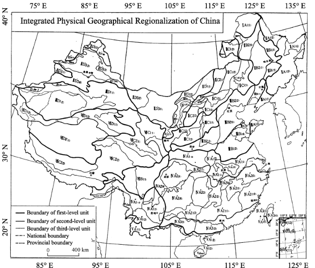
Figure 1 Map of Integrated Physical Geographical Regionalization of China (First Draft) (Huang, 1959)
Since then, the national scale researches of physical geographical regionalization have been widely conducted. For example, Ren (1961) proposed a few new opinions such as demarcating index, quantitative evaluation, hierarchical units and nomenclature. Hou (1963) proposed a regional division that aimed at developing agriculture, forestry and animal husbandry. The scheme was practical, with obvious target, but it still had some controversies such as the division of thermal zones. Zhao (1983) designed a relatively new scheme, which combined the lowest regional hierarchy unit with land types, and linked up with each other. In order to guide local plan and agricultural production, Xi et al. (1984) divided regions and described the details of regional physical features, agricultural situations, potential productivities and development directions. Hou (1988) divided China into 20 physical ecological regions including the guidelines for macro agricultural development in each region. In addition, Ren (1982) compiled physical geographical regionalization scheme for China in the 1980s, and illuminated the ways of resource utilization and environmental renovation for each region. Generally, although with different objectives, the researches of this stage have concretized regionalization theories, deepened the understanding of differentiation rules, and furthermore provided essential guidelines for local development and especially agricultural production in China.

2.3 Eco-geographical regions

Along with urgent demands of ecological construction and environmental protection, ecological ideas, principles and methods had been gradually introduced into the TS research (Bailey, 1983, 1996). In China, the eco-geographical regionalization research began since the end of the 1980s (Hou, 1988; Zheng et al., 1999, 2008; Fu et al., 2001).
In this stage, sensitivity, pressure and vulnerability of ecosystem and environment were given priorities in the ecological regionalization, and therefore sensitive or vulnerable regions were divided (Fu et al., 2001; Fu et al., 2015). In 2008, the eco-geographical regionalization system was published (Zheng et al., 2008) (Figure 2). The system emphasized the feature and differentiation of land degradation and rehabilitation, as well as ecological protection and construction planning in each eco-geographical zone. Furthermore, it also illuminated the difference, connection and utilization of physical conditions among all regions. Generally, the eco-geographical regionalization system has afforded a macro regional framework for the basic research of physical processes on land surface, and the harmonization of environment, resources and economic development as well. Moreover, it has also provided essential scientific basis for the improvement of potential land productivity, the analysis of land management policy, the introduction and popularization of advanced agricultural technology, the setup and planning of natural reserves, and environmental planning.
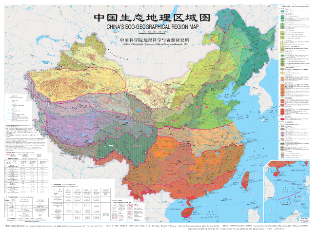
Figure 2 Map of Eco-geographical Regionalization of China (Zheng et al., 2008)

2.4 Comprehensive regionalization

With the research progress in earth system science and sustainable development, Professor Huang Bingwei proposed to carry out the comprehensive regionalization research in the end of the 20th-century (Huang, 2003). In his view, there should be a national comprehensive regionalization that takes both the nature and socio-economy into account appropriately, to satisfy the needs of new situation. As indicated by Liu et al. (2004), there had significant changes in China in the past 50 years, mainly include land surface pattern, resources and environmental pattern, and socio-economic development pattern. Meanwhile, the global environmental change and the economic globalization had brought new opportunities and challenges to the sustainable development and national security in China. However, the existing regionalization schemes could not completely fit to the new demands of situation. Therefore, the comprehensive regionalization research became essential, which should consider both natural and human factors synthetically and covers both land and sea systems (Liu et al., 2004). A few studies have been successively conducted to explore comprehensive demarcation of regions (Wu, 1998; Zheng et al., 1999; Ge et al., 2003; Wu et al., 2005).
However, the comprehensive regionalization research had difficulties to achieve breakthrough mainly because of absence of explicit direction and index system to demarcate. The major function-oriented zoning has solved the problem by taking the regional functions as the regionalization direction. According to the genetic principle, the major function-oriented zones have constructed the index system, and conducted the suitability evaluation works. Four major function zones of county scale, namely optimized, prioritized, restricted, and prohibited zones, have been proposed (Fan, 2015). These are the positive explorations on the national and regional comprehensive regionalization works, which aim at solving the problems of urban construction, economic development, resource utilization and ecological environment in China. The works had provided a new method for the comprehensive research of the physical and human factors.

2.5 Regional dynamic research

During the last century, the human activities (e.g. anthropogenic climate) have caused substantial impacts on natural system (IPCC, 2007; IPCC, 2013), which could be manifested in a short period. Therefore, the key factors of land surface have changed, and furthermore driven TS to change, which have been paid close attention.
Studies on the changes in TS have progressed gradually during the last decade in the 20th century, mostly based on the dominant criteria of TS and in situ observations. For example, the temperature zones in eastern China shifted northward under climate change in the last decades, with significant changes in the north subtropical zone and the warm temperate zone, through analyzing the variations of the accumulated temperatures and days above 10℃ and the average temperature of the coldest and the warmest month (Sha et al., 2002; Zhao et al., 2002; Ye et al., 2003). Compared with the temperature zone, the humidity zone boundaries varied in a fluctuating way (Yang et al., 2002). During the last 50 years, there was an obvious eastward shift of the boundaries of arid and semi-arid zones in the central part of Northeast China and northern part of North China, and a southward shift of the semi-arid boundary in the south of Shaanxi province and North China (Ma et al., 2005).
In addition, the studies on the response of TS to future climate change had gotten more and more attentions in China too. In the early 1990s, the temperature zone was estimated roughly based on an increment scenario of global temperature (Huang, 1993; Zhao, 1995; Zhao et al., 2002). For example, based on a hypothetical estimation of 3℃ warming in 2100, the majority part of cold temperate zone would shift to mid-temperate zone, and the majority part of mid-temperate zone mainly to warm temperate zone (Huang, 1993). Recently, the regionalization dynamic researches have carried out based on climate models and emission scenarios. For example, according to the regional climate models, Wu et al. (2010) projected the future changes of temperature zones, and found a generally northward-shift in the future. In their study, the subtropical zone, warm temperate zone and the northern boundary of plateau temperature zone would shift significantly with 6.6°, 5.3° and 3.1°N in the next 100 years, respectively.

3 Methods progress in China

With the rapid development of science and technology, and the increased application of TS in the 20th century, the TS studies have been promoted deeply in China. Methods have developed from qualitative to quantitative by integrating inductive and deductive methods, and combining top-down and bottom-up ways as well. Thus, the objectivity and repeatability of regionalization schemes have been enhanced.

3.1 Qualitative methods

During the stage of physical geographical regionalization in the 1950s, the delimitation methods were mainly qualitative. Generally, the representative qualitative method is expert integration, which is an empirical judgment of scholars on where is the boundary to delimit regions. However, the qualitative methods are usually subjective. For example, the research of integrated physical geographical regionalization in the 1950s aimed at providing scientific basis for the development of agriculture, forestry, husbandry and fishery. Therefore, the main classification principles included: classifying types before regions, emphasizing the contemporary physical geographical characteristics and the mutual relations, and combining zonality and azonality. For zonal classification, the first element to be considered was temperature which could not be altered by human activities easily, and the second was moisture condition which could be changed limitedly. Furthermore, boundaries were determined based on the regional differences of land surface elements including climate, vegetation, landform and soil, and then the quantitative indices to delimit boundaries were sought based on the geographical correlations with the elements (Huang, 1959).
Qualitative methods have the advantages of quickness and accuracy to determine the macro regional patterns. However, at small scale, the expert judgment would be strongly influenced by complex situations. Therefore, significant divergences on the specific problems such as the boundary direction occurred since the reality realization and knowledge backgrounds are different among scholars. For example, how to delimit the north boundary of tropical had introduced abundant discussion among scholars (Zeng et al., 1980; Huang, 1992; Qiu, 1993; Wu et al., 2000).

3.2 Quantitative methods

Since the 1980s, the quantitative methods have gradually applied in the TS research to enhance its objectivity and replicability. The key classification indices mainly reflect climate, landform, soil, vegetation, and other physical elements (Huang, 1989). Besides the key indices, indices reflect population, resources, environment, social and economic development level, and ecological management degree, are also involved in the comprehensive regionalization research (Ge et al., 2003). The identification index system of major function-oriented zoning of China comprises nine quantitative indicators (including water resources, land resources, ecological importance, ecological fragility, environmental capacity, disaster risk, economic development level, population concentration and transport superiority) and one qualitative indicator of strategic choice (Fan, 2015).
Along with the development of the observing and experimental technologies, remote sensing (RS), global positioning system (GPS) and geographic information system (GIS) technologies (hereafter 3S), the TS studies have progressed significantly, mainly in reflecting regional characteristics and indicating regional boundaries.
Indicators of the eco-geographical regionalization mainly include temperature criteria (e.g. days of temperature ≥10℃, accumulated temperature ≥10℃, mean temperature of January and July), humidity criteria (e.g. annual aridity index), vegetation and eco-geomorphologic type (Zheng et al., 2008). For example, 220 days of temperature ≥10℃ and 4500℃ of accumulated temperature ≥10℃ are two main criteria to delineate temperate zone and subtropical zone. Humidity criteria have been developed from Selianinov heat index, Thornthwaite wetness index to Penman-based aridity index, which are based on more meteorological variables such as radiation, temperature, wind speed, relative humidity and precipitation. Regions with annual aridity index less than 1.0 is usually demarcated as humid zone, 1.0-1.49 as sub-humid zone, 1.5-4.0 as semi-arid zone, and larger than 4.0 as arid zone (Zheng et al., 2008).
Since the 21st century, as the 3S technologies developed and improved, the synthesis and integration of geographical science have got a quantitative scientific basis and an advanced technology assurance (Chen, 2001). At the same time, models and mathematical simulation technologies were gradually applied in the TS research, such as artificial neural network (Li et al., 2003) and wavelet transform method (Li et al., 2008). At present, the TS research has put more emphasis on system ensemble, which focuses on integrating analysis and synthesis, and combining top-down deduction and bottom-up induction methods (Cai, 2010).

4 Prospects of the TS studies

Under the framework of global change and the Future Earth, the TS studies should be combined with the concepts, goals and contents of the Future Earth. In order to promote the TS research to a higher level, future highlights include: the interaction mechanism and regional effects of key land surface elements, the dynamic response to global change, the quantitative identification of the boundaries of regional units, and the enhancement of applicability of regionalization system.

4.1 Interaction mechanism and regional effects of key land surface elements

The land surface elements, which usually change in a dynamic balance, are driving changes in the physical geographical environment and forming the regional differences of the landscape. At present, the research on the trend and process of key single elements (including water, soil, air, living, etc.) has been relatively mature. However, the comprehensive research of multiple elements is not enough, and the system perspective of research is not clear. Moreover, the interaction of changes of multiple elements should be studied, especially the mechanism of dynamics of land surface pattern influenced by the inter-coupling of key elements. Therefore, future research should focus on the spatial-temporal changes of key elements during the last decades. Especially, we should clarify the impact and mechanism of spatial-temporal change and interactions of key elements on the land surface features, such as moisture conditions, heat resources, and land cover. Synergies and differences of key elements are also crucial.
The investigation of interaction mechanism between physical and human elements would provide basis for depicting regional characteristics comprehensively and objectively. In which, the fundamental scientific issues mainly include the coordination of physical and human elements in different regionalization level, and the selection of reasonable index. More researches should be conducted on how the ecosystem and human activities mutually restrict and promote each other. It mainly includes both the impact of human activities on the structure and function of ecosystem, and the feedback of ecosystem responses to human activities.

4.2 Dynamic response of TS to global change

Under the global change, the impact of human activities and climate change on land surface process has been more and more significant. At the same time, the vulnerability of physical and human elements and natural-social-economic compound system has varied. Therefore, the land surface pattern has changed accordingly. However, descriptions of land surface pattern were mainly static in order to reflect the average condition of long period. Dynamic response of TS to global change has been seldom conducted deeply. In the future, we should focus on the changing processes and patterns of key land surface elements, the tendency and amplitude of land surface pattern, and the dynamic response of land surface pattern to global change. It helps to reveal the driving mechanism of variations of land surface system, and conduct further research on the evolution of TS.
Usually in the past, long-term time series were thought to be better to represent the “normal” conditions of land surface pattern and could avoid “accident” conditions. However, along with the thorough research of global change, geographer found that changes in land surface elements could possibly lead to dynamic regional pattern under a long period, particularly the last hundred years featured with significant human activities. Such dynamics may have substantial impacts on the resource environment pattern and socio-economic layout. Therefore, it is urgent to study the varied interaction among key land surface elements, and its mechanisms, amplitude and spatial extent. Moreover, the role of the synergies and differences among changes in land surface elements in the regional formation and development of the needs to be revealed comprehensively and quantitatively. Last but not least, the dynamic responses of regionalization system to global change need to be clarified in different time scales from past to future under various socio-economic development scenarios. Recently, this work has received the support from the key project of National Natural Science Foundation of China.

4.3 Quantitative identification of the boundaries of regional units

Quantitative methods are advanced for land surface elements. However, these methods could not be fully applied to land surface pattern since TS represents the interaction among different elements. Moreover, the interactions among elements are nonlinear, making their spatial patterns not completely consistent. Therefore, the regional boundary is not simply the summation of several elemental boundaries. As a result, the recognition of regional boundary was usually under debate. Demarcation of land surface pattern needs information technology on the premise of theory unity. Synthesizing the expert intelligence, concept analysis, information technology, model application, multidisciplinary integration and other methods, to realize the quantitative recognition of regional unit boundaries, would be a breakthrough of regionalization system research.

4.4 Enhancement of applicability of regionalization system

The aims of regionalization system research are to understand natural rules, and to serve practices such as production and ecological construction. The achievements have provided decision-making advice and scientific basis for government and society, and generated great economic and social benefits. The existing researches have played a unique and important role in the national and regional constructions, especially in agricultural production, land investigation and planning, resources investigation and development, productivity layout, environment renovation, regional and urban planning, and nature reserve construction. In addition, the regionalization researches have greatly enhanced their application values and scientific level, and also promoted the development of other disciplines.
Nowadays, along with the orientation of ecological civilization construction, the TS research should pay more attention to resources, ecosystems and environment. Furthermore, researches on the impact and feedback of human activities on environment need to be strengthened, in order to enhance the objectivity and applicability of regionalization systems. It would be benefit for guiding ecological construction and socio-economic sustainability.

The authors have declared that no competing interests exist.

1
Bailey R G, 1983. Delineation of ecosystem region.Environmental Management, 7: 365-373.

2
Bailey R G, 1996. Ecosystem Geography. New York: Springer-Verlag.

3
Cai Y L, 2010. New perspectives on physical geography.Geographical Research, 29(1): 1-10. (in Chinese)

4
Chen S P, 2001. Information and modernization of geography.Scientia Geographica Sinica, 21(3): 193-197. (in Chinese)In the 20th century, the achievement of geo science was resplendent in China, which established the modern scientific basis. Confronted with chance and challenge to globalization, network and knowledge economy in 21st century, global study need to be emphasized. The earth's surface between ionosphere and Moho surface is the mean layer of information transmission and the most active human civilization, all of these belong to comprehensive research fields of geo system science. Progress in the earth observation technology system and advancement of temporal and spatial resolution have made global synchronous dynamic monitoring into reality, information source is very profuse. Networkation has strategically exploited some new research areas, such as "Geo information science" and "Digital Earth"; which has enhanced our reunderstanding to urbanization, resource, ecology and environment; and strengthened the ability of geographical strategy decision and participating in project programming and planning. Geography is comprehensive subject derived from nature and based on human, which always pays attention to exploiting temporal law and spatial structure and its transformation, geographical science must deeply mine profound geo information resources, accelerate its informalization and modernization, thus it can fully bring whole and traditional predominance into play. With globalization, network and intelligence together, geo science must have splendent future in the 21st century

5
Fan J, 2015. Draft of major function oriented zoning of China. Acta Geographica Sinica, 70(2): 186-201. (in Chinese)lt;p>Major Function Oriented Zoning (MFOZ) is the blueprint for the future developmnt and protection pattern of China's territory, and has been raised to from major function zones planning to major function zoning strategy and major function zoning institution. From 2004 to 2014, the author organized a series of research projects to compose MFOZ for the country, studied basic theory of regional function and MFOZ technical process, and proposed that space controlling zones of national and provincial scales can be divided into four types: urbanized zones, foodstuff-security zones, ecological safety zones, cultural and natural heritage zones. On this basis, major function zones of county scale should be transferred to optimized, prioritized, restricted, and prohibited zones. In this paper, a regional function identification index system comprising nine quantitative indicators (including water resources, land resources, ecological importance, ecological fragility, environment capacity, disaster risk, economic development level, population concentration and transport superiority) and one qualitative indicator of strategic choice is developed. Based on the single index evaluation, comprehensive evaluation using regional function suitability evaluation index is conducted, aiming at testing several key parameters including lower limit of protection zones and upper limit of development zones at the provincial level. In addition, a planning-oriented zoning method of major function zones is also discussed, which has brought the first MFOZ planning in China. According to the MFOZ caliber, it is forecasted that national spatial development intensity will rise from 3.48% in 2010 to 3.91% in 2020. Furthermore, according to caliber of the provincial integrated MFOZ planning, the area of optimized, prioritized and restricted zones accounts for 1.48%, 13.60% and 84.92%, respectively, and that of urbanized, foodstuff-security and ecological safety zones accounts for 15.08%, 26.11% and 58.81%, respectively. In combination of analyses of development level, resources and environmental carrying status and quality of the people's livelihood, the main characteristics of MFOZ were identified. Through verification, MFOZ draft of national and provincial scales, which is interactively accomplished with "MFOZ Technical Process" put forward by the author, is mostly above 80% identical with what have been forecasted.</p>

DOI

6
Fu B J, Liu G H, Chen L Det al., 2001. Scheme of ecological regionalization in China.Acta Ecologica Sinica, 21(1): 1-6. (in Chinese)Ecological regionalization is a base for rational management and sustainable utilization of ecosystems and natural resources It can provide scientific basis for constructing healthy ecological environments and making policies of environmental management In this paper, based on synthetical analysis of the characteristics of ecological environments of China, the principles of ecological regionalization are discussed, and indices and nomenclature of ecological regionalization are proposed, The ecoregions in national scale are divided The results show that there are 3 domains, 13 ecoregions and 57 ecodistricts

7
Fu B J, Liu G H, Ouyang Z Y, 2015. Ecological Regionalization in China. Beijing: Science Press. (in Chinese)

8
Future Earth, .

9
Ge Q X, Zhao M C, Zheng J Yet al., 2003. Division of the terrestrial system in China: A case study from Huang’s theory on terrestrial system science.Scientia Geographica Sinica, 23(1): 1-6. (in Chinese)

10
Holdridge L R, 1967. Life Zone Ecology. San Jose: Tropical Science Center.

11
Hou X Y, 1988. Physical Ecological Regionalization and Macro-agricultural Developing Strategy in China. Beijing: The Commercial Press. (in Chinese)

12
Hou X Y, Jiang S, Chen C D, 1963. Suggestion on the developing direction of agriculture, forestry, animal husbandry, sideline production and fishery in different regions of China.Chinese Science Bulletin, (9): 8-26. (in Chinese)

13
Huang B W, 1959. Draft of the Integrated Physical Geographical Regionalization of China.Chinese Science Bulletin, 18: 594-602. (in Chinese)

14
Huang B W, 1989. Outline of the Comprehensive physical geographical regionalization of China. Collected Works of Geography, 21: 10-20. (in Chinese)

15
Huang B W, 1992. Comment on the northern border of tropical zone in China: I. The international definition of tropical zone and sub-tropical zone.Scientia Geographica Sinica, 12(2): 97-104. (in Chinese)

16
Huang B W, 1993. How to deal with global warming. In: Editorial Committee of Huang Bingwei Collection (ed.). Collections of Huang Bingwei’s Sixty Years Comprehensive Work of Physical Geography. Beijing: The Commercial Press, 470-484. (in Chinese)

17
Huang B W, 2003. Problems on regionalization in the new period. In: Editorial Committee of Huang Bingwei Collection (ed.). Collections of Huang Bingwei’s Integrated Research in Physical Geography. Beijing: The Commercial Press, 350-352. (in Chinese)

18
Koeppen W, 1931. Grundriss der Klimakunde. Berlin: Walter de Gruyter.

19
Li S C, Zhao Z Q, Gao J B, 2008. Identifying eco-geographical boundary using spatial wavelet transform.Acta Ecologica Sinica, 28(9): 4313-4322. (in Chinese)This paper attempts to use spatial wavelet transformation derived multi-scale module maximum as a geographical locator to objectively identify eco-geographical transition zone and its boundary.Employing the spatial patterns of NDVI and precipitation,we decomposed 49 transects with wavelet transformation of db3 kernel function.The geographical coordinates of all singularity points were located and marked in GIS.The results show that optimal spatial scale for identifying eco-geographical boundary of semiarid-subhumid transition zone is about 20-40 km.When the scale is less than this threshold value,the locating process is likely influenced by local scale ground structure such as built-up areas or fine scale landforms.On contrary,when the scale is larger than 20-40 km,the accuracy of locating points will drop sharply owing to over-smoothing treatment.In spite of the higher concentration degree of NDVI derived locating points than that of precipitation derived,the comprehensive locating accuracy for precipitation transition zone is superior to that of NDVI spatial pattern in terms of long axis direction coherence,mean minimum distance and point balance degree indicates.Our results suggest that the combination of spatial wavelet transformation and GIS is a powerful complement approach to expert based eco-geographical transition zone identification and locating.

20
Li S C, Zheng D, 2003. Applications of artificial neural networks to geosciences: Review and prospect.Advance in Earth Science, 18(1): 68-76. (in Chinese)Neural networks are increasingly popular in geosciences due to big progress in neural network modelling techniques and imperative demands in geosciences. Without assuming parametric relationship, artificial neural networks have the ability to learn patterns of relationships in data from being shown a given set of inputs including combinations of descriptive and quantitative data, generalize or abstract results from imperfect data, and be insensitive to minor variations in input such as noise in the data, missing data, or a few incorrect values. When the neural network is trained appropriately, it generalizes the relationship so that it can be applied to other new data sets. The theoretical basis of this technique is the universal approximation theorem, which states that a multi ayer feed orward neural network, such as the radial asis function or perceptron neural network, is capable of performing any nonlinear input utput mapping. In this paper, the applications of ANNs in various branches of geosciences have been examined here. It is found that ANNs are robust tools and alternative approaches for modeling many of the nonlinear processes in geosciences. After appropriate training, they are able to generate satisfactory results for solving many problems such as prediction, classification, pattern recognition and optimization. By counting the 349 ANNs ased papers in geosciences during the 1997-2000, three predominant subjects are hydrology, geology and atmospheric science, and prediction is major modelling purpose. After reviewing the state of the art of geoscience's ANN modelling, author thinks that integrated ANNs modelling framework must be developed in order to deal with more complex nonlinear processes. Such integrated framework consists of non arametric techniques such as neural network, fuzzy logic, genetic algorithm, simulated annealing algorithm, fractal theory, Cellular automata and wavelet transform tc. It is helpful for selecting appropriate input and output neurons and designing more efficient networks to profoundly understand the linear or nonlinear processes being modeled in geosciences. Important aspects such as physical interpretation of ANN architecture, optimal training data set, adaptive learning, and generalization must be explored further. The merits and limitations of ANN applications have been discussed, and potential research avenues have been explored briefly.

DOI

21
Lin C, 1954. Outline of the physical geographical regionalization. Acta Geographica Sinica, 20(4): 395-418. (in Chinese)

22
Liu Y H, Ge Q S, Zhang X Q, 2004. Thoughts about the development for the research of human dimensions on global environmental change in China.Advances in Earth Science, 19(6): 889-895. (in Chinese)

23
Liu Y H, Zheng D, Ge Q Set al., 2005. Problems on the research of comprehensive regionalization in China.Geographical Research, 24(3): 321-329. (in Chinese)The modern regionalization in China has attained plentiful and substantial achievements in recent 50 years and has made important contributions to the socio-economic construction. Meanwhile, great changes have taken place in the natural and socio-economic patterns in China. So it is indispensiable to develop comprehensive regionalization as the basis of the sustainable socio-economic development for China. The main scientific issues to be discussed are as follows: 1) the target of service and the mission of research; 2) the theory and system of comprehensive regionalization; 3) the changing processes, patterns and their interactions of the main elements in regional system; 4) the identification of the boundaries between the regional systems in China; 5) the identification of typical regions and the analysis on their characteristics; 6) the interaction between the global geographical patterns and the comprehensive regional system in China; 7) data mining, processing and dimensioning; 8) the integrative methodology of comprehensive regionalization; 9) scenario analysis for the future evolution of regional system in China; and 10) the dynamic demonstration system for the comprehensive regionalization.

DOI

24
Luo K F, 1954. Draft of the physical geographical regionalization of China.Acta Geographica Sinica, 20(4): 379-394. (in Chinese)

25
Ma G Z, Fu C B, 2005. Decadal variations of arid and semi-arid boundary in China.Chinese Journal of Geophysics, 48(3): 519-525. (in Chinese)

26
Qin D H, 2014. Climate change science and sustainable development.Progress in Geography, 33(7): 874-883.Since the Fourth Assessment Report (AR4) was released by the Intergovernmental Panel on Climate Change (IPCC) in 2007, new observations have further proved that the warming of the global climate system is unequivocal. Each of the last three successive decades before 2012 has been successively warmer at global mean surface temperature than any preceding decade since 1850. 1983-2012 was likely the warmest 30-year period of the last 1400 years. From 1998 to 2012, the rate of warming of the global land surface slowed down, but it did not reflect the long-term trends in climate change. The ocean has warmed, and the upper 75 m of the ocean warmed by more than 0.11℃ per decade since 1970. Over the period of 1971 to 2010, 93% of the net energy increase in the Earth's climate system was stored in the oceans. The rate of global mean sea level rise has accelerated, which was up to 3.2 mm yr-1 between 1993 and 2010. Anthropogenic global ocean carbon stocks were likely to have increased and caused acidification of the ocean surface water. Since 1971, the glaciers and the Greenland and Antarctic ice sheets have been losing mass. Since 1979, the Arctic sea ice extent deceased at 3.5% to 4.1% per decade, and the Antarctic sea ice extent in the same period increased by 1.2% to 1.8% per decade. The extent of the Northern Hemisphere snow cover has decreased. Since the early 1980s, the permafrost temperatures have increased in most regions. Human influence has been detected in the warming of the atmosphere and the ocean, changes in the water cycle, reductions in snow and ice, global mean sea level rise, and changes in climate extremes. The largest contribution to the increase in the anthropogenic radiative forcing was by the increase in the atmospheric concentration of CO<sub>2</sub> since 1750. It led to more than half of global warming since the 1950s (with 95 % confidence). It is predicted using Coupled Model Intercomparison Project Phase 5 (CMIP5) and Representative Concentration Pathways (RCPs) that the global mean surface temperature will continue to rise for the end of this century, the frequency of extreme events such as heat waves and heavy precipitation will increase, and precipitation will present a trend of "the dry becomes drier, the wet becomes wetter". The temperature of the upper ocean will increase by 0.6 to 2.0℃ compared to the period of 1986 to 2005, heat will penetrate from the surface to the deep ocean which will affect ocean circulation, and sea level will rise by 0.26 to 0.82 m in 2100. Cryosphere will continue to warm. To control global warming, humans need to reduce the greenhouse gas emissions. If the increase in temperature is higher than 2℃ than before industrialization, the mean annual economic losses worldwide will reach 0.2% to 2.0% of income, and cause large-scale irreversible effects, including death, disease, food insecurity, inland flooding and water logging, and rural drinking water and irrigation difficulties that affect human security. If taking prompt actions, however, it is still possible to limit the increase in temperature within 2℃. To curb the gradually out-of-control global warming and achieve the goal of sustainable development of the human society, global efforts to reduce emissions are needed.

DOI

27
Qiu B J, 1986. A scheme of national agricultural integrated regionalization in China. Journal of Henan University (Natural Science), 16(1): 21-28. (in Chinese)

28
Qiu B J, 1993. The northern border of tropical zone in China.Scientia Geographica Sinica, 13(4): 297-306. (in Chinese)This paper makes comment on the article“The extent of tropical zone in China”in Vol.11,No.2 of this journal. The tropics,subtropics and temperate zone are divided by temperature indices.Temperature is only one of the climatic elements.Climatic zones are also divided by the other climatic elements.Their extents and borders are very different to each other.Many climatologists do not agree the temperature zones.It is difficult that all of biogeographers,pedogeographers and physical geographers agree to temperature zones. When subdividing physical geographical zone,it should be comprehensively considered to all factors of physical geography,especially the factor of climate.It is not enough to consider the factors of vegetation and soil. The author considers that thermophilous crop,such as rice can be cultivated in whole year,and tropical woody plants,such as rubber tree do not suffer from freeze in tropical zone.The northern boundary of tropical zone coincides with 15℃ isotherm of the coldest month,and 5℃ isotherm of the mean annual minimum.Because the winter monsoon is very strong and very cold in China,so the Chinese tropics situates in the edge of world tropics,its boundary line should not lie too north,but in north of Leizhou Peninsula.

29
Ren M E, 1982. Outline of Chinese Physical Geography. Rev. ed. Beijing: The Commercial Press, 1-412. (in Chinese)

30
Ren M E, Yang R Z, 1961. Physical geographical regionalization in China.Acta Geographica Sinica, 27: 66-74. (in Chinese)

31
Sha W Y, Shao X M, Huang M, 2002. Climate warming and its impact on natural regional boundaries in China in the 1980s.Science in China: Series D, 32(4): 317-326. (in Chinese)正 The global climate warming accelerated in the 1980s has become a focus in the world. Based on the month by month and year by year temperature data from 160 representative stations throughout the country during 1951-1999, this paper analyses annual and four seasons' temperature variations of China

DOI

32
Wu S H, 1998. The Basic Designation of integrated zonation: Case study of Chaidam basin.Geographical Research, 17(4): 367-374. (in Chinese)Development of science, technology and social economic requires a basic research correspondent with regional social economic development to comprehensively identify regional characteristics. Integrated zonation, which is further researches on natural zonation, combines natural environment with social economic and serves regional economic development. Integrated zonation meets the requirements of regional economic development. In this paper, based on summary of natural zonation, ideology of resources is introduced for regional division. Specifically, “resources groups” and “resources types” which are closely related to social economic development are used to form the fourth level and fifth level classes, the insufficient researched zonation classes before. This paper takes Chaidam Basin case as an example to establish a regional integrated zonation system for the sustainable regional economic development.

DOI

33
Wu S H, Liu W D, 2005. An integrated approach to classification of territorial systems: A case study of Tibetan Plateau.Geographical Research, 24(2): 169-177. (in Chinese)Recent geo-researches display two significant features. First, most research projects are centered on revealing the implications for regional sustainable development and ecological security; and second, these projects try to employ an integrated approach to taking both physical and socio-economic factors into consideration. Indeed, the implementation of sustainable development strategy demands a classification of territorial systems based on such an integrated approach. To be integrated, a key scientific issue is how to synthesize the physical and socio-economic factors in the process of classification. Based on a new indicator system, which involves mainly physical indicators at the macro level and socio-economic indicators at micro level while employing both at the middle level, this paper tries to develop a new integrated approach to the classification of territorial systems to reveal the features of human-nature relationship at various spatial levels. The new system of classification is a hierarchy consisting of five levels: class zero realm; class one ecological zone (and/or) sub-zone; class two land-human region; class three eco-economic division; and class four economic districts. The classification at the first three levels is a "top-down" process; that at the fifth level is a "bottom-up" process; and that at the fourth level is a matching process from both the top and the bottom. The paper further tests the new approach of classification via a case study of the Tibetan Plateau. By the approach, the Plateau is divided into 3 zones, 15 regions, 22 divisions and 29 districts. Such classification results have profound implications for regional sustainable development.

DOI

34
Wu S H, Zheng D, 2000. New recognition on boundary between tropical and subtropical zone in the middle section of eco-geographic System.Acta Geographica Sinica, 55(6): 689-697. (in Chinese)This paper discusses division on tropical and subtropical boundary in middle portion of South China. This discussion results in new understanding on eco geographic regions and their boundaries, especially on gradual changes of natural conditions between eco geographic regions. It also analyzes results of the same area by other researchers, clarifies differences and causes of the differences of the results. Boundaries of eco geographic region cannot be drawn as a line as changes from tropical to subtropical zone are gradual. Therefore, for an eco geographic region like tropical zone, definite boundaries must be drawn while considering gradual changes. Temperature, vegetation and soil are relevant indexes to divide tropical and subtropical zones. After indexes of the tropical zone are confirmed, data of annual average index reflect general state of the tropical zone. Line from such data is called ropical boundary. On the other hand, affected by the monsoon climate, some years are hotter and some are cooler. In hotter year, temperature of north area of tropical boundary reaches tropical state while in cooler year, such area moves southward. Boundary of the hottest year is called annual tropical line and that of the coolest year is called real tropical line. Temperatures in areas of south to annual tropical line can probably reach that of tropical zone in some years. Temperatures in areas of south to real tropical line can reach that of tropical every year. Area from true tropical to annual tropical is called tropical fluctuating zone. Therefore, new concepts of tropical, annual tropical, true tropical and tropical fluctuating zone are formed to understand tropical area in a new point of view in the paper. Based on the index of climate, vegetation and soil, boundaries of tropical, annual tropical, true tropical and tropical fluctuating zone of the study area are established. The tropical fluctuating zone explains different locating of different researchers. The paper also puts forward a new method to displaies boundary for eco geographic regions.

35
Wu S H, Zheng D, Yin Y Het al., 2010. Northward-shift of temperature zones in China’s eco-geographical study under future climate scenario.Journal of Geographical Sciences, 20(5): 643-651.<p>Despite the well-documented effects of global climate change on terrestrial species&rsquo; ranges, eco-geographical regions as the regional scale of ecosystems have been poorly studied especially in China with diverse climate and ecosystems. Here we analyse the shift of temperature zones in eco-geographical study over China using projected future climate scenario. Projected climate data with high resolution during 1961&ndash;2080 were simulated using regional climate model of PRECIS. The number of days with mean daily temperature above 10℃ and the mean temperature of January are usually regarded as the principal criteria to indicate temperature zones, which are sensitive to climate change. Shifts due to future climate change were calculated by comparing the latitude of grid cells for the future borderline of one temperature zone with that for baseline period (1961&ndash;1990). Results indicated that the ranges of Tropical, Subtropical, Warm Temperate and Plateau Temperate Zones would be enlarged and the ranges of Cold Temperate, Temperate and Plateau Sub-cold Zones would be reduced. Cold Temperate Zone would probably disappear at late this century. North borderlines of temperature zones would shift northward under projected future climate change, especially in East China. Farthest shifts of the north boundaries of Plateau Temperate, Subtropical and Warm Temperate Zones would be 3.1&deg; 5.3&deg; and 6.6&deg; latitude respectively. Moreover, northward shift would be more notably in northern China as future temperature increased.</p>

36
Xi C F, Zhang J M, Qiu B J et al., 1984. Outline of Physical Regionalization of China. Beijing: Science Press. (in Chinese)

37
Yang J P, Ding Y J, Chen R Set al., 2002. The interdecadal fluctuation of dry and wet climate boundaries in China in recent 50 years.Acta Geographica Sinica, 57(6): 655-661. (in Chinese)<p>Based on the annual mean precipitation and evaporation data of 295 stations covering 1951-1999, the aridity index is calculated in this paper. The climatic regions in China are classified into three types, namely, arid region, semi-arid region and humid region. The number 0.20 (D) is the boundary between arid and semi-arid regions and 0.50 (D) is the boundary between semi-arid and humid climate regions. Dry and wet climate in China fluctuates markedly and differentiates greatly in each region in recent 50 years. The fluctuation amplitude is 20-400 km in Northeast China, 40-400 km in North China, 30-350 km in the eastern part of Northwest China and 40-370 km in Southwest China in recent 40 years. Before the 1980s (including 1980), climatic trend was dry in Northeast and North China, wet in the eastern part of the Northwest and very wet in the Southwest. In the 1990s dry signs appeared in the Southwest, the eastern part of Northwest China and North China. During the 1960s and 1970s dry and wet climates in China had single mutation changing wetness into drought. Moreover, drought shows an increasing trend. Dryly and wetly climatic boundary shows the fluctuation characteristics of the whole movement and the different fluctuations in East, West, South and North directions. The fluctuation of climatic boundary and the dry and wet variations of climate have 10 distinctive inter-annual features. It was drier in the 1950s, 1970s and 1990s in Southwest China, the eastern part of Northwest China (except Hexi region) and the first region in North China. It was wetter in the 1960s and 1980s.</p>

38
Yang W H, Yang Q Y, 2014. History of Geography in China (Ancient Volume). Nanning: Guangxi Education Press. (in Chinese)

39
Ye D Z, Jiang Y, Dong W J, 2003. The northward shift of climatic belts in China during the last 50 years and the corresponding seasonal responses.Advances in Atmospheric Sciences, 20(6): 959-967.Along the meridian of 105°E, the Chinese region are divided into two parts, east and west. The results show that in the east part of China the temperate extratropical belt, the warm extratropical belt, and the northern subtropical belt shift northward significantly, whereas the middle subtropical belt and the southern subtropical belt have less or no change. As for the northern subtropical belt, the maximal northward shift can reach 3.7 degrees of latitude. As for the warm extratropical belt, along the meridian of 120°-125°E, the maximal northward shift can reach 3-4 degrees. In the west part of China, each climatic belt changes little. Only in the Xinjiang area are the significant northward shifts. Correspondingly, it is found that in the last 50 years the traditional seasons have changed. For Beijing, Hailar, and Lanzhou, in general, summer becomes longer and winter shorter over the last 50 years. Summer begins early and ends late with respect to early 1950s. Contrary to the summer, winter begins late and ends early with respect to early 1950s. Furthermore, spring and autumn have changed over the last 50 years: with respect to early 1950s spring begins early and autumn begins late.

DOI

40
Zeng Z X, Liu N W, Li G Zet al., 1980. Discussion on tropical border of China.Acta Geographica Sinica, 35(1): 87-91. (in Chinese)

41
Zhao M C, 1995. Impact of CO2 multiplication on the differentiation of physical zones and the potential agricultural productivity in China.Journal of Natural Resources, 10(2): 148-157. (in Chinese)The study of CO<sub>2</sub> multiplication which leads to the warming of global climate and influences the natural environment has become a main subject of the world's attention. IPCC has made a forecast. On the basis of it this paper analyses the impact of climatic change on the differentiation of the physical zones in China. Using the data of 671 meteorological stations the author has analysed the numerical indexes of temperature zones and natural regions of China, the potential agricultural productivity of various regions and the facors which influence the potential agricultural productivity and drawn up the maps which show the northward move of the temperature zones, the westward move of the precipitation regions and the change of the boundary between the dry and wet regions after the warming of the climate.All of these works are completed by using the mathematical modeling and computers. The results indicate that in China the warming of the globla climate will increase the area of warm region,improve the water conditions in the arid and semi-arid regions and increase the productivity of the land.

DOI

42
Zhao S Q, 1983. A new scheme for comprehensive physical regionalization in China.Acta Geographica Sinica, 38(1): 1-10. (in Chinese)

43
Zhao X Y, Zhang H Y, Wan J, 2002. The impact of climatic change on the climate zones in the Qinghai-Tibetan Plateau. Scientia Geographica Sinica, 22(2): 190-195. (in Chinese)

DOI

44
Zheng D, Fu X F, 1999. A preliminary study on issues of integrated geographical regionalizationScientia Geographica Sinica, 19(3): 193-197. (in Chinese)Regional study is an ancient and important tradition, forming the regional school of geography. In view of integrated or unified geography, regional study of sustainable development is an important level for approaching regional system of man-land relationship and effective way for coordinating man-nature relationship. Aimed at sustainable development the integrated geographical regionalization includes natural elements and human factors. Main principles for demarcation are as follows: combining regional differentiation of physical environments and human geography, integrating comprehensive analysis and principal factors, genetic unity, as well as linking regional frameworks with regional types, etc. Criterion and index system of the integrated geographical regionalization consists of environments, resources, economy, society and population, etc. The selected criteria and indices for demarcation should be practical, simplified, comparable, quantified, and reflecting dynamic state and trends of various regions. Regional types of development states may be identified based on the above mentioned results, then proposing a tentative scheme of the integrated geographical regionalization.

45
Zheng D, Yang Q Y,Wu S H et al., 2008. China’s Ecogeographical Regionalization Research. Beijing: The Commercial Press. (in Chinese)

46
Zheng D, Yang Q Y, 2015. Review and prospects: Geography in China since 1950s.Science, 67(4): 29-33. (in Chinese)

47
Zheng D, 1999. A Study on the Eco-geographic Regional System of China. Cambridge: FAO FRA2000 Global Ecological Zoning Workshop.

48
Zhou L S, She Z X, 1990. Agricultural geography and land utilization. In: Recent Development of Geographical Science in China. Beijing: Science Press, 29-40. (in Chinese)

49
Zhu K Z, 1930. Climatic provinces of China. Geographical Journal, 3(2). (in Chinese)

Outlines

/