Orginal Article

Integrated studies of physical geography in China: Review and prospects

  • FU Bojie , 1, 2 ,
  • PAN Naiqing 1, 2, 3
Expand
  • 1. State Key Laboratory of Urban and Regional Ecology, Research Center for Eco-Environmental Sciences, CAS, Beijing 100085, China
  • 2. Joint Centre for Global Change Studies, Beijing 100875, China
  • 3. University of Chinese Academy of Sciences, Beijing 100049, China

Author: Fu Bojie, Professor and CAS Academician, specialized in physical geography and landscape ecology. E-mail:

Received date: 2016-03-25

  Accepted date: 2016-04-02

  Online published: 2016-07-25

Supported by

National Natural Science Foundation of China, No.41230745

Copyright

Journal of Geographical Sciences, All Rights Reserved

Abstract

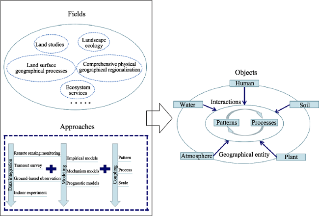
Modern physical geography in China grew from Chinese traditional geography and has been profoundly influenced by the geographical disciplines of Euro-America and Russia. Since the 1950s, integrated studies of physical geography in China have made remarkable progress in the fields of comprehensive physical geographical regionalization, land studies, landscape ecology, and land surface geographical processes. During the past few decades, under the background of global change and rapid socio-economic transformation, a series of environmental and resources problems have boomed in China. To solve these problems and promote the development of integrated studies of physical geography, the following issues were proposed as research priorities: (1) coupling of land surface patterns and processes; (2) integrated research on regional responses and adaptation to global change; (3) analysis of human dimensions of the earth system; (4) ecosystem service research from a geographical perspective; (5) integration of multi-source data and model development; (6) integrated studies on unique geographical units; and (7) important global issues and relevant international programs.

Cite this article

FU Bojie , PAN Naiqing . Integrated studies of physical geography in China: Review and prospects[J]. Journal of Geographical Sciences, 2016 , 26(7) : 771 -790 . DOI: 10.1007/s11442-016-1298-8

1 Introduction

Modern physical geographical research in China is deeply affected by the thoughts and theories of Euro-American and Russian geography and Chinese traditional geography. Geographical research has a long history in China, and the earliest geographical writings can be traced back to over two thousand years ago (Sun, 1990). Numerous ancient chorographies, monographs and maps recorded abundant geographical information, most of which was filled with empirical descriptions. Traditional thoughts such as the ‘unity between the heavens and man’ and ‘practical statecraft’ were also embodied in those literatures (Yu, 1993; Cai, 2010). In the late 19th century, people began to translate foreign geography literature into Chinese (Ai, 1995, 1996). The western tradition of splitting geography into physical and human geography profoundly affected the development of this discipline in China. Henceforth, the theories, methodologies and techniques of modern physical geography were gradually learned and accepted by domestic scholars. In the 1930s, domestic integrated studies of physical geography began with physical regionalization and integrated studies on the environmental evolution during the historical periods (Xu et al., 2009; Yue et al., 2010). Intensive Sino-Soviet academic communications in the 1950s made significant contributions to the development of China’s physical geography. The zonality theory and the perspective of landscape science promoted the establishment of integrated physical geography as a new specialty (Cai, 2010), which greatly facilitated the advancement of integrated studies of physical geography (Chen, 1993). The framework (Figure 1) shows the fields, objects and approaches of integrated studies of physical geography. The major fields of integrated studies of physical geography include comprehensive physical geographical regionalizations, land studies, landscape ecology and land surface geographical processes. In recent years, studying ecosystem services from geographical perspectives has received increasing attention, which extended the research scope of physical geography (Li et al., 2014). Multiple approaches have been adopted by scholars to understand the patterns and processes of the comprehensive geographical entities that were shaped by the interactions of various physical and human factors.
Figure 1 Framework of integrated studies of physical geography
Since the 1950s, Chinese scholars have made remarkable progress in integrated studies of physical geography. On the eve of the 33rd International Geographical Congress, there is a need to review the theoretical and methodological advances in these fields and look to their future. The purpose of this paper is twofold: (1) to give geographers both at home and abroad a general idea of the development process of these studies and (2) to explore future trends and research needs.

2 Main theoretical and methodological progress

2.1 Comprehensive physical geographical regionalization

The earliest geographical regionalization scheme in China was recorded in ancient literature - Yu Gong, which was written more than 2500 years ago (Zheng et al., 2005). However, it was only in the early 20th century that Chinese geographers began to carry out modern geographical regionalizations. Several domestic and foreign scholars such as Huang Bingwei, Li Xudan, Zhu Kezhen, G. B. Cressey and P. M. Roxby made certain explorations (Zhu, 1929; Lee, 1947; Zhao et al., 1979). Although the schemes of that period may seem preliminary by today’s standards, their contributions to the subsequent development of comprehensive physical geographical regionalization should not be neglected.
After the founding of the People’s Republic of China in 1949, the new born nation had an urgent need for comprehensive knowledge of its physical environment and natural resources, which promoted systematic integrated surveys of natural resources (Sun et al., 2010). These integrated surveys collected massive amounts of data about geographical entities, which laid a solid foundation for comprehensive physical regionalization research. Based on differences in climate, geomorphology, hydrology, vegetation, animal, and soil conditions, Luo (1954) proposed a three-level hierarchical regionalization scheme, which divided China into 2 parts, 7 basic regions, and 23 sub-regions. At almost the same time, another scheme arose (Lin et al., 1954). That scheme partitioned China’s territory into four parts according to landforms and geologic structures. The four parts were further divided into 10 divisions based on differences in climate, and those 10 divisions were in turn partitioned into 31 regions and 105 sub-regions according to disparities in landforms. The two schemes mentioned above set up a preliminary methodological framework for subsequent regionalization (Liu, 2004), although many of the concrete boundaries were different (Shi, 1954).
The establishment of the Natural Regionalization Work Commission in 1956 marked the beginning of systematic regionalization in China (Wu et al., 2003). After that, the objective of regionalization changed from creating knowledge to meeting the demands of agricultural development. Based on several thematic regionalization formulations, a seven-level hierarchical regionalization scheme was proposed, dividing China into 3 natural realms, 6 heat zones, 18 natural divisions/sub-divisions, 28 natural zones/sub-zones, and 90 natural provinces (Huang, 1959). The regionalization hierarchy of this scheme was composed of zonal and azonal regionalization units. In the first five levels, bioclimatic conditions dominated the regionalization, and in the last two levels, azonal factors such as landforms, lithologies, and groundwater were taken into consideration. Holding the viewpoint that each regionalization unit was a comprehensive geographical entity controlled by both zonality and azonality, Ren and Yang (1961) put forward a novel scheme that did not use a unified regionalization index system. Under the ‘top-down’ methodological framework constructed by the four aforementioned schemes, two additional nationwide regionalization schemes were developed (Hou et al., 1963; Xi et al., 1984). Considering the drawbacks of the ‘top-down’ framework in the classification of low-level regional units, Zhao (1983) proposed a ‘bottom-up’ approach that linked land use classification to regionalization.
Debates remain on several regionalization issues, including the understanding of the zonality theory, regionalization principles, the selection of index systems and the determination of several critical boundaries (Yang et al., 2002; Zheng et al., 2005). A representative debate, which lasted several decades, dealt with the concepts and boundaries of the subtropical zone (Zhu, 1958; Zeng et al., 1980; He et al., 1988; Ren et al., 1991; Huang, 1992; Qiu, 1993; Wu et al., 2000). The majority of the physical geographers agreed that the northern boundary of the subtropical zone is situated at approximately 34˚N; nevertheless, the locations of the southern boundary in different schemes differed significantly.
Since the 1990s, research on a comprehensive physical regionalization has entered a new stage, and more ecological and socio-economic considerations have been a trend in those studies. Promoted by the practical demands of environmental protection and ecological restoration, an increasing number of ecological theories and methods have been integrated into the regionalization process. Several influential schemes have been proposed (Hou, 1988; Yang et al., 1999; Zheng, 1999; Fu et al., 2001; 2004), which differ in terms of their objectives and concrete methods. However, ecosystem typological variability, environmental protection and management, ecological problems, and human pressure features have more or less been considered in all the schemes (Fu et al., 2006a). The comprehensive physical geographical regionalization in China has conclusively shown a distinct ecological tendency (Gao et al., 2010). As earth system science and sustainable development receive ever-increasing attention, the combination of physical and socio-economic factors has been a distinct characteristic of recent regionalization research (Wu et al., 2010). Recently, the draft of major function oriented zoning plan for China has been developed (Fan, 2015), which provides a blueprint for the future development and protection pattern of China’s territory. The complex index system of the draft is composed of ten physical and socio-economic indicators: water resources, land resources, ecological importance, ecological fragility, environment capacity, disaster risk, economic development level, population concentration, transport superiority and strategic choice. In recent years, the methods used in comprehensive geographical regionalization have changed from being mainly qualitative to a combination of quantitative and qualitative approaches. Remote sensing, geographic information systems, and a variety of new methodologies such as self-organizing feature map neural networks, fuzzy clustering, cluster analyses of statistic tests, spatial wavelet transformation, and uncertainty reasoning have been applied to regionalization research (Ge et al., 2002; Hu et al., 2003; Cong et al., 2007; Ye et al., 2007; Li et al., 2008a; Huang et al., 2011; Wu et al., 2015a).

2.2 Land studies

Modern land studies in China can be traced back to the late 1950s, when the main objective of those studies was to understand the comprehensive geographical entities. During the 1950s to 1970s, promoted by extensive natural resources surveys and studies of comprehensive physical geographical regionalization, research on systematic land classification and mapping experienced rapid development (Fu et al., 2006a; Shen, 2010). Chinese geographers made great efforts in land type mapping across the country, the majority of which was at regional scale. Land type research in that period provided abundant information about arable land, which laid a solid foundation for national agricultural exploitation (Yang et al., 2005). To apply the achievement of land type research in production practices, scientists conducted a series of trials, including soil and water conservation planning, location selection for crops, and people’s commune planning (Zhao et al., 1979). In the 1980s, research on land classification and mapping entered a new stage. A serial mapping of land uses, land types, and land resources at various scales was produced at that time (Shi et al., 1985; Chen et al., 1994; Wang et al., 2014). The compilation of the national 1:1,000,000 land type map made great contributions to the development of land studies in China. Subsequently, Chinese geographers shifted the emphasis from the national scale to the regional scale (Ni et al., 1993). Several scholars applied the land type to bottom-up regionalizations at regional and local scales (Cai, 1986; Liu, 1994; Zhang et al., 2013). On the basis of land type, applied research, which included land evaluations, land use and land planning, experienced rapid development. Promoted by those advancements, land type research blossomed into land science (Chen et al., 1994).
Research on land science in China has witnessed noteworthy advances in many fields since the 1980s. Apart from the evaluation of agricultural land, the evaluation of tourism and urban land also received increasing attention and was carried out in numerous places with the rapid socio-economic development in China (Dong et al., 1989; Mao et al., 2005; Hu et al., 2009). During the recent years, as sustainable development gaining increasing attention, sustainable use evaluation has become a hot research field, in which several theories have been proposed (Fu et al., 1997; Chen, 2002; Xue et al., 2010) and a variety of new methodologies such as the ecological footprint approach, artificial neural networks and grey relation analyses have been developed (Yang et al., 2007; Su et al., 2010; Yan et al., 2012). Promoted by the development of GIS technology, land information management systems for diverse purposes were established (Ni, 2003). In addition, facilitated by advances in Geographic Information Science and applications of various quantitative approaches, research on land degradation and restoration evaluation, land suitability evaluation, land consolidation and carrying capacity also made remarkable advances (Liu et al., 2003a; Shi et al., 2007; Liu et al., 2011a; Wang et al., 2012).
Since the IGBP and IHDP initiated the joint project - Land Use and Land Cover Change (Turner II et al., 1995), land use and land cover change (LUCC) has been among the core subjects in the field of global environmental change both at home and abroad. Domestic LUCC studies have made advances in data acquisition and information extraction, driving forces, environmental impacts, and modelling. Geographic information system and remote sensing have been widely used for data acquisition and analyses of LUCC and have provided substantial and reliable data for characterizing the spatio-temporal dynamics of LUCC (Yu et al., 2002). The nationwide 1:100,000 spatio-temporal LUCC data platform has been established with the technologies of fully digital and human-computer interaction remote sensing information extraction and accuracy analysis (Liu et al., 2010a; 2014a). The classification of remote sensing images has received increasing attention because it is the basis of land use information extraction. Numerous theories and methods have been developed to improve classification precisions (Shi et al., 2012). In China, there is an abundant ancient literature that contains considerable information regarding land use in the historical period, and several quantitative approaches have been proposed to extract the information and reconstruct the ancient LUCC (Ge et al., 2008; Liu et al., 2010b; He et al., 2013).
Studies on driving forces of LUCC are of great importance to realize regional sustainable development. Current studies on driving forces are focused on two types of regions: regions with active anthropogenic driving factors, like Beijing, Shenzhen and Yangtze River Delta, and regions where local ecosystems are fragile, such as the Loess Plateau and Hexi Corridor (Yu et al., 2002; Zhang et al., 2008a). The driving forces of LUCC are diverse and scale-dependent, among which a wide variety of socio-economic and physical factors have been identified. Socio-economic factors include economic development (Liu et al., 2014a), population growth (Liu et al., 2005), policy regulation (Xie et al., 2005), urbanization (Wu et al., 2011), land use management (Yu et al., 2011), advances of science and technology (Hai et al., 2005), road construction (Liang et al., 2014), and enhancement of environmental awareness (Fan et al., 2012). Physical factors include climatic change (Gao et al., 2006; Song et al., 2009), geomorphological processes (Wang et al., 2005a), water availability (Zhang et al., 2006), and land-ocean interactions (Wang et al., 2007). When it comes to the driving mechanism analyses of LUCC, domestic scholars attach much importance to a comprehensive cognition of the driving mechanisms of varied factors. They emphasize the description, explanation, and prediction of the temporal and spatial processes of LUCC (Liu et al., 2010a).
LUCC results in variations of elements in the land surface system, and its environmental impacts have been studied mainly from six aspects: (1) carbon cycling in terrestrial ecosystems (Wang et al., 2010; Feng et al., 2013; Zhang et al., 2015), (2) climate and atmospheric components (Jiang et al., 2009; Deng et al., 2014; Peng et al., 2014; Zhang et al., 2016), (3) soil properties and land degradation (Fu et al., 1999; Zhang et al., 2007a; Jiang et al., 2015), (4) hydrological processes, water resources and quality (Li et al., 2007; Feng et al., 2012; Wu et al., 2012a; Yan et al., 2013), (5) biodiversity and ecosystem service value (Zhang et al., 2008b; Fu et al., 2015; Zhan, 2015; Wang et al., 2015a) and (6) complex environmental impacts at the regional level (Shi et al., 1999a; Cui et al., 2012; Liu et al., 2014b).
Modelling is a useful tool to give insights into the processes, mechanisms and environmental impacts of LUCC, and various types of LUCC models have been adopted, modified and developed by Chinese scholars for different purposes (Dai et al., 2005; Huang et al., 2005; Wu et al., 2007; Luo et al., 2010; Yu et al., 2011; Xu et al., 2015; Wu et al., 2015b). Most of these models can be grouped into three categories: empirical-statistical models, concept mechanism models, and integrated models. In general, LUCC models in China are progressing from descriptive models to mechanism models. During the most recent two decades, LUCC models have greatly contributed to the understanding of the patterns, processes and mechanisms of LUCC and to the evaluation of the comprehensive impacts of LUCC. In addition, the models have provided support for governmental decision making (Tang et al., 2009).

2.3 Landscape ecology

Landscape ecology is a newly emerging discipline in China. It was not until the early 1980s that landscape ecology was introduced into China by Lin Chao and others (Jing, 1990). The two papers that introduced landscape ecology research in Czechoslovakia (Liu, 1981) and Federal Republic of Germany (Huang, 1981) marked the beginning of domestic landscape ecology research. Afterwards, the widespread introduction, evaluation and assimilation of landscape ecology as a new discipline occurred, primarily through the efforts of geographers (Fu, 1983; Huang et al., 1984; Chen, 1986; Jing, 1986; Xiao et al., 1988).The first national symposium on landscape ecology was held in 1989, which had an epochal significance in Chinese landscape ecology history (Cao et al., 2001). Since then, domestic landscape ecology research has experienced rapid development, and the 8th IALE World Congress held in Beijing marked the recognition of domestic landscape ecology research by the international academia (Chen et al., 2014). During the past 30 years, apart from tracking the international frontier, distinctive advancements have been made in domestic landscape ecology research. The main progress can be summarized as follows: (1) research on interactions between landscape pattern and process and their scale effects; (2) study of landscape pattern dynamics and their impacts on ecosystem services; (3) various landscape ecological applications; (4) the establishment of source-sink landscape theory.
The interactions between pattern and process and their scale effects are core issues of landscape ecology research. In recent years, there is an increasing concern over the coupling of pattern, process and scale (Fu et al., 2011). One representative achievement was the study of interactions between landscape patterns and water-soil loss processes at different scales and their scale effects in the Loess Plateau (Zhao et al., 2004; Fu et al., 2009; Wang et al., 2011a; 2011b). Specifically, researchers explored the mechanisms of how land use patterns affected soil water, nutrients and soil erosion processes (Fu et al., 2000; Chen et al., 2007; Feng et al., 2010; Fu et al., 2014). Moreover, soil loss evaluation indexes at different scales and methods for the coupling study of landscape patterns and water-soil losses were also proposed (Fu et al., 2006b; Fu et al., 2010). Different factors such as land use, soil properties, climate, vegetation characteristics, disturbance and landforms were found to play different roles in the process of water and soil loss at varied scales (Fu et al., 2011; Gao et al., 2013).
Landscape patterns in many cities have changed significantly under the background of intensifying urbanization, which is embodied in the expansion of impervious land surfaces, declining green spaces and water landscape areas, and landscape fragmentation (Chen et al., 2013). A large number of studies have analysed the spatio-temporal dynamics of urban landscape patterns with a series of landscape metrics and further explored the driving forces (Yu et al., 2007; Qi et al., 2013; Yang, 2015). Apart from urban landscape dynamics, several other research topics such as forest landscape dynamics and its simulation, wetland and agriculture landscape change, and the evolution of oases have also attracted substantial attention (Fu et al., 2006c; Zhang et al., 2007b; Chen et al., 2014). In recent years, the study of the eco-environmental effects of landscape dynamics has become a hot research field (Liu et al., 2003b; Chen et al., 2013). Landscape patterns and dynamics alter ecosystem processes, which, in turn, influence ecosystem services. As a new trend, impacts of landscape pattern dynamics on ecosystem services have received increasing interest (Su et al., 2012; Wu et al., 2013; Fu et al., 2015; Wang et al., 2015b). Fu et al. (2013) proposed a conceptual framework linking landscape patterns, ecosystem processes, and ecosystem services, which provided the scientific basis for landscape planning and ecosystem management.
Landscape ecology is such a highly practical discipline (Xiao et al., 2003) that many concepts, theories, and methodologies in landscape ecology have been applied to the practice of regional ecological restoration and environmental protection. Landscape ecological applications are diverse but primarily include (1) urban landscape planning and landscape security pattern construction (Li et al., 2005; Peng et al., 2005; Yu et al., 2009), (2) agricultural landscape design and management (Wang et al., 2000; Xiao et al., 2001; Yu et al., 2012), (3) biodiversity conservation and nature reserve network optimization (Yu et al., 1998; Chen et al., 2000; Xu et al., 2010) and (4) landscape ecological risk assessment (Liu et al., 2008; Gong et al., 2014; Peng et al., 2015).
Landscape metrics have been widely used in landscape pattern analysis, which has greatly promoted quantitative studies in landscape ecology (Chen et al., 2006). However, most of those studies were purely descriptive, and the landscape metrics used in them were lack of geographical and ecological meanings (Fu et al., 2011). Hence, domestic ecologists have cast doubt on the uncritical use of existing landscape metrics (Li et al., 2004; Chen et al., 2008; Liu et al., 2011b). Several new landscape metrics and theories have been proposed to establish quantitative relationships between landscape patterns and ecological processes (Chen et al., 2003; You et al., 2005; 2006; Fu et al., 2006b; Wu et al., 2012b). Among them, the source-sink landscape theory proposed by Chen (2003; 2006) is a representative sample. Implementing the common concepts of ‘source’ and ‘sink’ in air pollution research, landscapes were grouped into two types, ‘source’ landscapes and ‘sink’ landscapes, according to their effects on a certain ecological process. The ‘source’ landscapes result in positive effects, and the ‘sink’ landscapes result in negative effects. On that basis, a new landscape index, namely, the location-weighted landscape index, was developed to emphasize the role of landscape types in ecological processes (Chen et al., 2009). This index has been preliminarily validated, and the source-sink landscape theory has been applied to the study of water-soil losses, non-point source pollution, and urban heat island effects (Chen et al., 2014).

2.4 Land surface geographical processes

As early as the 1960s, Huang (1960) proposed that physical geographers should carry out research on the physical, chemical, and biological processes on land surfaces and integrate them in a unified system. In that proposal, a preliminary framework for the integrated research of modern geographical processes and their regional differentiation was constructed. Since the 1960s, field observations at fixed locations and indoor simulated experiments have been conducted for the in-depth study of various physical geographical processes and interactions between geographical factors (Yang et al., 2005). These efforts have indicated that physical geographical studies in China were gradually changed from qualitative descriptions to quantitative research. Geographical process studies in that period usually focused on a single dominant physical factor such as landforms, vegetation or hydrological conditions. However, interactions between the dominant factor and other correlating factors were not fully considered (Leng et al., 2005; Ding et al., 2013). In addition to modern geographical processes, studies on historical geographical progresses also made prominent achievements. In those studies, a large number of archives were used to retrieve the environmental evolution, including ice cores (Yao et al., 1997; Shi et al., 1999b), loess (An et al., 1990; Liu et al., 1998), sporopollen (Song et al., 1999), speleothems (Wang et al., 2005b; Zhang et al., 2008c), tree rings (Zhang et al., 2003; Li et al., 2006) and historical documentary data (Chu, 1973; Ge et al., 2003). Some of the studies even reached an international advanced level.
In recent years, the rapid development of global change, sustainable development and earth system sciences has greatly promoted the integrated research of geographical processes (Ding et al., 2014). Four international programs (IGBP, IHDP, DIVERSITAS, and WCRP) were launched for the systematic and integrated study of earth sciences (Leemans et al., 2009). The focus of geographical process research in China is also shifting from single factor or progress to the coupling of multiple factors and multiple processes. Conspicuous achievements have been made in the following areas: (1) interactions between hydrological processes and vegetation at various scales (Wang et al., 2009; Chen et al., 2011), (2) mechanisms of soil erosion and its relationship with vegetation (Xu et al., 2006; Li et al., 2008b), (3) contaminant transportation and transformation in soil and water (Zhang et al., 2005; Tang et al., 2014), and (4) the environmental impacts of changes in the cryosphere and interactions between cryospheric and other geographical factors (Qin et al., 2009; Leng et al., 2010). A representative research example is the ‘Integrated Study of Eco-hydrological Processes in the Heihe River Basin’, which was intended to explore the complex interactions between the hydrological system and ecosystem in inland river systems and reveal the underlying mechanisms. Since the implementation of this program, a basin-wide eco-hydrological observation system that integrates remote sensing, monitoring and experimentation has been established, and important coupling mechanisms of eco-hydrological processes have been revealed (Cheng et al., 2014a).
Growing evidence shows that human activities are dominating the global environmental change and have pushed us into a new geological epoch: the Anthropocene (Steffen et al., 2011). Further human pressure may result in widespread and irreversible changes to the basic processes in earth system (Griggs et al., 2013). The objectives of terrestrial system research have transformed from environmental changes driven by natural processes to those driven by both natural and human processes (Leng et al., 2005). Having its origin in global environment change research, and in combination with social science research, the ‘Future Earth’ research programme (2013) noted the direction of geographical process research in the new period. In China, a similar concept and philosophy can be traced back to the 1980s, when Qian (1983; 1991) proposed the establishment of earth surface science. On that basis, Huang (1996) formulated the concept of ‘land system science’ to gain a comprehensive understanding of natural and human factors in the land surface system and to lay the foundation for regional sustainable development. Subsequently, however, no remarkable progress was made over a long period of time (Ding et al., 2013). Only recently has the comprehensive study of interactions between man and nature again received due attention, which has been promoted by the demands of sustainable development. Ding (2014) analysed problems in land surface process research and forwarded a basic framework for studies in land surface system science. Fan (2014) discussed several key issues of regional sustainable development research under the framework built by the ‘Future Earth’ plan and noted difficulties in the study of the processes and patterns of the human-environment system. Integrated studies of the water-ecosystem-economy in the Heihe River Basin have made encouraging progress in the ecological economics of the changing relationships between human and natural factors. Moreover, strategies and plans seeking a win-win situation for local economy and environment have been proposed (Cheng et al., 2014b).

3 Prospects

During the past few decades, the physical and the social humanistic environments in China have undergone remarkable changes under the background of global change and rapid socio-economic transformation. As a result, dozens of problems in ecological restoration, environmental protection, natural resource utilization, and territorial management have exploded (Li et al., 2011). These environmental and resource problems urgently require the guidance of scientific theories and methods. This situation provides a good opportunity for integrated studies of geography that adopt a holistic prospective and engage in understanding the complex dynamics and interactions of the constituent elements in the land surface system. Despite the prior prominent achievements, domestic integrated studies of physical geography still can’t fully meet the changing needs of society. To facilitate the development of integrated studies of physical geography and achieve a social service value, the following initiatives should be adopted.
(1) The coupling of patterns and processes should be emphasized. As the foundation for the comprehensive understanding of complex geographical entities, pattern and process coupling has been an important approach for integrated studies of physical geography. There is a need to facilitate the coupling of patterns and processes at different spatio-temporal scales and seek for the establishment of relevant scaling mechanisms. In the study of pattern and process coupling, it is necessary to strengthen the integration of indoor experiments, fixed point monitoring, transect surveys, remote sensing observations, and model simulations.
(2) Integrated studies on regional responses and adaptation to global change need to be enhanced. The practical problems caused by global change and the corresponding adaptive measures are diverse in China because the effects of global change, physical environment, and socio-economic condition are unique in each region. Chinese physical geographers should shift the orientation of global change studies from basic studies designed to understand the fundamental rules regulating the land surface system to integrated studies on regional environmental and resource problems and the adaptation of both human societies and ecosystems. More importance should be attached to the integration of multiple disciplines and the development of regional land surface process models.
(3) More attention should be paid to the human dimensions of the Earth system. Anthropogenic activities are changing the Earth system with significant impacts on the environment at various scales (Future Earth, 2013), creating a higher degree of complexity through the interactions of processes that are within the domains of both physical and human geography. However, the human dimensions are often neglected in contemporary integrated studies of physical geography, impeding the further understanding of the anthropogenic impacts on the Earth system. Future integrated studies of physical geography in China need to take more human dimensions into consideration and incorporate pertinent methods from human geography, with the aim of providing new knowledge and solutions for national sustainability.
(4) There is a need to advance ecosystem service research from a geographical perspective. Research on ecosystem services attaches increasing importance to spatio-temporal heterogeneity, spatial flow ability and regional features. Meanwhile, geography can provide much help in understanding issues of space and region (Potschin et al., 2011). Constructing the geographical study paradigm of ecosystem services expands the scope of integrated physical geographical studies and improves the research capacity for ecosystem services. Researchers need to pay close attention to the theme of ecosystem structure and function-ecosystem services-human well-being.
(5) Facilitating the accumulation and integration of multi-source data and the development of models. Sufficient data accumulation by long-term network-based monitoring, field surveys, indoor experiments and remote sensing observations is the foundation of physical geographical research. As the research issues of physical geography are becoming increasingly comprehensive and diverse, researchers need to address data that are acquired via various approaches and have very different properties. Thus, the integration of multi-source geographical data becomes an urgent need for integrated studies of physical geography, and data assimilation is a possible solution. The complexity of the geographical factors and their interactions determine the importance of models for understanding the land surface system at various scales. The majority of the models used in physical geographical research in China belong to empirical models, whereas the proportion of mechanism models is relative low. The parallel development of the two types of models is a feasible approach, given a consideration of the effectiveness of those models in both interpretations of mechanisms and future prediction.
(6) Strengthening integrated studies on unique geographical units. Integrated physical geographical studies should be based on physical and socio-economic circumstances. China has a vast territory that features a large variety of both physical landscape types and cultural diversity. The natural conditions and man-land relationships in several regions are unique and of high research value. Integrated studies of those special geographical units ought to be facilitated, including land surface geographical processes on the Tibetan Plateau and their responses to global change, the evolution of the man-land system in arid regions, the ecological effects of water and soil conservation on the Loess Plateau, and evolutionary processes and sustainability of karst ecosystems.
(7) Chinese physical geographers should pay more attention to global issues and enhance international collaboration. The land surface system is composed of a large number of interactive geographical factors, and many physical geographical processes are of global significance. However, the concerns of most domestic geographical studies have been limited to issues at local or regional scales. Because little attention has been paid to global issues, the improvement of research capacity and findings of geographical laws of universal significance have been hindered. Enhancing research on global issues and taking a more active part in major international programs will certainly improve the level of internationalization of Chinese physical geography and enable contributions to the holistic development of integrated studies of physical geography.

The authors have declared that no competing interests exist.

1
Ai S, 1995. Translation and publication of physical geography towards the end of Qing Dynasty.China Historical Materials of Science and Technology, 16(3): 16-25. (in Chinese)The end Of Qing Dynasty is an initiation period of development in China's modern physical geography. A vast number of foreign physical geography books were translated and published, thus laying a foundation for foe formation of China's modern physical geography. This paper is divided into the four parts of general physical geography, geomorpho logy, soil geography and hydrography,and introducees the basic situation of 38 books translated in 1876-1991. Lastly, it analyses briefly their main characteristies and influence.

2
Ai S, 1996. Translation and publication of works on human geography towards the end of Qing Dynasty.China Historical Materials of Science and Technology, 17(1): 26-35. (in Chinese)A vast number of foreign geographical works including many books on human geography were translated and pubished towards the end of the Qing Dynasty,thus creating condition for the formation of human geography in China. This paper is divided into the parts of general human geography, commercial (industrial) geography,geography of communications and transportation, agricultural geography,tourist geography, ethnical geography, cultural geography, political geography,settlement geography and military geography.It introduces the basic situation of 43 books on human geography, and ends with a brief analysis of their main characteristics and the causes for their formation.

3
An Z, Liu T, Lu Yet al., 1990. The long-term paleomonsoon variation recorded by the loess-paleosol sequence in central China.Quaternary International, 7: 91-95.The loess-paleosol sequence in Central China during the last 2.5 Ma is a good record of the Asian monsoon variation, which could be considered as the concrete realization of global paleoclimatic cycles. The geological and biological evidence of the loess-paleosol sequence indicates that the loess was mainly the dust deposits transported by the northerly wind of winter monsoons and also suffered to some extent from pedogenesis caused by weakened summer monsoons, and that the paleosol accreted by the rather slow dust accumulation was closely related to strengthened summer monsoons. An alternating occurrence of loess and paleosol in the Luochuan section implies the variation history of warm-humid climate with a summer monsoon dominance and cold-dry climate with a winter monsoon dominance. The magnetic susceptibility of loess and paleosol can be regarded as a proxy index of Asian monsoon variation. An analysis of the susceptibility curve and structure characters of Luochuan section shows that the Asian monsoon circulation was strengthened from Early Pleistocene to Late Pleistocene, and the 500 ka BP point and 1200 ka BP point seem to be a threshold and a turning point respectively in terms of the long-term paleomonsoon variation in Asia.

DOI

4
Cai Y, 1986. Land classification and physico-geographical regionalization of Guiyang.Acta Geographica Sinica, 41(3): 210-223. (in Chinese)The climate of Guiyang belongs to monsoon type of humid subtropical zone. Geo-morphologically it is essentially a karst plateau. Landscape is varied. The chief factors of land differentiation are geomorphology, lithology, and soil-vegetation. Based upon these factors and taking land facet as mapping unit, 8 land types of the first order may be distinguished. They are subdivided into 22 land types of the second order and 77 land types of the third order. The land types, their proportions of area, and their patterns in a certain region are referred to as the structure of land types. According to similarity and difference of the structure, the land types are grouped into 22 land systems, or minor regions (land system local form), which can be studied as individuals. This is physico-geographical regionalization of the lowest order mapping in smaller areas with a larger scale. When mapping in larger areas with a smaller scale they can be grouped into land system abstract in taxonomic study. These minor regions are further grouped into 5 physico-geographical regions. In this way, units of higher level can be grouped step by step. This approach links up land classification and physico-geographical regionalization. In this paper, natural features, measures of improvement and utilization for each, land type are also studied. The land structure and the directions of agricultural development for each regions are described. The agricultural development of an aroa depends mainly on the water-heat condition, the land structure and the social-economic function of agriculture. After analysing the characteristics of these aspects of Guiyang, the author points out the following strategical policies should be adopted for agricultural development: (1) To expand the diversification of economy and concentrate the subtropical cash crops. (2) To stren-then the intensive agriculture and raise the productivity. (3) To take the reforestation and extension of land cover as the essential method to resume ecological balance, the long-term objective of which is to recover the zonal evergreen broad-leaf forest on mountains and hills and to establish varied natural-cultural ecological systems conforming to the local conditions.

5
Cai Y, 2010. New perspective on physical geography.Geographical Research, 29(1): 1-12. (in Chinese)

6
Cao Y, Xiao D, Zhao Yet al., 2001. Analysis on landscape ecology literatures in China during recent ten years.Chinese Journal of Applied Ecology, 12(3): 474-477. (in Chinese)Landscape ecology has achieved great progress since its introduction to China in early 1980s. Based on 619 collections of literatures and 14 collections of books, this paper has all the literatures and books classified, arranged in order and counted on different special subject. According to the results of classified statistics, the authors discuss and analyze how landscape ecology research was going in China during 1990s. Moreover, this paper can also provide scientific basis for those who want to grasp and keep abreast of current focus and trend of landscape ecology in China.

PMID

7
Chen B, 2002. Design and evaluation of indicator system of regional land for sustainable use.Progress in Geography, 21(3): 204-215. (in Chinese)In order to develop indicator system of regional land for land sustainable use, structures and functions of regional land use system, as well as objects of regional land for sustainable use, must be intensively understood; land sustainable use level, coordinative development and interactional status in different regions should be accurately reflected. Hereby, this paper selects typical sensitive indicators, which are independent and reflect the features in all aspects, to design the frame of indicator system of regional land for sustainable use, including object level, rule level, factor level and element level. The object level shows acting rule of land use system from the macroscopical level and reflects whole situation of regional land sustainable use. The rule level is the disintegration of the object level, and ulteriorly declare the act and impact of each aspects in land use system for regional land sustainable use, including productivity, protection, security, viability and acceptability. The factor level clues in the act and impact of every part in land use system, and every evaluated factor is concretely delivered by some elements. The element level is the smallest unit of this indicator system, and as the basic indicator describing evaluated factors, is the concrete measurement of sustainable land use degree in this indicator system.

DOI

8
Chen C, 1986. On geoecology.Acta Ecologica Sinica, 6(4): 289-294. (in Chinese)

9
Chen C, 1993. The development of physical geography in China in the last 40 years.Geography and Territorial Research, 9(4): 48-53. (in Chinese)

10
Chen C, Zheng D, Shen Yet al., 1994. Progress of Chinese physical geography in recent ten years.Acta Geographica Sinica, (S1): 684-690. (in Chinese)Concluding the results of physical geography in the aspects of physic-geographycal regionalization,regional physical geography, landytpes and physical geographical process before 1980’ s, the artical emphatically states the achievements in the ressearchs on physical geographical regionalization and regional Science since 1980, sammarizes the charactoristics of each proposal on physic-geographical regionlization and progress on regional integrated researches,and shows the achivements on landtypes dividing and mapping, the progresses in the research of estimating land resources on the basis of landtypes, land potential productivity and population capacity and new expieriences in land exploitation. This article also analyzes the present theories about land and resources structure and introduces the experiences in applied researches of regional production planning, departmental production distribution, land management and regional development.

11
Chen L, Fu B, Liu X, 2000. Landscape pattern design and wildlife conservation in nature reserve: Case study of Wolong Nature Reserve.Journal of Natural Resources, 15(2): 164-169. (in Chinese)Establishing nature reserve is one of the most effective measures for protecting bio diversity and endangered species.However,the purpose of establishing nature reserve with degenerated natural species usually failed to reach due to irrational spatial arrangement of the reserves.The case study of Wolong Nature Reserve presented in this study indicates some practical methods on design of functional units of a nature reserve.Before landscape element design is carried out,it is necessary to conduct landscape suitability evaluations,based on which core patches,buffer areas and corridors can be designed.(a)Design of core patches will consider both landscape suitability and patch size that can accommodate certain number species.(b)While designing buffer areas,it is better to enable the buffer areas cover all the core patches as well as the affecting distance to certain species.(c)Two cases should be clearified: the existing corridors which have to be protected strictly;and the potential corridors that can become a practical corridor for gene exchange between different habitats by rehabilitating vegetation.

DOI

12
Chen L, Fu B, Xu Jet al., 2003. Location-weighted landscape contrast index: A scale independent approach for landscape pattern evaluation based on “Source-Sink” ecological processes.Acta Ecologica Sinica, 23(11): 2406-2413. (in Chinese)

13
Chen L, Fu B, Zhao W, 2006. Source-sink landscape theory and its ecological significance.Acta Ecologica Sinica, 26(5): 1444-1449. (in Chinese)Exploring the relationships between landscape pattern and ecological processes is the key topic of landscape ecology, for which, a large number of indices were developed, as well as landscape pattern analysis model. However, one problem faced by landscape ecologists was that landscape indices were hardly to be linked with the ecological processes. How to link landscape pattern and ecological processes become a big challenge for landscape ecologists.“Source” and “sink” are a common concept used in air pollution research, by which the movement direction and pattern of different pollutants in air can be clearly identified. As for any ecological processes, it cam be considered as the balance between the source and the sink. Thus, the concepts of “source” and “sink” could be employed to the research of landscape pattern and ecological processes. In this paper, a theory of source-sink landscape was proposed. The main contents includes: (1) In the research of pattern and process, different landscape types can be divided into two kinds of landscape, “source” landscape and “sink” landscape. “Source” landscape is a landscape type which contributes positively to the development of the ecological process, while a “sink” landscape is one which is unhelpful to the development of the ecological process. (2) “Source” landscape and “sink” landscape are recognized with regard to the special ecological process. If the studied ecological process were changed, “source” landscape could become “sink” landscape. Therefore, the ecological process should be clarified before “source” or “sink” landscape were defined. (3) The key point to distinguish “source” landscape from “sink” landscape is to identify the effect of landscape on ecological process. The positive effect is made by “source” landscape, and the negative effect is made by “sink” landscape. (4) For the same ecological process, different “source” landscapes have different positive effects, and different “sink” landscapes have different negative effects. It is required to determine the weight of different landscape types on ecological processes. (5) Source-sink principle could be applied to non-point source pollution control, biologic diversity protection, heat island effect of city, and so on. For the different study area, the landscape evaluation models need be built respectively, because different ecological process is corresponding with different source-sink landscape and evaluation model.The source-sink principle will be helpful for the further study of landscape pattern and ecological process, and can give a base for designing landscape indices.

DOI

14
Chen L, Huang Z, Gong Jet al., 2007. The effect of land cover/vegetation on soil water dynamic in the hilly area of the Loess Plateau, China.Catena, 70(2): 200-208.lt;h2 class="secHeading" id="section_abstract">Abstract</h2><p id="">Severe soil and water loss has lead to widespread land degradation in China's loess plateau. During the past decades, a great deal of effort was made on vegetation restoration to reduce soil and water loss in the loess plateau. However, due to water shortage the efficiency of vegetation restoration was not as satisfactory as expected. As part of a vegetation restoration project, we conducted research aiming to understand the relationship between vegetation pattern and soil water dynamics. The goal was to find vegetation types appropriate for the loess plateau with scarce water resources. In 1986, fifteen plots of land were planted with five vegetation types: pine woodland, shrubland, sloping cropland, alfalfa and semi-natural grassland. Soil water content, runoff, soil erosion were measured for each plot. Environmental variables, such as rainfall, evaporation and temperature, were recorded simultaneously by an automated meteorological station. The relationship between land cover pattern and soil water dynamic was evaluated by using statistical models. We found that: (1) soil water loss occurred during the growing season, and it reached the maximum in the second half of July; (2) soil water was not fully replenished from rainfall during the rainy season; (3) pine woodland induced the largest water loss to surface runoff, followed by sloping cropland, alfalfa, semi-natural grassland and shrubland; the poor capability of pine woodland for water conservation may be attributed to soil compaction and poor ground coverage under the tree; (4) in most cases, soil water of the five vegetation types was low except for shrubland and semi-natural grassland where it was moderate-high during a few periods. These conditions inhibit sustainable vegetation growth in the semi-arid loess hilly area of the loess plateau, China.</p>

DOI

15
Chen L, Li X, Fu Bet al., 2014. Development history and future research priorities of landscape ecology in China.Acta Ecologica Sinica, 34(12): 3129-3141. (in Chinese)

DOI

16
Chen L, Liu Y, Lu Yet al., 2008. Landscape pattern analysis in landscape ecology: Current challenges and future.Acta Ecologica Sinica, 28(11): 5521-5531. (in Chinese)Landscape pattern indices or landscape metrics, an important means in landscape pattern analysis, has resulted in the prosperity of landscape ecology. However, landscape pattern analysis was criticized recently for its poor correlation with ecological processes. In this paper, the current situation and challenges in landscape pattern analysis was elaborated, and the future of landscape pattern analysis was discussed. We believe that the landscape metrics is still the main method in spatial pattern analysis, and is important for landscape ecology. However, there are 3 challenges in landscape pattern analysis: (1) how to develop new methods by integrating explicit ecological sense in landscape pattern analysis? (2) How to link landscape pattern and ecological processes? (3) How to apply the theory of “matrix-patch-corridor” to practice? In future, 5 issues are to be addressed: (1) to develop a methodology to describe landscape pattern in a dynamic manner; (2) to explore the ecological sense of landscape pattern using a series of landscape metrics; (3) to develop new methods for landscape pattern analysis related to ecological processes; (4) to conduct landscape pattern analysis at multi-dimensions; (5) to explain the relationship between landscape pattern and ecological processes by multi-scale pattern analysis.

DOI

17
Chen L, Sun R, Liu H, 2013. Eco-environmental effects of urban landscape pattern changes: Progresses, problems, and perspectives.Acta Ecologica Sinica, 33(4): 1042-1050. (in Chinese)Urbanization refers to a process in which an increasing proportion of an entire population lives in cities and the suburbs of cities.A primary goal of urbanization is to develop a harmonious region between natural landscapes and human habitation.However,urbanized ecosystems and urban human populations are expanding around the world,causing many negative environmental effects,such as traffic jams,resource shortage,environmental pollution,and ecological degradation.Therefore,urban landscape changes and their eco-environmental effects have been received lots of attentions from researchers,managers,and the public.This paper presents a comprehensive review of researches on urban landscape changes and their eco-environmental effects.These eco-environmental effects identified in this study include urban heat island effect,air pollution,water issues,destruction of habitats,ecosystem service changes,and so on.The paper points out problems in current studies of urban landscape patterns:(1) Current studies are mainly implemented on the development and application of quantitative indices to quantify landscape pattern changes,whereas few has focused on the impacts of landscape pattern changes on the regional ecological security;(2) Although more recent efforts have been attempted to study the relationship between urban heat island effect and landscape pattern changes,relatively less results is available to explain the thermal mechanism of urban heat island effects;(3) Most studies focus on the effect of urban green landscape on air pollutant absorption,air particle retard,the comprehensive effects of urban landscape change on atmospheric quality and dust haze effect,are however less studied;(4) Attempts have been made to study urban ecological land uses to improve regional ecological security,but quantitative guidelines in relation to the landscape planning is also needed more integrated efforts among different disciplines.We suggest that more efforts should be implemented on integrating spatial data in multiple scales to reveal the environmental effects of landscape changes and their physical mechanisms.Moreover,multi-objective spatial optimization model for ecological land-use allocation should be developed by integrating the models of urban sprawl and ecosystem service evaluation.

DOI

18
Chen L, Tian H, Fu Bet al., 2009. Development of a new index for integrating landscape patterns with ecological processes at watershed scale.Chinese Geographical Science, 19(1): 37-45.<a name="Abs1"></a>Understanding the relationship between landscape patterns and ecological processes has been a central yet challenging research theme in landscape ecology. Over the past decades, many landscape metrics have been proposed but few directly incorporated ecological processes. In this paper, we developed a landscape index, namely, location-weighted landscape index (LWLI) to highlight the role of landscape type in ecological processes, such as nutrient losses and soil erosion. Within the framework of the Lorenz curve theory, we develop this index by integrating landscape pattern and point-based measurements at a watershed scale. The index can be used to characterize the contribution of landscape pattern to ecological processes (e.g. nutrient losses) with respect to a specific monitoring point in a watershed. Through a case study on nutrient losses in an agricultural area in northeastern China, we found that nutrient losses tended to be higher for a watershed with a higher LWLI value, and vice versa. It implied that LWLI can be used to evaluate the potential risk of nutrient losses or soil erosion by comparing their values across watersheds. In addition, this index can be extended to characterize ecological processes, such as the effect of landscape pattern on wildlife inhabitation and urban heat island effect. Finally, we discuss several problems that should be paid attention to when applying this index to a heterogeneous landscape site.

DOI

19
Chen L, Zhu A, Qin Cet al., 2011. Review of eco-hydrological models of watershed scale.Progress in Geography, 30(5): 535-544. (in Chinese)Eco-hydrological model of watershed scale is an essential tool to assess the impact of environmental change on watershed hydrological and ecological processes. This has made eco-hydrological model a hot research focus, and significant advances have been achieved during recent years. This paper provides a perspective on the current state of the research on eco-hydrological modeling. Firstly we elaborate the characteristics of the interaction between vegetation and hydrological processes and the requirements for watershed eco-hydrological modeling. Then the existing models are classified according to the detail levels of their description of the eco-hydrological interaction. Different types of eco-hydrological models and their respective advantage and disadvantage are summarized. Finally, the key problems and research issues (i.e,eco-hydrological interaction, parameters estimation and the problem of uncertainty) for eco-hydrological modeling are addressed.

DOI

20
Cheng G, Li X, Zhao Wet al., 2014b. Integrated study of the water-ecosystem-economy in the Heihe River Basin.National Science Review, 1(3): 413-428.The ecological water diversion project in the Heihe River Basin is the first successful case in China in which the ecological systems in a river basin have been rescued. This project serves as a valuable example for the management of ecosystems in other inland river basins.This paper reviews the integrated studies of the water-ecosystem-economy relationship in the Heihe River Basin and concludes that sustainable development in inland river basins requires the basin to be considered as a whole, with the relationships between the upstream, midstream and downstream areas of the basin coordinated appropriately. Successful development in these basins will be reflected in an improved output per cubic meter of water and the implementation of integrated river basin management practices.

DOI

21
Cheng G, Xiao H, Fu Bet al., 2014a. Advances in synthetic research on the eco-hydrological process of the Heihe River Basin.Advances in Earth Science, 29(4): 431-437. (in Chinese)<p>The National Natural Science Foundation of China has launched a major research program entitled &ldquo;Integrated Study of Eco-hydrological Processes in the Heihe River Basin&rdquo; (referred to as &ldquo;Heihe River Program&rdquo;). It is grounded on the principles of the earth system science, and intended to explore the theory and methods of improving the water use efficiency in the inland river basins of China affected by severe water shortage and ecological deterioration problems. Since the implementation of the Heihe River Program for the past four years, we have established a basin-wide eco-hydrological observation system integrating remote sensing, monitoring and experimentation; developed a comprehensive database and information system; revealed the important coupling mechanism of eco-hydrological processes including glaciers, forests and oases; gained basic understanding of the system characteristics of eco-hydrological units which serve as the basis for computing the basin water cycle and water balance; and quantified the ecological water demand in the lower reaches of the Heihe River as the important constraints for optimal water resources management in the Heihe River Basin. In the next few years, we will integrate comprehensive watershed models supported by high-resolution spatio-temporal data of air, water, biota and economics towards the goal of playing a world-leading role in river science.</p>

DOI

22
Chu K, 1973. A preliminary study on the climatic fluctuations during the last 5000 years in China.Scientia Sinica, 16(2): 226-256.The world climate during the historical times fluctuated. The numerous Chinese historical writings provide us excellent references in studying the ancient climate of China. The present author testifies, by the materials got from the histories and excavations, that during Yin-Hsu at Anyang, the amm

23
Cong W, Pan M, Li T, 2007. Uncertainty reasoning and its application in the slope geological hazard zonation.Acta Scientiarum Naturalium Universitatis Pekinensis, 43(2): 198-203. (in Chinese)The uncertainty reasoning especially the probability reasoning was imported into the slope geological hazard zonation. Based on the analysis on the uncertain factor method, subjective bayes method, bayes network method and influence diagram method, the methods of their usage in the slope geological hazard zonation were pointed. A new way of the hazard zonation based on the uncertainty reasoning which is a development of the traditional methods was promoted and tested in Xiuyan County of Anshan city in Liaoning Province.

24
Cui L, Shi J, 2012. Urbanization and its environmental effects in Shanghai, China.Urban Climate, 2: 1-15.This paper analyzes the processes and characteristics of urbanization in Shanghai, focusing on the population and land use and land cover (LULC) change, and its correlation with the evolution of climatic and ecological indicators based on the historical land use data, meteorological station data, social statistical data, normalized difference vegetation index (NDVI) and land surface temperature (LST) data. The possible association between urban heat island (UHI) and urbanization indicators are also discussed. Examination of the population variation indicates a continuously increase of registered population and a rapid increase of floating population that mainly comes from neighboring provinces in recent years. With rapid urban sprawl, a large amount of cultivated lands has been replaced with building lands around urban areas and towns of Shanghai. Urbanization is correlated with the increase of air temperature, hot days and the decrease of relative humidity, wind speed and vegetation NDVI in Shanghai. The growth of UHI in Shanghai has been driven by the continuous increase of buildings, paved roads, buses, population and GDP, as well as the decrease of cultivated land. Boosting the area of green land in urban areas has to a certain extent mitigated the UHI in Shanghai in recent years.

DOI

25
Dai E, Wu S, Shi Wet al., 2005. Modeling change-pattern-value dynamics on land use: An integrated GIS and artificial neural networks approach.Environmental Management, 36(4): 576-591.<a name="Abs1"></a>The use of spatial methods to detect and characterize changes in land use has been attracting increasing attention from researchers. The objectives of this article were to formulate the dynamics of land use on the temporal and spatial dimensions from the perspectives of the Change-Pattern-Value (CPV) and driving mechanism, based on multitemporal remote sensing data and socioeconomic data. The Artificial Neural Networks were used to identify the factors driving changes in land use. The Pearl River Delta Region of southeast China, which was experiencing rapid economic growth and widespread land conversion, has been selected as the study region. The results show that from 1985 to 2000 in the study region (1) the most prominent characteristics of change in land use were the expansion of the urban land at the expense of farmland, forests, and grasslands, (2) the land-use pattern was being optimized during this period, (3) in an analysis of value, built-up land can yield a return of more than 30 times that of farmland, water area, and forests lands, and (4) rapid economic development, growth in population, and the development of an infrastructure were major driving factors behind ecological land loss and the nonecological land expansion.

DOI

26
Deng X, Güneralp B, Zhan Jet al., 2014. Land Use Impacts on Climate. Berlin and Heidelberg: Springer.

27
Ding Y, Zhang S, Han Tet al., 2014. Opportunities and challenges of studies across land surface processes to land surface system sciences.Advances in Earth Science, 29(4): 443-455. (in Chinese)<p>Based on the analysis of the problems of land surface processes research and global change, and the international background of studies on the global climate change, earth system science, sustainable development research, we suggested that it be the right time for promoting studies on land surface system science to disciplinary systems, which also presents a rare opportunity. The current studies on land surface processes have many problems, such as systemic integration being not enough between different surface elements, there being no complete, systematic structural systems, the lack of a reasonable, effective integration methods and means on studies on land surface processes, and the studies on land surface processes not upgraded to discipline research level. Through the analysis of scientific research and theoretical understanding of the land surface system in China, and the international urgent scientific needs of scientific research on land surface systems, we suggested that studies on land surface processes transit from focusing on elements of the land surface process to the systematic land surface systems science, which is also the focal point of future studies on earth surface processes. On the basis of the above analysis, the object and targets, the key scientific issues, the spatial and temporal scales, and research methods and means of the studies on land surface system science were pointed out, and the basic framework of studies on land surface system science were discussed. Data monitoring and analysis system, simulation and integrated systems, and decision support systems constitute the main line of the land surface system science. The core objectives of the land surface system science are meeting the needs of complex decision analysis on different spatial and temporal scales on land surface processes of scientific research and decision-makers through the systemic studies on land surface processes. Coupling and conversing between different spatial and temporal scales, the interaction between land surface circle with other earth circles, the complex issues-oriented critical process selecting from the system perspective, and coupling mechanism of human and nature are key scientific issues on the studies on land surface system science. Definition and scale conversion of scientific research in spatial and temporal scales of the surface system. Land surface system science should include a comprehensive and integrated research on surface monitoring of total factor, multi-source data fusion, process analog and simulation, and results analysis.</p>

DOI

28
Ding Y, Zhou C, Shao Met al., 2013. Studies of earth surface processes: Progress and prospect.Advances in Earth Science, 28(4): 407-419. (in Chinese)<p>The Earth (land) surface processes are very complex. The current status of the study of the land surface processes is reviewed, and some concepts and connotations are discussed. Based on the analysis of the study focused on single-factor and on multifactor Earth surface processes, respectively, the characteristics of the study of the Earth surface processes are discussed from integration of research content, international cooperation of multinational, regional characteristics&nbsp; focusing on outstanding problems in the area, the dynamics of the core of the earth surface processes change, and the diversity of research methods. The overall prospects of the study of the Earth surface process are summarized,&nbsp; includeing that&nbsp; the studies of the Earth surface processes will be the focus and hot topics of future study of Earth system science, the studies of key processes controlling climate change are the important issue of study of the Earth surface processes, the studies of the interfaces between different components within the Earth surface system are the important entry points, the coupling study of natural processes and human processes will be important direction, advanced technology and facilities have increasingly prominent supporting role, and networking and cross-integration research will be more important organizing mode in the study of earth surface processes. The opportunities of the studies on the Earth surface processes in China&nbsp; are pointed out from the international scientific research trends, national needs, information and technologies. The challenges facing the study of the Earth surface processes are discussed&nbsp; from&nbsp; cross study of multidisciplinary, quantities and coupling study of natural and human processes, theory and method of earth surface systems study, three-dimensional observation-data assimilation-model simulation-decision support integration.</p>

29
Dong L, Feng C, 1989. A preliminary study on theory and methodology of economic evaluation of urban land.Acta Geographica Sinica, 44(3): 323-333. (in Chinese)

30
Fan J, 2014. Frontier approach of the sustainable process and pattern of human-environment system.Acta Geographica Sinica, 69(8): 1060-1068. (in Chinese)In combination with the author's review of frontier issues in human geography in recent years, this paper clarifies that uncovering the spatiotemporal difference rules of humanenvironment system interaction in the geographic pattern is the highest-level scientific puzzle in modern geography, and is the understanding of key issues which could decide the prospect of future geography. Four practical methods including "process induction, regional comparison, qualitative analysis, logical judgment" until now for integrated humanenvironment system researches are proposed. Aiming at four frontier fields including regional equilibrium, resources and environment carrying capacity, territorial function, and spatial structure, academic ideas including the driving forces of regional development pattern changes, the impact carrier of natural sphere on human activity sphere, the rules and methods for integrated geographic zoning, and the changing laws of "living- production- ecology" spatial structure, are discussed. Finally, this paper discusses the significance and key issues of regional sustainable development in the framework of "Future Earth", and presents that the integrated method system and basic theoretical system of comprehensive research in complexity science based on "integration of both natural and social sciences" and "interpenetration of both basic researches and decision- making application", will profoundly influence research progress of the process and framework of human-environment system.

DOI

31
Fan J, 2015. Draft of major function oriented zoning of China.Acta Geographica Sinica, 70(2): 186-201. (in Chinese)lt;p>Major Function Oriented Zoning (MFOZ) is the blueprint for the future developmnt and protection pattern of China's territory, and has been raised to from major function zones planning to major function zoning strategy and major function zoning institution. From 2004 to 2014, the author organized a series of research projects to compose MFOZ for the country, studied basic theory of regional function and MFOZ technical process, and proposed that space controlling zones of national and provincial scales can be divided into four types: urbanized zones, foodstuff-security zones, ecological safety zones, cultural and natural heritage zones. On this basis, major function zones of county scale should be transferred to optimized, prioritized, restricted, and prohibited zones. In this paper, a regional function identification index system comprising nine quantitative indicators (including water resources, land resources, ecological importance, ecological fragility, environment capacity, disaster risk, economic development level, population concentration and transport superiority) and one qualitative indicator of strategic choice is developed. Based on the single index evaluation, comprehensive evaluation using regional function suitability evaluation index is conducted, aiming at testing several key parameters including lower limit of protection zones and upper limit of development zones at the provincial level. In addition, a planning-oriented zoning method of major function zones is also discussed, which has brought the first MFOZ planning in China. According to the MFOZ caliber, it is forecasted that national spatial development intensity will rise from 3.48% in 2010 to 3.91% in 2020. Furthermore, according to caliber of the provincial integrated MFOZ planning, the area of optimized, prioritized and restricted zones accounts for 1.48%, 13.60% and 84.92%, respectively, and that of urbanized, foodstuff-security and ecological safety zones accounts for 15.08%, 26.11% and 58.81%, respectively. In combination of analyses of development level, resources and environmental carrying status and quality of the people's livelihood, the main characteristics of MFOZ were identified. Through verification, MFOZ draft of national and provincial scales, which is interactively accomplished with "MFOZ Technical Process" put forward by the author, is mostly above 80% identical with what have been forecasted.</p>

DOI

32
Fan K, Li Y, 2012. Land use change and its driving force analysis in the central area of Chongqing city from 1986 to 2007.Research of Soil and Water Conservation, 19(1): 168-173. (in Chinese)

33
Feng X, Fu B, Lu Net al., 2013. How ecological restoration alters ecosystem services: An analysis of carbon sequestration in China's Loess Plateau.Scientific Reports, 3. doi: 10.1038/srep02846.Restoring disturbed and over-exploited ecosystems is important to mitigate human pressures on natural ecosystems. China has launched an ambitious national ecosystem restoration program called Grain to Green Program (GTGP) over the last decade. By using remote sensing techniques and ecosystem modelling, we quantitatively evaluated the changes in ecosystem carbon sequestration since China's GTGP program during period of 2000-2008. It was found the NPP and NEP in this region had steadily increased after the initiative of the GTGP program, and a total of 96.1 Tg of additional carbon had been sequestered during that period. Changes in soil carbon storage were lagged behind and thus insignificant over the period, but was expected to follow in the coming decades. As a result, the Loess Plateau ecosystem had shifted from a net carbon source in 2000 to a net carbon sink in 2008. The carbon sequestration efficiency was constrained by precipitation, and appropriate choices of restoration types (trees, shrubs, and grasses) in accordance to local climate are critical for achieving the best benefit/cost efficiency.

DOI PMID

34
Feng X, Wang Y, Chen Let al., 2010. Modeling soil erosion and its response to land-use change in hilly catchments of the Chinese Loess Plateau.Geomorphology, 118(3): 239-248.Soil erosion is a major environmental problem threatening the sustainable development of the Chinese Loess Plateau. Distributed soil erosion models can be used for studying erosion patterns in relation to alternative land-use conditions, identifying sediment sources, and hence guiding soil and water conservation planning. In this study, we used the WATEM/SEDEM model to predict annual erosion patterns with respect to land-use change within a typical hilly catchment in the Loess Plateau. Soil erosion rates derived from (137)Cs measurements in a nearby catchment were used to calibrate the model. The model's performance was assessed by comparing the simulated erosion pattern with the field observations, based on the model efficiency (ME), relative root mean square error (RRMSE) and kappa statistics. It was found that the WATEM/SEDEM model performs poorly in predicting erosion amounts for each raster cell used for the modeling, but is more reliable in predicting the spatial pattern of erosion. For the entire catchment, the land-use conversions between 1990 and 2005 reduced soil erosion, largely due to the Grain-for-Green project initiated by the Chinese central government. We also compared the contribution of specific land-use types to soil erosion reduction, and addressed the possible influences of land-use policy upon soil erosion. (C) 2010 Elsevier B.V. All rights reserved.

DOI

35
Feng X M, Sun G, Fu B Jet al., 2012. Regional effects of vegetation restoration on water yield across the Loess Plateau, China.Hydrology and Earth System Sciences, 16(8): 2617-2628.

36
Fu B, 1983. A new area of geography: Landscape ecology.Chinese Journal of Ecology, 4: 60-67. (in Chinese)

37
Fu B, Chen L, Ma C, 1997. The index system and method of land sustainable use evaluation.Journal of natural resources, 12(2): 112-118. (in Chinese)and sustainable use has become one of important environment issues in the world. It is necessary to have the proper land use technology and an appropriate method for land use evaluation. This paper deals with the development of a new method for land sustainable use evaluation. We attempt to combine the classical land evaluation method with the landscape ecology method. The classical land evaluation method emphasizes the abiotic factors, such as soil, landform,climate and so on, while the landscape ecology method pays more attention to the spatial relation and processes.In the newly proposed evalution system, we select a series of factors as the evalution indices. Some of the factors reflect the quality, attributes and the use process of the land; others are ecologic, economic and social factors that restrain the land sustainable use. At last, a model of land sustainable use evaluation is given.

DOI

38
Fu B, Chen L, Ma K, 1999. The effect of land use change on the regional environment in the Yangjuangou catchment in the Loess Plateau of China.Acta Geographica Sinica, 54(3): 51-56. (in Chinese)

39
Fu B, Chen L, Ma Ket al., 2000. The relationships between land use and soil conditions in the hilly area of the Loess Plateau in northern Shaanxi, China.Catena, 39(1): 69-78.Inappropriate land use is one of the main reasons for soil erosion and nutrient loss in the hilly loess area. In the Yangjuangou catchment, which has typical hill and gully topography, the effects of land use changes on soil erosion and the distribution of soil nutrients and moisture were studied at the three spatial scales of total catchment, transect and land use type. Between 1984 and 1996, forest and grassland increased by 36% and 5%, respectively, and slope farmland decreased by 43%. The land use changes decreased annual soil erosion by 24%. The amounts of total N, total P, available N, available P and organic matter of surface soil (0-20 cm) and of moisture in the 0-70 cm soil suggest that a farmland/grassland/forest land use structure from hill foot to hill top has a better capacity for soil conservation and retention of nutrients than other land use structures. The contents of soil nutrients are in the order forest>grassland>slope farmland, and those of soil water are forest

DOI

40
Fu B, Liang D, Lu N, 2011. Landscape ecology: Coupling of pattern, process, and scale.Chinese Geographical Science, 21(4): 385-391.Landscape ecology provides new theoretical frameworks and methodologies for understanding complex ecological phenomena at multiple scales. Studies of landscape ecology focus on understanding the dynamics of ecological patterns and processes, and highlight the integration of multiple disciplines. In this paper, we discussed the problems and challenges that landscape ecology is currently facing, emphasizing the limitations of current methods used to describe dynamic landscape patterns and processes. We suggested that the focus should be on the integration of ground-based observation, mobile monitoring, transect survey, and remote-sensing monitoring, as well as improved coupling of experimental and model simulations. In addition, we outlined the research frontiers in landscape ecology, including scaling, integrated pattern and process modeling, and regional synthesis. Lastly, a brief review of pattern-process-scale coupling studies in China was provided. We concluded by pointing out that pattern-process-scale interactions, correlations between natural, economic, and social processes, and the coupling of human and natural systems will be major research areas in landscape ecology in the future.

DOI

41
Fu B, Liu G, Chen Let al., 2001. Scheme of ecological regionalization in China.Acta Ecologica Sinica, 21(1): 1-6. (in Chinese)Ecological regionalization is a base for rational management and sustainable utilization of ecosystems and natural resources It can provide scientific basis for constructing healthy ecological environments and making policies of environmental management In this paper, based on synthetical analysis of the characteristics of ecological environments of China, the principles of ecological regionalization are discussed, and indices and nomenclature of ecological regionalization are proposed, The ecoregions in national scale are divided The results show that there are 3 domains, 13 ecoregions and 57 ecodistricts

42
Fu B, Liu G, Lu Yet al., 2004. Ecoregions and ecosystem management in China.International Journal of Sustainable Development and World Ecology, 11(4): 397-409.As a result of economic development and population explosion, global ecological environments have been severely disturbed and markedly changed. An ecological crisis involving desertification, soil erosion, degradation of land quality, loss of biodiversity and global climate change has been brought about all over the world. In order to manage ecosystems efficiently, it is necessary to assess ecological risk at multiple scales. Ecological risk is the probability that a region and/or site will experience defined ecological or environmental problems. In this paper, the ecological risks of soil erosion, desertification, and acid deposition have been assessed on a national scale according to natural and human factors, such as topography, soil, vegetation and climate. This assessment has provided very useful information for ecological environmental management in China.

DOI

43
Fu B, Lu Y, 2006c. The progress and perspectives of landscape ecology in China.Progress in Physical Geography, 30(2): 232-244.After 20 years of research and application, landscape ecology in China has gained many achievements and established a concrete foundation for further development. The major progress of landscape ecology in China was in the fields of land-use structure and ecological processes, landscape pattern and dynamics analysis, theoretical and methodological development, and landscape ecological applications. Past researches emphasized particularly the theories and applications, while the methodological study accounted for a comparatively small part; urban and suburban landscapes, regional and catchment scale landscapes, cold and arid zone landscapes, forest landscapes, agricultural landscapes and wetland landscapes were the main research subjects. Major problems with past researches include the following. 1) There was unbalanced attention on conceptual/theoretical analysis, monitoring, methodological development and applications. 2) Landscape metrics were widely used, whereas the ecological implications were not fully addressed. 3) The researches on the relationship between landscape pattern and ecological processes and scaling were largely preliminary. 4) The risk, uncertainty and accuracy of the data processing were seldom mentioned. 5) The original methodological innovation was scant. To solve these problems effectively and promote landscape ecology in China to full development at a whole new stage of the twenty-first century, the following four closely interrelated and complementary tasks should be addressed: 1) establishing appropriate strategies for the development of landscape ecology; 2) enhancing experiment-based and long-term research; 3) improving landscape planning, design, conservation and management; 4) initiating and advancing the development of unified landscape ecology with Chinese characteristics.

DOI

44
Fu B, Lu Y, Chen Let al., 2006a. Progress and prospects of integrated physical geography in China.Progress in Physical Geography, 30(5): 659-672.There are rich legacies of geographical knowledge in China. However, geography as an independent branch of science was established in the country no earlier than the beginning of the twentieth century. Since 1950s, integrated physical geography as a subdiscipline of physical geography in China has made major theoretical and methodological progress in the areas of physical geographical regionalization, land studies, and the studies of man-nature interactions. Despite this, the discipline as a whole still faces tremendous challenges from the fast changing society in China and scientific advancement in the twenty-first century. The following aims need to be emphasized in order to promote the future development of integrated physical geography: (1) to strengthen long-term monitoring, experiments, surveys and simulations; (2) to improve research on the interactions between geographical patterns and processes; (3) to enhance integrated research on global change effects and regional geographical regimes; and (4) to facilitate the incorporation of the theories and methods of human geography into integrated physical geographical research.

DOI

45
Fu B, Wang S, Su Cet al., 2013. Linking ecosystem processes and ecosystem services.Current Opinion in Environmental Sustainability, 5(1): 4-10.The metaphor of ecosystem service may blind us to the complexity of the natural systems which underpin and produce services. We, reviewed key references and propose a framework to illustrate the social system relying on the ecological system and the relationships between ecosystem composition, ecosystem structure, ecosystem processes and ecosystem services, in order to reduce this complexity. We argue that plans to manage ecosystem services will not be successful without a deep understanding of their link with the ecosystem processes that support them. By linking ecosystem processes and ecosystem services, we explore the possible determinants of the biodiversity components on the quantity, quality and reliability of ecosystem services at all levels, and its usefulness in making targeted decisions. Disentangling the complex interrelationships among multiple ecosystem services from the driven processes is helpful in lowering the risk of unwanted trade-offs, and taking advantage of synergies. In landscape management, it is advisable to design suitable ecosystem structures for maximizing ecosystem services based on knowledge of the natural ecosystem processes.

DOI

46
Fu B, Wang Y, Lu Yet al., 2009. The effects of land-use combinations on soil erosion: A case study in the Loess Plateau of China.Progress in Physical Geography, 33(6): 793-804.Land use is one of the key factors affecting soil erosion in the Loess Plateau of China. This paper examines soil erosion under different land uses and land-use combinations using (137)Cs tracing in the Yangjuangou Catchment, a tributary of the Yan River in the Loess Plateau of Northern Shaanxi Province. The results show that the order of (137)Cs activity in different land uses decreases sequentially from mature forest to grass to young forest to orchard to terrace crop, indicating that the mature forests had the lowest erosion rates while the terraced cropland produced the highest erosion amount. The majority of (137)Cs is distributed in the top 0-10 cm of the soil layer. The (137)Cs activity in mature forest and grass soil is significantly higher than in other land uses. Three land-use combinations on the hillslope were selected to study the relationship between land-use combination and soil erosion. The mixtures of 'grass (6 years old) + mature forest (25 years old) + grass (25 years old)' and 'grass (6 years old) + young forest (6 years old) + mature forest (25 years old) + grass (25 years old)' are better for soil erosion control, lowering soil erosion amount by 42% compared with a land-use combination of 'grass (6 years old) and shrub (6 years old)'. The results provide an important basis for optimizing land-use combinations to control soil erosion on slopes and may also result in important ecological benefits.

DOI

47
Fu B, Xu Y, Lu Y, 2010. Scale characteristics and coupled research of landscape pattern and soil and water loss.Advances in Earth Science, 25(7): 673-681. (in Chinese)lt;p>Coupled research between landscape pattern and ecological processes is a key topic of landscape ecology, as well as a point for deepening of comprehensive physical geography. Scale effects and scaling are challenges for ecologists. Dealing with the scale issues should follow the deep understanding of interaction michanism and scale characteristic between pattern and processes. As one of ecological processes, soil and water loss has been paid much attention. Controling soil and water loss needs a solid scientific foundation, which includes coupled study between landscape pattern and soil and water loss in different scales, analysis of landscape pattern heterogenity, conclusion of factors affecting soil and water loss, scaling approaches, coupled models, etc. These researches will contribute to theory consummation of landscape ecology, and moreover, provide guidance for ecological construction in soil erosion areas.</p>

DOI

48
Fu B, Zhang L, Xu Zet al., 2015. Ecosystem services in changing land use.Journal of Soils and Sediments, 15(4): 833-843.Purpose Ongoing population growth and economic development place increasing demands on the supply of services produced in and by ecosystems. The resulting degradation compromises their

DOI

49
Fu B, Zhao W, Chen Let al., 2006b. A multiscale soil loss evaluation index.Chinese Science Bulletin, 51(4): 448-456.

DOI

50
Fu B, Zhao W, Zhang Q et al., 2014. Landscape Pattern Dynamics and Soil Erosion in the Loess Plateau. Beijing: Science Press. (in Chinese)

51
Future Earth, 2013. Future earth initial design: Report of the transition team. Paris: International Council for Science (ICSU).

52
Gao G, Fu B, Lu Yet al., 2013. The effect of land cover pattern on hillslope soil and water loss in the arid and semi-arid region: A review.Acta Ecologica Sinica, 33(1): 12-22. (in Chinese)<p id="sp0005">The climate (especially temperature) often plays an important role in the structure, function as well as composition of soil organisms in different latitudes and altitudes. As one of the essential components of soil ecosystem, soil faunal community not only lays their roles as soil engineer in material cycling and energy flow, but also acts as the sensitive bio-indicator to environmental change. However, little information has been available on the responses of soil faunal community to the changed environment at different altitudes and seasons. In order to understand the seasonal dynamics of soil faunal diversity under different forests with varying altitudes, three fir (<em>Abies faxoniana</em>) forests were selected covering a 600&#xA0;m vertical transition zone. The primary fir forest at 3600&#xA0;m (A1) of altitude, mixed fir and birch forest at 3300&#xA0;m (A2) of altitude, and secondary fir forest at 3000&#xA0;m (A3) of altitude are representative forests in the subalpine and alpine region of west Sichuan. A 2&#xA0;years study was conducted in the three subalpine and alpine forests from May in 2009 until October in 2010. Soil samples were collected in both the soil organic layer and mineral soil layer. Soil macro-fauna were picked up by hand in the fields. Meso/micro-fauna and damp living fauna were separated and collected from the soil samples by Baermann and Tullgren methods in laboratory, respectively. A total of 74,827 individuals were collected in the 2&#xA0;years, belonging to seven phyla, 16 classes, 31 orders and 125 families by preliminary identification. Similar dominant groups were detected in different forests at different altitudes, consisting of Spirostreptida, Formicidae, Staphylinidae, Hesperinidae, Onychiuridae, Isotomidae, Oribatuloidae, Alicoragiidae, Secernentea, and Adenophorea. In contrast, the ordinary species of macro-fauna and the ratios of Acarina to Collembolan were obviously different. For instance, the ordinary species were dominated by Cydmaenidae and Mycetophilidae at the A1, Scaphidiidae and Helicinidae at the A2, and Lumbricida and Agelenidae at the A3, respectively. Both the individual density and the number of soil faunal groups were significantly higher in soil organic layer than those in mineral soil layer. The density and group of macro-, meso- and micro-fauna in different forests showed the order as A2&#xA0;&gt;&#xA0;A1&#xA0;&gt;&#xA0;A3, but the density of damp living fauna showed the order as A1&#xA0;&gt;&#xA0;A2&#xA0;&gt;&#xA0;A3. The functional groups of macro-fauna were mainly dominated by saprozoic. The highest density and group of macro-fauna was observed in August, while the highest value of meso/micro-fauna was detected in October. In addition, the Jacard similarity indices showed that the composition and structure of soil fauna were similar in the different forests varied with altitudes, but the Shannon&ndash;Wiener indices were significantly different. The highest values of Shannon&ndash;Wiener indices were observed in October at both the A1 and A3, and in August at the A2. The results suggested that soil faunal community kept a high diversity in the subalpine and alpine forests of west Sichuan, and their structures were significantly affected by the variation of altitudes, which provided important scientific evidences for understanding the ecological processes in the subalpine and alpine coniferous forests.</p>

DOI

53
Gao J, Huang J, Li Set al., 2010. The new progresses and development trends in the research of physio-geographical regionalization in China.Progress in Geography, 29(11): 1400-1407. (in Chinese)<p>As is well known, there exist similarities and differences among geographical regions, and zonality is a universal theorem governing geographical patterns. Physio-geographical regional system is a hierarchical system, which is formed by division or combination of natural features based on geographic relativity and geographic zonality. Researches on physio-geographical regional system aim at observing and studying natural complex of the earth&rsquo;s surface, revealing rules of regional differentiations and exploring formation, development, division, combination, relativity and demarcation of natural regions at different scales, from a regional point of view. As a radical method to obtain geographical information, physio-geographical regionalization has always been studied and widely used by geographers. Studies on physio-geographical regionalization in China have made great progress in principle, methodology, and theory since the 1930s. It could provide a scientific basis for social and economic development and planning, and conservation, improvement and rational utilization of natural environment. Based on brief review of physio-geographical regionalization at home and abroad, the paper summarizes the characteristics of researches in recent years: various types of elements; distinct ecologicalization in comprehensive natural regionalization; a complete series of spatial scales; scarce creativity in technology and methods; emphasizing regionalization methodology; enhancing application of regionalization schemes. Then, the paper analyzes academic problems in the present researches: lack of epistemological study; weak methodological study. Finally, the paper explores the prospects of physio-geographical regionalization: continuous increase in requirement at the national level; strengthening the standardization of regionalization, and raises several trends in geographical regionalization.</p>

DOI

54
Gao Z, Liu J, 2006. The LUCC responses to climatic changes in China from 1980 to 2000.Acta Geographica Sinica, 61(8): 865-872. (in Chinese)<p>Adopted with Holdridge Life Zone Model (HLZM), Weight Centre Model (WCM) and Land Use Degree Model (LUDM), climate data of China in recent 20 years and 2-period LUCC data covering China are used to analyze the impact degree and direction of changes caused by climatic changes and human activities to China vegetation covers and land use. In recent 20 years, the rise in temperature and increase in precipitation in most parts of China have influenced not only China's biome, but also growth conditions of Holdridge life zone deeply. In this period, variations in both precipitation and temperature in Northeast China, North China and the Inner Mongolia Plateau have improved living environment and led to the transformation of Nature Covered Ecological Type from unutilized land to grassland and shrubland types, grassland and shrubland types transformed to forest and arable land. Meanwhile, China's economic development in recent 20 years, as well as land use increment in rural and urban areas for construction and transportation purposes in eastern coastal zones have made Land Use Type developed from farmland to construction land, leading to increase in land use degree index. Thereby the dual impacts by climatic changes and economic development resulted in a shift of Land Use Degree Weight Centre northeastward by 54 km. With regard to Land Use Degree Excursion Intensity, in east-west direction, 81% is caused by climatic changes and 19% by anthropogenic impacts; while in north-south direction, 85% is caused by climatic changes and 15% by anthropogenic impacts.</p>

55
Ge Q, Dai J, He Fet al., 2008. Land use changes and their relations with carbon cycles over the past 300 a in China.Science in China Series D-Earth Sciences, 51(6): 871-884.Land use and land cover in China have changed greatly during the past 300 a, indicated by the rapid abrupt decrease of forest land area and the rapid increase of cropland area, which can affect terrestrial carbon cycle greatly. The first-hand materials are used to analyze main characteristics for land use and land cover changes in China during the study period. The following conclusions can be drawn from this study. The cropland area in China kept increasing from 60.78 10 6 hm 2 in 1661 to 96.09 10 6 hm 2 in 1998. Correspondingly, the forest land area decreased from 248.13 10 6 hm 2 in 1700 to 109.01 10 6 hm 2 in 1949. Affected by such changes, the terrestrial ecosystem carbon storage decreased in the mean time. Carbon lost from land use and land cover changes mainly consist of the loss from vegetation biomass and soil. In the past 300 a, about 3.70 PgC was lost from vegetation biomass, and emissions from soil ranged from 0.80 to 5.84 PgC. The moderate evaluation of soil losses was 2.48 PgC. The total loss from vegetation and soil was between 4.50 and 9.54 PgC. The moderate and optimum evaluation was 6.18 PgC. Such carbon losses distribution varied spatially from region to region. Carbon lost more significantly in Northeast China and Southwest China than in other regions, because losses of forest land in these two regions were far greater than in the other regions during the past 300 a. And losses of carbon in the other regions were also definite, such as Inner Mongolia, the western part of South China, the Xinjiang Uygur Autonomous Region, and the Qinghai-Tibet Plateau. But the carbon lost very little from the traditional agricultural regions in China, such as North China and East China. Studies on the relationship between land use and land cover change and carbon cycle in China show that the land use activities, especially those related to agriculture and forest management, began to affect terrestrial carbon storage positively in recent years.

DOI

56
Ge Q, Zhao M, Zheng Jet al., 2002. Study on the division of the terrestrial system in China.Acta Geographica Sinica, 57(5): 515-522. (in Chinese)<p>Based on the idea of Top-down and Bottom-up advocated by Huang Bingwei, five integrated divisions in China, including the physio-geographical division, the ecological division, the potential agro-productivity division, the economic division, and the response to global warming of China, are integrated to divide the terrestrial system of China into nine regions at the first level. Then by evaluating the Pressure, State and Response on 46 components for 344 prefectures in China with the PSR Models, the criteria in seven grades for terrestrial system status in every prefecture are established, and terrestrial system status for nine regions are assessed. The results show: (1) The regional differences in landforms and climate are the dominant priority to the regional terrestrial system status. (2) The socio-economic development dominated by human dimension is the secondary priority to the regional terrestrial system status. (3) For terrestrial system status in nine regions, North China, Southeast China and South China are at better level; Northeast China is at middle level; the Southwest China and Shaanxi-Inner Mongolia-Gansu-Shaanxi are at poor level; Northwest China and Qinghai-Xizang are at the worst level.</p>

57
Ge Q, Zheng J, Fang Xet al., 2003. Winter half-year temperature reconstruction for the middle and lower reaches of the Yellow River and Yangtze River, China, during the past 2000 years.The Holocene, 13(6): 933-940.

58
Gong J, Zhao C, Xie Yet al., 2014. Ecological risk assessment and its management of Bailongjiang watershed, southern Gansu based on landscape pattern.Chinese Journal of Applied Ecology, 25(7): 2041-2048. (in Chinese)<p>Watershed ecological risk assessment is an important research subject of watershed ecological protection and environmental management. Research on the ecological risk focuses on addressing the influence of human activities and its spatial variation at watershed scale is vital to policymaking to control the impact of human activity and protocols for sustainable economic and societal development. A comprehensive ecological environment index, incorporating a landscape index and an assessment of ecological vulnerability, was put forward to assess the spatiotemporal characteristics of ecological risk of the Bailongjiang watershed, southern Gansu Province, Northwest China. Using ArcGIS and Fragstats software and a land use map of 2010, an ecological risk map was obtained through spatial sampling and disjunctive Kriging interpolation. The results indicated that there were some obvious spatial differences of ecological risk levels in the watershed. The ecological risk level of the north and northwest of the Bailongjiang was higher than that of the western and southern extremities of the watershed. Ecological risk index (ERI) of Wudu and Tanchang was higher than that of Wenxian and Diebu. Some measures for ecological risk management were put forward on the basis of ERI of Bailongjiang watershed. To strengthen the integrated management of human activities and land use in the watershed, to carry out the vegetation restoration and ecological reconstruction, and to reduce the ecological risks and hazards of irrational human disturbance, are vital to the realization &lsquo;multiplewin&rsquo; of the economic, social and ecological protection and for the sustainable development in the hilly area in southern Gansu.</p>

59
Griggs D, Stafford-Smith M, Gaffney Oet al., 2013. Policy: Sustainable development goals for people and planet.Nature, 495(7441): 305-307.

60
Hai C, Zhou X, Guan W, 2005. Study on land use changes driven by social development and science-technology progress in farming-grazing transitional belt. Journal of Beijing Forestry University (Social Sciences), 4(1): 69-72. (in Chinese)The way that land is used is one of the major factors affecting global changes. And the land use changes are the most prominent in the farming-grazing transitional belt in North China. The paper, based on some others' previous research results and the authors' own field investigations conducted in the belt, summarizes the factors affecting land uses changes in the belt into three categories with 18 elements, each of which has a certain influence on the force driving the changes of land uses. The study finds that though the driving elements are varied they are all related to the social development and science-technology progresses. The land use changes are driven by different factors in different directions and to different extents in the course of alterations depending on the environmental features and specific farming-grazing production procedures in different areas. Positive driving forces in land use changes should be made full use of with the progressing of technology so that the driven result should be the steady improvement of ecosystem and sustainable use of land resources. Otherwise a series of ecological and social problems would occur.

61
He D, He D, 1988. On the northern boundary of tropical climate in China.Acta Geographica Sinica, 43(2): 176-183. (in Chinese)

62
He F, Li S, Zhang Xet al., 2013. Comparisons of cropland area from multiple datasets over the past 300 years in the traditional cultivated region of China.Journal of Geographical Sciences, 23(6): 978-990.Abstract<br/><p class="a-plus-plus">Land use/cover change is an important parameter in the climate and ecological simulations. Although they had been widely used in the community, SAGE dataset and HYDE dataset, the two representative global historical land use datasets, were little assessed about their accuracies in regional scale. Here, we carried out some assessments for the traditional cultivated region of China (TCRC) over last 300 years, by comparing SAGE2010 and HYDE (v3.1) with Chinese Historical Cropland Dataset (CHCD). The comparisons were performed at three spatial scales: entire study area, provincial area and 60 km by 60 km grid cell. The results show that (1) the cropland area from SAGE2010 was much more than that from CHCD; moreover, the growth at a rate of 0.51% from 1700 to 1950 and −0.34% after 1950 were also inconsistent with that from CHCD. (2) HYDE dataset (v3.1) was closer to CHCD dataset than SAGE dataset on entire study area. However, the large biases could be detected at provincial scale and 60 km by 60 km grid cell scale. The percent of grid cells having biases greater than 70% (&lt;-70% or &gt;70%) and 90% (&lt;-90% or &gt;90%) accounted for 56%–63% and 40%–45% of the total grid cells respectively while those having biases range from −10% to 10% and from −30% to 30% account for only 5%–6% and 17% of the total grid cells respectively. (3) Using local historical archives to reconstruct historical dataset with high accuracy would be a valuable way to improve the accuracy of climate and ecological simulation.</p><br/>

DOI

63
Hou X, 1988. Natural Ecological Regionalization and Agricultural Development of China. Beijing: Science Press. (in Chinese)

64
Hou X, Jiang S, Chen Cet al., 1963. Suggestions on the development of agriculture, forestry, livestock husbandry, side-line occupation, and fishery in physical geographical regions of China.Chinese Science Bulletin, 9: 8-26. (in Chinese)

65
Hu M, Ma R, 2003. Cartographic method with RS for eco-functional regionalization in Heihe River Basin.Journal of Arid Land Resources and Environment, 17(1): 49-53. (in Chinese)Cartographic method of eco-functional regionalization with RS and other information were discussed in the paper. Methodology of RS information enhancement, methodology of landscape interpretation with supervised classification and interpretation with eyes, methodology of extracting information for regionalization with geographic relation analysis, methodology of update-cover with RS information and others, were introduced. On the basis of the mentioned above, Cartographic principles and methods and the system of classification for eco-functional regionalization were introduced. The methods mentioned above is very significant to guide the eco-functional regionalization , which is developing at present in our country.

DOI

66
Hu Q, Lu L, 2009. The progress and inspiration of tourism land research.Economic Geography, 29(2): 313-319. (in Chinese)This paper explained the concept of the tourism land,and then summarizes the study of tourism land of domestic and foreign in recent 30 years.The summary discovered that foreign study of tourism land mainly concentrates on the tourism land patterns and land space research,evaluation of tourism land,the attitude of tourism land stakeholders,development of tourism land and the sustainable management research.Researching of domestic tourism land concentrates on six areas:evaluation of tourism land,tourism land on the land use,tourism real estate research,tourism resort land,the type,the function and structure of tourism land,tourism land management and sustainable development.The paper gives a comparative analysis of the domestic and foreign tourism land research in recent 30 years,and makes some suggestions and comments for research of domestic tourism land.

67
Huang B, 1959. Draft on comprehensive physical geographical regionalization in China.Chinese Science Bulletin, 18: 594-602. (in Chinese)

68
Huang B, 1960. Some major trends in physical geography.Chinese Science Bulletin, 10: 296-299. (in Chinese)

69
Huang B, 1992. Comment on "the extent of tropical zone in China".Scientia Geographica Sinica, 12(2): 97-107. (in Chinese)

70
Huang B, Chen C, Cai Yet al., 1996. The theoretical foundation of regional sustainable development: Land system science.Acta Geographica Sinica, 51(5): 445-453. (in Chinese)

71
Huang J, Gao Y, Zhao Zet al., 2011. Comprehensive physiographic regionalization of China using GIS and SOFM neural network.Geographical Research, 30(9): 1648-1659. (in Chinese)Comprehensive physiographic regionalization has long been a core issue of physical geography in China.A great number of regionalization themes have been developed and applied as guidelines for regional development and geography teaching.However,these themes mainly use the traditional expertise-experiences-based regionalization methodology,which probably make themselves unreliable due to certain prejudices and different knowledge backgrounds of each individual.In order to overcome this obstacle,and to enrich regionalization research theoretically and methodologically,this paper tries to apply SOFM neural network to the regionalization.Supported by GIS technology and following the traditional three-level-strategy,we construct and operate SOFM neural networks at each level,using temperature factors,moisture factors and supplement factors respectively.Finally,we divide Chinese mainland into 8 temperature zones,17 moisture regions and 43 natural sub-regions,then compare this scheme with those based on traditional methods.The result shows that based on GIS platform,applying SOFM neural network into comprehensive physiographic regionalization has significant advantages,which is an important supplement and development to traditional regionalization paradigm.

DOI

72
Huang Q, Cai Y, 2005. Review on several domestic land use change models.China Land Science, 19(5): 25-30. (in Chinese)The purpose of this study is to make better understanding of the m ec hanism and cause of land use change deeply,anticipate the land use change patte rn in the future,and make relevant policies. Methods of documentation and compa rison were employed. The study point out the drawback of current land use change models,that is,how to model the land use driving force,how to syncretize the land use data,how to analyze the scale of the driving force and the natural fe edback mechanism of land use change. It is concluded that human factors,scales and regional factors need to be considered in future land use change models.

73
Huang X, 1981. Current situation and protection of eco-environment in the Federal Republic of Germany.Scientia Geographica Sinica, 1(2): 181-182. (in Chinese)

74
Huang X, Li C, 1984. An analysis on the ecology of alpine tundra landscape of Changbai Mountains.Acta Geographica Sinica, 39(3): 285-297. (in Chinese)The alpine tundra of the Changbiashan mountains is an unique tundra landscape ever found in China. The present paper makes a comperhensive analysis of its ecolog-ical environment, plant community and ecologic characteristics. Firstly, some of the environmental factors, such as the climate, landform, and soil are analyzed. There are no trees growing in this alpine zone; the vegetation con-sists of only shrubs, subshrubs, moss and lichen with a 'few perennial herbs. The soil developed under this vegetation and the cold climate is a gley and peat formation. Secondly, according to plant species, community constituents, life form, flora, fea-tures of alpine tundra and various habitat range, the authors distinguished between 4 plant groups and 15 plant communities. Thirdly, for adapting to special ecological environment these plants develop their own distinctive ecological morphology, such as short and low stems, slow growth rate, well developed root system, short growing period, and have morphologically xeromorphic feature, bigger and bright coloured flower, etc. Tundra vegetations have the good effect of conserving water and preventing soil erosion, A thorough study of this tundra vegetation will provide valuable information both for scientific research and teaching. It will be useful too for tourist guide.

75
Jiang C, Wang Y, Hao Qet al., 2009. Effect of land-use change on CH4 and N2O emissions from freshwater marsh in Northeast China.Atmospheric Environment, 43(21): 3305-3309.<h2 class="secHeading" id="section_abstract">Abstract</h2><p id="">The wetlands play an important role in global carbon and nitrogen storage, and they are also natural sources of greenhouse gases such as methane (CH<sub>4</sub>) and nitrous oxide (N<sub>2</sub>O). Land-use change is an important factor affecting the exchange of greenhouse gases between wetlands and the atmosphere. However, few studies have investigated the effect of land-use change on CH<sub>4</sub> and N<sub>2</sub>O emissions from freshwater marsh in China. Therefore, a field study was carried out over a year to investigate the seasonal changes of the emissions of CH<sub>4</sub> and N<sub>2</sub>O at three sites (<em>Deyeuxia angustifolia</em> marsh, dryland and rice field) in the Sanjiang Plain of Northeast China. Marsh was the source of CH<sub>4</sub> showing a distinct temporal variation. Maximum fluxes occurred in June and the highest value was 20.69&nbsp;&plusmn;&nbsp;2.57&nbsp;mg&nbsp;CH<sub>4</sub>&nbsp;m<sup>&minus;2</sup>&nbsp;h<sup>&minus;1</sup>. The seasonal change of N<sub>2</sub>O fluxes from marsh was not obvious, consisted of a series of emission pulses. The marsh acted as a N<sub>2</sub>O sink during winter, while became a N<sub>2</sub>O source in the growing season. The results showed that gas exchange between soil/snow and the atmosphere in the winter season contributed greatly to the annual budgets. The winter season CH<sub>4</sub> flux was about 3.24% of the annual flux and the winter uptake of N<sub>2</sub>O accounted for 13.70% of the growing-season emission. Conversion marsh to dryland resulted in a shift from a strong CH<sub>4</sub> source to a weak sink (from 199.12&nbsp;&plusmn;&nbsp;39.04 to &minus;1.37&nbsp;&plusmn;&nbsp;0.68&nbsp;kg&nbsp;CH<sub>4</sub>&nbsp;ha<sup>&minus;1</sup>&nbsp;yr<sup>&minus;1</sup>), while increased N<sub>2</sub>O emissions somewhat (from 4.07&nbsp;&plusmn;&nbsp;1.72 to 4.90&nbsp;&plusmn;&nbsp;1.52&nbsp;kg&nbsp;N<sub>2</sub>O&nbsp;ha<sup>&minus;1</sup>&nbsp;yr<sup>&minus;1</sup>). Conversion marsh to rice field significantly decreased CH<sub>4</sub> emission from 199.12&nbsp;&plusmn;&nbsp;39.04 to 94.82&nbsp;&plusmn;&nbsp;9.86&nbsp;kg&nbsp;CH<sub>4</sub>&nbsp;ha<sup>&minus;1</sup>&nbsp;yr<sup>&minus;1</sup> and N<sub>2</sub>O emission from 4.07&nbsp;&plusmn;&nbsp;1.72 to 2.09&nbsp;&plusmn;&nbsp;0.79&nbsp;kg&nbsp;N<sub>2</sub>O&nbsp;ha<sup>&minus;1</sup>&nbsp;yr<sup>&minus;1</sup>.</p>

DOI

76
Jiang P, Cheng L, Li Met al., 2015. Impacts of LUCC on soil properties in the riparian zones of desert oasis with remote sensing data: A case study of the middle Heihe River basin, China.Science of the Total Environment, 506: 259-271.

77
Jing G, 1986. Ecoevaluation and ecodevice of land.Acta Geographica Sinica, 41(1): 1-7. (in Chinese)Landscape eeology is an inter-diseiplinary science between physical geography and eeology, and it is a synthetic subject related to many other subjects. Since C. Troll presented the concept of landscape ecology in 1939, it has been developed widely in many countries of the world. Now the coneept of landscape ecology has become an important theoretical bacis of land ecoevaluation and ecodeviee. It has also great significance in the study of environmental management and territorial planning. The land ecoevaluation is an evaluation on the basis of ecological land classification and it emphasizes evaluation of ecological value and function of land. It contributes to landscape ecodevice and landscape ecologieal architecture. Eeoevaluation of land includes land evaluation, and it should emphasize: 1. the comparison of land physical productive capability with land practical productive forces; 2.1 and physical structure and function, land use structure and coordinate degree of land function; 3. the effect of human action on ecolandseape and its developmental tendency. The idea of land ecodevice is based on the human understanding of physical rules, then to apply current wisdom and technology consciously to the "symibiosis" of mau and nature and to create an ideal human living environmen. which conforms with physical rules and can produce more material wealth. For example, to establish a wood-grass-farmland complex ecosystem in the flat sandy areas of temperate subhumid region; to establish a square farmland-net wood complex ecosystem in the plain area of temperate sub-humid region; both of them are examples of landscape ecological arehitecture which are designed by the application of the "symbiosis" of man and nature.

78
Jing G, 1990. The development and perspective of landscape ecology.Scientia Geographica Sinica, 10(4): 293-302. (in Chinese)Landscape ecology is an interdisciplinary science between geography and ecology.It studies the spatial organization,internal functions and mutual relations of landscape. As early as 1939,While studying the problems of land use and de- velopment in East Africa,C.Troll coind the term"Landscape ecology".But the development of landscape ecology was slow in Central Europe and in the world.Since 1981,after the international congress organizd by the Natherlands.Society for Landscape Ecology,the landscape ecology has been rapidly developing. The theories of landscape ecology include the biocybernetic symbio- sis between biosystems and human systems,the theory of dissipative structure,and theory of hierarchical organization,etc. There are broad perspectives of development of landscape ecology in future.It must be focus on adopting advanced theories,methods and practical techniques.

79
Lee S, 1947. Delimitation of the geographic regions of China.Annals of the Association of American Geographers, 37(3): 155-168.

DOI

80
Leemans R, Asrar G, Busalacchi Aet al., 2009. Developing a common strategy for integrative global environmental change research and outreach: The Earth System Science Partnership (ESSP).Current Opinion in Environmental Sustainability, 1(1): 4-13.<p id="">The Earth System Science Partnership (ESSP) was established in 2001 by four global environmental change (GEC) research programmes: DIVERSITAS, <em>IGBP</em> <em>IHDP</em> and <em>WCRP</em>. <em>ESSP</em> facilitates the study of the Earth's environment as an integrated system in order to understand how and why it is changing, and to explore the implications of these changes for global and regional sustainability. Joint research projects on carbon dynamics, food, water and health have been established. As a result of an independent review, the ESSP developed a new strategy that will provide an internationally coordinated and holistic approach to Earth system science. The approach integrates natural and social sciences from regional to the global scale. The mainstay of the ESSP is to identify and define Earth system science challenges, enable integrative research to address these challenges, and build scientific capacity. The GEC research community also faces an increasing challenge to present research results in more accessible and informative ways to stakeholders, especially to policy-makers. In response, the ESSP is developing new services that include knowledge products, Earth system science fora, a synthesis journal and interdisciplinary collaborative research. Coping with GEC is an enormous challenge and one the world must respond to successfully. Our common goal is, therefore, to develop the essential knowledge base needed to respond effectively and quickly to the great challenge of GEC.</p>

DOI

81
Leng S, Ding Y, 2010. The development of cryospheric science in China granted by national natural science fund.Advances in Earth Science, 25(10): 1091-1100. (in Chinese)<p>As an important sphere on the earth surface, cryosphere, including glacier, permafrost, snow cover, sea ice, river ice and lake ice and so on, is water in solid pattern. As a new subject, cryospheric science studies the formation mechanisms, evolution rules of its components, the interactions between cryosphere and atmosphere, water sphere, land surface, and bio-sphere, and the impacts on social economy. Cryospheric study has been paid much more attention from the different research fields. It has become one of the most active fields in climate system study on one hand, and one of the hot points of global change and sustainable development on the other hand. China is a country with most developed cryosphere in mid-low latitude regions. The climatic effect, environmental effect, water resources effect and ecological effect of cryospheric change in China are very notable, which is of importance to the state strategy for west China development. The development of cryospheric science has been closely linked with National Natural Science Fund, which plays a role of foundation and driving force of eagerly looking forward to new fields and cultivating talented people of cryospheric study, which is reviewed in this paper.</p>

82
Leng S, Song C, 2005. Review of land surface geographical process study and prospects in China.Advances in Earth Science, 20(6): 600-606. (in Chinese)<p>Earth surface process study has been more and more important in the earth system study during the last ten years. It combines natural process and human process organically so as to meet the challenge of environmental change. Natural process and human process are included in geographical process. By reviewing the main fields of international scientific projects related to land surface process study, the study focus has been moving from nature to the combination of nature and human, from inorganic to the combination of inorganic and organic, from single element or process analysis to multiple elements or processes analysis and synthesis, from macro scale to the combination of macro and micro scales. In the future years, land surface geographical process study in China should organize scientific problems closely around pattern and process, process and effect, synthesis and integration so as to improve the level of Chinese geographical process study and push forward the basic study of Chinese geography to a higher level.</p>

83
Li F, Wang R, Paulussen Jet al., 2005. Comprehensive concept planning of urban greening based on ecological principles: A case study in Beijing, China.Landscape and Urban Planning, 72(4): 325-336.Greenspace is an important part of complex urban ecosystems and provides significant ecosystem services. It benefits urban communities environmentally, esthetically, recreationally and economically. Beijing Province is in north of China, and has a total area of 16,807.8 km

DOI

84
Li J, Gou X, Cook E Ret al., 2006. Tree-ring based drought reconstruction for the central Tien Shan area in northwest China.Geophysical Research Letters, 33, L07715. doi: 10.1029/2006GL025803.A robust ring-width chronology developed from two sites of Picea schrenkiana in the central Tien Shan area of northwest China was employed to study regional drought variability. Our analyses demonstrate both temperature and precipitation have significant effects on tree growth, thus both should be considered for climate reconstruction. Regional drought history (1675-2002 A.D.) was therefore reconstructed by calibrating with the Palmer Drought Severity Index (PDSI). Our reconstruction not only captured well those extreme drought events recorded in local historical archives, but also revealed the long-term pattern of drought variability, especially the trend of increasing moisture during the 20th century. Multi-taper method spectral analysis indicates the existence of some low- and high-frequency cycles (146-171, 11.5, 10.6, 9.7, 6.1, 3.9, 3.4, 3.2, 2.4 and 2.1 yr). Overall, our study indicates the feasibility of combining tree-rings and the PDSI to reconstruct large-scale drought patterns over this area. Copyright 2006 by the American Geophysical Union.

DOI

85
Li L, Jiang D, Li Jet al., 2007. Advances in hydrological response to land use/land cover change.Journal of Natural Resources, 22(2): 211-224. (in Chinese)With rapid economic development and population growth,land use and land cover change(LUCC)have great effects on hydrological processes.The research in this field has been the focus of attention and the international frontier.In this paper,the study methods of hydrological response to land use and land cover change were analyzed,including experimental method,time series analysis method of hydrological characteristic parameters,hydrological model method and combination of multi-methods,and its progress was reviewed and discussed from points of view of driving forces of LUCC,such as afforestation and deforestation,urban and agricultural development as well as soil and water conservation.Some conclusions of this paper were drawn as follows:①Imperious area extension driven by rapid urban development could change the urban water balance,and then increase runoff coefficient,flood peak flow and its frequency,and contrarily decrease the ground recharge,but due to different levels of urbanization development,hydrological effects would make a certain difference.②Studies on hydrological response to soil and water conservation generally showed that,the underlying surface conditions alteration by soil and water conservation could decrease annual runoff and flood peak flow,and increase infiltration and runoff in the non-flood season,but due to different geographic locations,climatic conditions and so on,hydrological effect of soil and water conservation in different regions or watersheds also showed a certain difference.③In the respect of hydrological response to afforestation and deforestation as well as agricultural development,the results made a great difference due to the diversities of spatial scale,regional location,climatic conditions,and study objectives.Therefore,many affecting factors need to be considered comprehensively,and hydrological response to land use and land cover change should be assessed correctly so as to support scientific foundations for rational allocation and sustainable development of land and water resources.

DOI

86
Li S, Wang Y, Zhu Wet al., 2014. Research framework of ecosystem services geography from spatial and regional perspectives.Acta Geographica Sinica, 69(11): 1628-1639. (in Chinese)The research on ecosystem services has become a hotspot in ecology, geography and other related disciplines at home and abroad. Through reviewing the history of ecosystem service study, it can be found that the research has been gradually transformed from rational paradigm to regional paradigm, and from natural science paradigm to integrated paradigm between natural science and social science. It was characterized by increasing attention to spatiotemporal heterogeneity, spatial flow ability and regional features, and links between ecosystem services and human welfare. Almost all the subdisciplines of geography can find their own research themes in the cascade framework of ecosystem structure and functionservice-human benefits and welfare. Due to more participation in the study area of ecosystem services, the geography of ecosystem services which is being constructed as a new branch of geography, not only plays a more important role in the research of ecosystem services, but also can extend the study scope of geography. Based on reviewing the historical process and development trend of the ecosystem service research, the logical necessity, opportunities and challenges of geography in ecosystem services research were analyzed in this paper. To promote the transform of ecosystem service research into geographical context, we proposed that the geography of ecosystem service should be established and well defined as an independent branch of geography. Moreover, a preliminary framework of geography of ecosystem service was described, including the definition, research scope and contents, and the subject position in geography.

DOI

87
Li S, Xu X, Cai Y, 2011. Research progress of methodologies and methods in physical geography.Bulletin of the Chinese Academy of Sciences, 26(4): 399-406. (in Chinese)Physical geography is an important branch of geography,and it plays an irreplaceable role in satisfying the demands of the country and the society.The development of physical geography has been facing opportunities and challenges under the new scientific and social circumstances.Through the implementation of the subject of "Methodology Research in Physical Geography" in the project of "Methodology Research in Geography",the development process,theories,methods,and technological means of physical geography at home and abroad have been sorted out and dug out,and on this basis the frontier research fields and development trends of contemporary physical geography were proposed.

88
Li S, Zhao Z, Gao J, 2008a. Identifying eco-geographical boundary using spatial wavelet transform.Acta Ecologica Sinica, 28(9): 4313-4322. (in Chinese)This paper attempts to use spatial wavelet transformation derived multi-scale module maximum as a geographical locator to objectively identify eco-geographical transition zone and its boundary.Employing the spatial patterns of NDVI and precipitation,we decomposed 49 transects with wavelet transformation of db3 kernel function.The geographical coordinates of all singularity points were located and marked in GIS.The results show that optimal spatial scale for identifying eco-geographical boundary of semiarid-subhumid transition zone is about 20-40 km.When the scale is less than this threshold value,the locating process is likely influenced by local scale ground structure such as built-up areas or fine scale landforms.On contrary,when the scale is larger than 20-40 km,the accuracy of locating points will drop sharply owing to over-smoothing treatment.In spite of the higher concentration degree of NDVI derived locating points than that of precipitation derived,the comprehensive locating accuracy for precipitation transition zone is superior to that of NDVI spatial pattern in terms of long axis direction coherence,mean minimum distance and point balance degree indicates.Our results suggest that the combination of spatial wavelet transformation and GIS is a powerful complement approach to expert based eco-geographical transition zone identification and locating.

89
Li X, Bu R, Chang Yet al., 2004. The response of landscape metrics against pattern scenarios.Acta Ecologica Sinica, 24(1): 123-134. (in Chinese)Landscape metrics have been widely used to describe landscape patterns quantitatively in the last two decades. With the quick development of geographical information system, more and more metrics are designed and calculated with ever increasing speed. Packages which can provide numerous varieties of landscape metrics, such as FRAGSTATS and APACK, make it more convenient for users to calculate those metrics without querying about their ecological meaning, or even without knowing their arithmetic formulas. Therefore more and more users are using and interpreting landscape metrics arbitrarily, especially in China. It is high time to clarify if the metrics we are using so often can really indicate the desired pattern or not.This paper tested the behavior of some landscape pattern metrics against six pattern scenarios generated by neutral landscape models, by changing one spatial parameter while keeping all the others stable. The scenarios include: (1) Number of Classes, with map size 1000×1000, and 2~100 classes randomly distributed at equal area percentages; (2) Scale - Map Extent, with 10 equal classes randomly distributed at map size 8×8, 16×16,…, 500×500, and 1000×1000; (3) Scale - Resolution, with a 3-class predefined 10×10 map resampled by cell size 1, 0.5,…, and 0.05; (4) Proportion of One Class, with the area of one class changing from 1%, 10%, …, to 99% consequently in binary maps; (5) Aggregation Level - Rule, with 4-equal-classes in 1024×1024 cells maps at different aggregation levels according to the neutral landscape model RULE; and (6) Aggregation Level - SimMap, with 4-equal-classes in 500×500 cells maps at different aggregation levels according to the neutral landscape model SimMap. Landscape metrics were calculated and compared for different pattern cases in each scenario.Results demonstrated that most of the metrics response to some of the pattern scenarios only, for example, Average Patch Perimeter/Area Ratio and Shonnon Diversity, while they are not sensitive to the others. Therefore none of them can indicate all aspects of a landscape pattern. However, in spite of those limitations, still some of the metrics are recommended for future use: Total number of patches, Average patch size, Total edge density, Fractal double-logged, Contagion (Li Reynolds), and Aggregation index. But attention must be paid on the limitation, redundancy and real meaning of the metrics. The relationship between metric values and ecological processes are more important than the values themselves. For instance, suitable habitat area, number of patches and lacunarity metrics might be well related to population size and growth, while pattern metrics of erosion-sensitive land use types could be related to hydrological indicators such as modulus of runoff, or modulus of erosion. However, this paper could not answer all questions regarding to the relationship between metrics and landscape patterns. For example, why there is a peak at class level when N=5 for Number of Patches in the Number of Classes scenario? Why the landscape level Average Patch Size is the lowest when one class reaches 10%~20% in a binary map? Similar questions also arise for more complicated indicators such as Fractal and Contagion. Further study on mathematical analysis of the research results is expected for future consideration.

90
Li Z, Zhu B, Li P, 2008b. Advancement in study on soil erosion and soil and water conservation.Acta Pedologica Sinica, 45(5): 802-809. (in Chinese)Limiting harmonious development of the society,economy and environment,soil erosion has become one of the major environmental problems over the world.Systematic analysis was done of progresses and shortcomings in the study on soil erosion process from the aspects of raindrop splash,process of slope water erosion,transference relationships from runoff discharge to sediment discharge in the slope-gully system and sediment delivery of gully erosion.A brief sketch was present of the history of the study on prediction of soil erosion.And a summary was made of mechanisms of vegetation and engineering measures regulating soil erosion and their effect on soil-water conservation.Besides,suggestions for future researches on soil erosion and soil-water conservation were put forward to,stating that it is essential to intensify the study in width and depth on such problems that urgently need to be solved,as process and mechanism of soil erosion,model for forecasting soil erosion on a larger scope,evaluation of environmental effect of the management of soil erosion and soil-water loss,sci-tech transformation of the techniques for regulating soil-water loss,etc..

DOI

91
Liang J, Liu Y, Ying Let al., 2014. Road impacts on spatial patterns of land use and landscape fragmentation in three parallel rivers region, Yunnan Province, China.Chinese Geographical Science, 24(1): 15-27.The structure and function of network is a central issue in landscape ecology.Road networks with hierarchical structure are crucial for understanding landscape dynamics.In this study,we compared the distribution of national road,provincial road,county road and rural road in the Three Parallel Rivers Region(TPRR)in Yunnan Province of China,and estimated the effect of roads(and other factors)on the spatial patterns of land use and land cover with logistic regression.In addition,we analyzed the land use and land cover change(LUCC)and landscape fragmentation in 1989-2005 along a buffer zone of the primary traffic corridor,national road G214.The results showed that,county and rural roads had much higher percentage of length extending into more natural habitats at higher elevation and steeper slope,compared with the higher level roads in this region.While the distributions of natural land cover types were dominated by environmental factors,human land use types i.e.,building land and farmland types were significantly related with roads,linking more closely with lower level roads.The LUCC dynamics(1989-2005)of the G214 buffer zone showed a general trend of land transformation from conifer forests and valley arid shrubs to building land and farmland,and from ice and snow to alpine shrubs and forests.With the length of G214 unchanged during the time,the overall landscape pattern changed little in the buffer zone,but habitat fragmentation and area decrease had occurred for the natural vegetation types,in contrast to patch mergence and expansion of human land use types,and landscape fragmentation was intensified above 2500 m a.s.l.but declined below the elevation.The results indicated the dynamics of landscape composition and patch type level distribution in spite of the stability of the overall landscape pattern,and implied the potential role of roads,especially the low level roads on landscape changes.

DOI

92
Lin C, Feng S, Guan B, 1954. Outline of physical geographical regionalization in China (draft). Beijing: Department of Geology and Geography, Peking University. (in Chinese)

93
Liu A, 1981. Landscape ecology in Czechoslovakia.Scientia Geographica Sinica, 1(2): 183-184. (in Chinese)

94
Liu C, 2004. A new methodology for comprehensive physical regionalization of China supported by EOS in the moderate scale.Progress in Geography, 23(6): 1-9. (in Chinese)<p>One of the most outstanding achievements in Chinese history of geography studies during the 20th century is that from the comprehensive physical geographical regionalization. There are seven specific themes of the Comprehensive Physical Geographical Regionalization of China at least during the last half century, while the very beginning one was published by Professor LIN Chao from Peking University in 1954. China is a huge country with great pressure on agriculture, natural resources and environment. How to make the regional development more efficiently, the way of Comprehensive Physical Geographical Regionalization could be useful method to help scientists and decision makers to identify the differential features in the regional scale. From 1958~1983, five different themes had been developed for supporting agriculture development in China. Prof. HUANG Bingwei from Institute of Geography, Chinese Academy of Sciences led the activities, Prof. REN Mei&rsquo;er from Nanking University, Prof. HOU Xueyu, ZHAO Songqiao from Chinese Academy of Sciences, Prof. XI Chengfan from Ministry of Agriculture of China proposed themes with revisions from different opinions. Even so, the hierarchical approach and the top-down methodology make them more successful in geography teaching, agriculture development and food support.   With the economic development and the population increased rapidly during the last 20 years in China, more and more pressures come on ecosystems and environment. It is recognized that China has to deal with the challenges from the regional development and adaptation of the global environmental change. At the same time period, the earth observation systems and related moderate scale data has been accumulated, these are valuable information for monitoring environment change. About 280TB data from EOS are archived in China, and only a very small part of them are used in the Comprehensive Physical Geographical Regionalization of China. A new methodology supported by the EOS data in moderate scale for the Comprehensive Physical Geographical Regionalization of China is discussed and propose in this paper, including the methods of data capturing, data mining with computational models and the data sharing issues ad well. A new theme of the Comprehensive Physical Geographical Regionalization of China for the natural resources, environment and sustainable development with the methods from both of top-down and bottom-up ways has been incubated.   This paper has been presented in the Anural Conference of China National Committee, for IGBP, 2004, Beijing, and I would like to present it to Professor LIN Chao also for celebrating the 50th anniversary of the first theme of Comprehensive Physical Geographical Regionalization of China, which was created by him.</p>

DOI

95
Liu D, Feng Z, Yang Yet al., 2011a. Spatial patterns of ecological carrying capacity supply-demand balance in China at county level.Journal of Geographical Sciences, 21(5): 833-844.A balanced ecological carrying capacity and its understanding are important to achieve sustainable development for human kind. Here, the concept of ecological carrying capacity has been used for measuring the dependencies between human and nature. China's ecological balance between supply and demand has become a global concern and is widely debated. In this study the 'Ecological Footprint' method was used to analyze the supply-demand balance of China's ecological carrying capacity. Firstly, the ecological supply and demand balance was calculated and evaluated, and secondly, the ecological carrying capacity index (ECCI) was derived for each county of China in 2007, and finally this paper systematically evaluated the ecological carrying capacity supply-demand balance of China. The results showed that ecological deficit appeared to be the main characteristic of ecological carrying capacity supply-demand balance in 2007 of China at county scale. In general, more than four-fifths of the Chinese population was concentrated in less than one-third of the land area and more than two-thirds of the land. area was inhabited by less than one-fifth of the population. The spatial distribution of the ecological carrying capacity demand-supply was unbalanced ranging from significant overloading to affluence from southeastern to north-western part of China. It appeared to be more dominant in regions located at coastal areas which are attracted by migrants and had a generally higher population density. Along with the rapid development and urbanization trends in China, ecological deficits in these regions will become more severe.

DOI

96
Liu H, Lu X, Zhang S, 2003b. Progress on the study of process of wetland landscape changes and cumulative environmental effects.Progress in Geography, 22(1): 60-70. (in Chinese)Wetland, located in the terrestrial aquatic transverse zone, is an important landscape and ecosystemWetlands have huge environmental functions in maintaining ecological balance and regional stability due to their particular characteristics in hydrology, soil, and plant, as well as landscape ecological structuresBut over past decades, wetland landscapes have been changed greatly, and these changes have relationship with land use / cover changes as well as human activitiesWetland landscape changes in structure and process have huge impacts on environmental changes caused by the spatial and temporal interaction of wetland natural ecosystem processesUp to now, a natural wetland pattern has been changed to a human dominated land use pattern by human beingsThe processing of wetland changes influenced wetland and other ecosystem in biodiversity, primary productivity, and global biogeochemistry cycle, as well as greenhouse gas contents in the atmosphereWetland change also has clear impacts on climate change, hydrological change, biodiversity change in regional or global scales.

DOI

97
Liu J, Deng X, 2010a. Progress of the research methodologies on the temporal and spatial process of LUCC.Chinese Science Bulletin, 55(14): 1354-1362.After one decade of development, the methods to explore the temporal and spatial process of LUCC (Land Use and Land Cover Change) have been vastly improved; and in some sense a methodology framework used to study the temporal and spatial process is being rapidly developed. The methodology framework is based on the integration of the classical theories of Geography and the recent developed technologies of remote sensing and GIS, which is a new research field to meet the need for scientific information to promote the studies on global change adaptation and sustainable development. It addressed the following: the detection and description of the temporal and spatial process of LUCC, analysis of driving mechanism of LUCC, simulation of LUCC process and evaluation of ecological effect due to LUCC. The formation of methodology framework to study the temporal and spatial process of LUCC, to some extent, has been promoted to tackle the hard-nut topics in science through interdisciplinary efforts among geography, GIS and macro-ecology. The domestic and overseas research trends indicate that the development of detection and analytical technologies of remote sensing information and the methodological innovation of simulating the temporal and spatial process of LUCC, play an important role in promoting the development of methodology framework of the temporal and spatial process of LUCC. The synthetic application of the detection and analytical technologies of LUCC remote sensing information, the construction of multi-source and temporal-spatial data platform and the realization of massive data availability and integration are all kernel components of the methodology framework of the temporal and spatial process of LUCC. We can expect that the research methods system of the temporal and spatial process of LUCC will play a more important role in guiding the research activities of LUCC processes at regional and global levels.

DOI

98
Liu J, Kuang W, Zhang Zet al., 2014a. Spatiotemporal characteristics, patterns, and causes of land-use changes in China since the late 1980s.Journal of Geographical Sciences, 24(2): 195-210.<p>Land-use/land-cover changes (LUCCs) have links to both human and nature interactions. China's Land-Use/cover Datasets (CLUDs) were updated regularly at 5-year intervals from the late 1980s to 2010,with standard procedures based on Landsat TM\ETM+ images. A land-use dynamic regionalization method was proposed to analyze major land-use conversions. The spatiotemporal characteristics,differences,and causes of land-use changes at a national scale were then examined. The main findings are summarized as follows. Land-use changes (LUCs) across China indicated a significant variation in spatial and temporal characteristics in the last 20 years (1990-2010). The area of cropland change decreased in the south and increased in the north,but the total area remained almost unchanged. The reclaimed cropland was shifted from the northeast to the northwest. The built-up lands expanded rapidly,were mainly distributed in the east,and gradually spread out to central and western China. Woodland decreased first,and then increased,but desert area was the opposite. Grassland continued decreasing. Different spatial patterns of LUC in China were found between the late 20th century and the early 21st century. The original 13 LUC zones were replaced by 15 units with changes of boundaries in some zones. The main spatial characteristics of these changes included (1) an accelerated expansion of built-up land in the Huang-Huai-Hai region,the southeastern coastal areas,the midstream area of the Yangtze River,and the Sichuan Basin;(2) shifted land reclamation in the north from northeast China and eastern Inner Mongolia to the oasis agricultural areas in northwest China;(3) continuous transformation from rain-fed farmlands in northeast China to paddy fields;and (4) effectiveness of the &quot;Grain for Green&quot; project in the southern agricultural-pastoral ecotones of Inner Mongolia,the Loess Plateau,and southwestern mountainous areas. In the last two decades,although climate change in the north affected the change in cropland,policy regulation and economic driving forces were still the primary causes of LUC across China. During the first decade of the 21st century,the anthropogenic factors that drove variations in land-use patterns have shifted the emphasis from one-way land development to both development and conservation.The &quot;dynamic regionalization method&quot; was used to analyze changes in the spatial patterns of zoning boundaries,the internal characteristics of zones,and the growth and decrease of units. The results revealed &quot;the pattern of the change process,&quot; namely the process of LUC and regional differences in characteristics at different stages. The growth and decrease of zones during this dynamic LUC zoning,variations in unit boundaries,and the characteristics of change intensities between the former and latter decades were examined. The patterns of alternative transformation between the &quot;pattern&quot; and &quot;process&quot; of land use and the causes for changes in different types and different regions of land use were explored.</p>

DOI

99
Liu J Y, Zhan J Y, Deng X Z, 2005. Spatio-temporal patterns and driving forces of urban land expansion in China during the economic reform era.Ambio, 34(6): 450-455.Along with its economic reform, China has experienced a rapid urbanization. This study mapped urban land expansion in China using high-resolution Landsat Thematic Mapper and Enhanced Thematic Mapper data of 1989/1990, 1995/1996 and 1999/2000 and analyzed its expansion modes and the driving forces underlying this process during 1990-2000. Our results show that China's urban land increased by 817 thousand hectares, of which 80.8% occurred during 1990-1995 and 19.2% during 1995-2000. It was also found that China's urban expansion had high spatial and temporal differences, such as four expansion modes, concentric, leapfrog, linear and multi-nuclei, and their combinations coexisted and expanded urban land area in the second 5 y was much less than that of the first 5 y. Case studies of the 13 mega cities showed that urban expansion had been largely driven by demographic change, economic growth, and changes in land use policies and regulations.

DOI PMID

100
Liu M, Tian H, 2010b. China's land cover and land use change from 1700 to 2005: Estimations from high-resolution satellite data and historical archives. Global Biogeochemical Cycles, 24, GB3003. doi: 10.1029/2009GB003687.

101
Liu S L, Cui B S, Dong S Ket al., 2008. Evaluating the influence of road networks on landscape and regional ecological risk: A case study in Lancang River Valley of Southwest China.Ecological Engineering, 34(2): 91-99.<h2 class="secHeading" id="section_abstract">Abstract</h2><p id="">In this paper, the methods of GIS buffer, spatial comparison, and scenario analysis were used to elucidate the influence of roads on landscape within Lancang River Valley. The results showed that forest and shrub land decreased while farmland and constructed land increased in the past 20 years in the study area. Also, the ecosystem's change rate near roads increased while the diversity evenness, patch density and human disturbance indices all decreased. Different aspects of road development had different negative consequences for the environment. In Lancang River Valley, forests were most affected by road network development, although there were also negative affects for grassland, farmland or shrub land and these differences varied by type of road. The greatest effects for forests were observed near high-level roads, while the greatest effects for farmland occurred near the low-level roads, Scenario analysis showed that the fractal dimension index, patch numbers, and average patch area of ecosystems decreased with development of road network density. The ecological risk analysis showed that various type roads cause different risk levels and that road density has a positive relationship with regional ecological risk level at county scale. Also, different ecological risk level exists in different level roads. Full road network data (density, level) should be considered to avoid the underestimate of the ecological effects.</p>

DOI

102
Liu T, Ding Z, 1998. Chinese loess and the paleomonsoon.Annual Review of Earth and Planetary Sciences, 26(1): 111-145.This paper presents a general review of the recent research advances of the East Asian paleomonsoon, based mainly on studies of the loess-soil sequences in the Chinese Loess Plateau. In the last 2.5 million years, the paleomonsoonal history may be divided into about 166 events on a time scale of the Earth's orbital variations. During the last glacial period, millenial-scale oscillations of the monsoon system were prominent, which can be fairly well correlated with the Dansgaard-Oeschger cycles recognized in the Greenland ice cores. The monsoonal rainfall belt has experienced a wide, repeated advance-retreat change during the glacial-interglacial cycles of the Pleistocene. Both temporal and spatial changes of the monsoon system in the Quaternary could have been linked closely to global ice-volume variations.

DOI

103
Liu W, 1994. Land types and comprehensive physical regionalization in the Jianghan Plain.Acta Geographica Sinica, 49(1): 73-83. (in Chinese)The Jianghan Plain, taking its name from the Changjiang and Hanshui Rivers. is located between 29°26' -31°23'N and 111°30'-114°32'E. and has an area of more than 36 000 square kilometers. The Plain. in the central south of Hubei Province. forms part of the Lianghu Plain (the Middle Reach Plain of Changjiang River) and the Donting Lake Plain in Hunan Province. It has a subtropical monsoon climate, with a frost-free period of 243-275 days and a mean annual precipitation of 980-1300mm. Low and flat and crisscrossed by rivers and lakes. it is the major farming area of Hubei Province. known as" ia land of fish and rice". Since the Ming Dynasty. the plain has been one of improtant commercial productive bases of China for grains and aquatic products. In this paper, land types in the Jianghan Plain are classified through the analysis of its physical environmental charactenstics. Some new quantitative methods for the analysis of land type structure are introduced.and the scheme for comprehensive physical regionalization is worked out on the bases of land type structure and the areal differentiation in this plain.

104
Liu Y, Gao J, Yang Y, 2003a. A holistic approach towards assessment of severity of land degradation along the Great Wall in Northern Shaanxi Province, China.Environmental Monitoring and Assessment, 82(2): 187-202.lt;a name="Abs1"></a>The farming and grazing interlocked transitional zone along theGreat Wall in northern <i>Shaanxi</i> Province is particularly vulnerable to desertification due to its fragile ecosystem and intensive human activity. Studies reveal that desertification isboth a natural and anthropogenic process. Four desertificationindicators (vegetative cover, proportion of drifting sand area, desertification rate, and population pressure) were used to assess the severity of desertification in a GIS. The first threefactors were derived from multitemporal remote sensing and landinventory data. The last factor was calculated from census data.It was found that the overall severity of land degradation in thestudy area has worsened during the last two decades with severely, highly and moderately degraded land accounting for 84.2% of the total area in 1998. While the area affected by desertification has increased, the rate of desertification has also accelerated from 0.74 to 0.87%. Risk of land degradation in the study area has increased, on an average, by 155% since 1985. Incorporation of both natural and anthropogenic factors inthe analysis provides realistic assessment of risk of desertification.

DOI PMID

105
Liu Y, Huang X, Yang Het al., 2014b. Environmental effects of land-use/cover change caused by urbanization and policies in Southwest China Karst area: A case study of Guiyang.Habitat International, 44: 339-348.

106
Liu Y, Lu Y, Fu B, 2011b. Implication and limitation of landscape metrics in delineating relationship between landscape pattern and soil erosion.Acta Ecologica Sinica, 31(1): 267-275. (in Chinese)Landscape pattern analysis(LPA) is an important topic of landscape ecology.The ultimate goal of LPA is to link spatial patterns of landscape with ecological processes,and detect status of processes using landscape pattern information.By analyzing spatial arrangement of relevant factors about landscape,LPA can obtain information to predict dynamic pattern of ecological processes.Landscape metrics can represent the spatial distribution of landscape and it has been used as a common tool in LPA.In the past decades,with the development of landscape ecology theories and spatial information technology,many types of landscape metrics were developed.Soil erosion is a globally critical material transport process across earth surface.It is inherently impacted by spatial arrangement of source and sink areas,flow paths and impedances of runoff and sediment transport.To account for it,diverse landscape metrics have been widely applied to delineate the relationship between landscape pattern and soil erosion.In general,a perfect landscape metrics should logically reflect soil erosion process and coordinate well with process variables.However,published literatures indicated that many common landscape metrics did not have specific correlation with soil erosion variables.Consequently,there is lack of proper interpretation for most of the common landscape metrics based on mechanism of how landscape pattern affect soil erosion process.Besides,some inherent limitations of landscape metrics exist in linking landscape pattern with soil erosion.In this review,twelve common landscape pattern metrics concerning landscape connectivity,diversity,edge/patch density and shape characteristics were presented.Their implications and limitations in linking landscape pattern with soil erosion process and indicating soil erosion status were explicitly elaborated.As most of landscape metrics were not developed on the basis of soil erosion mechanism,there were lack of specific relationship between landscape metrics and variables expressing soil erosion status.The properties of landscape data,inherence of metrics and complexity of soil erosion process across different scale caused limitations of applying landscape metrics in soil erosion research.The commonly used landscape analysis data only focused on land cover or land use type,but ignored spatial arrangement of different functionally topographical elements in soil erosion.With respect to inherence of landscape metrics,most of them were only statistical expression of geometry characteristics or spatial distribution of land use or land cover units,which lacked of ecological meaning.For those developed based on other ecological processes,they were not perfectly suitable to indicate erosion process.The combination of above three limitations made the uncertainty and inability in using metrics to describe relationship between landscape pattern and soil erosion processes.Therefore,detecting soil erosion status under specific landscape pattern by common landscape metrics was unreliable.In summary,ignorance of physical mechanism of soil erosion process was the main reason for the limitation of employing landscape metrics to evaluate soil erosion probability or risk across landscapes.Development of landscape metrics based on soil erosion process is necessary.It is a new prospect in studying interaction between landscape pattern and soil erosion.

DOI

107
Luo G, Yin C, Chen Xet al., 2010. Combining system dynamic model and CLUE-S model to improve land use scenario analyses at regional scale: A case study of Sangong watershed in Xinjiang, China.Ecological Complexity, 7(2): 198-207.<h2 class="secHeading" id="section_abstract">Abstract</h2><p id="">Uses of models of land use change are primary tools for analyzing the causes and consequences of land use changes, assessing the impacts of land use change on ecosystems and supporting land use planning and policy. However, no single model is able to capture all of key processes essential to explore land use change at different scales and make a full assessment of driving factors and impacts. Based on the multi-scale characteristics of land use change, combination and integration of currently existed models of land use change could be a feasible solution. Taken Sangong watershed as a case study, this paper describes an integrated methodology in which the conversion of land use and its effect model (CLUE), a spatially explicit land use change model, has been combined with a system dynamic model (SD) to analyze land use dynamics at different scales. A SD model is used to calculate area changes in demand for land types as a whole while a CLUE model is used to transfer these demands to land use patterns. Without the spatial consideration, the SD model ensures an appropriate treatment of macro-economic, demographic and technology developments, and changes in economic policies influencing the demand and supply for land use in a specific region. With CLUE model the land use change has been simulated at a high spatial resolution with the spatial consideration of land use suitability, spatial policies and restrictions to satisfy the balance between land use demand and supply. The application of the combination of SD and CLUE model in Sangong watershed suggests that this methodology have the ability to reflect the complex behaviors of land use system at different scales to some extent and be a useful tool for analysis of complex land use driving factors such as land use policies and assessment of its impacts on land use change. The established SD model was fitted or calibrated with the 1987&ndash;1998 data and validated with the 1998&ndash;2004 data; combining SD model with CLUE-S model, future land use scenarios were analyzed during 2004&ndash;2030. This work could be used for better understanding of the possible impacts of land use change on terrestrial ecosystem and provide scientific support for land use planning and managements of the watershed.</p>

DOI

108
Luo K, 1954. A draft of physical geographical regionalization scheme.Acta Geographica Sinica, 20(4): 379-394. (in Chinese)

109
Mao J, Yan X, Wang Aet al., 2005. A review and prospect of studies on the intensified urban land use in China since 1990s.Geography and Geo-Information Science, 21(2): 48-52. (in Chinese)One of the most headachy problems that have aroused the extensive attentions of researchers,planners and government officials is the coexistence of the vast farmland occupation and the serious waste of urban land in the process of China's economy boom and rapid urbanization.With lot's of literatures,the authors give a comprehensive review of the progress in the studies of the intensified urban land use (IULU) mainly from the following three angles: qualitative studies,quantificational studies and methods of approaching intensified land use.Firstly,in the category of qualitative studies,the authors summarize the ideas in this research field around three points,that is,the concept and meanings of the IULU,the existing problems and the necessary for the IULU,and the relative theoretical studies in the IULU.Secondly,in the quantificational study category,the authors examine the achievements of the studies of IULU evaluation from three aspects: the methods,the index systems,and the techniques and their applications.Thirdly,from the problem-solving angle,the authors make a useful contribution by sorting the suggestions of the literatures,based on their emphasis,into four channels: laws and stages of urbanization,market force mechanism,governmental macro-regulation mechanism and public participation principle.At the end,some suggestions and elicitations for reference to the related researches in China are put forward.

DOI

110
Ni S, 2003. Progress in the research on land evaluation in China during the latest ten years.Journal of Natural resources, 18(6): 672-683. (in Chinese)Based on collections and reviews of the land evaluation papers published on Chinese journals in recent 10years the major progress in this research field is presented in this paper.During this period the research on land evaluation in China has witnessed much progress in its theory,methodology and application.Firstly,much attention has been paid to the integrated considerations of social and economic factors as well as natural elements which are used in land evaluation,and to those methods which make a close combination of qualitative approach with quantitative one.Secondly,land suitability evaluation has received more rapid development although other activities such as land capability assessment were still conducted.Thirdly,the evaluation for cultivated land including the grading and valuation was popularly carried out almost in whole country and,however,the land evaluations for forestry and livestock still are less developed research fields.In the same time,very active activities have been found in the evaluation on urban land following the rapid development of land market in urban areas in China since the early1990s,and a number of new ideas have emerged and some new method-ologies have achieved in the land evaluation for tourism resources development.Fourthly,some new fields of application of land evaluation have appeared,such as the land evaluation for land degradation control in ecologically fragile regions and for land consolidation in urban and rural areas.Besides,the land evaluation for sustainable land use,particularly the development of indicator systems used in the evaluation has become one of the enthusiastic activities in the research of land evaluation.Finally,several advanced approaches such as Artificial Neural Networks(ANN)and Genetic Algorithms have been attempted in use for land evaluation even if the conventional methods such as the Analytical Hierarchy Process(AHP)were still used.In add-ition,Geographical Information System(GIS)has been popularly used in land evaluation,espec-ially in land suitability assessment.

DOI

111
Ni S, Chen C, 1993. Recent progress in the study of land evaluation in China.Acta Geographica Sinica, 48(1): 75-83. (in Chinese)Land evaluation in China during the recent years has been much broadened in terms of its regional coverage and research contents. The general land evaluations for agriculturar develop ved towards regional and local 3tudi.es The general land evaluations for agricultural develop ment have gradually moved towards individual studies for crops, forests and animal husbandry, or even more narrow purposes such as plantings of rubber, ordnge, tea and so on Land evaluations far nonagricutural purposes such as those for tourism and for urban land ratings have also received more and more atention. In the land evaluations completed during the recent years the quantitative approaches, in comparison with the qualitative ones, were more widely used in selecting evaluation factors and appointing their weights, as well as combining individual land ratings into d final one. Beside:, land unit mapping and dara collection of evaluation factors based on the interpretation of both aerial photos and satellite images have almost become rountine tasks in land evaluation. The geographic information system (CIS) lias been more often used in land evaluation. All of these show that the study of land evaluation in China has entered a new development stage and the land science studies in the country have made a big progress. However- there is still a quite big gap in land evaluation research between China and the foreign countries- In order to fill this gap, the following measures should be taken in the future: (1) to make the field of land evaluation research more broad and to carry out more evaluations for non-agricultural purposes; (2) to make great efforrs to realize the standardization of the methodology of land evaluation; (3) to strengthen vigorously the fundamentary studies of land evaluation; (4) to make a further improvement of the techniques and technologies for land evaluation; and (5) to establish the data banks of land evaluation at both national and regional scales.

112
Peng J, Dang W, Liu Yet al., 2015. Review on landscape ecological risk assessment.Acta Geographica Sinica, 70(4): 664-677. (in Chinese)lt;p>Under the background of accelerating global urbanization and environmental change, it is of great significance for ecological risk assessment to identify local ecological elements and processes influencing regional ecological sustainability. Ecological risk assessment has been regarded as one of the key topics in researches on integrated management of social ecological system in the view of physical geography and macro ecology. With a special focus on spatial heterogeneity and the correlations between landscape patterns and ecological processes deriving from landscape ecology, landscape ecological risk assessment (LERA) deepens this topic with a new perspective and paradigm. In this paper, through the contrast among ecological risk assessment, regional ecological risk assessment, and landscape ecological risk assessment, the connotation of LERA is clearly defined. Detailed research progresses on LERA are also discussed and focused on region selection of assessing target, landscape meaning characterization of assessing unit, paradigm uniformity of assessing method, indexation of assessing model, and weight setting of assessing index. Finally, future research prospects on LERA are proposed, including detecting ecological implication in the view of landscape process, applying the scaling concept in risk assessment, quantifying the uncertainty of assessing results, coupling nonlinear ecological model with risk threshold determination, incorporating values of ecosystem services into risk assessment, and integrating multiple ecological models through the identification of source and sink landscape process. A framework has also been constructed to illustrate the logic relationships among the prospects of LERA.</p>

DOI

113
Peng J, Wang Y, Jing Jet al., 2005. Research on integrated regional planning of urban landscape functions: A case study in Shenzhen City.Acta Ecologica Sinica, 25(7): 1714-1719. (in Chinese)Urban planning has focused more and more on the protection and development of the urban ecological environment. Principles of landscape ecology can offer a theoretical framework for ecological planning in urban areas. With the deepening of research on the analysis of landscape patterns and their dynamics, research on the functions and processes of urban landscapes has become a new priority in urban landscape ecology. And the functional planning of urban landscapes, integrated with the planning of landscape structure, will be a main topic in urban planning. Moreover, the refinement of urban landscape functions will help ensure the sustainable development of urban areas, and the harmonization of landscape functions between city and region is an important part of urban planning, which is good for the integrated sustainable development of cities and regions. Unfortunately, recent research on urban landscape ecology has related little to the integrated regional planning of urban landscape functions. Therefore, the objective of this paper is to propose an approach of integrated regional planning of urban landscape functions on the basis of an analysis of the urban landscape ecosystem and urban landscape functions, with a case study of Shenzhen.As a living open system, the urban landscape ecosystem is comprised of the urban population and surrounding environment, and supported by outside energy. It is different from common ecosystems in structure, function, process, and scale, such as: (1) spatial heterogeneity of landscape patterns; (2) simplification of landscape structure; (3) horizontal landscape process; (4) determination of landscape patterns and processes on landscape functions; (5) dual scale of city and region; (6) human dominance over landscape change; and (7) landscape instability.The urban landscape is a spatial matrix of landscape elements with different landscape functions. The differing divisions of the basic functions of urban landscape is due to the background differences of scholars. Most scholars have thought that, urban landscape functions can be divided into productivity, consumption, and decomposition. Some scholars have divided them into ecosystem service functions and cultural service functions. And some have made a division into production and service functions, residential functions, and cultural functions. According to landscape ecology, on the basis of human demand, urban landscape functions can be divided into four basic functions: biological production, environmental service, cultural support, and information transportation. These functions are expressed in such corresponding landscape types as agricultural, ecological, residential, and transportation. The heterogeneous matrix of landscape types and the correlation of landscape functions are the basis of the ecological integration of urban landscape. Compared to the regional landscape, cultural support functions and information transportation functions of the urban landscape are higher, with lower functions of biological production and environmental service. Therefore, the landscape functions of the city and region are coupled together, and they support each other. Landscape functional planning in a single city cannot ensure the realization of urban sustainable development. Urban planning must be put in the context of the region, to realize the sustainable development of both the single city and the whole region through integrated regional planning of urban landscape functions.In the case study of Shenzhen, the Pearl River Delta (PRD) is its background region, and the integrated regional planning of all the four basic functions of urban landscape are analyzed. The results show that urban landscape functions in Shenzhen cannot been realized without the support of regional landscape functions in the PRD, and the harmonization of landscape functions between Shenzhen and the PRD can promote regional ecosystem service functions and accelerate sustainable social, economic and ecological development.

DOI

114
Peng S, Piao S, Zeng Zet al., 2014. Afforestation in China cools local land surface temperature.Proceedings of the National Academy of Sciences, 111(8): 2915-2919.China has the largest afforested area in the world (6562 million hectares in 2008), and these forests are carbon sinks. The climatic effect of these new forests depends on how radiant and turbulent energy fluxes over these plantations modify surface temperature. For instance, a lower albedo may cause warming, which negates the climatic benefits of carbon sequestration. Here, we used satellite measurements of land surface temperature (LST) from planted forests and adjacent grasslands or croplands in China to understand how afforestation affects LST. Afforestation is found to decrease daytime LST by about 1.1 ± 0.5 °C (mean ± 1 SD) and to increase nighttime LST by about 0.2 ± 0.5 °C, on average. The observed daytime cooling is a result of increased evapotranspiration. The nighttime warming is found to increase with latitude and decrease with average rainfall. Afforestation in dry regions therefore leads to net warming, as daytime cooling is offset by nighttime warming. Thus, it is necessary to carefully consider where to plant trees to realize potential climatic benefits in future afforestation projects.

DOI PMID

115
Potschin M B, Haines-Young R H, 2011. Ecosystem services: Exploring a geographical perspective.Progress in Physical Geography, 35(5): 575-594.The 'ecosystem service' debate has taken on many features of a classic Kuhnian paradigm. It challenges conventional wisdoms about conservation and the value of nature, and is driven as much by political agendas as scientific ones. In this paper we review some current and emerging issues arising in relation to the analysis and assessment of ecosystem services, and in particular emphasize the need for physical geographers to find new ways of characterizing the structure and dynamics of service providing units. If robust and relevant valuations are to be made of the contribution that natural capital makes to human well-being, then we need a deeper understanding of the way in which the drivers of change impact on the marginal outputs of ecosystem services. A better understanding of the trade-offs that need to be considered when dealing with multifunctional ecosystems is also required. Future developments must include methods for describing and tracking the stocks and flows that characterize natural capital. This will support valuation of the benefits estimation of the level of reinvestment that society must make in this natural capital base if it is to be sustained. We argue that if the ecosystem service concept is to be used seriously as a framework for policy and management then the biophysical sciences generally, and physical geography in particular, must go beyond the uncritical 'puzzle solving' that characterizes recent work. A geographical perspective can provide important new, critical insights into the place-based approaches to ecosystem assessment that are now emerging.

DOI

116
Qi Y, Wu J, Li Jet al., 2013. Landscape dynamics of medium- and small-sized cities in eastern and western China: A comparative study of pattern and driving forces.Acta Ecologica Sinica, 33(1): 275-285. (in Chinese)

117
Qian X, 1983. The engineering technology protecting environment: Environmental Systems Engineering.Environmental Protection, 6: 2-4. (in Chinese)

118
Qian X, 1991. Talking about the content and method of geographical science.Acta Geographica Sinica, 46(3): 257-265. (in Chinese)

119
Qin D, Ding Y, 2009. Cryospheric changes and their impacts: Present, trends, and key issues.Advances in Climate Change Research, 5(4): 187-195. (in Chinese)On the basis of analyses of the importance of cryospheric researches in China and the current status of cryospheric sciences over the world, this paper addresses some key issues and main contents that must be handled at present. Generally, the impacts of cryospheric changes on climate, sea level and physical environments receive worldwide concerns, whereas in China, cryospheric changes are of great importance in ecology, fresh water, physical environments and climate since China has a most developed cryosphere among countries in mid- and low-latitudes. The key issues that should be currently addressed are: i) fluctuation mechanisms of different types of glaciers in responses to climate changes and the scale-conversion in water resources assessments of glaciers; ii) modeling of water and heat exchanges between frozen soil and vegetation; iii) parameterization of physical processes in the cryosphere as well as their coupling with climate models. Towards full solution of these key issues, works in following three aspects should be highlighted, i.e. cyrospheric processes and their responses to climate changes, influences of cryospheric changes, and adaptation strategies for cryospheric changes.

120
Qiu B, 1993. The northern border of tropical zone in China.Scientia Geographica Sinica, 13(4): 297-306. (in Chinese)This paper makes comment on the article“The extent of tropical zone in China”in Vol.11,No.2 of this journal. The tropics,subtropics and temperate zone are divided by temperature indices.Temperature is only one of the climatic elements.Climatic zones are also divided by the other climatic elements.Their extents and borders are very different to each other.Many climatologists do not agree the temperature zones.It is difficult that all of biogeographers,pedogeographers and physical geographers agree to temperature zones. When subdividing physical geographical zone,it should be comprehensively considered to all factors of physical geography,especially the factor of climate.It is not enough to consider the factors of vegetation and soil. The author considers that thermophilous crop,such as rice can be cultivated in whole year,and tropical woody plants,such as rubber tree do not suffer from freeze in tropical zone.The northern boundary of tropical zone coincides with 15℃ isotherm of the coldest month,and 5℃ isotherm of the mean annual minimum.Because the winter monsoon is very strong and very cold in China,so the Chinese tropics situates in the edge of world tropics,its boundary line should not lie too north,but in north of Leizhou Peninsula.

121
Ren M, Yang R, 1961. Problems on the comprehensive physical geographical regionalization in China.Acta Geographica Sinica, 27: 66-74. (in Chinese)

122
Ren M, Zeng Z, 1991. The extent of tropical zone in China.Scientia Geographica Sinica, 11(2): 101-108. (in Chinese)From agricultural vegetation, clay-mineral assemblage in soils and history of disappearance of tropical fauna, it is suggested that central-southern Guangxi, central Guangdong, south-eastern Fujian and northern Taiwan should be included in tropical zone, known as Northern Tropics. These areas are centers of production of tropical fruits such as banana, lichi, mango etc. in the country. The prevailing cultivation system is double-cropping rice and winter sweet potato or corn. With intensive bio-chemical weathering, the dominant clay mineral in soils is kaolinite. These facts show that the dominant landscape in these areas is tropical. Therefore, these areas should not be designated as"Soutn-Subtropical". Study on historical data shows that during the Tang and Song dynasties(7th—12th century), large groups of typical tropical animals like elephant, crocodile and peacock could be seen here. This further supports the conclusion that these areas belong to tropical zone. Literature from Hong Kong and Taiwan have also been quoted to show that Shenzhen, Hong Kong and North Taiwan are within the Tropics.

123
Shen Y, 2010. Studies on land types: Academic significance, function and prospect.Geographical Research, 29(4): 575-583. (in Chinese)Land type,as a basic research object of integrated physical geography,reflects the law of small-scale differentiation and integrated features of the overall environment.It is important to define the direction of land type of academic significance,function and future development of academic disciplines for the development of typology of land and its application functions.Firstly,the paper summed up the academic significance and function of land type.Land type is a basic subject for the bottom-up integrated natural divisions,establishment of regional land-structure,ecological research and ecological building design,agriculture restructuring including forestry,animal husbandry,as well as disaster prevention and mitigation.Secondly,based on the current situation and problems of land types in domestic and foreign research,the paper discussed the key academic problems that we need to solve,including the basic land type classification hierarchy,indicator system at all levels,connection of remote sensing data with multi-indicator system with classification of computer graphics technology.Thirdly,the paper suggests that the following are important for the land type studies,i.e.,the combination of remote sensing,computer and field studies,the establishment of the basic land type classification system and a type of indicators at all levels,as well as the classification of multivariate data index system based on case studies with the aid of remote sensing and computer mapping.

DOI

124
Shi G, Zheng G, Wang Zet al., 2007. Progress in Research on Land Suitability Evaluation in China.Progress in Geography, 26(2): 106-115. (in Chinese)<p>Land suitability evaluation, playing a basic role in land use planning all along, has progressed at a rapid rate since 1990s in china. The land suitability evaluation for agriculture develops continually. The agriculture land suitability evaluations aimed to protect the land in ecologically fragile regions have been put in practice widely, and the evaluations for individual crops have developed steadily. In addition, the evaluations for non- agriculture purposes such as urban land use, tourism land use, land consolidation and other land uses have been popularly and successfully carried out. As the expansion of the land suitability evaluation fields, some new evaluation purposes emerge gradually; and the attention of evaluation factors has been paid to not only natural ones but also social, economic and behavior ones, which have developed the results of evaluation perfection. The new evaluation viewpoint was advanced thanks to the introduction of the landscape ecology theory, and the idea of sustainable land use have been accepted and penetrated into most evaluations. While some conventional methods such as the Weighted Sum Model, the linear Regression and the Analytical Hierarchy Process (AHP) have been applied still to land suitability evaluations, several advanced approaches such as the Fuzzy mathematics Model, the Artificial Neural Networks (ANN) and the Genetic Algorithms have been attempted to improve the evaluation models. Geographical Information System (GIS) has been popularly applied to land suitability evaluation, and the integration of evaluation models into GIS has made the process of land suitability evaluation more flexible.</p>

DOI

125
Shi P, Pan Y, Chen Jet al., 1999a. Land use/cover change and environmental security in Shenzhen region.Journal of Natural Resources, 14(4): 293-299. (in Chinese)With the use of MSS and TM data of Shenzhen in 1980,1988 and 1994,land use/cover map was compiled.The paper analyzes the temporal spatial regulation of land use/cover change during the last 20 years followed by the analysis of the correspondence relationship between the land use change and the urban environmental security. The results show that the land use/cover change is the key factor accountable for the rapid urbanization process;urbanization aggravated the urban flooding and the soil erosion;the spatial difference of the environmental pollution of the research area presents the obvious positive correlation with the proportion of the corresponding urban land,whose significant coefficient can reach 0 001.Hence,rehabilitation of the vegetation has the unsubstituted function on reducing the citys eco environmental problem in the urbanization process.

DOI

126
Shi Y, 1954. Summary of discussions on physical regionalization in China.Acta Geographica Sinica, 20(4): 419-425. (in Chinese)

127
Shi Y, Kang Q, Zhao C et al., 1985. The wasteland resources suitable for agricultural production in China. Beijing: Beijing Science and Technology Press. (in Chinese)

128
Shi Y, Yao T, Yang B, 1999b. Decadal climatic variations recorded in Guliya ice core and comparison with the historical documentary data from East China during the last 2000 years. Science in China Series D:Earth Sciences, 42(S1): 91-100.

129
Shi Z, Ma Y, Wang Yet al., 2012. Review on the classification methods of land use/cover based on remote sensing image.Chinese Agricultural Science Bulletin, 28(12): 273-278. (in Chinese)In order to research the classification methods of land use/cover based on remote sensing image,the author reviewed the research of remote sensing image classification nearly 30 years at home and abroad,and found that the remote sensing image classification methods were miscellaneous.The author also synthetically analyzed current primary image classification methods,on this base,summarized the progress of the classification methods of land use/cover from three aspects: traditional classification methods,improvement of the traditional classification methods,other new classification methods.There was lack of something which needed to be studied further,such as the combination of various classification methods of the land use/cover based on remote sensing image.

DOI

130
Song C, Sun X, 1999. Advances in studies of quaternary palynology in China.Advance in Earth Sciences, 14(4): 401-406. (in Chinese)The great progress on Quaternary palynology has been achieved in China with the research of global change. The resolution of the sample analysis has been risen under the efforts of Chinese palynologist, which reached 1 000 year resolution on 100 000 year scale and 100 year on 1 000 year scale. Pollen climate transfer function and pollen climate response surface have been established in northern China for reconstructing climate quantitatively. The patterns of biomes have simulated systemically by the results of surface pollen analysis. The research on the consisting features of the different sedimentary conditions has been developed. The fact on about 2.5 lower occurred at 8 300 a BP than present has been recognized by reconstructing quantitatively in the Diaojiao hole. The biomes changes more obviously at about 6 000 a BP than today. At the same time, palynological method has been applied widely in the research of environmental archaeology.

131
Song X, Yang G, Yan Cet al., 2009. Driving forces behind land use and cover change in the Qinghai-Tibetan Plateau: A case study of the source region of the Yellow River, Qinghai Province, China.Environmental Earth Sciences, 59(4): 793-801.<a name="Abs1"></a>Research on land use and cover change (LUCC) is an important aspect of the study of global change or global warming. The Qinghai-Tibetan Plateau is a good place to study global change because of its unique natural conditions, so we chose the source region of China&#8217;s Yellow River for a case study of the driving forces behind LUCC. We used Landsat images obtained in 1989, 2000, and 2005 to establish databases of land use and cover at these times. We then derived LUCC information by overlaying these layers using GIS software. By studying the processes responsible for LUCC, we analyzed the driving forces, which included climatic change, human activities, animal and insect damage, and the influences of government policies. During the 16-year study period, LUCC occurred slowly in response to two groups of processes: natural and anthropogenic. The main driving forces included climate change (the region is becoming drier and warmer), human activities (especially overgrazing), and animal and insect damage. Although political measures such as key national projects to improve the ecological environment could help to restore the region&#8217;s vegetation and slow desertification, the region&#8217;s fragile ecosystems and harsh natural conditions will make it extremely difficult to rehabilitate the eco-environment.

DOI

132
Steffen W, Persson Å, Deutsch Let al., 2011. The anthropocene: From global change to planetary stewardship.Ambio, 40(7): 739-761.Over the past century, the total material wealth of humanity has been enhanced. However, in the twenty-first century, we face scarcity in critical resources, the degradation of ecosystem services, and the erosion of the planet's capability to absorb our wastes. Equity issues remain stubbornly difficult to solve. This situation is novel in its speed, its global scale and its threat to the resilience of the Earth System. The advent of the Anthropence, the time interval in which human activities now rival global geophysical processes, suggests that we need to fundamentally alter our relationship with the planet we inhabit. Many approaches could be adopted, ranging from geo-engineering solutions that purposefully manipulate parts of the Earth System to becoming active stewards of our own life support system. The Anthropocene is a reminder that the Holocene, during which complex human societies have developed, has been a stable, accommodating environment and is the only state of the Earth System that we know for sure can support contemporary society. The need to achieve effective planetary stewardship is urgent. As we go further into the Anthropocene, we risk driving the Earth System onto a trajectory toward more hostile states from which we cannot easily return.

DOI

133
Su G, Hu B, Luo H, 2010. Evaluation of sustainable karst land use at county regional level based on the method of lattice and ANN: A case of Du'an County in Guangxi.Research of Soil and Water Conservation, 17(4): 262-268. (in Chinese)

134
Su S, Xiao R, Jiang Zet al., 2012. Characterizing landscape pattern and ecosystem service value changes for urbanization impacts at an eco-regional scale.Applied Geography, 34: 295-305.This paper qualitatively examined urbanization impacts at an eco-regional scale by analyzing landscape pattern and ecosystem service value changes in four eco-regions in the Hang-Jia-Hu region (China): the Hang-Jia-Hu Plains agricultural eco-region (region 1), the Tianmu Mountain forest eco-region (region 2), the Hangzhou urban eco-region (region 3), and the Qiandao Lake watershed forests-wetlands eco-region (region 4). Our results showed that the four eco-regions exhibited a similar urbanization process of rapid population growth, economic development and urban expansion. The considerable urban expansion led to a loss of 8.5 billion RMB yuan ecosystem service values per year on average between 1994 and 2003. The problems associated with urbanization were namely that the level of the landscapes within regions 1, 2, and 3 became increasingly more diverse, irregular, fragmented and isolated. Region 4 presented the opposite trend. Multivariate regression further qualitatively explored the dynamics of landscape changes in response to urbanization as well as the interactions between landscape pattern and ecosystem service values. It was found that landscape fragmentation, configuration and diversity, which were induced by urbanization, could significantly impair the provisions of ecosystem services. By discussing the inside meaning of the obtained regression models, we also discussed some implications for landscape planning. Our results highlighted the significance of joint application of landscape metric analysis and ecosystem service values assessment in landscape planning.

DOI

135
Sun G, 1990. Preliminary study of Chinese traditional geography.Regional Study and Exploit, 9(2): 46-50. (in Chinese)The paper proposes and discusses the characteristics of Chinese traditional geography in an overall detail 1 .depended on the study of Confucian though: 2. resides in historicel science ; 3 .Kneaded by geomancy composition, . persists in a continuous development; 5. owns plenty of literatures; 6 . expert in evolution and textual reseach; and 7.habitual in use of plane maps. The difference of Chinese traditional geography is compared with that of ancient Chinese geography and ancient geography in other countries of the world.

136
Sun H, Cheng S, Feng Z, 2010. From integrated surveys of natural resources to comprehensive research of resources science over 60 years.Journal of Natural Resources, 25(9): 1414-1423. (in Chinese)Over the past 60 years, Resources Science has been developed into a comprehensive disciplinary system from integrated surveys of natural resources from the very beginning. Within this period, seven national development plans in science and technology were drawn up successively, among which the Long-Term Scientific and Technological Development Plan (1956-1967) and the National Program Outline for Scientific and Technological Development (1978-1985) had a maximum impact on the making and burgeoning progress of Resources Science. Specifically, the former plan greatly pushed forward the undertaking of comprehensive investigation of natural resources coming into being, while the latter one promoted further achievements of the undertaking, also gave strong impetus to Resources Science to take shape. The trajectory of Resources Science over 60 years could be divided into three main research stages, namely, stage of massive surveys of natural resources (1950-1960s), stage of regional comprehensive scientific investigation and Resources Science research (1970-1980s), and stage of the formation and advancement of Chinese Resources Science disciplinary system (1990-2000s). Three publications of significant landmark that are <em>Chinese Natural Resources Series</em> <em>China Encyclopedia of Resources Science</em> and <em>Resources Science</em> coming out around 2000 laid solid foundation for the establishment of Chinese Resources Science disciplinary system. In 2008, the published <em>Chinese Terms in Resource Science and Technology</em> went a step further to boost the development and improvement of Resources Science disciplinary system.

DOI

137
Tang H, Wu W, Yang Pet al., 2009. Recent progresses of land use and land cover change (LUCC) models.Acta Geographica Sinica, 64(4): 456-468. (in Chinese)lt;p>Land use and land cover change (LUCC) is a major part and also a main cause of global environmental changes, and it has emerged recently as an important focus for land change studies. Based on the systematic summary of the progress of studies in LUCC in the latest decade, including its theories, methods and applications, a series of problems that should be urgently resolved in the study are put forward, and some important study directions and priorities for future are reviewed. Results show that LUCC model plays an important role and is an efficient tool to support the analysis of the causes, processes and consequences of land use systems and to support land use planning and policy. Second, spatio-temporal patterns of LUCC are the research core of LUCC models. The development of models has experienced an evolvement from single non-spatial to the combination of non-spatial and spatial models, however, at present most models are static models and ignore the temporal dimension of land-use change. Third, feedback is one of the important characteristics of LUCC; however, the majority of the existing LUCC models are very weak in analyzing and presenting the feedbacks of LUCC. In this regard, how to get a better understanding of the feedbacks at different time and space scales will be one of new tasks in LUCC models. Fourth, the objective of LUCC models is to study the dynamic relations of a coupled human-environment. Currently, most LUCC models are partial-equilibrium ones. Future LUCC models will focus on studies on the human-environment system from a systematic and holistic point of view. Fifth, multi-scale analysis in LUCC models is needed for a better understanding of land use change. Early LUCC models used to take a single scale or level of analysis into account. Recently, a number of LUCC models which implement multiple scales can be distinguished. The scaling will be a key issue in future LUCC models. Finally, although many methods of model validation are available, there is not a uniform standard and criterion of model validation. The weakness in reference data also limits the performance of model validation. All these will challenge the development of future LUCC models.</p>

DOI

138
Tang H, Yuan S, Xiao Y, 2014. Effects of flow and sediment on the transport and transformation of pollutants in rivers: A review.Advances in Water Science, 25(1): 139-147. (in Chinese)Flow and sediment are known to be the main carriers of the transport and transformation of pollutants in rivers, and a better understanding of the effect of flow and sediment is therefore of crucial importance for the management of deteriorating water environment. This paper reviews the experimental studies on the effect of flow and sediment on the transport and transformation of pollutants in water, underlying mechanisms, and existing theoretical and mathematical models. In particular, a comparison is made between several models. However, it should be noted that there are some limitations in the experimental methods, the exact mechanism remains controversial, and the theoretical and mathematical models available seem to be not sufficient to characterize the transport-transformation process of pollutants. This underscores the need for further laboratory and field experiments on the interface kinetics of the particles, and theoretical investigation of the transport-transformation process of pollutant in the overlying or underlying water. At last, some directions for further studies are suggested in the study.

139
Turner Ii B L, Skole D, Sanderson Set al., 1995. Land-use and land-cover change. Science/Research plan. Stockholm and Geneva: HDP Report7/IGBP Report 35.is a general term for the human modification of Earth's terrestrial surface. Though humans have been modifying land to obtain food and other essentials for thousands of years, current rates, extents and intensities of LULCC are far greater than ever in history, driving unprecedented changes in ecosystems and environmental processes at local, regional and global scales. These changes encompass the greatest environmental concerns of human populations today, including

DOI

140
Wang C, Zhu Z, Bai Let al., 2015b. Effects of the landscape pattern dynamic changes on ecological service value: A case study in the central Ningxia arid zone.Arid Zone Research, 32(2): 329-335. (in Chinese)

141
Wang J, Dun Y, 2015a. A review on the effects of land use change on ecosystem services.Resources and Environment in the Yangtze Basin, 24(5): 798-808. (in Chinese)Ecosystem services are the products and services in which human beings get supports from ecological structure, processes and functions for their life. They form and maintain the environmental conditions and utilities for human beings to survive and develop. Ecosystem services include ecosystem service functions and ecosystem service values. Ecosystem service value is the monetary manifestation of ecosystem service. And it is related to many factors such as the understanding ability of the ecosystem services for human beings, the scarcity of ecosystem service and the dependence of economic and social development upon ecosystem services and so on. Some representative researchers, such as Costanza and Daily, clarified the concept and classification of ecosystem services and developed the calculation methods. Based on their work, a number of domestic and foreign scholars evaluated the economic values of forest, grassland, wetland, urban land and other ecosystems on different scales. Land use/land cover change (LUCC) is one of the important parts and a main cause of global environmental changes. It not only brings great changes in surface structure, but also greatly affects the structure and function of regional ecosystems. LUCC will produce impacts on ecosystem service values inevitably, both positively and negatively. Carrying on the research of the impact of land use changes on ecosystem services has great significance on land use planning, land decision making, ecological environment protection and promoting the sustainable development of society, economic and ecological environment. Land use change and ecosystem service value coupling research has become one of internationally hot research fields of ecology and geography. By looking into a large number of relevant literatures and analyzing the concepts of land use change and ecosystem services and their influencing factors, we summarized the main research findings and methods about the impacts of land use areas, land use types and land use spatial patterns on ecosystem services. Also, we analyzed the defects of existing studies though analyzing relevant literatures comprehensively, including the limitation of dynamic assessment methods of ecosystem services, absence of dynamic evaluation models of ecosystem services which is suitable for China geographical and social and economic conditions, shortage of the researches on ecological mechanism, and the less of relevant application researches in practice. Finally, we suggested to perform the further studies as follows: (1) strengthen the researches of dynamic assessment methods of ecosystem services and the spatio-temporal dynamic assessment models; (2) intensify the studies of the ecological mechanism of land use changes effect on ecosystem services; (3) pay more attention to the integration and application researches of ecosystem services under land use changes, including optimization of land use structure and spatial pattern, providing a scientific basis for formulating ecological compensation policies and standards, and building regional economic accounting systems that integrate ecosystem service values.

DOI

142
Wang J, Yan S, Bai Zet al., 2012. Review on landscape patterns of land consolidation and the ecological effects.China Land Sciences, 26(9): 87-94. (in Chinese)The purpose of this paper is to review the landscape patterns and the ecological effects of land consolidation and prospect for the future research trend so as to provide the scientific reference for the land consolidation in China.Methods employed are documentary data analysis and comparative analysis.The results indicate that land consolidation is able to protect the land resource as well as to influence the landscape pattern and ecological effects on deferent scales.Although these researches have provided much experience and reference,it is still urgent to carry out the further researches as follows,i.e.,1)strengthening the scientific classification of landscape types in land consolidation;2)establishing the index set related to the ecological process in the land consolidation;3)focusing on the coupling of multi-dimensional landscape pattern and ecological process;4)enhancing the landscape ecological planning and its application.

143
Wang J, Yang L, Wei Wet al., 2011a. Effects of landscape pattern on watershed soil erosion and sediment delivery in hilly and gully region of the Loess Plateau of China: Patch class-level.Acta Ecologica Sinica, 31(19): 5739-5748. (in Chinese)

144
Wang J, Yang L, Wei Wet al., 2011b. Effects of landscape patterns on soil and water loss in the hilly area of Loess Plateau in China: Landscape-level and comparison at multiscale.Acta Ecologica Sinica, 31(19): 5531-5541. (in Chinese)

145
Wang L, Song C, 2010. Research advances in the responses of carbon cycle in terrestrial ecosystems to land use changes.Chinese Journal of Soil Science, 41(1): 216-221. (in Chinese)The terrestrial carbon cycle plays an important role in the global carbon cycle.Land-use change is still the most uncertain element in assessing the carbon storage and release in the terrestrial ecosystem.The carbon pools in soil and plant are the two main transiton-forms in the terrestrial ecosystems.Land-use change influences the fixation,accumulation and release of the plant and soil carbon pools in terrestrial ecosystems,affecting the whole carbon cycle.From the aspects of soil and plant carbon pools,this paper reviewed the responses of terrestrial ecosystem carbon cycle processes to land-use change and research methods,especially the model,and made a prospect for future research.

DOI

146
Wang L, Xu Y, Fu Bet al., 2009. Landscape pattern and eco-hydrological process.Advances in Earth Science, 24(11): 1238-1246. (in Chinese)<p>There is tight connection and interaction between landscape patterns and eco-hydrological processes, especially in the arid and semiarid regions. The complex interaction between them is one of the research frontiers. Scale, as an important impact factor on both of landscape patterns and ecohydrological processes, plays an important role in their relationship. Interaction mechanisms may be distinct in different scales. In this article, we reviewed the domestic and foreign research of landscape patterns and eco-hydrological processes in the semi-arid regions in different scales, including the patch scale, the slope scale and the watershed scale. We also discussed the interaction mechanisms, the main influential factors, the effects of disturbance, especially the human beings&prime; disturbance, and the main models. Finally,the problems, insufficiencies and tendency of the present studies are put forward, including further study in physical mechanism, recovery mechanism after disturbance and simulation models. At the same time, we should pay more attention to the interactions in the watershed scale and the scale conversion.</p>

147
Wang R, Sun H, Zhao Z, 2005a. Analysis on the mechanism and driving forces of land use/cover change in the Qiemo oasis, Xinjiang.Arid Land Geography, 28(6): 849-855. (in Chinese)Land use/cover change(LUCC) is an important component part in researching global change,and the mechanism and driving forces of LUCC in arid areas are the cores of researching the related issues in arid areas.The peculiar MODS background in the Qiemo Oasis of Xinjiang affects a series of processes and laws of LUCC.LUCC is an interaction result of natural,social,political,economic and cultural factors.The types and characteristics of the driving forces of LUCC are affected by the temporal and spatial features of the oasis.On the regional scale,the natural driving forces of LUCC in the Qiemo Oasis include the natural processes(such as the related regional crustal movement,glacial change and occurrence of sand drift disasters),climatic processes(such as the solar radiation,precipitation and air temperature) and hydrological processes(such as the change of surface runoff and glacier advance or retreat).Under a specific productivity development level,human activities affect directly the evolution process and trend of LUCC.In the Qiemo Oasis,the frangibility of the ecological environment forms because the oasis is located in the Tarim Basin,an extremely arid area,the stability of both natural ecosystems and artificial ecosystems is low,and these ecosystems are sensitive to human activities and the change of surface runoff.It is considered that the irrational exploitation and utilization of natural resources are the main artificial factors affecting LUCC in the Qiemo Oasis,and the rapid population growth is an important revulsive factor affecting LUCC in the oasis.

DOI

148
Wang X, Liu W, 2014. Land type research in China.Resources Science, 36(8): 1543-1553. (in Chinese)We aimed to guide and promote the future development of land type research in China.First, we explain the discipline orientation and content composition of land type research. Land science systems can be divided into three levels, including basic research, applied research and engineering research. Land is natural complex, social and economic complex, historical and present complex, and somewhat future complex. Based on the understanding of land science systems and land complexes, we point out that land type research is one basic branch of the land science system,and the content is composed of three parts(land natural type research, land current-use type research, and land future-use type research). Second, a comprehensive and essential review of research into land types in China is done from the three composed parts. Basic progress in the three composed parts of current land type research are discussed in detail, involving research objects,research content, grading units, classification units, division criteria, investigation, mapping and relation statement. The main inadequacies of previous land type research, whereby theoretical research is weak and empirical research is immature, are discussed. Future land type research is discussed and several suggestions are put forward to strengthen theoretical research and deepen empirical research. These include establishing the land type subject and land regionalization subjects, and formulating and improving relevant standards and norms for land types.

149
Wang X, Wang Q, Li Het al., 2007. Driving forces of land use change/cover in the Yellow River Delta.Resources Science, 29(5): 175-181. (in Chinese) The driving forces of land use and land cover change (LUCC) is one of the main issues for LUCC research. The land use and land cover changes are driven by natural and social-economical factors, but social-economical factors are determinative in the local and short time scale. In this paper, land use and land cover data of the Yellow River Delta derived from remote sensing data or GIS coverage in 1984, 1986, 1991, 1996 and 2001 are used. As a whole, the area of land increased in the Yellow River Delta from 1984 to 2001. The largest area of land use types is dry land and wasteland. The dry land area is more than 30%, and waste land is more than 20%. The most frequent land use change types are changes between arable land and wasteland. The changes between wasteland and vegetation land and between vegetation land and arable land are also rapid. Based on the analysis of the characters of the LUCC of the Yellow River Delta, the determinative driving forces of LUCC were discussed. With its high sediment contents in the Yellow River, the coastal line in the present estuary extended to the ocean. In the old course estuary, because of ocean dynamic effect and the lack of sediment, the coastal line was eroded. When the extended area is larger than that of erosion, the land area of the delta increased, in which the main changes happened between tidal land and ocean. Due to the asymmetrical spatial and temporal distribution of freshwater, especially the break-off water discharge in the Yellow River channel, the area of inland water increased much from 1991. Land reclamation and extensive cultivation are the determinative factors for the frequent change between arable land and wasteland, which led to the large agriculture scale in one hand, and also led to land degradation in the other hand. Population increase, especially non-agricultural population increase, led to the residential area increased. Agriculture is the dominant industry in the Yellow River Delta. There was a negative correlation between arable land and farming output value, and a significant negative correlation between shrub-grass land and animal husbandry output value, while an extremely significant positive correlation existing between inland water area and fishery output value. So agricultural benefit has much effect on land use changes among arable land, vegetation land, inland water and wasteland. The Yellow River runoff and sand-transportation is the base for delta evolution. Because of the large irrigation works in the upriver of the Yellow River, the area of the whole Yellow River Delta will be in a dynamic balance and keep stable in the future. To keep sustainable development, the area ratio of water and land must be increased under the condition of natural factors, land reclamation and cultivation must be rationalized, and shrubbery and grassland must be greatly developed and protected.

150
Wang Y, Cheng H, Edwards R Let al., 2005b. The Holocene Asian monsoon: Links to solar changes and North Atlantic climate.Science, 308(5723): 854-857.

151
Wang Y, Han D, 2000. Ecological planning and designing in agricultural landscapes.Chinese Journal of Applied Ecology, 11(2): 265-269. (in Chinese)Based on the therories of landscape ecology,this paper discussed the principles and methods of ecological planning and designing in agricultural landscapes.It is suggested that the ecological planning and designing in agricultural landscapes became an important applied field of landscape ecology,due to the characteristics of microspatiality,and correlation and integration involved problems.The Zhuolu basin,located in the semiarid region of northwest Hebei Province was chosen as a case study.

PMID

152
Wu D, Liu J, Liu Let al., 2015a. Regionalization of summer maize productivity in North China based on crop growth model and CAST method.Journal of the Meteorological Sciences, 35(1): 66-70. (in Chinese)Based on the calibrated crop model-WOFOST,the potential and water-limited yields of summer maize at 42 different stations in North China from 1961 to 2006 were simulated. Regionalization of the potential elemental field by a newly developed cluster analysis of statistic test( CAST) method indicted that both the potential and climatic productivity of summer maize could be zoned as 5 sub-regions with different corresponding higher loading centers. Compared with the traditional line analyzing method,CAST analysis is more reliable with the objective regionalization results of temporal-spatial characteristics of the yields with different load centers. This study identified that it is of theoretical and realistical importance to guide the regional agricultural regionalization and to achieve sustainable development by the CAST method.

153
Wu K, Ye X, Qi Zet al., 2013. Impacts of land use/land cover change and socioeconomic development on regional ecosystem services: The case of fast-growing Hangzhou metropolitan area, China.Cities, 31: 276-284.

154
Wu L, Long T, Liu Xet al., 2012a. Impacts of climate and land-use changes on the migration of non-point source nitrogen and phosphorus during rainfall-runoff in the Jialing River Watershed, China.Journal of Hydrology, 475: 26-41.

155
Wu M, Ren X, Che Yet al., 2015b. A coupled SD and CLUE-S model for exploring the impact of land use change on ecosystem service value: A case study in Baoshan District, Shanghai, China.Environmental Management, 56(2): 402-419.

156
Wu P, Zhou D, Gong H, 2012b. A new landscape expansion index: Definition and quantification.Acta Ecologica Sinica, 32(13): 4270-4277. (in Chinese)Landscape patterns,processes and functions are the main contents of landscape ecology,and they are interdependent and interacting.Landscape patterns and their dynamics has always been an important scientific issue of landscape ecology.Landscape pattern index is the most widely used method among the existing research methods in landscape patterns,despite its suffering from doubt and its limitations.The majority of the existing landscape pattern indices only explain landscape spatial characteristics in different scales from geometrical characteristics,they all fall into the category of static index,and can not indicate landscape dynamic information.Studies of landscape pattern dynamics are mainly through multi-temporal comparison of landscape pattern indices and variety of dynamic models.Landscape pattern indices can not independently indicate landscape dynamic information yet.So this paper presents a new landscape expansion index(LEI) to indicate landscape dynamic information,this index is based on expansion patch area and weak the impact of patch shape,and this LEI is calculated only with ArcGIS and EXCEL software.The spatial expansion patterns of landscape are divided into adjacent expansion pattern and external expansion pattern based on the spatial relationship between the expansion patch and the original patch.The fundamental difference between the external expansion pattern and the adjacent expansion pattern is the changes of patches area and number.The adjacent expansion pattern increases the area of patches,whereas the external expansion pattern increases the number of patches.LEI's value can be used to accurately identify expansionary patches spatial expansion patterns,only when A0 = 0 and the original patch that is adjacent to the expansion patch does not exist,the LEI = 1,and the spatial expansion pattern of patches are external expansion pattern;when the LEI is equal to other values,the spatial expansion pattern is adjacent expanding pattern.Furthermore,this LEI is used to the process of landscape changing to farmland in Guishui river basin from 1998 to 2009 to verify its applicability.Results show that this index can not only quantitatively indicate spatial expansion size of patches,but can also accurately identify the spatial expansion pattern of patches.Therefore,this paper argues that this landscape expansion index has a prospect for wide application.

DOI

157
Wu S, Yang Q, Zheng D, 2003. Delineation of eco-geographic regional system of China.Journal of Geographical Sciences, 13(3): 309-315.lt;a name="Abs1"></a>Eco-geographic regionalization has been one of the most important topics in China&#8217;s regionalization researches since the end of the 20th century. It is a major ecosystem in geographic zonality. A hierarchical system, which is formed by division or combination of natural features based on geographic relativity and comparison of major ecosystem factors (including biological and non-biological) and geographic zonality, is called eco-geographic regional system. This paper introduces process of China&#8217;s regionalization development. The first level unit, temperature zone, is delineated with main criteria of temperature. The second level unit, humidity region, is based on criteria of water/moisture states. The third level unit, natural region, is divided according to medium geomorphologic units. Vegetation types and soils are applied as supplementary criteria to indicate temperature and water/moisture states. Mapping process from qualitative to quantitative and China&#8217;s eco-geographic regional system are also explained in this paper.

DOI

158
Wu S, Yin Y, Fan Jet al., 2010. Retrospect and prospect of regionalization system of China.Geographical Research, 29(9): 1538-1545. (in Chinese)Regionalization system of China has attained substantial achievements in the last decades by the Institute of Geographic Sciences and Natural Resources Research under the Chinese Academy of Sciences.Based on the stages of "integrated physical geographical regionalization-eco-geographical regionalization-comprehensive regionalization",significant progresses and achievements of some important regionalization schemes were introduced in this paper.In 1950s,integrated physical geographical regionalization was initiated in order to guide the distribution of agricultural production.In the 1990s,eco-geographical regionalization was carried out to instruct ecological development and environmental protection based on ecological theories and methods.Since the end of the 20th century,comprehensive regionalization has been developed along with the further research into earth science and sustainable development.A combination of physical factors with socio-economic factors has been the distinguishing characteristic of recent regionalization research.Moreover,the continuous innovation in methodology and technology,such as remote sensing,geographical information system and numerical simulation,has promoted the development of regionalization research.Regionalization system which was tightly coupled with national economic development and environmental protection would be an important direction of physical geography and even geography in future development.

DOI

159
Wu S, Zheng D, 2000. New recognition on boundary between tropical and subtropical zone in the middle section of eco-geographic system.Acta Geographica Sinica, 55(6): 689-697. (in Chinese)This paper discusses division on tropical and subtropical boundary in middle portion of South China. This discussion results in new understanding on eco geographic regions and their boundaries, especially on gradual changes of natural conditions between eco geographic regions. It also analyzes results of the same area by other researchers, clarifies differences and causes of the differences of the results. Boundaries of eco geographic region cannot be drawn as a line as changes from tropical to subtropical zone are gradual. Therefore, for an eco geographic region like tropical zone, definite boundaries must be drawn while considering gradual changes. Temperature, vegetation and soil are relevant indexes to divide tropical and subtropical zones. After indexes of the tropical zone are confirmed, data of annual average index reflect general state of the tropical zone. Line from such data is called ropical boundary. On the other hand, affected by the monsoon climate, some years are hotter and some are cooler. In hotter year, temperature of north area of tropical boundary reaches tropical state while in cooler year, such area moves southward. Boundary of the hottest year is called annual tropical line and that of the coolest year is called real tropical line. Temperatures in areas of south to annual tropical line can probably reach that of tropical zone in some years. Temperatures in areas of south to real tropical line can reach that of tropical every year. Area from true tropical to annual tropical is called tropical fluctuating zone. Therefore, new concepts of tropical, annual tropical, true tropical and tropical fluctuating zone are formed to understand tropical area in a new point of view in the paper. Based on the index of climate, vegetation and soil, boundaries of tropical, annual tropical, true tropical and tropical fluctuating zone of the study area are established. The tropical fluctuating zone explains different locating of different researchers. The paper also puts forward a new method to displaies boundary for eco geographic regions.

160
Wu W, Shi P, Hu W, 2011. Analysis on human driving force of land use and land cover in Hexi Corridor under the background of urbanization.Research of Soil and Water Conservation, 18(3): 88-91, 96. (in Chinese)Urbanization means urban expansion and the diffusion process of urban culture,urban lifestyles and values in the rural areas.Farmland conversion is an inevitable phenomenon,changes in land resources reflect certain social and economic development processes.This paper analyzes the variation characters of cultivated land in the context of urbanization;then with the basic cultivated land,socio-economic demographic data in 1990-2008 of Hexi corridor,using principal component analysis and gray relational analysis method,the human driving force on changes of cultivated land was verified and analyzed.The results show:(1)In last 20 years,changes of cultivated land in the Hexi Corridor had experienced a wavelike process of change as 'increase-drastically reduced-dramatically increasing-slowly decreasing-smoothly increasing';(2)Economic growth and farmland conversion existed an approximate 'kuznets' curve type relationship;(3)Human driving forces made significant effect on cultivated land change of urban areas which are represented by urbanization level,social economy and agricultural technology.

161
Wu W, Yang P, Shibasaki Ret al., 2007. Agent-based model for land-use/cover change: A review.Scientia Geographica Sinica, 27(4): 573-578. (in Chinese)Land-use/cover change(LUCC) models have been playing a very important role in analyzing the process and its consequence of various land uses,understanding the ecological and environmental effects of LUCC,providing a great support service for land use planning and policy-making activities.This article presents an overview of Agent-based models for land-use/cover change(ABM/LUCC).The authors firstly review the development of Agent-based model in comparison with other alternative LUCC modeling techniques,and then summarize its basic concepts and core ideas.More attention is paid to discussing the main study issues of ABM/LUCC and reviewing the ongoing modeling efforts around the world in several research fields.Finally,this article outlines some important challenges and open research questions in this new domain,and concluded that,although significant challenges existing,this model offers a promising direction for scientists whose goals are to develop better LUCC models for simulating the complexity of human-environment interactions.

162
Xi C, Zhang J, Qiu B, 1984. A Summary for Natural Regionalization of China. Beijing: China Science and Technology Press, 165. (in Chinese)

163
Xiao D, Gao J, 2001. Programming of rural landscape and ecological construction.Rural Eco-environment, 17(4): 48-51. (in Chinese)Based on the development of and changes in rura l landscape introduced herein, contents and principles of ecological programs fo r rural landscape is elaborated with five typical types of ecological landscape construction cited as model.

164
Xiao D, Li X, 2003. Forefronts and future strategies of landscape ecology.Acta Ecologica Sinica, 23(8): 1615-1621. (in Chinese)According to the discussion on key issues and the scopes of landscape ecology during the 16 th IALE-US annual conference in 2001, 6 key issues and 10 leading topics were explained, which synthesized the opinions on theory and methodology of 16 internationally famed landscape ecologists. The 6 key issues dealt with: (1) interdisciplinarity or transdisciplinarity, with researchers from different fields, planners, managers, social scientists and decision makers working closely together on ecological issues at the scale of landscape; (2) integration between basic research and applications, following the reciprocal, that research guides for applications and applications give feedback to research; (3) conceptual and theoretical developments, to incorporate the rapidly developing science of complexity (such as nonlinear dynamics, hierarchy, and self organization); (4) education and training for students and professionals with different interests and backgrounds; (5) international scholarly communication and collaborations, through regional and international conferences, scholar exchanges and cooperative projects; and (6) a reach out and communication with the public and with decision makers, supported by information technology and Internet. ;The top 10 topics included: (1) Ecological flow in land mosaics, including materials (organisms), energy and information flow across landscape mosaics; (2) Consequences, processes and scenarios of landuse/landcover change, in combination with economic geography and resource-economy; (3) non-linear dynamics and landscape complexity, with methods and concepts like self-organization, complex adaptive systems, nonlinear dynamics, phase transition, and metastability; (4) scaling, up or down across heterogeneous landscapes; (5) development of methodology, from spatial sampling, pseudo repetition and auto-correlation to ecological modeling; (6) the relationship between landscape metrics and ecological processes; (7) integration of human activity and landscape ecology, which is increasingly prominent theoretically and practically; (8) optimization of landscape pattern, incorporated in land management and planning; (9) landscape conservation and sustainability, focusing on biodiversity and endangered landscapes; and (10) data sources and accuracy evaluation for the broad-scale patterns and processes involved in landscape ecological research. The authors also expressed preliminary ideas on the establishment of a theoretical frame for landscape ecology in China, covering: (1) the theory of spatial ecology focusing on the relationship between pattern and processes, (2) the theory of landscape construction focusing on ordered human activity, and (3) the theory of landscape planning focusing on the multi-value character of landscapes.

165
Xiao D, Su W, He H, 1988. The development of landscape ecology and its application.Chinese Journal of Ecology, 7(6): 43-48. (in Chinese)Landscape ecology is a new branch of ecology. It's more and more widely applied in natural resource management and ecological planning. This paper described some aspects of landscape ecology:its origin and development, general characteristics and relations with other disciplines, theories and methodologies, applications, existing problems and perspective in China.

166
Xie Y, Mei Y, Guangjin Tet al., 2005. Socio-economic driving forces of arable land conversion: A case study of Wuxian City, China.Global Environmental Change, 15(3): 238-252.This research examines the impact of the farmland protection policy institutionalized for China's paddy field conversion in the mid-1990s. This paper demonstrates an integrated research method for studying land use-cover changes from the perspective of the interactions between policy changes and socioeconomic factors. The integrated method deploys remote sensing to obtain accurate measures of paddy field changes and applies multiple regression analysis to explore the interactions between paddy field change and socioeconomic factors. It constructs a policy-determined categorical regression analysis to investigate whether the policy change impacts paddy field conversion and how the policy interacts with other socioeconomic factors in affecting paddy field losses. A geographic information system is deployed to interpret the spatial patterns of the interactions. The case study in Wuxian City (Jiangsu Province) concludes that there is a distinct policy shift between 1990-1995 and 1995-2000. The policy of regulating farmland losses practiced in the mid-1990s has a significant role of slowing down paddy field conversion. But the success has been partial and was largely compromised in the rural areas due to the compounding forces of policies to promote rapid economic growth and better living standards. Moreover, continued rural to urban migration, rural economic development and rapid urban expansion represent the primary forces that lead to the conversion of paddy fields into non-agricultural uses.

DOI

167
Xu Q, Yang K, Wang Get al., 2015. Agent-based modeling and simulations of land-use and land-cover change according to ant colony optimization: A case study of the Erhai Lake Basin, China.Natural Hazards, 75(1): 95-118.The land-use structure and ecological service functions of the Erhai Lake Watershed are being altered by rapid socioeconomic development and urbanization, which will ultimately lead to the generation and aggravation of agricultural and urban non-point source pollution over the entire region. Therefore, the relationships between human activities and land-use/land-cover changes (LUCCs) must be studied to support scientific decisions re

DOI

168
Xu W, Luo C, Ouyang Zet al., 2010. Designing regional nature reserves group: The case study of Qinling Mountain Range.Acta Ecologica Sinica, 30(6): 1648-1654. (in Chinese)

169
Xu X, Li S, Cai Y, 2009. Recent progress and prospect of integrated physical geography in China.Acta Geographica Sinica, 64(9): 1027-1038. (in Chinese)<p>Integrated physical geography and relative landscape ecology are important branches of physical geography. In the past few years, significant progress has been made in the development of China's integrated physical geography which consists of both academic and applied dimensions. The contents of this paper include the following parts: (1) a brief historical review of the discipline development; (2) the major progress of theories, methods and techniques in integrated physical geography and landscape ecology, and its contribution to the development of physical geography; the applications of research results and the contributions to national development; and (3) the prospects proposed for future discipline development, including analysis of opportunity and challenge, and key research fields. As for the future development trends of integrated physical geography and landscape ecology, the following aspects should be further focused on: (1) to promote the comprehensive and integrated study level, and to strengthen the multidisciplinary and interdisciplinary study mechanisms to explore more complicated the problems of land surface system; (2) to upgrade the level of observation techniques and modeling simulation to solve more complex spatiotemporal eco-geographical process and pattern issues; (3) to expand the applications of research results to provide scientific support for the sustainable development of national resources, environment and socio-economy. Integrated physical geography, as a forthgoer of integrated study in geography, should strengthen international exchanges and open wider to the outside world.</p>

170
Xu X, Ma K, Fu Bet al., 2006. Research review of the relationship between vegetation and soil loss.Acta Ecologica Sinica, 26(9): 3137-3143. (in Chinese)Soil loss is one of the world's most critical environmental problems,and presents a key challenge to human sustainable development.So it is vital to understand how to control soil loss.There are many soil conservation measures, in which plant cover has been given special attention.According to previous research,the relationship between vegetation and soil loss was generalized through the three scales of patch,hillslope and watershed/region.At the patch scale, vegetation can greatly reduce or eliminate the energy from rainfall and runoff flow.It also can improve soil properties and soil structure under vegetation,and then decrease soil erodibility and increase infiltration capacity to reduce soil loss.In addition,vegetation types,vegetation structures and vegetation morphology also have direct influences on soil loss.At the hillslope scale,research has focused mainly on such aspects as the influence of slope position,slope degree and slope aspect on vegetation growth and distribution patterns.Other issues discussed include soil loss processes and patterns,influences of bare soil-vegetation mosaics and banded vegetation patterns on soil loss,and designing indices indicating runoff and soil loss processes and patterns.Most authors studied vegetation restoration and its effects on soil loss,and provide much valuable information on degraded ecosystem restoration and ecological security pattern design.At the watershed/region scale,the relationship between vegetation and soil loss is mainly controlled by climate and geomorphology characteristics,thus most studies concentrate on aspects of land cover(vegetation cover) and its effects on soil loss.Because of the difficulty in making observations at a large scale,remote sensing monitoring,GIS integration and model simulation are the main subjects and they can greatly help design regional ecological security pattern.In general,the previous research provides a large quantity of available knowledge for ecological conservation and environmental protection,however,there still exist some deficiencies,which need much more investigation.These deficiencies are analyzed so as to make suggestions for future studies on the relationship between vegetation and soil loss.

DOI

171
Xue J, Bai Z, 2010. Assessment index system about land sustainable use in urbanization.Journal of Arid Land Resources and Environment, 24(1): 10-14. (in Chinese)Urbanization is the necessary trend for economic and societal development in our country,It is the significant symbol of industrialisation and modernization.At present,it is the pivotal period of urbanization in our country.Land utilization is extremely important in urbanization.We analyzed the necessity of land use in urbanization.combined with the basic characteristics of land use in urbaniszation 18 factors were selected to build index system of assessment.The level of land sustainable use was assessed from 1998 to 2007 through synthetic index process;finally,according to the result the countermeasures in land sustainable use in Baotou were put forward.

DOI

172
Yan B, Fang N F, Zhang P Cet al., 2013. Impacts of land use change on watershed streamflow and sediment yield: An assessment using hydrologic modelling and partial least squares regression.Journal of Hydrology, 484: 26-37.

173
Yan R, Lei G, Sun Let al., 2012. Evaluation on the sustainable land use in urban area of Harbin based on grey relation analysis.Research of Soil and Water Conservation, 19(1): 154-158. (in Chinese)Sustainable land use is the premise and foundation of sustainable development of both regional resources environment and economy and society.This paper selects the Harbin urban area as the study area and establishes the evaluation index system of sustainable land use from a system point of view combining the three aspects including resource environmental rationality,economic possibility and social acceptability.Entropy method was used to calculate the index weight and the level of sustainable land use from 2001 to 2008 was calculated by the grey relation analysis.The results show that resource environment rationality,economic possibility and social acceptability are significantly different;resource environment rationality is growing with wide fluctuation;economic possibility is rapidly growing;and social acceptability repeatedly fluctuates in a small range.The level of sustainable land use in Harbin urban area is general upward from 2001 to 2008,with medium sustainable utilization level from 2001 to 2006,and higher sustainable utilization level from 2007 to 2008.

174
Yang Q, Li S, 1999. Some themes on eco-regionalization of China.Acta Ecologica Sinica, 19(5): 8-13. (in Chinese)With global environmental changes,loss of biodiversity and lack of land resources,the methods of eco regionalization and ecological mapping have drawn considerable attention.Large efforts have been done to explain the ecosystem's response to global environmental changes,to analyze the causes and to provide a science oriented base for exploiting and utilizing of regional resources,conserving biodiversity,and making regional sustainable development strategy.Geographers in China have paid attention to a study of natural regional system and regionalization,and no less than ten versions of physico geographical regionalization of China have ever been prepared since 1954.However,a rounded eco regionalization system for regulating regional ecosystems and formulating sustainable development strategy has not been identified.In an attempt to discern the differences between eco regionalization and physico geographical division,it is important to identify the nature of eco regionalization.Firstly,we indicate that eco regionalization should not bring vegetation but ecosystem in focus and give considerable attention to ecotone and specific underlying surface area such as coastal zone,wetland and interface of monsoon and non monsoon regions.Secondly,eco regionalization should consider isogenesis and interconnection of some ecosystems in spatial pattern.Finally,eco regionalization should incorporate man made ecosystem into hierarchical systems.In this paper,a new hierarchical system of the eco regionalization of China is prepared.The system consists of three categories. Ecological realm,a highest division unit,is classified according to China's ecogeographical differentiation. Ecodivision, a middle unit,is subdivided by ecosystem types and their coupling features,vegetation types and their habitat,and crops and cropping pattern.Ecoregion,a lowest unit,is zoned using topographical features and ecosystem succession under anthropogenic factors.

175
Yang Q, Wang Z, Lu C, 2007. Application of ecological footprint theory in evaluating land resource sustainable utilization: A case study of Chongqing Municipality. Journal of Southwest University (Natural Science Edition), 29(8): 134-138. (in Chinese)

176
Yang Q, Wu S, Zheng D, 2002. A retrospect and prospect of researches on regional physio-geographical system (RPGS).Geographical Research, 21(4): 407-417. (in Chinese)Researches on regional physio-geographical system (RPGS) aim at studying natural complex of the earth surface, revealing rules of regional differentiations and exploring physio-geographical regionalization at different scales, from a regional point of view. Based on review of RPGS researches at home and abroad, the paper raises that the late 18th to the early 19th century is the initial period of RPGS research. Since the 1940s it has been a decision-making period for government, particularly a period serving the agriculture. And following the 1980s it is a research period of ecological regionalization. Researches of the topic will provide scientific basis for the formulation of strategic policies on regional resources exploitation and utilization, biodiversity conservation and regional sustainable development. It briefs the existing issues and debates in the study of RPGS such as various understandings on the theory of geographical zonality and principles of regionalization, the essentials of and selection of index system for ecological and geographical regionalization, demarcation of several important boundary lines of China's RPGS, consideration of human impact and mountain division and jurisdiction. It points out the future studies of RPGS will continue penetrating into methodologies of theories and construct more complete regionalization system, further perfect understandings of eco-environment and laws of other regional differentiations; and to strengthen interdisciplinary studies of natural and human sciences based on sufficient studies of physical regional differentiations. Approaching from studies of RPGS, to set up comprehensive index system consisting of both human and natural factors for the purpose of dividing different hierarchical systems so as to occupy important positions for the study of integrated framework. Future studies of RPGS should further focus on possible human impacts and feedbacks which will become a joint subject and trend of researches of RPGS. The objectivity of the results will be further enhanced. To this end, typological studies, process studies and regional studies should be closely integrated, either considering regional unit as an organic whole of resources and eco-environment or emphasizing relationships among regions. For the sake of convenient retrival and storage, database of different regional scales should be set up and perfected for conducting integrated researches of different dimensions and units along with graphic presentations by using the latest mathematic and physical statistical methods with the aid of GIS and merging results of regional surveys, remote sensing method and fixed-site experiments into one.

DOI

177
Yang Q, Zheng D, Wu Set al., 2005. Review and prospects integrated physical geography in China since the 1950s.Geographical Research, 24(6): 899-910. (in Chinese)Integrated Physical Geography(IPG) is an important subdiscipline of physical geography,i.e.narrow-sensed Physical Geography.The IPG studies physiographical environment the whole terrene which is the habitation of human beings comprehensively and systmetically.It emphasizes the matter-energy relationship among factors of physiographical environment,interprets the historical formation,modern process,type structure,terrain differentiation and evolution of physiographical environment.Integrated study includes correlative and complementary aspects: modern process and historical process.The modern process integrated study of the physiographical environment involves the distribution,transformation of heat and water on land surface,as well as its function in physiographical environment.It also involves chemical elements migration in the physiographical environment,the matter-energy exchange between the biological community and the environment.Landscape science and land science study natural complex from type structure point view comprehensively,while physical geographical regionalization makes the integrated study at regional angle differently.The physiographical environment is the product of the history.Paleogeographical environment,especially the historical study about the paleogeographical environment-forming process since the Neogene,is a subdiscipline of the IPG,just the content of paleogeography.In China,the IPG with Chinese characteristics has been formed and developed since the 1950s.Chinese IPG integrated study has made so much remarkable progress in paleogeography:integrated physical geographical regionalization,landscape science,land science,modern physical geography processes,regional physical geography,integrated research of physical geography,etc.This paper will make a generalization and retrospection about the achievement from the aspects above.

DOI

178
Yang W, 2015. Spatiotemporal change and driving forces of urban landscape pattern in Beijing.Acta Ecologica Sinica, 35(13): 4357-4366. (in Chinese)Beijing has experienced rapid urbanization after the last city' s master planning(2004-2020),and the city' s landscape pattern has changed greatly in spatial and temporal scale. During the rapid urbanization process,the city occupied huge amounts of open spaces and agricultural land,which changed the distribution and constituents of landscape that impacted the ecosystem services,and resulted in series of eco-environmental problems. Based on the Landsat TM images of 2003,2007 and 2011 as spatial data,under the supporting of RS and GIS tools and Fragstats software,we analyzed the change characteristics of urban landscape pattern during these years. Combined with social and economic statistical data,city's master planning(2004鈥2020) and urban management policies,we aim to find the driving forces of landscape pattern change. The results showed that the city' s landscape pattern changed significantly from 2003 to 2011.The urban construction land increased from 15. 0% to 18. 0%,and the cultivated land decreased from 21. 3% to 18. 8%conversely. The forest land is the dominated landscape type and its area proportion is kept up 51% during the study period.In the extent of 6thring road which is typical urbanized area,the construction land increased by 10% but the cultivated land decreased by 10% correspondingly during the study period. The construction land remained as the dominated landscape type. The landscape pattern within the 6thring road area is different from the whole city,but there is a common phenomenon that the increased construction land were at the cost of disappeared cultivated lands. The landscape metrics analysisrevealed that the construction land has high degree of patches fragmentation in landscape class level at city scale,and at landscape level,the landscape' s contagion and aggregation were declined,but the landscape diversity was increased.However,there are different results in scale of the 6thring road extent,the construction land has low degree of patches fragmentation in landscape class level,the landscape's contagion and aggregation increased but landscape diversity declined rapidly in landscape level. Nevertheless the complexity of landscape spatial shape increased at both scales. Driving forces analysis revealed that increasing population,urban industry regulation,implementation of city' s master planning and local city's development policies are the main factors that cause the change of city's landscape pattern.

DOI

179
Yao T, Thompson L G, Shi Yet al., 1997. Climate variation since the Last Interglaciation recorded in the Guliya ice core. Science in China Series D: Earth Sciences, 40(6): 662-668.正 The climatic and environmental variations since the Last Interglaciation are reconstructed based on the study of the upper 268 m of the 309-m-long Guliya ice core. Five stages can be distinguished since the Last Interglaciation from the δ18O record in the Guliya ice core: Stage 1 (Deglaciation), Stage 2 (the Last Glacial Maximum), Stage 3 (interstadial), Stage 4 (interstadial in the early glacial maximum) and Stage 5 (the Last Interglaciation). Stage 5 can be divided further into 5 substages; a, b, c, d, e. The δ18O record in the Guliya ice core indicates clearly the close correlation between the temperature variation on the Tibetan Plateau and the solar activities. The study indicates that the solar activity is a main forcing to the climatic variation on the Tibetan Plateau. Through a comparison of the ice core record in Guliya with that in the Greenland and the Antarctic, it can be found that the variation of large temperature variation events in different parts of the world is generally the same, b

DOI

180
Ye M, Wang Y, Peng Jet al., 2007. Classification of land use degree in Yunnan Province based on SOFM networks.Progress in Geography, 26(2): 97-105. (in Chinese)<p>Study on land use degree is one of the superiority fields of land arrangement and sustainable land use research. Classification of land use degree provides guidelines for utilization and conservation of regional land use as it can indicate regional differentiation regularity and existent problems. A considerable amount of research has been done on land use degree during the last decade. In this paper, Yunnan Province is taken as a case and unsupervised artificial neural network, namely Self- Organizing Feature Mapping (SOFM), is used in land use degree classification. The results indicate that classification of land use degree based on SOFM networks is a promising approach to land use studies. In this paper, Multiple Cropping Index is employed to the land use degree model so as to indicate the quality differences within a specific land use type. More improvements of the model should be brought through by further consideration. As for the data employed as input for training, not only the status quo of land use degree but also the influence factors are included. After the iterative learning phase in the SOFM analysis, six output units representing different classes of land use degree come forth, i.e., High land use degree - high population pressure - high economy pressure region, High land use degree - medium population pressure - medium economy pressure region, Low land use degree - medium population pressure - medium economy pressure region, Low land use degree - low population pressure- low economy pressure region, Medium land use degree- medium population pressurelow economy pressure region, and medium land use degree- low population pressure- low economy pressure region. Accordingly, some advice on utilization and conservation of land use is proposed based on the studying result. From the results obtained so far, it seems that SOFM is superiors over others in many aspects and has been trained to perform complex functions in various fields of application, including land use degree classification. But more improvements should be conducted before further applications.</p>

DOI

181
You Z, Li Z, 2005. The effect of landscape pattern on soil erosion in Loess Plateau catchment: Take Huangjia Ercha catchment as an example.Journal of the Graduate School of the Chinese Academy of Sciences, 22(4): 447-453. (in Chinese)

182
Yu K, Li D, Duan T, 1998. Landscape approaches in biodiversity conservation.Chinese Biodiversity, 6(3): 45-52. (in Chinese)Landscape planning and design play an important role in biodiversity conservation. Depending on their differences in emphasis, two kinds of landscape planning approaches to biodiversity conservation exist: the speciesriented and the landscapelementriented approaches. In the former, a landscape is designed based on detailed information about specific target species, whereas in the later, a landscape is designed based on the existing landscape elements and patterns. Regardless of the differences in planning approaches, five spatial tactics are widely considered to be effective in biodiversity conservation: protecting core habitats, buffering, building corridors, increasing heterogeneity, and restoring habitats. Questions, however, still remain as to what and where. It is argued that the current landscape planning approaches to biodiversity conservation have limitations in that they treat species as passive organisms to be encircled in a specific area or network, and in that only the solid landscape elements were targeted, not the contextual landscape, namely the matrix in which the solid landscape elements exist. Approaches in landscape planning might be greatly different if species are treated as initiative and competing controllers of the landscape. Three new concepts are highly appreciated for their potential application in landscape planning: the concept of spatial configuration, the concept of evolutionary dynamic lineage and the concept of landscape resistance. The approach of landscape ecological security patterns was a new attempt toward an alternative model of landscape planing in biodiversity conservation.

183
Yu K, Wang S, Li Det al., 2009. The function of ecological security patterns as an urban growth framework in Beijing.Acta Ecologica Sinica, 29(3): 1189-1204. (in Chinese)In consideration of the current trends in globalization and rapid urbanization in China,the ecological security of Chinese cites is quickly becoming a central issue.Using Beijing City as a case study,this paper proposes a systematic methodology in planning and designing Ecological Security Patterns based on the theory of Landscape Security Patterns and Ecological Infrastructure.At the regional scale,ecological security patterns are designed to account for flood and storm water management,geological disaster prevention,biodiversity conservation,and cultural heritage protection and recreation,and are produced with the aid of GIS models.These patterns are integrated into a comprehensive ecological security pattern,which is then used to determine future urban growth patterns and provide optimized land-use strategies.Comparative impact evaluations for these scenarios show that the Urban Growth resulting from Ecological Security Pattern can effectively retain the integrity of ecological processes and prevent urban sprawl.The urban growth pattern based on satisfying(medium level)Ecological Security Pattern can both provide for the requirements of competing land uses and establish a solid landscape infrastructure to safeguard the natural and cultural resources of Beijing and beyond.

184
Yu W, Zang S, Wu Cet al., 2011. Analyzing and modeling land use land cover change (LUCC) in the Daqing City, China.Applied Geography, 31(2): 600-608.During the past decades, land use land cover change (LUCC) has taken place around most Chinese cities at unprecedented rates. During this process, many rural lands, such as forests and wetlands, have transformed to human settlements. Taking Daqing City, Heilongjiang Province, China as the case study area, this paper analyzed the long-term (from 1977 to 2007) land use land cover change, and modeled the change using a system dynamic model. In particular, land use land cover maps in 1977, 1988, 1992, 1996, 2001, and 2007 were derived from Landsat multi-spectral Scanner (MSS) and Thematic Mapper (TM) imagery. Through analyzing the trend of land use land cover change, three groups of driving forces, including land use management, population growth, and economic and social policies, have been identified to model LUCC in the Daqing City. Finally, future land use change scenarios were simulated under three socio-economic policies: 1) current economic growth, 2) rapid economic growth, and 3) sustainable development. Analysis of results suggests that Daqing City has expanded significantly at the cost of forests and wetlands from 1977 to 2007. Moreover, systems dynamic modeling results suggest that three identified groups of driving forces can effectively explain past land use change in the study area. Finally, simulation results indicate that 1) under current and rapid economic growth policies, built-up land in Daqing City increase significantly, while the areas of grassland and wetlands decrease remarkably, and 2) under the sustainable development policy, the conflict between population expansion and land resource shortage can be alleviated to some extent. These results provide an important decision-making reference for land use planning and sustainable development in Daqing City. (C) 2010 Elsevier Ltd. All rights reserved.

DOI

185
Yu X, 1993. Look at the vitality of the Chinese traditional geography in the view of the difference between western and eastern geographical thoughts.Yunnan Geographic Environment Research, 5(1): 7-14. (in Chinese)

186
Yu X, Yang G, 2002. The advances and problems of land use and land cover change research in China.Progress in Geography, 21(1): 51-57. (in Chinese)Land use and land cover change (LUCC) is one of the important focuses in the area of global change research because it is not only the significant component but also the major reason of global change. Some results of LUCC research, such as causes, driving forces, LUCC modeling and effects on environment, have been reported in China, but many aspects need to be further studied, compared with international research on it. Based on reviewing them, this paper presents that the following contents should be emphasized and put priority in LUCC study in the coming period of time. (1) The united theory system of LUCC research. (2) More advanced and dynamic LUCC models of various scale of spatiality which should include data processing and better understanding the interaction of LUCC and driving forces. (3) Relations between LUCC and global change or sustainable development, especially to pay more attention to local and regional effects on environment.

DOI

187
Yu X J, Ng C N, 2007. Spatial and temporal dynamics of urban sprawl along two urban-rural transects: A case study of Guangzhou, China.Landscape and Urban Planning, 79(1): 96-109.<h2 class="secHeading" id="section_abstract">Abstract</h2><p id="">Detailed understanding of landscape changes along the urban&ndash;rural gradient provides a useful tool to compare the structural and functional differences of landscape patches at different orientations. Although several case studies have been conducted confirming the efficacy of this approach, integrating temporal data with gradient analysis is still rarely used in practice. In this study, a combination of remote sensing images, landscape metrics and gradient analysis are employed to analyze and compare both the spatial and temporal dynamics of urban sprawl in Guangzhou, China. The results show that landscape change in Guangzhou exhibits distinctive spatial differences from the urban center to rural areas, with higher fragmentation at urban fringes or in new urbanizing areas. Due to the complexity of top-down constraints and local interactions, Guangzhou exhibits a more complex, dynamic, multidimensional configuration of urban sprawl that is different from other cities in China. Urban area expanded towards the north and south areas due to the increased population and rapid economic development. Property market forces and government policy led to the rapid growth towards the southern areas. The study also confirms the hypothesis of diffusion-coalescence urban dynamics model in the process of urbanization. It demonstrates that in order to reveal the complexity of landscape pattern, temporal data are needed to capture the baseline as well as the spatio-temporal dynamics of landscape changes along the gradient. Combining temporal data with gradient analysis can characterize the complex spatial pattern of urbanization in Guangzhou well.</p>

DOI

188
Yu Z, Zhang Q, Xiao Het al., 2012. Countermeasures of landscape and ecological stewardship in agricultural/rural area of China.Chinese Journal of Eco-Agriculture, 20(7): 813-818. (in Chinese)Integrated measurement of agricultural and rural eco-environments management is critical for sustainable rural development. Ecological and landscape restorations are also key elements of rural environmental stewardship for agro-tourism, rural economic and cultural revival activities. Based on comparative reviews of European and American rural environmental stewardship policies and measures, this paper discussed problems of ecological and landscape restorations and enhancement in China's agricultural and rural environmental stewardships. The identified problems in China included weak cognitive and research of multi-functions of agriculture and rural environments. Also improvements were needed in engineering technology of ecological landscapes and finding integrative strategies. Furthermore, agriculture and rural ecological landscape stewardships needed to be strengthened. The paper suggested several countermeasures for strengthening rural landscape and ecological restorations of China's rural environmental stewardship. Such countermeasures included: (1) promoting and enhancing agricultural/rural multi-functions such as restoration of ecological service of agro-landscapes, agro-landscape biodiversity protection, enforced management of disaster adaptability and soil-water safety, construction of rural landscape and development of agro-tourism; (2) strengthening farmer participation in rural environmental stewardship; and (3) improving cooperation of different sectors and development of integrated engineering techniques for farmers. Farmer subsidy policies for improvement of rural environmental stewardships needed in-depth studies before adoption.

189
Yue D, Liu Y, 2010. The foundation and theoretical development of integrated physical geography of China.Geographical Research, 29(4): 584-596. (in Chinese)After reviewing the forming and development of Integrated Physical Geography since the founding of People's Republic of China in 1949,this paper obtained some cognition results as follows.Since 1950,the IPG of China has been formed and developed gradually by continuous practice and theoretical summarization of some geographers with several generations.Relative to overseas researches,China's IPG has made some progress and relevant theoretical development in the research aspects such as gradation,structure,succession,series-mapping of land system,natural regionalization,division of natural belts,and down-up combination of small natural area etc.In the future,modern IPG should carry on studies of integrated geographical regionalization by systematic integration of every factor such as natural,human,ecological and economic conditions in the field of physical region system research,in order to promote the theoretic and practical values of regionalization.In the field of land system,the studies of structure and evolvement should be developed.Also the studies of features,driving power and ecological effects of land use/land cover should be emphasized by combination of scale,structure and process.In the research field of physical geographical process,unfolding integrated study of physical,chemical and biological processes in soil-plant-atmosphere continuous system is the main trend.

DOI

190
Zeng Z, Liu N, Li Get al., 1980. A deliberate about the boundary of tropics in China.Acta Geographica Sinica, 35(1): 87-92. (in Chinese)

191
Zhan J, 2015. Impacts of Land-use Change on Ecosystem Services. Berlin and Heidelberg: Springer.

192
Zhang B, Gu Y, Ding Set al., 2007b. Research development on driving factors and ecological effects of agriculture landscape pattern change.Progress in Geography, 26(1): 114-122. (in Chinese)<p>It is very important to research driving factors and ecological effects of agriculture landscape pattern change. Studies at the present time focus on dynamic changes of agriculture landscape pattern and its components, while rarely on induction and mechanism of driving factors and ecological effects. The new development of researches on agriculture landscape pattern change, driving factors, and ecological effects was summarized briefly in this paper, and the study emphasis aftertime was also put forward as follows: developing landscape pattern indexes which can reflect ecological processes (inducing driving mechanism of agricultural landscape pattern change), researching on ecological effects mechanism of agricultural landscape pattern change, developing methods in combination with holistic landscape index and long located observation data, researching on restoration methods in ecological degradation brought by agricultural landscape changes, agricultural landscape planning and actualizing, and designing high efficient farmland landscape structure.</p>

DOI

193
Zhang B, Mao Y, Liu J, 2006. Analysis driving forces of LUCC in Heihe middle reaches.Arid Land Geography, 29(5): 726-730. (in Chinese)

DOI

194
Zhang K, Yu Z, Li Xet al., 2007a. Land use change and land degradation in China from 1991 to 2001.Land Degradation & Development, 18(2): 209-219.Abstract China has long been experiencing intense land use/cover changes (LUCC). Undesirable land use/cover changes have resulted in widespread land degradation. This study examines the temporal and spatial dynamics of land use change and land degradation as evident from land use survey datasets (1991-2001). Six prominent land degradation processes were identified, namely: desertification, secondary salinisation, loss of agricultural use, deforestation, grassland degradation and loss of wetland. Rates of conversion were calculated and distribution patterns were mapped with the aid of GIS. The results showed that these land use changes have affected the wider environment and accelerated land degradation. It provided a more complete and up-to-date picture of China's land degradation which helps to develop improved conservation policies that combat land degradation and promote sustainable land management. Copyright 2006 John Wiley & Sons, Ltd.

DOI

195
Zhang M, Huang X, Chuai Xet al., 2015. Impact of land use type conversion on carbon storage in terrestrial ecosystems of China: A spatial-temporal perspective.Scientific Reports, 5. doi: 10.1038/srep10233.Our work is the first study to explore the national and provincial composite carbon storage variations in terrestrial ecosystems of China caused by the entire flows of land use type conversion (LUTC). Only water body was excluded. The results indicated that terrestrial ecosystems of China lost 21965Tg-C due to LUTC from 1980 to 1995, and the amount was 6065Tg-C during the period 1995-2010. Despite the decrease in the total amount, carbon losses from LUTC intensified, but most of the losses were balanced by the opposite conversions. Our analyses also revealed that LUTCs in China were becoming detrimental to carbon reduction, mainly due to the insufficient increase of forest land to meet the growing demand for carbon absorption, the accelerating disappearance of grassland and the rapid expansion of settlements. More than 50% of the carbon storage variations for a single LUTC flow concentrated in several provinces. To improve China’s LUTC status from the aspect of low-carbon, Heilongjiang, Sichuan, Inner Mongolia, Tibet, Qinghai, Xinjiang and coastal regions, such as Shandong, Jiangsu and Liaoning, should be dealt with first according to their conditions. This study can be helpful to planners, policy makers and scholars concerned about carbon reduction in China.

DOI PMID

196
Zhang P, Cheng H, Edwards R Let al., 2008c. A test of climate, sun, and culture relationships from an 1810-year Chinese cave record.Science, 322(5903): 940-942.A record from Wanxiang Cave, China, characterizes Asian Monsoon (AM) history over the past 1810 years. The summer monsoon correlates with solar variability, Northern Hemisphere and Chinese temperature, Alpine glacial retreat, and Chinese cultural changes. It was generally strong during Europe's Medieval Warm Period and weak during Europe's Little Ice Age, as well as during the final decades of the Tang, Yuan, and Ming Dynasties, all times that were characterized by popular unrest. It was strong during the first several decades of the Northern Song Dynasty, a period of increased rice cultivation and dramatic population increase. The sign of the correlation between the AM and temperature switches around 1960, suggesting that anthropogenic forcing superseded natural forcing as the major driver of AM changes in the late 20th century.

DOI PMID

197
Zhang Q, Cheng G, Yao Tet al., 2003. A 2, 326-year tree-ring record of climate variability on the northeastern Qinghai-Tibetan Plateau.Geophysical Research Letters, 30(14): 1739. doi: 10.1029/2003GL017425.High-resolution climate proxy records covering the last two millennia on the Qinghai-Tibetan Plateau are scarce yet essential to evaluation of the patterns, synchroneity and spatial extent of past climatic changes including those in the Medieval Warm Period (MWP) and the Little Ice Age (LIA). Here we present a 2326-year tree-ring chronology of Sabina przewalskii Kom. for Dulan area of northeastern Qinghai-Tibetan Plateau. We find that the annual growth rings mainly reflect variations in regional spring precipitation. The greatest change in spring precipitation during the last two millennia seems to occur in the second half of the 4th century. The North Atlantic MWP was accompanied by notable wet springs in the study region during A.D. 929-1031 with the peak occurring around A.D. 974. Three intervals of dry springs occurred in the period of LIA. Our tree-ring data will facilitate intercontinental comparisons of large-scale synoptic climate variability for the last two millennia.

DOI

198
Zhang W, Hu Y, Hu Jet al., 2008b. Impacts of land-use change on mammal diversity in the upper reaches of Minjiang River, China: Implications for biodiversity conservation planning.Landscape and Urban Planning, 85(3): 195-204.

199
Zhang X, Xiong Z, Zhang Xet al., 2016. Using multi-model ensembles to improve the simulated effects of land use/cover change on temperature: A case study over northeast China.Climate Dynamics, 46(3): 765-778.

200
Zhang X, Zhang Y, Liu Let al., 2013. Zoning by land types based on SOFM network: A case study on transect of eastern Tibetan Plateau.Geographical Research, 32(5): 839-847. (in Chinese)The bottom-up physical regionalization based on land type units can establish more clear boundaries,which is dramatic breakthroughs of research in physical regionalization.The study area is located in the mountainous areas of eastern Tibetan Plateau.The research on bottom-up physical regionalization based on land type units is implemented by means of a combined method of SOFM network models and GIS.Topographic index,warmth index,humidity index,LCI index and hydrological index can be seen as input layer variables,and land type units and natural zones are regarded as background and regionalizing target.The results show that:(1) the land types are aggregated into five natural regions,namely alpine sparse vegetation plateau,alpine meadow plateau,alpine shrub-meadow plateau,alpine shrub-meadow in mountain-valleys,and coniferous forestland in mountain-valleys.(2) The boundaries of this zoning are close to scheme of ecological regionalization in China.Therefore,the results of network classification show that there is high concentration at spatial scale,which represents natural geographical characteristics in the mountainous areas of eastern Tibetan Plateau.This study can provide new ideas and methods for bottom-up physical regionalization based on land type units.

DOI

201
Zhang Y, Nie Y, Lv X, 2008a. Chinese literature analysis on land use research in China.Progress in Geography, 27(6): 1-11. (in Chinese)<p>Many ecological and environmental problems in China and the difficulties emerging in the progress of sustainable development are always related to land use and its change. So it is necessary to find ways to solve such problems that determine the necessity and importance of the comprehensive researches on land use. The research literature on land use reflects the level, current situation and trend of the researches, which have important scientific value and strategic significance in showing the land use researches in China, providing scientific basis for policy formulation of regional sustainable development and identifying hotspot region and problem in the land use researches. This paper further analyzed the aspects of quantity, study area, method, topics and changes of Chinese literature on land use in China in the latest 30 years by the method of bibliometrics, and explored the current situation and trend of researches on land use based on 4531 relevant papers covering the period 1978-2007 that were gained through incomplete searches for and analysis on the literatures in recent 100 years. The literature analysis showed that: (1) The numbers of Chinese literature on land use in the latest 30 years steadily increased from 2 articles in 1978 to 796 in 2007, and the quality of the papers improved gradually, especially, both kept a trend of rapid development in the past 10 years. (2) The percentage of papers on case researches of the special study area was low (only 16.8%), however, the number of theoretical papers and reviews took up quite a few. (3) The number of papers on LUCC and their driving forces were the most (33.6%), and papers on land use classification and partitioning were fewer (7.15%) in the distribution of research topic. (4) In view of the study area, the researches are mainly distributed in eastern China, but the trend of the new research was focused on western China, especially environmental sensitive area, such as arid farming-pastoral zone, rural-urban fringe recently. The researches which took the geographical unit or watershed as the case study area were more than that taking the administrative division as the case study area. (5) On technical aspect, 3S technique, experiment and modeling were used to the land use research, which increased the scientificity and technicality of the research and changed the features of the way of using data, that is to integrate the multisource remote sensing data with field investigation, thematic data and statistical data. The main trend and direction of theory and method on land use research included the urgent further and integrated study of land use theory at a coupled human-environment system, the strengthening and deepening of case study in typical geographical units, the deepening and integrating of the methods used in mechanism study, the multi-scale construction of land use coupled system, the unification of data standardization and establishing the share platform of data, enhancing the quantitative research on the evaluation indexes and model of land use and regional sustainable development.</p>

DOI

202
Zhang Z, Zhao C, Li T, 2005. Research on contaminant transport and transform in soil, underground water and clay soil.Journal of Soil and Water Conservation, 19(1): 176-180. (in Chinese)The paper summarized the main successes of study on contaminant. It mainly includes the transportation and transformation on contaminant in soil, unsaturated zone, underground water and clay impermeable layer, and numerical models stimulated the contaminant transportation. In the end further issues to be solved are put forward. The contents have provided credible basis for researching on disposition and control of environment pollute, and water resource management and evaluation.

DOI

203
Zhao S, 1983. A new scheme for comprehensive physical regionalization in China.Acta Geographica Sinica, 38(1): 1-10. (in Chinese)

204
Zhao S, Chen C, Niu W, 1979. Thirty years in integrated physical geography in People's Republic of China.Acta Geographica Sinica, 34(3): 187-199. (in Chinese)Since the founding of People's Republic of China in 1949, research works in in-iegreted physical geography have made good progress. The present article tries to identify and evaluate major academic contributions during these thirty years in three areas, namely, regionalization of physical geography, classification of land types, and researches in physical geographical regions.

205
Zhao W, Fu B, Chen Let al., 2004. Effects of land-use pattern change on soil and water loss at the catchment scale in the hilly and gully area of the Loess Plateau of China.Acta Ecologica Sinica, 24(7): 1358-1364. (in Chinese)

206
Zheng D, 1999. A study on the eco-geograghic regional system of China. FAO FRA2000 Global Ecological Zoning Workshop, Cambridge, UK, July 28-30, 1999.

207
Zheng D, Ge Q, Zhang Xet al., 2005. Regionalization in China: Retrospect and prospect.Geographical Research, 24(3): 330-344. (in Chinese)Based upon a review on foreign regionalization work, this paper summarized the characteristics of the regionalization work in different stages, gave a brief introduction to the methodology in the regionalization of China, and discussed some issues on the regionalization work. Since the latter half of the 20th century, the regionalization in China has entered a stage of systematic research and all-around development. The main characteristics of the regionalization work in this stage are as follows. First, the various regionalization schemes are based on their historical background respectively. They are the scientific work closely related to the economic development and social demands at the time. Roughly speaking, research on the regionalization in China had mainly served agricultural production since the 1950s. Since the 1980s, the research had been concentrated on economic development. Since the 1990s, the regionalization work has been focused on sustainable development. Second, the work was mostly static and was not able to reflect the dynamics of the changing natural and social factors. And several important boundaries were identified with some assumption and presumption. In recent years, some trends of overemphasizing models and quantification have appeared in regionalization studies. Third, the regionalization studies were inclined to physical geography. The economic geographical regionalization studies were relatively weak. Moreover, current physical and economic regionalization studies are not well related, which has become a limitation to the research of regional sustainable development. Fourth, current regionalization studies focus on terrestrial system, and haven't paid enough attention to marine system. Fifth, the confirmation of regionalization schemes is not institutionally assured yet. So the research results have not been well absorbed by the economic planning of local governments, and the purpose of serving the sustainable socio-economic development has not been realized. Finally, the necessity and importance of carrying out comprehensive regionalization in China was analyzed, and some key scientific issues related with the comprehensive regionalization of China were discussed. The paper pointed out that as a new growing point of regionalization researches, comprehensive regionalization with an integration of natural and social factors will be an important contribution of the human-earthsystem research to the sustainable development.

DOI

208
Zhu K, 1929. Climatic provinces of China. Institute of Meteorology. (in Chinese)

209
Zhu K, 1958. Subtropical zone in China.Chinese Science Bulletin, 17: 524-528. (in Chinese)

Outlines

/