Research Articles

Glacier meltwater runoff process analysis using δD and δ18O isotope and chemistry at the remote Laohugou glacier basin in western Qilian Mountains, China

  • WANG Caixia , 1 ,
  • DONG Zhiwen , 2, * ,
  • QIN Xiang 2, 3 ,
  • ZHANG Jie 1 ,
  • DU Wentao 2, 3 ,
  • WU Jinkui 2
Expand
  • 1. College of Geography and Environmental Science, Northwest Normal University, Lanzhou 730070, China
  • 2. State Key Laboratory of Cryospheric Sciences, CAS, Lanzhou 730000, China
  • 3. Qilian Mountain Glacier and Ecological Environment Research Station, Cold and Arid Regions Environmental and Engineering Research Institute, CAS, Lanzhou 730000, China

*Corresponding author: Dong Zhiwen, Research Assistant, E-mail:

Author: Wang Caixia (1987-), Master Student, specialized in environmental change in arid regions.E-mail:

Received date: 2015-07-24

  Accepted date: 2015-10-29

  Online published: 2016-06-15

Supported by

National Natural Science Foundation of China, No.41301065

The West Light Program for Talent Cultivation of Chinese Academy of Sciences

Copyright

Journal of Geographical Sciences, All Rights Reserved

Abstract

Stable hydrogen and oxygen isotope has important implication on water and moisture transportation tracing research. Based on stable hydrogen (δD) and oxygen (δ18O) isotope using a Picarro L1102-i and water chemistry (e.g. major ions, pH, EC and TDS) measurement, this study discussed the temporal variation and characteristics of stable hydrogen and oxygen isotope, chemistry (e.g. TDS, pH, EC, Ca2+, Mg2+, Na+ and Cl-) in various water bodies including glacier meltwater runoff, ice and snow, and precipitation at the Laohugou glacier basin during June 2012 to September 2013. Results showed that δD and δ18O in the meltwater runoff varied obviously with the temporal change from June to September, showing firstly increasing trend and then decreasing trend, with the highest values in July with high air temperature and strong glacier melting, which could indicate the temporal change of glacier melting process and extent. Variations of δD and δ18O in the runoff were similar with that of snow and ice on the glacier, and the values were also above the GMWL, which probably implied that the glacier runoff was mainly originated from glacier melting and precipitation supply. The glacier meltwater chemical type at the Laohugou glacier basin were mainly composed by Ca-Na-HCO3-SO4 and Ca-Mg-HCO3-SO4, which also varied evidently with the glacier melting process in summer. By analyzing the temporal change of stable hydrogen and oxygen isotope and chemistry in the melting period, we find it is easy to separate the components of the snow and ice, atmospheric precipitation and melt-runoff in the river, which could reflect the change process of glacier melting during the melting period, and thus this work can contribute to the glacier runoff change study of large-scale region by stable isotope and geochemical method in future.

Cite this article

WANG Caixia , DONG Zhiwen , QIN Xiang , ZHANG Jie , DU Wentao , WU Jinkui . Glacier meltwater runoff process analysis using δD and δ18O isotope and chemistry at the remote Laohugou glacier basin in western Qilian Mountains, China[J]. Journal of Geographical Sciences, 2016 , 26(6) : 722 -734 . DOI: 10.1007/s11442-016-1295-y

1 Introduction

Isotope hydrograph separation is often used for analyzing possible source area contributions to the meltwater stream runoff (Hooper et al., 1990; Hooper, 2003). The method involves graphical analysis in which chemical and isotopic parameters are used to represent the designated end members. The isotopic ratios of oxygen and hydrogen (δ18O and δD, respectively) are powerful tools in studying climatic processes and environmental evolution because of their wide variations in different time and space scales (Aggarwal et al., 2012; Hughes and Crawford, 2013; Chen et al., 2006; Tian et al., 2005). Their variabilities in natural archives of rainfall/snowfall are also valuable in hydrological studies (Kong and Pang, 2012). Much research has been carried out at alpine regions using stable isotopes as indicators of the processes involved in precipitation, the transformation of snow to ice, and runoff from glaciers and snow (Li et al., 2015; Dansgaard, 1964; Theakstone, 2003; Chen et al., 2015; Wu et al., 2015). Hydrograph separation employing stable isotopes has been one of the effective methods used in small-scale catchment studies (Kong and Pang, 2012; Pu et al., 2013; Michael et al., 2009), particularly during rainfall or snowmelt events, to identify the contributions of different components to runoff and evaluate stream flow generation mechanisms.
Much study on stable isotopes of glaciers system has been carried out in alpine area around the world. However, little work has been done in the western Qilian Mountains, as the difficulties of continuous samples collection in the remote alpine glacier basin in northern Tibetan Plateau. The Laohugou (LHG) glacier basin (39°20'N, 96°34'E, with an altitude of 4200-5200 m a.s.l.) is located on the northeastern slope of the western Qilian Mountains. In order to explore the environmental significance of stable isotopes at the Laohugou glacier basin, a total of 149 samples were collected during June 2012 to September 2013, including atmospheric precipitation, glacier-snow meltwater, and meltwater runoff to explore the stable isotopes and chemical compositions of different water bodies during the glacier melting period, and the variation and characteristics of stable hydrogen and oxygen isotope, chemistry in the glacier meltwater, ice and snow, and precipitation at the Laohugou glacier basin were discussed, thus to find out the chemical composition change of various water bodies, and to reveal the relation between δ18O and δD variation and the glacier meltwater runoff change process during the melting period.

2 Sampling and laboratory analysis

The LHG Glacier basin (LHG, 39°25.09′-39°32.25′N, 96°25.37′-96°36.44′E, with altitude of 4260-5010 m a.s.l.) is located in the northeast Tibetan Plateau, on the northern slope of the western Qilian Mountains with typical continental climatic conditions (Dong et al., 2014a, 2014b). The Laohugou Glacier No.12 is the most typical glacier at the basin, with a length of 10 km and an area of 20 km2, and was divided into two branches at an altitude of 4560 m, providing a large amount of glacier meltwater runoff to the glacier basin in summer. During June and September in 2012 and 2013, in the glacier ablation period, we collected meltwater samples at the terminus (4260 m) of the LHG Glacier No. 12 (Figure 1), with a two-day frequency for each sample. Thus a total of 124 samples of meltwater runoff were acquired. In addition, we digged one snow pit in the accumulation area (5040 m) of the Laohugou Glacier No. 12 in June, 2013, with a depth of 0.95 m, and totally 20 snow ice samples and 5 atmospheric precipitation samples were finally collected. Samples were kept frozen and transported in the condition of -18°C until the laboratory measurement at the State Key Laboratory of Cryospheric Science, the Chinese Academy of Sciences (CAS).
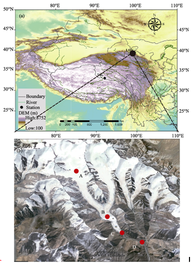
Figure 1 Map showing the location of sampling sites in the Laohugou glacier basin (a), and the sites of snowpits (A), glacier ice (B), runoff at the terminus (C) and runoff 500 m away from the terminus (D) are shown on (b)
δD and δ18O were measured using Picarro L1102-i. Results are reported as relative to Vienna Standard Mean Ocean Water (VSMOW). Measurement precisions for δD and δ18O were better than 0.5 and 0.1‰, respectively. Cations are analyzed by a Dionex-600 Ion Chromatograph and anions with a Dionex-2500 Ion Chromatograph in the Cold and Arid Region Environment and Engineering Research Institute, CAS. The analytical precision reaches 10-9 g mL-1 and the standard deviation is less than 5%. Moreover, the TDS, pH, and EC were also measured with the PHJS-4A and DDSJ-308A.

3 Results and discussion

3.1 Characteristics and composition of stable isotope and chemistry in various water bodies

During the glacier ablation period of June to September in the years 2012 and 2013, we collected continuously the glacier meltwater runoff, snow and ice, and precipitation samples in the LHG basin, and stable isotope and chemistry were measured to find out the composition and difference of various water bodies at the remote alpine sites. The mean values and comparison of δ18O and δD, and various chemical species (e.g. Mg2+, SO42-, and Ca2+) in the glacier meltwater runoff, snow and ice were shown in Table 1. We also analyzed the spatial variation of δ18O and δD in meltwater runoff at the terminus and another site of 500 m down the terminus of the glacier No.12 (see Table 1). The main objective for this work is to find out the stable isotope and chemical constituents change in the glacier meltwater runoff during the ablation period, and the samples in other water bodies (e.g. snow and ice in the glacier surface and snowpits, and precipitation in the glacier terminus at 4260 m) were used to provide comparison with that of the meltwater runoff (see Figure 1b). Result showed that, the highest value for δ18O was -8.87‰, and the lowest value of δ18O was -14.46‰, with a mean of -12.73‰; while the highest value for δD was -65.96‰, and the lowest value of δD was -97.92‰, with a mean of -87.61‰ (Table 1). Meanwhile, the water chemistry of the glacier meltwater runoff showing Ca-Na-HCO3-SO4 type (at the glacier terminus) and Ca-Mg-HCO3-SO4 type (500 m down the terminus) reflected a typical chemical type of water body in the dust source region of Central Asia (Dong et al., 2014a, 2014b). In this work, the chemical composition of various water bodies showed large difference, as the snow pack and ice, and glacier meltwater runoff showed different chemical water types, which probably caused by the physical and chemical weathering and impacts during the glacier meltwater runoff formation and transport process. Large amount of local and regional chemical constituents may have been input to the meltwater, e.g. crustal dust, which may the have affected the variation of chemical components and their concentrations. For example, Mg2+ concentration in snow and ice was much lower than that of glacier meltwater runoff at the terminus (4260 m), which reflected great influence of local crustal input to the meltwater runoff. Moreover, the pH, EC and TDS in various water bodies also presented obvious difference, which showed an increasing trend from high sites to lower sites in the water body, implying significant influence of various chemical species on the meltwater during the meltwater runoff formation process at the glacier basin, and this influence is closely related to the glacier melting extent.
Table 1 Comparison of chemistry of hydrogen and oxygen isotope ratio in the snow and ice, precipitation and runoff in the Laohugou glacier basin
Sample
sites
Elevation
(m)
SO42-
(μg
L-1)
Mg2+
(μg L-1)
Ca2+ (μg L-1) HCO3- (μg L-1) Na+
(μg L-1)
EC (μs cm-1) pH TDS (mg L-1) δ18O
(‰)
δD
(‰)
Chemical
type
Snow
and ice
4500
-5010
2086.6 115.3 2580 2245.6 1044.1 12.2 5.6 21.3 -15.62 -93.7 Ca-Na- HCO3-SO4
Terminus meltwater 4260 5023 2819.1 7313 4703 6910 135 7.39 61.4 -12.7 -87.61 Ca-Na-
HCO3-SO4
500 m
down
terminus
4200 12018 2832 6243.2 5011.5 1326 186.5 7.21 124.3 -13.5 -83.9 Ca-Mg-
HCO3-SO4
In the global atmospheric precipitation, the mean stable isotope of δD and δ18O was generally linear correlated, as the Global Meteorological Water Line (GMWL): δD=8δ18O+10‰. Because of the different climatic and geographic conditions in different regions, the GMWL showed different values for the slope and intercept parameters. The correlation between δD and δ18O in various water bodies of the LHG glacier meltwater showed obvious difference with that of GMWL, and the meltwater runoff at 4260 m showed similar stable isotope result with that of snow and ice on the glacier (Figure 2). The δD and δ18O values in the meltwater runoff were distributed above the GMWL in Figure 2, thus we can infer that the supply of water in the LHG meltwater runoff was mainly originated from snow and ice ablation, and also from atmospheric precipitation. The precipitation stable isotope also distributed above the right side of the GMWL, which implied that the local environment influences δD and δ18O in precipitation (Figure 2). Research of Clark and Fritz has indicated that, in summer of the arid and warmer region, the precipitation effect could cause a decreased slope and intercept of the local meteorological water line (LMWL) because of the evaporation process during raindrop fall in the atmosphere. Compared with the LMWL in the LHG basin, the slope and intercept of δD and δ18O correlation analysis line in the meltwater runoff showed decreased value, which may reflect: (i) obvious regional difference of LMWL, and the terminus meltwater runoff influenced by snow and ice input to the meltwater, and (ii) with the similar value of δD and δ18O in meltwater and snow-ice, the meltwater runoff was largely originated from the snow and ice ablation contribution in the LHG glacier basin. However, in some samples the δD and δ18O values still showed lower than GMWL, which may be caused by the evaporation dynamics effect during meltwater runoff formation process. Heavy isotopes (δ18O and 2H) in water vapor are depleted more easily than lighter isotopes (16O and 1H) as a result of rainfall from a mass of moist air during its long-distance transport. Therefore, δD and δ18O in precipitation become more negative with increasing distance along the transportation path at the same time, parallel fractionation is destroyed owing to kinetic fractionation processes during water evaporation, resulting in differences in the relationship between δD and δ18O (Siegenthaler et al., 1980). As shown in Figure 2, the relationship between δD and δ18O in the meltwater runoff was as below:
δD =6.878 δ18O-4.2‰ (R2=0.7106, P<0.001) (1)
The change of δD and δ18O in the water body at remote glacier basin was usually caused by the moisture source change and evaporation effect (Zhao et al., 2011). In the study site of western Qilian Mountains, the temporal change of stable isotope in the meltwater runoff was probably also affected by those factors. Figure 3 showed the averaged Outgoing Long Wave radiation (ORL) and winds distribution (during 2000-2014) in the LHG basin and surrounding regions. Figure 3a and 3b respectively indicated ORL in summer (May-September) and in winter-spring (October to April of the next year) in 2012-2013, based on the data from NOAA (http://www. esrl.noaa.gov/psd/data/gridded/data.interp_OLR.html), reflecting the atmospheric vertical convection near the land surface caused by cold cloud at the high layers of the atmosphere in the study area (Gao et al., 2013), thus it can be used to analyze the atmospheric vertical convection influence on water stable isotope in the LHG glacier basin of the western Qilian Mountains. Figure 3c showed the mean wind distribution at 600 hPa in the summer of 2000-2014, while Figure 3d showed that in winter-spring 2000-2014 based on the NCEP/NCAR reanalysis data (data from http://www.esrl. noaa.gov/psd/data), which could reflect the atmospheric horizontal convection influence on the water stable isotope at the glacier basin. We find that, the LHG basin was significantly affected by stronger ORL in summer compared to the inland areas of the Tibetan Plateau regions (Figures 3a and 3b), which could influence the stable isotope change in the meltwater and other water body of the basin. Similarly, the ORL was also showing high value in winter at the LHG basin. Such LHG atmospheric conditions may have caused the increased water isotopic fractionation, leading to the δD and δ18O change to large extent in the water body at the LHG glacier basin. However, as the meltwater was largely from the glacier ablation during the summer period, and samples were collected immediately at the terminus after the melting, the water isotopic fractionation effect of the meltwater may be weaker than that of the precipitation. The meltwater δD and δ18O value change could mainly reflect the condition of snow and ice, and the precipitation, and also their relative composition. The strong wind speed (Figure 3a and 3d) in the Tibetan Plateau and Qilian Mountains may have also caused the increased water isotopic fractionation effect at the LHG glacier basin in both summer (for various water bodies) and winter (just for snow accumulation).
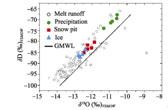
Figure 2 Correlation analysis of hydrogen and oxygen isotope in the Laohugou basin, among which GMWL is δD=8δ18O+10‰
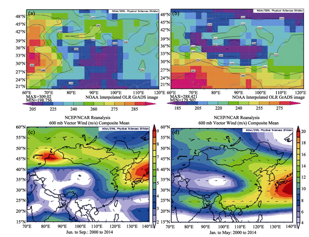
Figure 3 Averaged Outgoing Long Wave radiation (ORL) and winds distribution in the Laohugou and surrounding regions. (a) summer ORL; (b) winter and spring ORL; (c) wind distribution in summer 2000-2014; (d) wind distribution in winter and spring of 2000-2014
Precipitation and air temperature are also important meteorological conditions and parameters for stable isotope research. Air temperature and precipitation change in 2010-2011 at 4200 m sites measured by AWS in the LHG basin were shown in Figure 4. Reference has showed that (Cui et al., 2011), the yearly mean air temperature at the LHG basin was above 0℃, with long winter and extreme low air temperature, and local atmospheric precipitation often occurred during May to September. Moreover, the moisture in this area was mainly originated from the westerly circulation. In summer, as there existed strong atmospheric vertical convection and large amount of precipitation, also with strong glacier ablation, and large amount of snowfall was deposited on the glacier accumulation zone. We can infer that the meltwater stable isotope composition in the glacier runoff was influenced by temporal change of air temperature and precipitation. Precipitation was also an important factor besides air temperature affecting the meltwater δD and δ18O during melting period. Precipitation showed firstly increasing trend and then decreasing trend during May to September (Figure 4), which was highly coincident with the change of air temperature during the ablation period. Moreover, the increased precipitation in July 2012-2013 also caused the increased supply to the meltwater runoff, contributing to the δD and δ18O value change and also to the runoff evolution process change at remote LHG site.
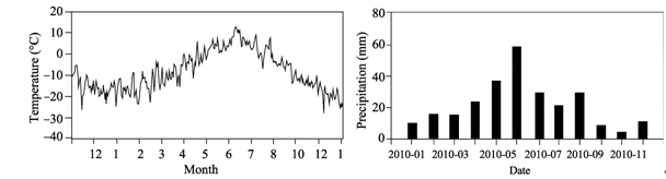
Figure 4 Air temperature and precipitation change in the year 2010-2011 at 4200 m sites in the Laohugou basin
Stable hydrogen and oxygen isotope is important method for water and moisture transportation tracing research. The difference of meltwater runoff transport will lead to the different meltwater chemistry, and the chemical species concentration is affected by the erosion of meltwater runoff and crustal materials, e.g. moraine, cryoconite, and bedrock of the meltwater stream. Moreover, crustal dust from the glacier surface contributes both soluble and insoluble mineral particles to snowpack and meltwater, leading to differences in the fate and transport of associated elements during snowmelt runoff (Bacardit and Camarero, 2010; Gaspari et al., 2006). Figure 5 showed the relative composition of various chemical species in the LHG meltwater runoff, which is similar with the result of Table 1, reflecting the high coincidence of chemical characteristics between the meltwater and other water bodies such as precipitation, snow and ice. The water chemical composition showed a totally Ca-Mg- Na-HCO3 style, in which Ca2+ is the dominant cations in most of the samples, whereas SO42- is also dominant in some samples. Such a chemical composition of various water bodies well reflected the chemical characteristics of a remote glacier basin in the Qilian Mountains of the Central Asian region, where the atmospheric environment is significantly influenced by Asian dust source, often bringing plenty of dust particles to the glacier basin in alpine regions. This chemical composition may have influenced the δD and δ18O variability in various water bodies at the LHG glacier basin, as this change also affected by glacier melting process and extent change.
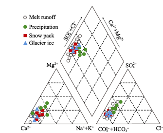
Figure 5 Chemical compositions in the various kinds of water at the Laohugou glacier basin
Figure 6 showed the correlation between δ18O and total dissolved solid (TDS) in various water bodies at the LHG glacier basin. Apparently, we can find out the difference of various water bodies by comparing their correlation. The TDS was larger in the meltwater runoff when compared with similar δ18O value in various water bodies, and the TDS value was lower in the snow and ice at the same period. Such difference was probably caused by the increase of TDS in the meltwater runoff during the meltwater runoff formation process with relatively stable δ18O variability. Such change of chemical composition also reflected the different phases of the meltwater runoff formation process, from snow and ice, precipitation, to the glacier meltwater runoff, with the sites elevations decreasing at the LHG glacier basin. Thus the stable δ18O and physio-chemistry of the water body could together reflect the glacier runoff change process in remote basin.
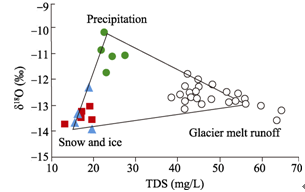
Figure 6 Stable hydrogen and oxygen isotope and TDS correlation analysis in various water sampling sites of the Laohugou basin

3.2 Temporal change of δD and δ18O in various water bodies during ablation period

We find obvious temporal (monthly) change of δD and δ18O in the glacier meltwater runoff at LHG basin in 2012-3013 (Figure 7). With the air temperature rise in June-July, the stable isotope value also showed obvious increasing trend, and the highest air temperature in July.
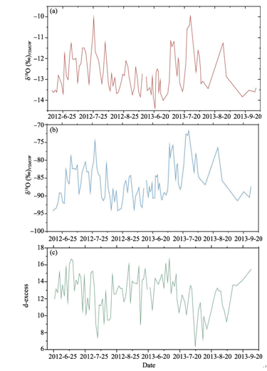
Figure 7 Stable hydrogen and oxygen isotope variation with glacier melting in the summer 2012-2013
As the air temperature began to decrease in the mid-August, the δD and δ18O values also showed significant decreasing trend. Such an obvious monthly change of water stable isotope value indicated the dominant influence of summer air temperature to the meltwater stable isotope in the LHG glacier basin. Previous study has reported such phenomena in the glacier basin. For example, the δ18O record in the precipitation and ice cores of the northern Tibetan Plateau showed the dominant influence of air temperature on the δ18O value in temporal( annual and seasonal) and spatial variation, and the significantly high correlation between δ18O value and air temperature. Observed air temperature by a AWS at the LHG snowpack (with an elevation of 5040 m) also showed good correlation with δ18O record in the snow pit, implying that the δ18O in snow and ice of this area could also reflect “temperature effect”. However, the evident monthly change of δD and δ18O in the glacier meltwater runoff at remote LHG basin indicated stronger signals of climate influence on stable isotope in the western Qilian Mountains. Moreover, such temporal variability was also consistent with snow and ice melting extent during the ablation period, thus could reflect the glacier melting process during June to September.
The d-excess value in various water bodies (including precipitation and river water) is often correlated to the isotopic dynamic fractionation process of moisture during the evaporation occurred, which was mainly controlled by the relative humidity and air temperature of moisture source regions. The d-excess value in meltwater of the LHG glacier basin showed evidently reverse change trend with that of δD and δ18O during 2012-2013, showing decreasing trend in June-July but a sharp increasing trend in August-September. Such variability of d-excess was very consistent in the investigated two years, although with slight difference in values. We think the d-excess change was influenced by snow and ice melting, meltwater runoff, precipitation change, and the relative moisture in the glacier basin. The meltwater runoff process change could directly influence the d-excess, δD and δ18O change, thus reflecting the glacial, meteorological and hydrological change process at remote alpine basin (Figure 7).
Figure 8 Temporal variation of the correlation between stable oxygen isotope and Cl- in the runoff of the Laohugou Glacier No.12
Figure 8 showed the temporal variation of the correlation between stable oxygen isotope and Cl- in the melt runoff of the Laohugou Glacier No.12, in which Figures 8a-8d respectively indicated the composition change of such correlation from June to September. The physical characteristics of meltwater (such as pH, EC, and TDS) also indicated higher value in July with the strongest glacier melting (see Figure 9 and Table 2). Moreover, the temporal change of SPM (suspended particulate matter) had well coincident with TDS in the LHG glacier basin (Dong et al., 2014a). We find that, the temporal change of various chemical species, especially crustal species, e.g. Ca2+, Na+, Mg2+, K+ and Cl- showed good correlation with that of dust particles in meltwater runoff during June to September in 2012-2013 (Table 2), which was probably caused by the glacier melting process. From the above analysis, we can infer that the δD, δ18O and chemical species relative composition (e.g. TDS, pH, EC, Ca2+, Mg2+, Na+, and Cl-) in various water bodies of the LHG glacier basin could reflect the different characteristics of the snow and ice, meltwater stream, and precipitation, and could also reflect the glacier meltwater runoff change process (Figures 8 and 9).
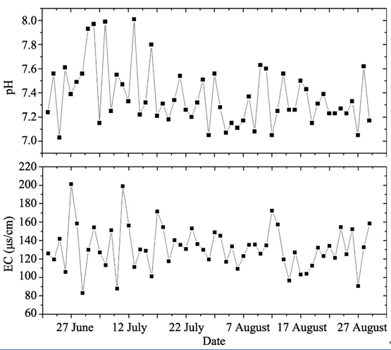
Figure 9 pH and EC variations in the glacier meltwater of the Laohugou glacier basin in summer 2012
Table 2 Chemistry variation with month change in the glacier meltwater runoff in 2013
Sample Time Sample number
(n)
SO42-
(μg L-1)
Mg2+
(μg L-1)
Ca2+ (μg L-1) Cl- (μg L-1) Na (μg L-1) EC (μs cm-1) pH TDS
(mg L-1)
Melt
runoff
June 11 2015.3 982 3214 291 1215 79 7.21 32.1
July 23 5579 2321 4329 113 2145 146 7.32 86.2
August 28 3298.6 3176 3876 342 1137 133 7.43 65.4
September 12 1126.8 874 2569 98 673 65 7.10 43.9

4 Conclusions

Stable hydrogen and oxygen isotope has important implication on water and moisture transportation tracing research, and much work has been done on isotope hydrograph separation for glacier regions around the world. However, little study on stable isotope of glaciers system has been carried out in the western Qilian Mountains of the northeast Tibetan Plateau. Based on hydrogen and oxygen isotope and water chemistry (e.g. major ions, pH, EC, and TDS) measurement during the ablation period, this study discussed the variation and characteristics of stable hydrogen and oxygen isotope, chemistry (e.g. TDS, pH, EC, Ca2+, Mg2+, Na+, and Cl-) in the glacier meltwater, ice and snow, and precipitation at the Laohugou glacier basin. Results showed that, δD and δ18O in the glacier meltwater varied obviously with the temporal change from June to September, with firstly increasing trend and then decreasing trend, showing the highest value in July with the highest air temperature and strong glacier melting, which could indicate the temporal change of glacier melting process and extent. δD and δ18O value in the meltwater were similar with that of snow and ice on the glacier, and were also above the LMWL, which probably implied that the glacier runoff was mainly originated from glacier melting and precipitation supply. The glacier meltwater type of the Laohugou glacier basin were mainly composed by Ca-Na-HCO3-SO4 and Ca-Mg-HCO3-SO4, which also varied with the glacier melting process in summer.
Through analyzing temporal and spatial change of stable hydrogen and oxygen isotope and chemistry in the melting period, we find it is easy to separate each component of water body, e.g. the snow and ice and melt-runoff in the river, which could reflect the change process of glacier melting during the melting period. The δD, δ18O and chemical composition in various water bodies of the LHG glacier basin could reflect the different characteristics of the snow and ice, meltwater stream, and precipitation, and could also reflect the glacier meltwater runoff change process. Thus this work can contribute to the glacier runoff change study of large-scale region by stable isotope and geochemical method in future.

The authors have declared that no competing interests exist.

1
Aravena R, Suzuki O, Pena H.et al., 1999. Isotopic composition and origin of the precipitation in Northern Chile. Appl. Geochem., 14: 411-422.

2
Bacardit M, Camarero L, 2010. Atmospherically deposited major and trace elements in the winter snowpack along a gradient of altitude in the Central Pyrenees: The seasonal record of long-range fluxes over SW Europe.Atmos. Environ., 44: 582-595.

3
Burns D, 2002. Storm flow-hydrograph separation based on isotopes: The thrill is gone-what’s next?Hydrological Process, 16: 1515-1517.

4
Chen H, Li Z Q, Wang P Y.et al., 2015. Five decades of glacier changes in the Hulugou Basin of central Qilian Mountains, Northwest China. Journal of Arid Land, 7(2): 159-165.The Heihe River Basin is the second largest inland river basin in the arid regions of Northwest China. Glaciers account for a large proportion of water resources for production and people's living. Studies of glacier changes and their impact on water resources in the arid lands are of vital importance. A joint expedition was carried out in 2010 for investigating glaciers in the Hulugou Basin, which is located in the upper reaches of Heihe River. Therefore, glacier changes in the Hulugou Basin of central Qilian Mountains during the past 50 years were studied in this study by comparing topographic maps, satellite images, digital elevation models and field observation data in the different periods. Results showed that the total area of the 6 glaciers in the Hulugou Basin decreased by 0.590&plusmn;0.005 km<sup>2</sup> during the period 1956&ndash;2011, corresponding to a loss of 40.7% of the total area in 1956. The average area reduction rate of the 6 glaciers is 0.011 km<sup>2</sup>/a. During the past five decades, the glacier shrinkage was accelerated. The changes in glacier ice surface elevation ranged from &ndash;15 to 3 m with an average thinning of 10&plusmn;8 m or an annual decrease of 0.23&plusmn;0.18 m (0.20&plusmn;0.15 m/a water equivalent) for the period 1956&ndash;2000. The area of Shiyi Glacier in the Hulugou Basin decreased from 0.64 km<sup>2</sup> in 1956 to 0.53 km<sup>2</sup> in 2011 with a reduction rate of 17.2%. The Shiyi Glacier had been divided into two separated glaciers because of severe melting. Com-parative analysis showed that glacier shrinkage in the Hulugou Basin is more serious than that in the other regions of Qilian Mountains.

DOI

5
Chen Z Y, Nie Z L, Zhang G H.et al., 2006. Environmental isotopic study on the recharge and residence time of groundwater in the Heihe River Basin, northwestern China.Hydrogeol J., 14: 1635-1651.lt;a name="Abs1"></a>The recharge and origin of groundwater and its residence time were studied using environmental isotopic measurements in samples from the Heihe River Basin, China. &#948;<sup>18</sup>O and &#948;D values of both river water and groundwater were within the same ranges as those found in the alluvial fan zone, and lay slightly above the local meteoric water line (&#948;D=6.87&#948;<sup>18</sup>O+3.54). This finding indicated that mountain rivers substantially and rapidly contribute to the water resources in the southern and northern sub-basins. &#948;<sup>18</sup>O and &#948;D values of groundwater in the unconfined aquifers of these sub-basins were close to each other. There was evidence of enrichment of heavy isotopes in groundwater due to evaporation. The most pronounced increase in the &#948;<sup>18</sup>O value occurred in agricultural areas, reflecting the admixture of irrigation return flow. Tritium results in groundwater samples from the unconfined aquifers gave evidence for ongoing recharge, with mean residence times of: less than 36&nbsp;years in the alluvial fan zone; about 12&#8211;16&nbsp;years in agricultural areas; and about 26&nbsp;years in the Ejina oasis. In contrast, groundwater in the confined aquifers had <sup>14</sup>C ages between 0 and 10&nbsp;ka<span style="font-variant:small-caps"><small> BP</small></span>.

DOI

6
Dong Zhiwen, Qin Dahe, Chen Jizu.et al., 2014a. Physicochemical impacts of dust particles on alpine glacier melt water at the Laohugou glacier basin in western Qilian Mountains, China.Sci. Total Environ., 493: 930-942.

7
Dong Zhiwen, Qin Dahe, Kang Shichang et al., 2014b. Physicochemical characteristics and sources of atmospheric dust deposition in snow packs on the glaciers of western Qilian Mountains, China. Tellus B, 66: 20956. .

8
Dansgaard W.Stable isotopes in precipitation.Tellus, 1964, 14: 436-468.

9
Gammons C H, Poulson S R, Pellicori D A.et al., 2006. The hydrogen and oxygen isotopic composition of precipitation, evaporated mine water, and river water in Montana, USA.Journal of Hydrology, 328: 319-330.SummaryThe isotopic composition of 42 samples of rain and snow collected in 2004 were used to construct a local meteoric water line (LMWL) for Butte, Montana. The derived equation (δD = 7.31δ O - 7.5, r= 0.987), represents one of the first published LMWLs based on direct precipitation for any location in the northern Rocky Mountains. Samples of underground and surface mine waters in Butte, including the Berkeley pit-lake and a nearby tailings pond, define a linear trend with a much lower slope and intercept than the LMWL (δD = 5.00δ O - 49.5, r= 0.991), consistent with non-equilibrium evaporation at an average relative humidity of roughly 65%. Detailed evaporation calculations are presented which indicate that the shallow Berkeley pit-lake was approximately 25% evaporated in October, 2003, whereas the surface of the tailings pond was at least 50% evaporated. The intersection of the LMWL and mine water evaporation trend was used to calculate the average composition of recharge water to the flooded mine complex (δD = -139‰, δ O = -18.0‰). These values are considerably lighter than the weighted total of precipitation for the 2004 calendar year (δD = -118‰, δ O = -15.3‰), which is partly explained by the unusually low snowfall that Montana experienced in 2004. Based on this study, the LMWL recently proposed by Kendall and Coplen (2001) [Kendall, C., Coplen, T.B., 2001. Distribution of oxygen-18 and deuterium in river waters across the United States, Hydrological Processes 15, 1363-1393] from regression of isotopic data from a number of Montana rivers is more accurately interpreted as an evaporation line. Isotopic trends based on river data should be treated with caution, particularly in a semi-arid region such as Montana where rivers are often influenced by dams and irrigation withdrawals.

DOI

10
Gao Jing, Valerie Masson-Delmotte, Yao Tandong et al., 2013. What controls precipitation δ18O in the southern Tibetan Plateau at seasonal and intra-seasonal scales? A case study at Lhasa and Nyalam. Tellus B, 65: 21043. .

11
Gaspari V, Barbante C, Cozzi G.et al., 2006. Atmospheric iron fluxes over the last deglaciation: Climatic implications.Geophys. Res. Lett., 33: L03704.A decrease in the micronutrient iron supply to the Southern Ocean is widely believed to be involved in the atmospheric COincrease during the last deglaciation. Here we report the first record of atmospheric iron fluxes as determined in 166 samples of the Dome C ice core and covering the last glacial-interglacial transition (22-9 kyr B.P.). It reveals a decrease in fallout flux from 24 脳 10mg Fe myrduring the Last Glacial Maximum to 0.7 脳 10mg Fe myrat the onset of the Holocene. The acid leachable fraction of iron determined in our samples was the 60% of the total iron mass in glacial samples, about twice the value found for Holocene samples. This emerging difference in iron solubility over different climatic stages provides a new insight for evaluating the iron hypothesis over glacial/interglacial periods.

DOI

12
Hou Dianjiong, Qin Xiang, Wu Jingkui.et al., 2012. Isotopic, chemical characteristics and transforming relationship between surface water and ground water in the Xiaochangma River basin.Journal of Glaciology and Geocryology, 34(3): 698-705. (in Chinese)Based on the data of stable isotopes and chemical components in meltwater from the headwater areas and groundwater in the lower reaches of the Xiaochangma River, the characteristics and seasonal variations of isotopes and main ions were analyzed. It is found that the mineralization continuously increases and the type of water chemical component transfers from HCO<sub>3</sub>-Mg-Ca to HCO<sub>3</sub>-SO-4-Ca-Mg from the headwaters to Changma alluvial fan. The coherence of seasonal variations of isotopes indicates that the groundwater in the lower reaches is recharged by the meltwater in upper reaches. Simulation of hydro-geochemical model highlights the water-rock interaction along the flow path. There are deposition reaction of calcite and dissolution reactions of gypsum and halite along the flow path. In addition, dissolution reactions of dolomite, chlorite, illite and hornblende take place as well. A large amount of CO<sub>2</sub> has entered into water. The increasing trend of Cl, SO<sub>4</sub> and Na reveals a deterioration of water quality. This evidence of stable isotopes and hydrochemistry demonstrates a transformation between meltwater in upper reaches and groundwater in the lower reaches of the river.

13
Jouzel J, Merlivat L, 1984. Deuterium and oxygen-18 in precipitation: Modeling of the isotope effects during snow formation.Journal Geophysical Research, 89: 11749-11757.The classical Rayleigh model assuming isotopic equilibrium fails to explain the deuterium and oxygen 18 contents of polar snow. This model leads to too high temperature-isotope gradients (both for δD and δO), to too low δD - δO slopes, and consequently to an excessively large range of deuterium excess values (d = δD - 8δO). We present a new model that takes into account the existence of an isotopic kinetic effect at snow formation as a result of the fact that vapor deposition occurs in an environment supersaturated over ice. This kinetic effect is thoroughly discussed from a microphysical point of view and tested against experimental data and field observations. This new formulation reconciles predicted and observed values both for the temperature-isotope and δD - δDO relationships for reasonable values of supersaturation over ice.

DOI

14
Kong Yanlong, Pang Zhonghe, 2012. Evaluating the sensitivity of glacier rivers to climate change based on hydrograph separation of discharge. Journal of Hydrology, 434: 121-129.The magnitude and variability of water system鈥檚 response to climate change impacts have been assessed through a detailed analysis of discharge composition of two selected typical glacier rivers originated from Tianshan Mountains, Xinjiang Uygur Autonomous Region in West China, which is considered as the water tower of Central Asia. Here we demonstrate climate change in the last 60years using meteorological data (1951鈥2009) in the region. Both of the temperature and precipitation show a remarkable rise before and after year 1990 and these changes are much more significant in North Xinjiang than it is in South Xinjiang. Response of water systems towards climate change is then assessed by comparing annual discharge change of Urumqi River (10.0%) in the North and Kumalak River (38.7%) in South Xinjiang. We found significant inconsistency of the climate change impact on water resources. Furthermore, we quantitatively determine the ratio of ice-melt water using isotope hydrograph separation as well as other conservative tracers. Results show that Urumqi River is recharged by less than 9% of ice-melt water, while Kumalak River contains more than 57% of ice-melt water in their discharges. The extent of glacier input to a water system governs its sensitivity towards climate change. The method has overwhelming potential for un-gauged watersheds and may offer ways of adaptation to climate change in terms of water resources management for flood control and sustainable agriculture.

DOI

15
Merlivat L, Jouzel J, 1979. Global climate interpretation of the deuterium-oxygen 18 relationship for precipitation.Journal Geophysical Research, 84: 5029-5033.A theoretical model is derived to account for the deuterium-oxygen 18 relationship measured in meteoric waters. A steady state regime is assumed for the evaporation of water at the ocean surface and the subsequent formation of precipitation. The calculations show that the deuterium and oxygen 18 content in precipitation can be taken as linearly related. From the slope and the intercept (known as the deuterium excess) of the 未 D -未 18 O linear relationship for precipitation we compute the mean values on a global scale of the evaporating ocean surface temperature and the relative humidity of the air masses overlying the oceans. The deuterium excess is primarly dependent on the mean relative humidity of the air masses formed above the ocean surface. Paleoclimatic data may be obtained by this isotopic method from the analysis of old water and ice samples. A moisture deficit of the air over the ocean, equal to only 10%, in comparison to 20% for modern conditions, is deduced from the deuterium-oxygen 18 distribution measured in groundwater samples older than 20,000 years.

DOI

16
Michael T Hren, Bodo Bookhagen, Peter M Blisniuk.et al., 2009. δ18O and δD of streamwaters across the Himalaya and Tibetan Plateau: Implications for moisture sources and paleoelevation reconstructions.Earth and Planetary Science Letters, 288: 20-32.

17
Qin Xiang, Cui Xiaoqing, Du Wentao.et al., 2015. Variations of the alpine precipitation from an ice core record of the Laohugou glacier basin during 1960-2006 in western Qilian Mountains, China.Journal of Geographical Sciences, 25(2): 165-176.<p>The net accumulation record of ice core is one of the most reliable indicators for reconstructing precipitation changes in high mountains. A 20.12 m ice core was drilled in 2006 from the accumulation zone of Laohugou Glacier No.12 in the northeastern Tibetan Plateau, China. We obtained the precipitation from the ice core net accumulation during 1960-2006, and found out the relationship between Laohugou ice core record and other data from surrounding sites of the northeastern Tibetan Plateau. Results showed that during 1960-2006, the precipitation in the high mountains showed firstly an increasing trend, while during 1980 to 2006 it showed an obvious decreasing trend. Reconstructed precipitation change in the Laohugou glacier basin was consistent with the measured data from the nearby weather stations in the lower mountain of Subei, and the correlation coefficient was 0.619 (<em>P</em>&lt;0.001). However, the precipitation in the high mountain was about 3 times more than that of the lower mountain. The precipitation in Laohugou Glacier No.12 of the western Qilian Mountains corresponded well to the net accumulation of Dunde ice core during the same period, tree-ring reconstructed precipitation, the measured data of multiple meteorological stations in the northeastern Tibetan Plateau, and also the changes of adjacent PDSI drought index. Precipitation changes of the Laohugou glacier basin and other sites of the northeastern Tibetan Plateau had significantly positive correlation with ENSO, which implied that the regional alpine precipitation change was very likely to be influenced by ENSO.</p>

DOI

18
Rozanski K, Araguas-Araguas L, Gonfiantini R, 1993. Isotopic Pattern in Modern Global Precipitation. Washington: American Geophysical Union, 1-37.The International Atomic Energy Agency (IAEA), in cooperation with the World Meteorological Organization (WMO), has been conducting a world-wide survey of hydrogen (H/H) and oxygen (O/O) isotope composition of monthly precipitation since 1961. At present, 72 IAEA/WMO network stations are in operation. Another 82 stations belonging to national organizations continue to send their results to the IAEA for publication. The paper focuses on basic features of spatial and temporal distribution of deuterium and O in global precipitation, as derived from the IAEA/WMO isotope database. The internal structure and basic characteristics of this database are discussed in some detail. The existing phenomenological relationships between observed stable isotope composition of precipitation and various climate-related parameters such as local surface air temperature and amount of precipitation are reviewed and critically assessed. Attempts are presented towards revealing interannual fluctuations in the accumulated isotope records and relating them to changes of precipitation amount and the surface air temperature over the past 30 years.

DOI

19
Siegenthaler U, Oeschger H, 1980. Correlation of δ18O in precipitation with temperature and altitudes.Nature, 285: 314-318.

20
Tian L D, Yao T D, White J W C.et al., 2005. Westerly moisture transport to the middle of Himalayas revealed from the high deuterium excess.Chinese Science Bulletin, 50: 1026-1030.Previous studies found extremely high d-excess in both ice core and glacial melt water in Dasuopu glacier, Xixiabangma, middle of Himalayas. These values are much higher than the global average and those measured in southwest monsoon precipitation. The d-excess variation in over one year at Nyalam station will clarify this phenomenon. Studies show that the high d-excess is related to the seasonal variation of moisture transport to this region. The d-excess values are low during the southwest monsoon active periods, when moisture originated from the humid ocean surface. The d-excess values are higher in non-monsoon months, when moisture is derived from westerly transport. Winter and spring precipitation accounts for a substantial portion of the annual precipitation, resulting in higher d-excess in the yearly precipitation in the middle of Himalayas than other parts of the southern Tibetan Plateau. This finding reveals that the precipitation in the middle of Himalayas is not purely from southwest monsoon, but a large portion from the westerly transport, which is very important for ice core study in this area.

DOI

21
Tian Lide, Yao Tandong, Macclune K.et al., 2007. Stable isotopic variations in west China: A consideration of moisture sources.Journal of Geophysical Research, 112: D10112. doi: 10.1029/2006JD007718.In this study, individual precipitation samples, collected over 2 years at stations in different climatic regions of west China (Tibetan Plateau region, Tianshan region, and Altay) were analyzed for the stable isotopes of precipitation to improve our understanding of how vapor transport impacts the modern stable isotopic distribution. Our results identify regional patterns in both δO and deuterium excess (D excess, defined as δD - 8δO), and in particular we have identified the northward maximum extent of the southwest monsoon over the Tibetan Plateau. This demarcation is also the boundary for the fractionation effect of temperature on stable isotopes in precipitation. The patterns we have identified are as follows: (1) In the southern Tibetan Plateau, along the southern slope of the Himalayas, our results show a distinct seasonality for both δO and D excess as a result of the shift of summer monsoon moisture and winter westerly moisture transport. The signals of δO in the western Tibetan Plateau reveal that the region receives southwest monsoonal moisture. In the east of the plateau, stable isotopic variation shows alternation between monsoon intrusion and recycling of northern moisture. (2) In contrast, in Tianshan there is an apparent "temperature effect" in δO, with enriched values occurring in summer and depleted values occurring in winter. Seasonal D excess values, opposite to those observed in the southern Tibetan Plateau, are controlled by differing seasonal evaporation conditions. (3) In Altay, the most northern mountain region, the seasonal δO shows the same variation with that in Tianshan region. However, D excess shows no apparent seasonal variation.

DOI

22
Cui Xiaoqing, Ren Jiawen, Qin Xiang.et al., 2011. Oxalate, floride record and their environmental significance in Laohugou Glacier No. 12, Qilian Mountains.Environmental Chemistry, 30: 1919e1925. (in Chinese)In June 2006,a 20.12m ice core was obtained at an elevation of 5040 m from the Laohugou Glacier 12,Qilian Mountains,which was dated back to 1960.Oxalate and fluoride historic records were analyzed.The result shows that average oxalate concentration is(18.52±2.4) ng · g-1 in the past 46 years,and its variation is consistent with temperature change,indicating that temperature influences oxalate concentration.The abrupt increase of oxalate concentration since mid 1980′s reflects atmospheric pollution by human and industrial activities.Fluoride in Glacier 12 showed an obvious upward trend since 1980s.Analysis indicated that fluoride in glacier 12 was mainly from the local area,such as fluoride-bearing minerals surrounding Qilian Mountains.Since 1980′s,the rapid increase of fluoride was mainly affected by industrial production activities.

DOI

23
Wang N L, Zhang S B, He J Q.et al., 2009. Tracing the major source area of the mountainous runoff generation of the Heihe River in northwest China using stable isotope technique. Chinese Science Bulletin, 54: 2751-2757.

24
Wu H W, Li X Y, Li J.et al., 2015. Evaporative enrichment of stable isotopes (δ18O and δD) in lake water and the relation to lake-level change of Lake Qinghai, Northeast Tibetan Plateau of China.Journal of Arid Land, 7(5): 623-635.Stable isotopic compositions (&delta;<sup>18</sup>O and &delta;D) have been utilized as a useful indicator for evaluating the current and historical climatic and environmental changes. Therefore, it is vital to understand the relationship between the stable isotopic contents in lake water and the variations of lake level, particularly in Lake Qinghai, China. In this study, we analyzed the variations of isotope compositions (&delta;<sup>18</sup>O, &delta;D and d-excess) in lake water and precipitation by using the samples that were collected from Lake Qinghai region during the period from 2009 to 2012. The results showed that the average isotopic contents of &delta;<sup>18</sup>O and &delta;D in lake water were higher than those in precipitation, which were contrary to the variations of d-excess. The linear regression correlations between &delta;<sup>18</sup>O and &delta;D in lake water and precipitation showed that the local evaporative line (LEL) in lake water (&delta;D=5.88&delta;<sup>18</sup>O&ndash;2.41) deviated significantly from the local meteoric water line (LMWL) in precipitation (&delta;D=8.26&delta;<sup>18</sup>O+16.91), indicating that evaporative enrichment had a significant impact on isotopic contents in lake water. Moreover, we also quantified the E/I ratio (evaporation-to-input ratio) in Lake Qinghai based on the lake water isotopic enrichment model derived from the Rayleigh equation. The changes of E/I ratios (ranging from 0.29 to 0.36 between 2009 and 2012) clearly revealed the shifts of lake levels in Lake Qinghai in recent years. The average E/I ratio of 0.40 reflected that water budget in Lake Qinghai was positive, and consistent with the rising lake levels and the increasing lake areas in many lakes of the Tibetan Plateau. These findings provide some evidences for studying the hydrological balance or water budget by using &delta;<sup>18</sup>O values of lake sedimentary materials and contribute to the reconstruction of paleolake water level and paleoclimate from an isotopic enrichment model in Lake Qinghai.

DOI

25
Zhao Liangju, Yin Li, Xiao Honglang.et al., 2011. Isotopic evidence for the moisture origin and composition of surface runoff in the headwaters of the Heihe River basin.Chinese Sciences Bulletin, 56(4/5): 406-416. (in Chinese)

DOI

26
Zhou S, Nakawo M, Hashimoto S.et al., 2007. The effect of refreezing on the isotopic fractionation of melting snowpack.Hydrological Process, 22(6): 873-882. doi: 10.1002/hyp.6662.

Outlines

/