Research Articles

GIS-based detection of land use transformation in the Loess Plateau: A case study in Baota District, Shaanxi Province, China

  • GUO Liying 1, 2 ,
  • DI Liping , *, 2 ,
  • LI Gang 1, 2 ,
  • LUO Qiyou 1 ,
  • GAO Mingjie 1
Expand
*Corresponding author: Di Liping, PhD and Professor, E-mail:

Received date: 2015-02-26

  Accepted date: 2015-06-20

  Online published: 2015-12-31

Supported by

National Natural Science Foundation of China, No.41130748

Copyright

Journal of Geographical Sciences, All Rights Reserved

Abstract

During the past decade, great efforts have been made to boost the land use transformation in the Loess Plateau, especially for reducing soil erosion by vegetation restoration measures. The Grain-for-Green project (GFG) is the largest ecological rehabilitation program in China, which has a positive impact on the vegetation restoration and sustainable development for the ecologically fragile region of west China. Based on the Landsat TM/ETM images for three time periods (2000, 2005 and 2010), this study applied the GIS technology and a hill-slope analytical model to reveal the spatio-temporal evolutional patterns of returning slope farmland to grassland or woodland in Baota District, Yan’an city of Shaanxi province. Results showed that: (1) from 2000 to 2010, the area of farmland decreased by approximately 35,030 ha, which is the greatest decrease among all the land-use types, whereas grassland, woodland and construction land increased, of which grassland expanded rapidly by 26,380 ha. (2) The annual variation rate of land-use dynamics was 1.98% during the period 2000-2010, of which the rate was 1.05% for the 2000-2005 period and 2.92% for the 2005-2010 period, respectively. Over the past decade, returning farmland to woodland or pastures was the main source of increased grassland and woodland, and the reduction of farmland contributed to the increase in grassland and woodland by 97.39% and 85.28%, respectively. (3) As the terrain slope increases, farmland decreased and woodland and grassland increased significantly. Areas with a slope ranging from 15° to 25° and less than 15° were the focus of the GFG project, accounting for 85% of the total area of farmland reduction. Meanwhile, the reduction in farmland was significant and spatially correlated with the increase in woodland and grassland. (4) Between 2000 and 2010, the area of destruction of grass and trees in grasslands and woodlands for the reclamation of farmland was approximately 4596 ha. The area subject to the GFG policy was 4456 ha with a slope greater than 25° over the decade, but the area of farmland was still 10,357 ha in 2010. Our results indicate that there has still a great potential for returning the steep-slope farmlands to woodlands or grasslands in the Loess Plateau.

Cite this article

GUO Liying , DI Liping , LI Gang , LUO Qiyou , GAO Mingjie . GIS-based detection of land use transformation in the Loess Plateau: A case study in Baota District, Shaanxi Province, China[J]. Journal of Geographical Sciences, 2015 , 25(12) : 1467 -1478 . DOI: 10.1007/s11442-015-1246-z

1 Introduction

Various researches have shown that the land use and cover changes (LUCC) mainly happen in wood, grass, farm and construction land (Tan et al., 2005; Gao et al., 2006; Liu et al., 2008; Liu et al., 2010). But to what extent these changes affect the environment needs to be further evaluated quantitatively (Bonilla et al., 2010; Shao et al., 2011; Lu et al., 2013). The Loess Plateau, a typical area that suffered from the most serious soil erosion in the world, has received much attention from both the government and academia (Ritsema, 2003; Liu et al., 2003; Ostwald and Chen, 2006; Long et al., 2009; Fu et al., 2011; Chen et al., 2013; Hou et al., 2014). It has been evidenced that grassland degradation, desertification and ecological deterioration have seriously affected the sustainable development in China (Di, 2003; Di et al., 2006; Fu et al., 2011; Li et al., 2013). The eco-environmental degradation in the Loess Plateau can be attributed mainly to land reclamation for farming and low vegetation coverage (Fu, 1989; Zhou et al., 2012). To cope with the ever increasing ecological problems, the Grain-for-Green (GFG) project has been implemented in the Loess Plateau by the Chinese Central Government since 1999 (Bennett, 2008; Liu et al., 2014). The GFG advocates three types of land conversion: sloping farmland to grassland, sloping farmland to woodland, and wasteland to woodland. About 27.67 million ha of farmland were converted to woodland from 1999 to 2009, according to the census data from the State Forestry Administration, and the ecological environment of the Loess Plateau has recovered to some extent (Cao et al., 2009; Deng et al., 2012). However, it is unclear the quantity of conversion and transition from sloping farmland to grassland or woodland, especially in the hilly- gullied region.
The soil and water conservation, land use changes and ecological construction in the Loess Plateau have long attracted great attention of the academic community (Cao et al., 2009; Liu et al., 2014). Previous studies on the effects of anthropogenic activities on the environment in the Loess Plateau can be roughly divided into four areas. The first area of research primarily focuses on LUCC and its socio-economic driving force (Guo et al., 2006), and on the rationality and potential of land use changes by different slopes (Shao et al., 2011). The second area of research largely investigates the impact of LUCC on the biome transition zones, the relationships between land use changes and both human activities and climate changes, and the response of soil erosion to LUCC (Feng et al., 2010; Fan et al., 2013; Fan et al., 2015; Xiao et al., 2014). The third area of research mainly examines the influence of human activities on ecosystem, and driving forces of both human activity and climate change to desertification (Ren and Wang, 2007; Wang et al., 2012; Sun et al., 2012). The fourth area of research mainly explores the impact of the GFG on vegetation cover change and the livelihood of farmers, and the effect of gully land consolidation on soil and water conservation as well as ecological protection in the Loess Plateau.
The Loess Plateau is an ecologically fragile region and the key area of the GFG policy in China due to its unique regional characteristics where both soil erosion and the contradiction of man-land relationship were very serious. In the past 10 years, significant changes have taken place in the land use/cover patterns in this region due to the GFG and the Closed Forest policies. Understanding the impact of ecological construction measures on variations and spato-temporal characteristics of vegetation in the hilly area of the Loess Plateau and assessing the rationality of these policies and their future development paths have a great theoretical and practical value in guiding China’s construction of ecological civilization.
Using Baota District of Shaanxi Province as an example, the specific objectives of this study are to 1) explore the spatio-temporal characteristics of LUCC in Baota District in 2000, 2005 and 2010, 2) analyze the flow among different land-use types in recent decade based on the land use transfer matrix, and 3) assess the spatial patterns of farmland changes for different slopes and the effectiveness of returning farmland to woodland or grassland policy. The findings of this study would provide a reference for policymakers in formulating the ecological restoration strategy and the sustainable land use planning in the hilly area of the Loess Plateau, China.

2 Materials and methods

2.1 Study area

Baota District (109°14′10"-110°50′43"E, 36°10′33″-37°2′5″N) is located in the lower reaches of the Yanhe watershed, which lies in the middle part of the Loess Plateau in the northern Shaanxi Province of China, and covers an area of 354,510 ha. It has a typical semiarid continental monsoon climate with an average temperature of 7℃ and an average annual precipitation of 550 mm, of which more than 60% fall from July to September in the form of heavy rains that can cause severe soil erosion. The terrain is a typical loess hilly-gullied landscape with elevations ranging from 860.6 m to 1525 m above sea level (average 1192.8 m). The higher northwest and southwest and the central uplift form a terrain of hill and valley with two ring-like titled to the east (Figure 1).
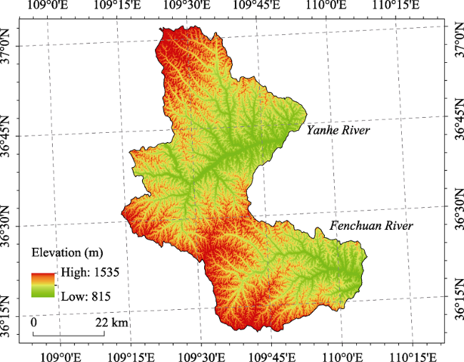
Figure 1 Location of Baota District, Shaanxi Province, China, and its terrain
There is the Yanhe River Basin to the north and the Fenhe River Basin to the south. In this region, the valley geomorphology is well developed with a geographic feature of hills and gullies intertwining, and the gully density is between 3.04 and 5.01 km/km2. Baota District is a rugged and rough region where the area of gullies and ridges accounts for 90% of the whole region, which increases the potential risks of flood in the lower reaches of the Yellow River. The slope of Baota District ranges between 7° and 23°. Baota District shares the typical characteristics of the Loess Plateau including the terrain of hills and gullies, and the fragile ecosystem. Baota District is also one of the key areas of the GFG implementation. Therefore, investigating the impact of the GFG on land use/cover changes in Baota District over the past decade would have an extremely vital practical value for guiding the ecological construction in the Loess Plateau in the future.

2.2 Data acquisition and processing

The land use data used in this study are Landsat TM/ETM images recorded in the 2000, 2005, and 2010 for Baota District. These data were obtained from the Data Center for Resources and Environmental Sciences, Chinese Academy of Sciences (RESDC). Based on the ArcGIS 10 software platform, these vector data were converted into grid data at the grid cell size of 5 m×5 m to ensure data quality and accuracy. The classification scheme of the land use data consisted of six first-level classes and 25 second-level classes. The Raster Reclass module which is a raster reclassification tool in ArcGIS 10 was used to reclassify the rasterized land use into six first-level classes such as farmland, woodland, grassland, water body, construction land, and wasteland, and the spatial database was constructed to store the classification data. Then the Raster Calculator module was used to build up the land use transition matrix. Lastly, we obtained the land use change maps for the 2000-2005 period and for the 2005-2010 period by running the overlay analysis.

2.3 Extraction of hill slope use

In order to evaluate both the land use and the hill-slope land use conversion, the land use changes on different slopes were investigated. Firstly the slope map was generated from a digital elevation model (DEM) constructed from a digital topographic map of 1:50,000 with a 30 m spatial resolution in Baota District using the 3D Analyst Tools of ArcGIS 10. Secondly, the slope maps were segmented into three slope categories: <15°, [15°, 25°) and ≥25°, according to the basic requirements for returning farmland to woodland or grassland. Areas with a slope less than 15° can be used as the main agrarian cultivation areas; areas with a slope between 15°-25° can be arable but need strong engineering measures to prevent soil erosion; and areas with a slope greater than or equal to 25° are not suitable as farmland and need to be returned to woodland and grassland. Thirdly, we overlaid the land use maps with the segmented slope map to extract the corresponding areas of land use/cover changes for the different land use classes on different slopes for various periods (Figure 2). Lastly, based on the aforementioned analysis we further assessed the implementation situation of returning farmland to woodlands or grassland and its rationality.
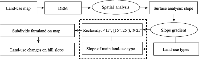
Figure 2 Work flow for land use transformation in this study

2.4 Models

1) The single land-use dynamics
The single land-use dynamics reflect the situation of land use changes with a certain type and at a certain time. The formula is as follows:
where K is the land use change dynamics of one type, T is the study period, and Ua and Ub denote quantity of a certain land-use type in the beginning and end of the study period.
2) The integrated land-use dynamics
The degree of integrated land-use dynamics can be used to describe the rate of regional land use change. The formula is as follows:
where LUi means the land area of types in the beginning of the study period, △LUi-j means the absolute area change of land-use type from the beginning of the study period (i) to the end of the study period (j).
3) The land use transfer matrix
Land use transfer matrix reflects the structure and status of dynamic changes of land-use types in two stages. Transition matrices have often been used to analyze and quantitatively estimate the rate of change. The equation is as follows:
where Sij is the area transited from land-use type i at the beginning of a time period to type j at the end of the time period and n is the number of total land use classes.
Two more indices have been defined in this study to measure the rate of land use change. The first one is the transition rate (Rtij), which is defined as:
Rtij = Sij / Ui ×100% (4)
where Ui is the total area of land-use type i at the beginning of a period, and Sij is the area of land-use type j at the end of the period which was land-use type i at the beginning of the period.
The second one is the contribution rate (Rcij), which is defined as:
Rcij = Sij / Uj ×100% (5)
where Uj is the total area of land-use type i at the end of a period, and Sij is the same as in Equation 4.

3 Results and analysis

3.1 Land use changes

1) Land-use type conversion
Figure 3 shows the land use of the study area in the years 2000, 2005 and 2010, respectively. From the figure we can find that land use change was quite remarkable in Baota District from 2000 to 2010, which was characterized by grassland and woodland expansion and farmland shrinkage (Table 1). During the period from 2000 to 2010, 30,721.14 ha and 7751.43 ha of farmland were converted to grassland and woodland, respectively.
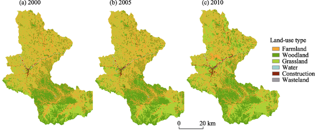
Figure 3 Land use maps of Baota District in 2000, 2005 and 2010
Table 1 The area of different land-use types of Baota District in 2000, 2005 and 2010
Land-use type 2000 2005 2010
Area (ha) % Area (ha) % Area (ha) %
Farmland 137,240 38.71 127,950 36.09 102,210 28.83
Woodland 99,630 28.10 102,460 28.90 106,810 30.13
Grassland 114,690 32.35 120,780 34.07 141,070 39.79
Water 1030 0.29 1050 0.30 1050 0.30
Construction land 1730 0.49 2080 0.59 3320 0.94
Wasteland 190 0.05 190 0.05 50 0.02
Table 1 shows that in 2000, farmland was the main type of land use with an area of approximately 137,240 ha, accounting for 38.71% of the whole region. Grassland was the second largest land-use types with an area of 114,690 ha (32.35%). In 2000, there were approximately 99,630 ha of woodland and 20 ha of wasteland. In 2005, the dominant classes of land use were also farmland (36.09%), grassland (34.07%) and woodland (28.90%), but the areas of farmland shrank by 9,290 ha and of grassland expanded by 6,090 ha, compared to the levels of 2000. By 2010, grassland became the largest land-use type with an area of 14,110 ha (39.79%), while farmland decreased 35,030 ha, the largest decrease in all land-use types from year 2000. During the same period, the areas of grassland, woodland and construction land increased, of which grassland expanded most rapidly with an increase of 26,380 ha.
2) The magnitude of land-use dynamics
The annual variation rate of overall land-use dynamics in Baota District was 1.98% between 2000 and 2010. The annual variation rates were 1.05% and 2.92% for the periods of 2000-2005 and 2005-2010, respectively (Table 2). This result indicated that land use changes in Baota District in the latter period were faster. Among all land-use types during the decade, the areas of farmland and wasteland decreased steadily, whereas the grassland and construction land increased consistently. In terms of the dynamic magnitude of single land-use types, the wasteland had the largest annual decrease of 7.12% over the decade, followed by farmland with an annual decrease of 2.55%, while the construction land and grassland increased 9.18% and 2.30%, respectively. In addition, the changing degree for various types of land use during the period 2005-2010 was larger than that during the period 2000-2005. Among them, the decrease of wasteland was the largest with an annual reduction of 14.23%, followed by farmland with 4.02%, whereas the increase of construction land was the largest with an annual increase of 4.02%, followed by grassland with 3.36%.
Table 2 The dynamic degree of land use in Baota District (%)
Dynamic degree 2000-2005 2005-2010 2000-2010
Integrated dynamic degree 1.05 2.92 1.98
Single
dynamic degree
Farmland -1.35 -4.02 -2.55
Woodland 0.57 0.85 0.72
Grassland 1.06 3.36 2.30
Water 0.38 0.02 0.20
Construction 4.05 11.89 9.18
Wasteland 0.01 -14.23 -7.12

3.2 Land use transitions

A transition matrix was constructed to understand the extent of various types of land use conversion for the periods of 2000-2005 and 2005-2010 (Table 3). Investigating the dynamic change characteristics of various land-use types by calculating the values and probabilities of land use transitions would help to understand clearly the conversion process of land-use types, which would help to recognize the rationality of land use structures. Results demonstrated that during the period of 2000-2010, the area of grassland increased by 31,540 ha, among that 30,720 ha (97.39%) was converted from farmland; woodland increased by 9090 ha, among that 7750 ha (85.28%) was converted from farmland. Over the same period, 4596 ha of grassland and woodland were destroyed for farmland, of which grassland was 3375 ha.
Farmland was mainly converted to grassland and woodland. The area of farmland decreased sharply from 2000 to 2010 by 35,021.88 ha, accounting for 9.88% of the whole region. The decrease of farmland was mainly due to the conversion of farmland to grassland and woodland at the transition rate of 22.39% and 5.65%, respectively. The increase of grassland from 2000 to 2010 was primarily from converted farmland with an area of 26,265.59 ha, which accounted for 7.44% of the whole region. Concurrently, the increase of woodland mainly came from the reduction of farmland with the transition rate of 7.26% (2.02%). However, the changes of construction land, water and wasteland were insignificant during the period 2000-2010 with an annual change rate of 0.88%, -0.19% and -0.04%, respectively. The conversion of farmland to grassland and woodland was the main types of land use transition induced by the GFG.
Table 3 Land use transition (Rt) and contribution rate (Rc) from 2000 to 2010
Area/ha 2000
Farmland Woodland Grassland Water Construction Wasteland Total
2010 Farmland (ha) 97,476.93 7751.43 30,721.14 43.74 1196.55 20.79 137,210.58
Rt (%) 71.04 5.65 22.39 0.03 0.87 0.02
Rc (%) 95.39 7.26 21.78 4.18 36.06 37.68
Woodland (ha) 1221.03 97,686.00 618.57 9.81 62.28 0.27 99,597.96
Rt (%) 1.23 98.08 0.62 0.01 0.06 0.00
Rc (%) 1.19 91.49 0.44 0.94 1.88 0.49
Grassland (ha) 3374.82 1323.81 109,504.44 61.11 417.60 0.90 114,682.68
Rt (%) 2.94 1.15 95.48 0.05 0.36 0.00
Rc (%) 3.30 1.24 77.64 5.84 12.59 1.63
Water (ha) 54.63 1.89 25.56 929.16 12.33 1023.57
Rt (%) 5.34 0.18 2.50 90.78 1.20
Rc (%) 0.05 0.00 0.02 88.79 0.37
Construction (ha) 42.12 11.79 43.74 2.70 1629.27 1729.62
Rt (%) 2.44 0.68 2.53 0.16 94.20
Rc (%) 0.04 0.01 0.03 0.26 49.10
Wasteland (ha) 19.17 134.82 33.21 187.20
Rt (%) 10.24 72.02 17.74
Rc (%) 0.02 0.10 60.20
Total 2010 (ha) 102,188.70 10,6774.92 141,048.27 1046.52 3318.03 55.17 354,431.61
Rate (%) 28.83 30.13 39.80 0.30 0.94 0.02
Net change (ha) -35,021.88 7176.96 26,365.59 -683.10 3130.83 -132.03
Change rate (%) -9.88 2.02 7.44 -0.19 0.88 -0.04

3.3 Gradient differentiation of land use

The terrain slope significantly impacts the agricultural production conditions and field management. Predatory farming on a steep slope leads to increased soil erosion and deterioration of ecological environment and thus disturbs seriously the balance of natural ecosystem. Studying land use/cover changes of farmland on different slopes in the climate- sensitive regions of the Loess Plateau is meaningful on guiding effective land use and the implementation of the GFG project.
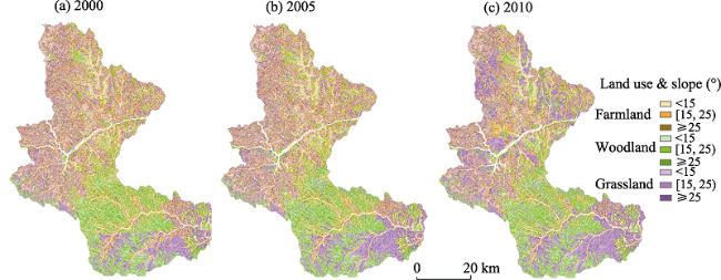
Figure 4 Land use on different slopes of Baota District in 2000, 2005 and 2010
In Baota District, areas with slope less than 15° accounted for 48.6% of the total area, and those with slope between 15° and 25° and greater than 25° accounted for 39.86% and 11.5%, respectively. These terrain characteristics provide a basic condition for the implementation of returning farmland to woodland or grassland.
Figure 4 shows the spatial distribution of various land-use types on different slopes. Woodland was mainly concentrated on the mountainous and hilly areas of the upper reaches of Fenhe River with a slope greater than 25°. Farmland was primarily concentrated on the hilly sloped regions north of the Yanhe River and the Chuandao region along the river, with a slope between 15° and 25°.
Table 4 The changes of main land-use types on different hill slopes in Baota District (ha)
Slope Year Farmland Woodland Grassland Period Farmland change Woodland
change
Grassland
change
<15° 2000 68,783 46,711 54,303 2000-2005 -4.49 1.25 2.98
2005 64,289 47,960 57,285 2005-2010 -10.87 1.47 8.43
2010 53,415 49,429 65,711 2000-2010 -15.36 2.72 14.41
[15°, 25°) 2000 53,549 41,203 46,052 2000-2005 -3.84 1.19 2.57
2005 49,712 42,389 48,623 2005-2010 -11.31 2.19 9.13
2010 38,402 44,579 57,751 2000-2010 -15.15 3.38 11.70
≥25° 2000 14,813 11,607 14,268 2000-2005 -0.93 0.38 0.53
2005 13,875 11,994 14,797 2005-2010 -3.52 0.75 2.77
2010 10,357 12,739 17,565 2000-2010 -4.45 1.03 3.30
There were three main characteristics of land use/cover changes on different slopes in Baota District. Firstly, as the slope increases, the areas of farmland decreased significantly but the woodland and grassland increased obviously from 2000 to 2010. This suggested that the GFG has realized marked achievements. Secondly, the GFG was mainly implemented in regions with the slope between 15° and 25° and less than 15°, accounting for 85% of the total area of farmland reduction (Table 4). Over the past decade, the effect of the GFG was more significant in the period 2005-2010 than that in the period 2000-2005, showing that the areas of farmland reduction in the latter period were 2.8 times that in the previous period, whereas the areas of increased grassland and woodland in the latter period were 3.34 and 1.56 times that in the previous period, respectively. Further investigations indicated that there was a significant spatial correlation between farmland shrinking and the increase in woodland and grassland. These results demonstrated that the increased woodland mainly came from farmland in Baota District over the past decade, and that the reclamation of farmland in the past mainly occurred in the steep areas (Figure 5). These findings also suggested that the GFG still has a great potential for the improvement of ecological environmental in Baota District.
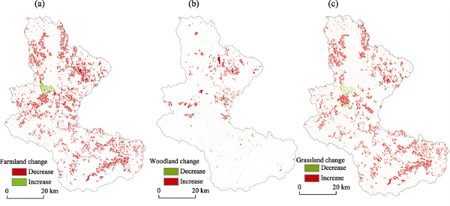
Figure 5 Comparison of the farmland, woodland, and grassland changes of Baota District during 2000-2010

4 Conclusions

(1) Over the period 2000-2010, the area of farmland in Baota District decreased by 35,030 ha, the greatest decrease among all land-use types. Meanwhile, the areas of grassland, woodland and construction land increased, of which grassland expanded most rapidly with an increase of approximately 26,380 ha.
(2) The annual rate of overall land use change in Baota District was 1.98% between 2000 and 2010, of which the rate in the second period (2005-2010) was larger than that in the first period (2000-2005).The conversion of farmland to woodland or grassland was the main driving force for land use changes in the Loess Plateau. Over the past decade, the contribution rate of the GFG to the increase in grassland and woodland were 97.39% and 85.28%, respectively.
(3) Along with slope increases, the areas of farmland decreased significantly but the woodland and grassland increased obviously from 2000 to 2010.The implementation of returning farmland to grassland and woodland has achieved marked accomplishments in Baota District. The GFG was mainly implemented in regions with a slope between 15° and 25° and less than 15°, accounting for 85% of the total area of farmland reduction. Further analysis revealed a significant spatial correlation between farmland reduction and grassland (woodland) increase.
(4) Over the past 10 years, the area of destruction of grasses and trees for the reclamation of farmland was approximately 4596 ha, of which 3375 ha was from the destruction of grasses. This result suggested that problem of destroying the grassland and woodland for farmland reclamation still existed in Baota District. The area subject to the GFG policy was 4456 ha with a slope greater than 25° over the decade, but the area of farmland had still 10,357 ha in 2010. Our findings demonstrated that it is urgent to further work in returning farmland to woodland or grassland on steep slopes and ecological construction in the Loess Plateau in the future.

The authors have declared that no competing interests exist.

1
Bennett M T, 2008. China’s sloping land conversion program: Institutional innovation or business as usual?Ecological Economics, 65(4): 699-711.China's Sloping Land Conversion Program (SLCP) is the largest land retirement/reforestation program in the developing world, having the goal of converting 14.67million hectares of cropland to forests by 2010 (4.4million of which is on land with slopes greater than 25掳) and an additional &ldquo;soft&rdquo; goal of afforesting a roughly equal area of wasteland by 2010. Pending successful completion it could represent a 10&ndash;20% increase in China's national forest area and a 10% decrease in current cultivated area. In contrast to China's other forest-sector policies, SLCP uses a public payment scheme that directly engages millions of rural households as core agents of project implementation, and has the stated principals of volunteerism. Thus, insofar as current or futureprogram implementation involves decentralized, voluntary grassroots participation, SLCP represents an important departure from &ldquo;business as usual&rdquo; in how China manages its forest resources. This work draws upon current available research of the program and uses a 2003 household and village-level survey conducted by the Center for Chinese Agricultural Policy, CAS, to examine program design, implementation and outcomes to date. Results indicate that significant problems in design and implementation exist, with these including shortfalls in subsidies delivered, lack of respect of the principals of volunteerism, and insufficient technical support and budgeting for local implementation costs. More fundamentally, some program goals appear to be based on common misperceptions regarding the linkages between forests and watershed services. Overall, SLCP contains both innovative elements (volunteerism and the direct engagement of farmers) as well as components that hark back to policies and mindsets of decades past (the program's top-down, simplified contract structure, lack of sufficient consultation with local communities and rural households, and campaign-style mobilization). The paper concludes by providing four main suggestions to improve the program: 1) Increase local community input in design and implementation, and ensure that households have full autonomy in participation choice; 2) improve technical support and budgeting for local administrative costs and capacity building; 3) clarify the environmental services targeted and verify the measures needed to acquire these services; and 4) integrate SLCP into an overall package of complementary policies aimed at the rural sector.

DOI

2
Bonilla C A, Reyes J L, Magri A, 2010. Water erosion prediction using the revised universal soil loss equation (RUSLE) in a GIS framework central Chile. Chilean Journal of Agricultural Research, 70(1): 159-169.Soil erosion is a growing problem in Central Chile, particularly in coastal dry lands, where it can significantly decrease the productivity of rainfed agriculture and forestry. In this study, the Revised Universal Soil Loss Equation (RUSLE) was integrated into a Geographic Information System (GIS), and used to evaluate the effects of different combinations of vegetative cover on soil erosion ra...

DOI

3
Cao S, Xu C, Chen Let al., 2009. Attitudes of farmers in China’s northern Shaanxi Province towards the land-use changes required under the Grain for Green Project, and implications for the project’s success.Land Use Policy, 26(4): 1182-1194.<h2 class="secHeading" id="section_abstract">Abstract</h2><p id="">To restore China's degraded environment, the government launched an environmental restoration project named the &ldquo;Grain for Green&rdquo; Project (GGP) in 1999. From 1999 to 2010, the government will spend US$ 40 billion to convert 147 million ha of farmland into forest and grassland and 173 million ha of wasteland (including abandoned farmland) into forest in 25 provinces. A primary focus is to replace farming and livestock grazing in fragile areas with reforestation and planting of forage crops. Given the project's tremendous size and number of participants, the attitudes of the affected farmers will strongly influence the GGP's success. To learn their attitudes, we surveyed 2000 farmers in 2005 to quantify their opinions of the GGP and how it has affected their livelihoods, and we discuss the concerns raised by these attitudes. Farmers appreciated the grain and financial compensation offered by the GGP, but few considered planting of trees (8.9%) or forage species (2.2%) to be a priority. Although only 19.1% felt that their livelihoods had been adversely affected by the GGP and 63.8% supported the project, a large proportion (37.2%) planned to return to cultivating forested areas and grassland once the project's subsidies end in 2018. Therefore, much of the restored vegetation risks being converted into farmland and rangeland again, compromising the sustainability of the environmental achievements. To succeed, strategies such as the GGP must compensate farmers fairly for their costs, create new agricultural products and techniques for use on more suitable land, and create job and training programs that account for the needs and desires of farmers and give them alternatives to returning to old land-use practices.</p>

DOI

4
Chen L, Yang L, et al.Wei W, 2013. Towards sustainable integrated watershed ecosystem management: A case study in Dingxi on the Loess Plateau, China.Environmental Management, 51(1): 126-137.The Chinese government initiated a massive conservation program called "Grain-for-Green'' in 1999 to reduce soil erosion and improve ecosystem function. Implementing practical sustainable development in the loess plateau still remains problematic, particularly in its eco-fragile areas. Here we discussed an approach for sustainable development at the watershed scale by integrating land use suitability, ecosystem services and public participation in the loess hilly area. We linked land use scenario analysis and economic modeling to compare the outcomes of three scenarios, CLU (Current Land Use), GOLU (Grain-production Oriented Land Use) and PSLU (Potential Sustainable Land Use). The results indicated that compared to PSLU, GOLU may provide a higher economic productivity in the short-term, but not in the long-term. CLU ranked lowest in terms of economic benefits and did not meet the daily needs of the local farmers. To reconcile the land use adjustments with farmers' basic needs, a labor-saving land use strategy is necessary. Since the PSLU scenario assumes that slope cropland should be converted to pastures or orchards, more time may be available for off-farm work and for more public participation in integrated ecosystem management. Financial support to the local farmers for environmental conservation should be modulated in function of their positive contribution to ecosystem management.

DOI

5
Deng L, Shangguan Z P, Li R, 2012. Effects of the Grain-for-Green Program on soil erosion in China.International Journal of Sediment Research, 27(1): 120-127.

DOI

6
Di L P, 2003. Recent progresses on remote sensing monitoring of desertification,Annals of Arid Zone, 42(3): 371-392.

7
Di L P, McDonald K, 2006.The NASA HDF-EOS Web GIS Software Suite (NWGISS). In: Qu J et al. (eds.). Earth Science Satellite Remote Sensing. Springer-Verlag.

8
Fan X G, Ma Z G, Yang Qet al., 2015. Land use/land cover changes and regional climate over the Loess Plateau during 2001-2009. Part II: interrelationship from observations.Climatic Change, 129(3/4): 441-455.Afforestation efforts in China resulted in significant changes in vegetation coverage over the Loess Plateau during 2001鈥2009. While regional climate conditions dominate the distribution of major vegetation types, human activities, primarily afforestation/reforestation and the resultant land use/land cover (LULC) changes (LULCC) and their impacts, are the focus of this study. A new attribution method was developed and applied to observed data for investigating the interrelationships between climate variation and LULCC. Regional climate (temperature and precipitation) changes are attributed to climate variation and LULCC; LULCC is attributed to climate variation and human activities. Climate attribution analysis indicated a larger contribution ratio (based on comparison of standard deviations of each contributing factor-induced climate changes and that of total change) from climate variation than from LULCC (0.95 from climate variation vs. 0.35 from LULCC) for variations in temperature. Impacts on precipitation indicated more spatial variations than those on temperature. The spatial variation of LULCC impacts on precipitation implied that human activities might have larger impacts on precipitation in the region鈥檚 arid north than in its humid south. Using both leaf area index (LAI) and areal coverage of each of the major land types, LULCC attribution analysis suggested that LULCC observed in the 2000s resulted primarily from human activities rather than climate variations (0.99 contribution ratio from human activities vs. 0.26 from climate variation).

DOI

9
Fan Z M, Li J, Yue T X, 2013. Land-cover changes of biome transition zones in Loess Plateau of China.Ecological Modelling, 252: 129-140.The Holdridge life zone (HLZ) model has been improved to help classify the biome transition zone (BTZ) in China's Loess Plateau. A positive and negative transformation index of land-cover (PNTIL) was developed to quantitatively evaluate the land-cover changes in every type of BTZ. Three bioclimatic datasets, with a spatial resolution of 1 km x 1 km, were used to classify the BTZ type in Loess Plateau. These include the mean annual biotemperature (MAB), average total annual precipitation (TAP) and potential evapotranspiration ratio (PER). In 1985, 1995 and 2005 land cover data was used to analyze the changes within BTZs. The results show that there are 14 BTZ types, which account for 25.21% of the total land-cover area in Loess Plateau. From 1985 to 2005, cultivated land decreased 0.93% per decade; on average wetland and water areas, woodland and grassland increased 3.47%, 0.24% and 0.06% respectively per decade. During this period the total rate of whole BTZ land-cover transformation decreased from 28.53% to 21.91%. Overall the total positive and negative transformed areas of land cover in BTZs displayed a decreasing trend. Moreover, the results indicate that the transition zones may have exhibited a greater change and landscape diversity than the adjacent biomes in Loess Plateau from 1985 to 2005. (C) 2012 Elsevier B.V. All rights reserved.

DOI

10
Feng X M, Wang Y F, Chen L Det al., 2010. Modeling soil erosion and its response to land-use change in hilly catchments of the Chinese Loess Plateau.Geomorphology, 118: 239-248.Soil erosion is a major environmental problem threatening the sustainable development of the Chinese Loess Plateau. Distributed soil erosion models can be used for studying erosion patterns in relation to alternative land-use conditions, identifying sediment sources, and hence guiding soil and water conservation planning. In this study, we used the WATEM/SEDEM model to predict annual erosion patterns with respect to land-use change within a typical hilly catchment in the Loess Plateau. Soil erosion rates derived from (137)Cs measurements in a nearby catchment were used to calibrate the model. The model's performance was assessed by comparing the simulated erosion pattern with the field observations, based on the model efficiency (ME), relative root mean square error (RRMSE) and kappa statistics. It was found that the WATEM/SEDEM model performs poorly in predicting erosion amounts for each raster cell used for the modeling, but is more reliable in predicting the spatial pattern of erosion. For the entire catchment, the land-use conversions between 1990 and 2005 reduced soil erosion, largely due to the Grain-for-Green project initiated by the Chinese central government. We also compared the contribution of specific land-use types to soil erosion reduction, and addressed the possible influences of land-use policy upon soil erosion. (C) 2010 Elsevier B.V. All rights reserved.

DOI

11
Fu B J, 1989. Soil erosion and its control in the Loess Plateau of China.Soil Use and Management, 5(2): 76-82.Abstract. The loess plateau in China is the most developed region of loess in the world in terms of extent, thickness and depositional sequence. It is also the region with the most serious soil erosion in the world. This paper reviews the factors and reasons for soil erosion in this area. The loess is prone to vertical cleavage and its surface soils are soft and loose. Rainstorms are frequent with intense rain concentrated during the summer. Irrational land use and exploitive management have been carried out for thousands of years and express themselves through the loss of grassland and natural forests. Finally, some soil conservation schemes for use in the loess plateau are suggested.

DOI

12
Fu B J, Liu Y, Yet al., 2011. Assessing the soil erosion control service of ecosystems change in the Loess Plateau of China.Ecological Complexity, 8(4): 284-293.<h2 class="secHeading" id="section_abstract">Abstract</h2><p id="spar0010">Soil erosion in terrestrial ecosystems, as an important global environmental problem, significantly impacts on environmental quality and social economy. By protecting soil from wind and water erosion, terrestrial ecosystems supply human beings with soil erosion control service, one of the fundamental ecosystem services that ensure human welfare. The Loess Plateau was one of the regions in the world that suffered from severe soil erosion. In the past decades, restoration projects were implemented to improve soil erosion control in the region. The Grain-to-Green project, converting slope croplands into forest or grasslands, launched in 1999 was the most massive one. It is needed to assess the change of soil erosion control service brought about by the project. This study evaluated the land cover changes from 2000 to 2008 by satellite image interpretation. Universal Soil Loss Equation (USLE) was employed for the soil erosion control assessment for the same period with localized parameters. Soil retention calculated as potential soil erosion (erosion without vegetation cover) minus actual soil erosion was applied as indicator for soil erosion control service. The results indicate that ecosystem soil erosion control service has been improved from 2000 to 2008 as a result of vegetation restoration. Average soil retention rate (the ratio of soil retention to potential soil loss in percentage) was up to 63.3% during 2000&ndash;2008. Soil loss rate in 34% of the entire plateau decreased, 48% unchanged and 18% slightly increased. Areas suffering from intense erosion shrank and light erosion areas expanded. Zones with slope gradient of 8&deg;&ndash;35&deg; were the main contribution area of soil loss. On average, these zones produced 82% of the total soil loss with 45.5% of the total area in the Loess Plateau. Correspondingly, soil erosion control capacity was significantly improved in these zones. Soil loss rate decreased from 5000&#xA0;t&#xA0;km<sup>&minus;2</sup>&#xA0;yr<sup>&minus;1</sup> to 3600&#xA0;t&#xA0;km<sup>&minus;2</sup>&#xA0;yr<sup>&minus;1</sup> 6900&#xA0;t&#xA0;km<sup>&minus;2</sup>&#xA0;yr<sup>&minus;1</sup> to 4700&#xA0;t&#xA0;km<sup>&minus;2</sup>&#xA0;yr<sup>&minus;1</sup> and 8500&#xA0;t&#xA0;km<sup>&minus;2</sup>&#xA0;yr<sup>&minus;1</sup> to 5500&#xA0;t&#xA0;km<sup>&minus;2</sup>&#xA0;yr<sup>&minus;1</sup> in the zones with slope gradient of 8&deg;&ndash;15&deg; 15&deg;&ndash;25&deg; and 25&deg;&ndash;35&deg; respectively. However, the mean soil erosion rate in areas with slope gradient over 8&deg; was still larger than 3600&#xA0;t&#xA0;km<sup>&minus;2</sup>&#xA0;yr<sup>&minus;1</sup> which is far beyond the tolerable erosion rate of 1000&#xA0;t&#xA0;km<sup>&minus;2</sup>&#xA0;yr<sup>&minus;1</sup>. Thus, soil erosion is still one of the top environmental problems that need more ecological restoration efforts.</p><h4 id="secGabs_N3ac39a50N3ab95ae8">Highlights</h4><p>? The soil erosion control service of regional ecosystems was evaluated based on land cover change and USLE modeling. ? Results indicated that soil erosion control service has been greatly enhanced through vegetation restoration in the Loess Plateau region. ? The spatiotemporal variations of the soil erosion control service were determined, which may be crucial for regional ecological restoration.</p>

DOI

13
Gao J, Liu Y S, Chen Y F, 2006. Land cover changes during agrarian restructuring in Northeast China.Applied Geography, 26(3/4): 312-322.During the last quarter of the 20th century the agrarian sector in China went through a series of reforms. Changes in government policy on land use led to extensive changes in land cover, culminating in the 1990s. These changes were detected from multi-temporal Landsat TM images of 1990, 1995 and 2000 for Northeast China. Overlay of the mapped land cover in ArcInfo showed that farmland and grassland decreased while water, built-up areas, and woodland increased. More than three-quarters of the detected changes occurred during 1990鈥1995. Farmland changed mainly to woodland, water, and built-up areas while woodland and grassland were converted chiefly to farmland. Spatially, the change from woodland to farmland adjoined the margin of natural forests while change in the opposite direction was restricted to the agropastoral west. Paradoxically, reclamation of grassland to farmland also took place in the agropastoral west. These conflicting changes were caused primarily by lack of stability and consistency in the government's land use policies.

DOI

14
Guo L Y, Ren Z Y, Liu Y S, 2006. The causes of land landscape changes in semi-arid area of Northwest China: A case study of Yulin city.Journal of Geographical Sciences, 16(2): 192-198.<a name="Abs1"></a>Rapid land landscape change has taken place in many arid and semi-arid regions such as the vulnerable ecological area over the last decade. In this paper, we quantified land landscape change of Yulin in this area between 1985 and 2000 using remote sensing and GIS. It was found that fallow landscape decreased by 125,148 hm<sup>2</sup> while grassland and woodland increased by 107,975 hm<sup>2</sup> and 17,157 hm<sup>2</sup> respectively. The major factors responsible for these changes are identified as the change in the government policy on preserving the environment, continued growth in mining, and urbanization. The efforts in restoring the deteriorated ecosystem have reaped certain benefits in reducing the spatial extent of sandy land through replacement by non-irrigated farmland, woodland and grassland. On the other hand, continued expansion of mining industry and urbanization has exerted adverse impacts on the land landscape. At present regional economic development conflicts directly with the protection of the natural environment. Such a conflict has caused the destruction to the land resources and fragmentation of the landscape accompanied by land desertification, the case is even serious in some localities.

DOI

15
Hou L, Hoag D, Keske C M Het al., 2014. Sustainable value of degraded soils in China’s Loess Plateau: An updated approach.Ecological Economics, 97: 20-27.China's Loess Plateau is a highly distressed region where intensive crop production has been undermined by high soil erosion rates that threaten the long-term livelihood of its inhabitants. Regional policy goals aim to balance economic performance with the sustainable use of natural resources. From a practical perspective, challenges arise when measuring sustainability levels that mix multiple dimensions, scales, and benchmarks. This study addresses these challenges by comparing the sustainability of agricultural systems across varied crops, land types, and cropping techniques in China's Loess Plateau. Sustainability levels for each system are compared to benchmarks using data envelopment analysis, which is then used to calculate a sustainable value (SV). The SV approach provides a monetary measure of sustainability that includes economic, environmental and social dimensions. Results demonstrate that the most sustainable agricultural systems in the Loess Plateau involve machine intensive cropping systems, a corn17soybean17corn rotation, mulching, furrows ridging, and bench terracing.

DOI

16
Li Y R, Liu Y S, Long H Let al., 2013. Local responses to macro development policies and their effects on rural system in mountainous regions: The case of Shuanghe Village in Sichuan Province.Journal of Mountain Science, 10(4): 588-608.

17
Liu Y S, Fang F, Li Y H, 2014. Key issues of land use in China and implications for policy making.Land Use Policy, 40: 6-12.The paper aims to comprehensively analyze key issues of current land use in China. It identifies the major land-use problems when China is undergoing rapid urbanization. Then, the paper interprets and assesses the related land-use policies: requisition-compensation balance of arable land, increasing vs. decreasing balance of urban-rural built land, reserved land system within land requisition, rural land consolidation and economical and intensive land use. The paper finds that current policies are targeting specific problems while being implemented in parallel. There is lacking a framework that incorporates all the policies. The paper finally indicates the current land-use challenges and proposes strategic land-use policy system to guide sustainable land use in the future.

DOI

18
Liu Y S, Gao J, Yang Y F, 2003. A holistic approach towards assessment of severity of land degradation along the great wall in northern Shaanxi Province, China.Environmental Monitoring and Assessment, 82(2): 187-202.<a name="Abs1"></a>The farming and grazing interlocked transitional zone along theGreat Wall in northern <i>Shaanxi</i> Province is particularly vulnerable to desertification due to its fragile ecosystem and intensive human activity. Studies reveal that desertification isboth a natural and anthropogenic process. Four desertificationindicators (vegetative cover, proportion of drifting sand area, desertification rate, and population pressure) were used to assess the severity of desertification in a GIS. The first threefactors were derived from multitemporal remote sensing and landinventory data. The last factor was calculated from census data.It was found that the overall severity of land degradation in thestudy area has worsened during the last two decades with severely, highly and moderately degraded land accounting for 84.2% of the total area in 1998. While the area affected by desertification has increased, the rate of desertification has also accelerated from 0.74 to 0.87%. Risk of land degradation in the study area has increased, on an average, by 155% since 1985. Incorporation of both natural and anthropogenic factors inthe analysis provides realistic assessment of risk of desertification.

DOI

19
Liu Y S, Guo Y J, Li Y R, 2015. GIS-based effect assessment of soil erosion before and after gully land consolidation: A case study of Wangjiagou Project Region, Loess Plateau.Chinese Geographical Science, 25(2): 137-146.The Loess Plateau is one typical area of serious soil erosion in the world. China has implemented ′Grain for Green′(GFG) project to restore the eco-environment of the Loess Plateau since 1999. With the GFG project subsidy approaching the end, it is concerned that farmers of fewer subsidies may reclaim land again. Thus, ′Gully Land Consolidation Project′(GLCP) was initiated in 2010. The core of the GLCP was to create more land suitable for farming in gullies so as to reduce land reclamation on the slopes which are ecological vulnerable areas. This paper aims to assess the effect of the GLCP on soil erosion problems by studying Wangjiagou project region located in the central part of Anzi valley in the middle of the Loess Plateau, mainly using the revised universal soil loss equation(RUSLE) based on GIS. The findings show that the GLCP can help to reduce soil shipment by 9.87% and it creates more terraces and river-nearby land suitable for farming which account for 27.41% of the whole study area. Thus, it is feasible to implement the GLCP in places below gradient 15°, though the GLCP also intensifies soil erosion in certain places such as field ridge, village land, floodplain, natural grassland, and shrub land. In short, the GLCP develops new generation dam land and balances the short-term and long-term interests to ease the conflicts between economic development and environmental protection. Furthermore, the GLCP and the GFG could also be combined preferably. On the one hand, the GFG improves the ecological environment, which could offer certain safety to the GLCP, on the other hand, the GLCP creates more farmland favorable for farming in gullies instead of land reclamation on the slopes, which could indirectly protect the GFG project.

DOI

20
Liu Y S, Wang L J, Long H L, 2008. Spatio-temporal analysis of land-use conversion in the eastern coastal China during 1996-2005.Journal of Geographical Sciences, 18(3): 274-282.<a name="Abs1"></a>Based on the acquaintance of the regional background of urban-rural transformational development and investigations on the spot, this paper discusses the holistic situation, dominant factors and mechanism of arable land loss and land for construction occupation in the coastal area of China over the last decade, with the aid of GIS technology. Conclusions of the research are summarized as follows: (1) the arable land had been continuously decreasing from 1996 to 2005, with a loss of 1,708,700 hm<sup>2</sup> and an average decrement of 170,900 hm<sup>2</sup> per year; (2) land for construction increased 1,373,700 hm<sup>2</sup> with an average increment of 153,200 hm<sup>2</sup> per year; (3) total area of encroachment on arable land for construction between 1996 and 2005 was 1,053,100 hm<sup>2</sup> accounting for 34.03% of the arable land loss in the same period, the percentages of which used for industrial land (INL), transportation land (TRL), rural construction land (RUL) and town construction land (TOL) are 45.03%, 15.8%, 15.47% and 11.5%, respectively; and (4) the fluctuation of the increase of construction land and encroachment on arable land in the area were deeply influenced by the nation&#8217;s macroscopic land-use policies and development level of regional economy. The growth of population and advancement of technology promoted the rapid industrialization, construction of transportation infrastructures, rural urbanization and expansion of rural settlements in the eastern coastal area, and therefore were the primary driving forces of land-use conversion.

DOI

21
Liu Y S, Zhang Y Y, Guo L Y, 2010. Towards realistic assessment of cultivated land quality in an ecologically fragile environment: A satellite imagery-based approach.Applied Geography, 30(2): 271-281.<h2 class="secHeading" id="section_abstract">Abstract</h2><p id="">It is very difficult to realistically assess cultivated land quality (CLQ) because its contributing factors cannot be accurately quantified. This study aims at overcoming this difficulty by using information objectively derivable from ETM+ and SPOT images for Hengshan County, Northwest China. This objective approach is able to yield a comprehensive CLQ assessment using five proposed indicators. They are slope gradient, proportion of sandy land, water availability, soil fertility, and land use types organized into three indices of pressure resistance, land state, and land use response. Therefore, this assessment takes into consideration topographic setting, land degradation risk, moisture, vegetation growing condition, and land use response of farmers. The developed CLQ is found to be significantly correlated with the spatial distribution of water resources, suggesting that water availability is a decisive factor influencing land productivity. CLQ is also correlated closely with rural economic level, agricultural infrastructure investment, and the farming system. The whole County was further classified into three cultivated land use zones based on the calculated CLQ value. Each zone is best used for different purposes and requires different strategies of protection. Such assessment outcomes are essential for the prevention of land degradation and adjustment of agricultural structure to promote sustainable use of cultivated land.</p>

DOI

22
Long H L, Liu Y S, Wu X Qet al., 2009. Spatio-temporal dynamic patterns of farmland and rural settlements in Su-Xi-Chang region: Implications for building a new countryside in coastal China.Land Use Policy, 26(2): 322-333.<h2 class="secHeading" id="section_abstract">Abstract</h2><p id="">This paper analyzes the spatio-temporal dynamic patterns of farmland and rural settlements from 1990 to 2006 in Su&ndash;Xi&ndash;Chang region of coastal China experienced dramatic economic and spatial restructuring, using high-resolution Landsat TM (Thematic Mapper) data in 1990, 1995, 2000 and 2006, and socio-economic data from both research institutes and government departments. To examine the spatial patterns of farmland and rural settlements and their change over time, a set of pattern metrics that capture different dimensions of land fragmentation was identified. The outcomes indicated that, to a large extent, land-use change from 1990 to 2006 in Su&ndash;Xi&ndash;Chang region was characterized by a serious replacement of farmland with urban and rural settlements, construction land, and artificial ponds. Population growth, rapid industrialization and urbanization are the major driving forces of farmland change, and China's economic reforms played an important role in the transformation of rural settlements. China's &ldquo;<em>building a new countryside</em>&rdquo; is an epoch-making countryside planning policy. The focuses of building a new countryside in coastal China need to be concentrated on protecting the farmland, developing modern agriculture, and building &ldquo;clean and tidy villages.&rdquo; Rural construction land consolidation and cultivated land consolidation are two important ways to achieve the building objectives. The authors argue that it is fundamental to lay out a scientific urban&ndash;rural integrated development planning for building a new countryside, which needs to pay more attention to making the rural have certain functions serving for the urban. In addition, the cultural elements of idyll and the rural landscape need to be reserved and respected in the process of building a new countryside in coastal China, instead of building a new countryside, which looks more like a city.</p>

DOI

23
Lu S S, Liu Y S, Long H L, 2013. Agricultural production structure optimization: A case study of major grain producing area, China.Journal of Integrative Agriculture, 12(1): 184-197.A large number of mathematical models were developed for supporting agricultural production structure optimization decisions; however, few of them can address various uncertainties existing in many factors (e.g., eco-social benefit maximization, food security, employment stability and ecosystem balance). In this study, an interval-probabilistic agricultural production structure optimization model (IPAPSOM) is formulated for tackling uncertainty presented as discrete intervals and/or probability distribution. The developed model improves upon the existing probabilistic programming and inexact optimization approaches. The IPAPSOM considers not only food security policy constraints, but also involves rural households&rsquo; income increase and eco-environmental conversation, which can effectively reflect various interrelations among different aspects in an agricultural production structure optimization system. Moreover, it can also help examine the reliability of satisfying (or risk of violating) system constraints under uncertainty. The model is applied to a real case of long-term agricultural production structure optimization in Dancheng County, which is located in Henan Province of Central China as one of the major grain producing areas. Interval solutions associated with different risk levels of constraint violation are obtained. The results are useful for generating a range of decision alternatives under various system benefit conditions, and thus helping decision makers to identify the desired agricultural production structure optimization strategy under uncertainty.

DOI

24
Ostwald M, Chen D, 2006. Land-use change: Impacts of climate variations and policies among small-scale farmers in the Loess Plateau, China.Land Use Policy, 23(4): 361-371.

25
Ren Z Y, Wang L X, 2007. Spatio-temporal differentiation of landscape ecological niche in western ecological frangible region: A case study of Yan’an region in northwestern China.Journal of Geographical Sciences, 17(4): 479-486.<a name="Abs1"></a>In this study, we attempt to put forward a conception of landscape ecological niche, enlightened by international scholars on extending the ecological niche theory from spatial niche to functional niche. That is helpful for comprehensively appraising landscape spatial patterns and ecological functions, also, presents a new method for analyzing landscape features from multidimensional aspects. The practice process is demonstrated by taking Yan&#8217;an region in northwestern China as a case. Firstly, the indices system including spatial attribute and functional attribute is established for assessing landscape ecological niche. Additionally, two-dimensional figures are drawn for comparing the spatio-temporal features of landscape ecological niche in 1987 and 2000 among the 13 administrative counties. The results show that from 1987 to 2000, towards Yan&#8217;an region, spatial attribute value of landscape ecological niche changes from 1.000 to 1.178 with an obvious increment, and functional attribute value changes from 0.989 to 1.069 with a little increment, both of which enhance the regional landscape ecological niche. Towards each county, spatial attribute value of landscape ecological niche increases to different extent while functional attribute value changes dissimilarly with an increment or a decrement.

DOI

26
Ritsema C J, 2003.Introduction: Soil erosion and participatory land use planning on the Loess Plateau in China.Catena, 54(1): 1-5.Working on the evolution of the Croatian shoreline (FOUACHE et al. 2000) we try to correlate geomorphological and archaeological markers. A submerged notch was found 0.5 in below the present sea level on many diving points, between Porec and Zadar, as well as on the islands of Rab and Pag. A number of submerged archaeological remnants on the Istria and Kvarner area give evidence that the notch corresponds to the sea level in Roman times, 2000 years ago. From the Zadar-Sibenik area the submerged archaeological remnants point to a submersion of at least 1.5 in. Those results could not be correlated with a geomorphological marker due to the lack of a notch. Continuing further to the south till the Prevlaka area neither geomorphological, nor appropriate archaeological markers, have been found. These facts raise the problem of tectonic influence on the above observations. In this study we present the recent structural relations in the studied area and discuss some aspects of tectonic influence on sea level change. The existence of the three sections of the Adriatic microplate, with a different size and a different rate of movement together with the major rock masses in the Dinarides that resist the movement of the microplate, determines the present seismotectonicaly active zones (ALJINOVIC 1984, KUK et al. 2000) in the area. According to geomorphologic, archaeological, structural, seismic, positioning (GPS) and tide-gauge data we distinguish three main areas showing some homogenous properties. The Istria and Kvarner region shows a predominance of the eustatic component in the relative sea level change, while the Zadar-Sibenik and Sibenik-Prevlaka areas point to tectonic movements on which fluctuations in eustatic sea level are superimposed.

DOI

27
Shao H, Gao J E, Wang Fet al., 2011. The GIS assessment of changes in land use covers and hill slope conversion potential in the Loess Plateau.African Journal of Agricultural Research, 6(18): 4199-4209.中国科学院机构知识库(中国科学院机构知识库网格(CAS IR GRID))以发展机构知识能力和知识管理能力为目标,快速实现对本机构知识资产的收集、长期保存、合理传播利用,积极建设对知识内容进行捕获、转化、传播、利用和审计的能力,逐步建设包括知识内容分析、关系分析和能力审计在内的知识服务能力,开展综合知识管理。

DOI

28
Su C H, Fu B J, He C Set al., 2010. Variation of ecosystem services and human activities: A case study in the Yanhe Watershed of China.Acta Oecologica, 44: 46-57.ABSTRACT The concept of &lsquo;ecosystem service&rsquo; provides cohesive views on mechanisms by which nature contributes to human well-being. Fast social and economic development calls for research on interactions between human and natural systems. We took the Yanhe Watershed as our study area, and valued the variation of ecosystem services and human activities of 2000 and 2008. Five ecosystem services were selected i.e. net primary production (NPP), carbon sequestration and oxygen production (CSOP), water conservation, soil conservation, and grain production. Human activity was represented by a composite human activity index (HAI) that integrates human population density, farmland ratio, influence of residential sites and road network. Analysis results of the five ecosystem services and human activity (HAI) are as follows: (i) NPP, CSOP, water conservation, and soil conservation increased from 2000 to 2008, while grain production declined. HAI decreased from 2000 to 2008. Spatially, NPP, CSOP, and water conservation in 2000 and 2008 roughly demonstrated a pattern of decline from south to north, while grain production shows an endocentric increasing spatial pattern. Soil conservation showed a spatial pattern of high in the south and low in the north in 2000 and a different pattern of high in the west and low in the east in 2008 respectively. HAI is proportional to the administrative level and economic development. Variation of NPP/CSOP between 2000 and 2008 show an increasing spatial pattern from northwest to southeast. In contrast, the variation of soil conservation shows an increasing pattern from southeast to northwest. Variation of water conservation shows a fanning out decreasing pattern. Variation of grain production doesn&rsquo;t show conspicuous spatial pattern. (ii) Variation of water conservation and of soil conservation is significantly positively correlated at 0.01 level. Both variations of water conservation and soil conservation are negatively correlated with variation of HAI at 0.01 level. Variations of NPP/CSOP are negatively correlated with variations of soil conservation and grain production at 0.05 level. (iii) Strong tradeoffs exist between regulation services and provision service, while synergies exist within regulation services. Driving effect of human activities on ecosystem services and tradeoffs and synergies among ecosystem service are also discussed.

DOI

29
Tan M H, Li X B, Xie H, 2005. Urban land expansion and arable land loss in China: A case study of Beijing-Tianjin-Hebei region.Land Use Policy, 22(3): 187-196.With significant economic development in the last decade in China, urban land has increasingly expanded and encroached upon arable land in the last decade. Although many papers have analyzed the characteristics of urban land expansion, relatively less attention has been paid to examining the different expansion features of different-tier cities at a regional level. This paper analyzes the spatio-temporal differences of urban land expansion and arable land loss among different-tier cities of the BTH (Beijing鈥揟ianjin鈥揌ebei) region in China in the 1990s, and identifies social, economic, political and spatial factors that led to these differences. Based on urban land change data determined by interpreting Landsat Thematic Mapper (TM) imagery, it was found that the urban land area in the BTH region expanded by 71% between 1990 and 2000. Different-tier cites, however, had enormous differences in urban development, such as speed of urban land expansion, speed of urban land per capita growth, and so on. These differences were closely related to rapid economic development, strict household registration systems, urban development guidelines ( chengshi fazhan fangzhen ), and national land use policies. Of all the new urban land, about 74% was converted from arable land, and there was a general tendency for smaller cities to have higher percentages. One of the important reasons for this result is that urban land is highly correlated with arable land in spatial distribution.

DOI

30
Wang T, Sun J G, Han Het al., 2012.The relative role of climate change and human activities in the desertification process in Yulin region of Northwest China.Environmental Monitoring and Assessment, 184(12): 7165-7173.Abstract<br/>To overcome the shortcoming of existing studies, this paper put forward a statistical vegetation–climate relationship model with integrated temporal and spatial characteristics. Based on this model, we quantitatively discriminated on the grid scale the relative role of climate change and human activities in the desertification dynamics from 1986 to 2000 in Yulin region. Yulin region’s desertification development occurred mainly in the southern hilly and gully area and its reverse in the northwest sand and marsh area. This spatial pattern was especially evident and has never changed thoroughly. From the first time section (1986–1990) to the second (1991–1995), the desertification was developing as a whole, and either in the desertification development district or in the reverse district human activities’ role was always occupying an overwhelmingly dominant position (they were 98.7% and 101.4%, respectively), the role of climate change was extremely slight. From the second time section (1991–1995) to the third (1996–2000), the desertification process was reaching a state of stability, in the desertification development district the role of climate change was nearly equivalent to that of human activities (they were 46.2% and 53.8% separately), and yet in the desertification reverse district, the role of human activities came up to 119.0%, the role of climate change amounted to −19.0%. In addition, the relative role of climate change and human activities possessed great spatial heterogeneity. The above conclusion rather coincides with the qualitative analysis in many literatures, which indicates that this method has certain rationality and can be utilized as a reference for the monitoring and studying of desertification in other areas.<br/>

DOI

31
Xiao L, Xue S, Liu G Bet al., 2014. Fractal features of soil profiles under different land use patterns on the Loess Plateau, China.Journal of Arid Land, 6(5): 550-560.Fractal theory is becoming an increasingly useful tool to describe soil structure dynamics for a better understanding of the performance of soil systems. Changes in land use patterns significantly affect soil physical, chemical and biological properties. However, limited information is available on the fractal characteristics of deep soil layers under different land use patterns. In this study, the fractal dimensions of particle size distribution (PSD) and micro-aggregates in the 0&ndash;500 cm soil profile and soil anti-erodibility in the 0&ndash;10 cm soil profile for 10 typical land use patterns were investigated in the Zhifanggou Watershed on the Loess Plateau, China. The 10 typical land use patterns were: slope cropland, two terraced croplands, check-dam cropland, woodland, two shrublands, orchard, artificial and natural grasslands. The results showed that the fractal dimensions of PSD and micro-aggregates were all significantly influenced by soil depths, land use patterns and their interaction. The planta-tions of shrubland, woodland and natural grassland increased the amount of larger micro-aggregates, and decreased the fractal dimensions of micro-aggregates in the 0&ndash;40 cm soil profile. And they also improved the aggregate state and aggregate degree and decreased dispersion rate in the 0&ndash;10 cm soil profile. The results indicated that fractal theory can be used to characterize soil structure under different land use patterns and fractal dimensions of micro-aggregates were more effective in this regard. The natural grassland may be the best choice for improving soil structure in the study area.

DOI

32
Zhen N H, Fu B J, Lü Y Het al., 2014. Changes of livelihood due to land use shifts: A case study of Yanchang County in the Loess Plateau of China.Land Use Policy, 40: 28-35.Studies of land use policies are commonly based on the environmental impacts or on people's direct responses to the policies. However, research on the impact of policy implementation on people's livelihood and activities and the subsequent economic development of an area is incomplete. We selected Yanchang County as an example to track land use changes and their effects on the livelihood of the local population following the implementation of a new land use policy known as the Grain for Green Project (GGP). The data were collected from statistical yearbooks, questionnaire surveys, and satellite imagery from 1990, 2000, and 2008. We found that dramatic land use changes have occurred in Yanchang County. The vegetation coverage improved significantly from 1990 to 2008, as the grassland and forest areas increased from 44.1% to 60.1% and from 17.7% to 18.4% of the total land area, respectively. The cultivated land declined from 37.3% to 20.7%. With the agricultural area and grain production decreasing from 64×10tons to slightly over 20×10tons per year, an increasing number of local people sought employment in towns and cities. The non-farm income increased, and the local income structure shifted. Migrant and orchard worker income contributed the most to the balance of the total household income. We narrowed our focus to discuss how the GGP accelerated the changes in the participants’ lifestyles and what might be done to sustain the long-term effects of the GGP. While the GGP has brought about considerable environmental benefits, a comprehensive study of environmental–social systems is still needed to achieve a more efficient land use policy. The research results presented in this paper demonstrate that changes in land use and people's activities were triggered by policy changes. We aim to pave the way for studies on the “policy-land-use-social development” chain and to provide references for new policies.

DOI

33
Zhou D, Zhao S, Zhu C, 2012. The Grain for Green Project induced land cover change in the Loess Plateau: A case study with Ansai County, Shanxi Province, China.Ecological Indicators, 23: 88-94.The Grain for Green Project (GGP) is the largest land retirement/afforestation program in China; it was primarily initiated to reduce the soil erosion and improve the ecological conditions in the Loess Plateau in 1999. If effective, this massive regional effort will induce significant improvement in the vegetation conditions. At this time, the effectiveness of the GGP has not been well documented. Using Ansai County as a case study, we characterized the impact of the GGP on the land covers and landscape characteristics of this area by using multi-temporal Landsat MSS, TM and ETM+ images of 1978, 1990, 1995, 2000, 2005 and 2010. The results indicate that the land cover patterns and landscape characteristics in the county were greatly altered in a considerably short period. The implementation of the GGP increased the newly forested land substantially to 21.4% of the study area by 2010 at the cost of both cropland and shrub鈥揼rassland, which decreased by 46.3% and 18.8%, respectively, from 1995 to 2010. Consequently, the coverage of forested land (both older forest and newly forested land) increased from 12.4% in 1995 to 37.7% in 2010. Moreover, the GGP increased landscape fragmentation as indicated by a decreasing mean patch size and changes in class-level landscape indicators varied with land cover categories. The GGP induced improvement in vegetation conditions may benefit soil erosion alleviation and carbon sequestration in the Loess Plateau. However, the potential for the GGP to provide long-term positive ecological effects requires further study.

DOI

34
Zhou H J, Rompaey AV, Wang J A, 2009. Detecting the impact of the Grain for Green program on the mean annual vegetation cover in the Shaanxi province, China using SPOT-VGT NDVI data.Land Use Policy, 26: 954-960.lt;h2 class="secHeading" id="section_abstract">Abstract</h2><p id="">In order to reduce the soil erosion rate on the Chinese Loess Plateau, the Chinese government launched in 1999 the &ldquo;Grain for Green&rdquo; program (GfG). The objective of this program was to increase the forest cover on steep slopes in the landscape by planting trees and sowing grasses on former cropland. The program was a massive investment by the Chinese government. By the end of 2005 the GfG-program was implemented in an area of 87,000&#xA0;km<sup>2</sup> in which about 400&ndash;600 million trees were planted. At present it is not known to what extent this program was successful. This paper examines the effects of the GfG-program on the mean annual vegetation cover in the Shaanxi province. A decadal time series of SPOT VEGETATION imagery from 1998 till 2005 were used to calculate NDVI-values in four counties with different rainfall regimes. By means of a regression between preceding rainfall and NDVI-values the effects of rainfall variability were filtered out. A trend analysis of the corrected NDVI time series pointed out that the GfG-program resulted in a significant increase of the vegetation cover on farmland in the northern part of Shaanxi province. In the southern part of the province, which has a more humid climate and large areas of irrigation farmland no significant increase of the vegetation cover on farmland could be detected.</p>

DOI

Outlines

/