Orginal Article

Land suitability assessment for post-earthquake reconstruction: A case study of Lushan in Sichuan, China

  • TANG Qing , 1, 2 ,
  • LI Yang 3 ,
  • XU Yong , 1, 2, *
Expand
  • 1. Key Laboratory of Regional Sustainable Development Modeling, Institute of Geographic Sciences and Natural Resources Research, CAS, Beijing 100101, China
  • 2. Institute of Geographic Sciences and Natural Resources Research, CAS, Beijing 100101, China
  • 3. China Center for Modernization Research, CAS, Beijing 100190, China

*Corresponding author: Xu Yong, Professor, specialized in human-environment interactions and regional development. E-mail:

Author: Tang Qing, PhD, specialized in land use and regional sustainable development. E-mail:

Received date: 2014-12-05

  Accepted date: 2015-01-20

  Online published: 2015-06-24

Supported by

National Natural Science Foundation of China, No.41301121, No.41430636, No.41171449

Science and Technology Service Network Initiative of the Chinese Academy of Sciences, No.KFJ-EW-STS-003

The Key Research Program of the Chinese Academy of Sciences, No.KZZD-EW-06-01

Copyright

Journal of Geographical Sciences, All Rights Reserved

Abstract

Land suitability assessment (LSA) is one of the key processes of land-use planning. Given its particularity of land suitability assessment for post-earthquake reconstruction, this paper takes into account geological conditions, risk of disasters, water and land resources conditions, and eco-environmental suitability and emphasizes safety factor in the assessment. Taking the April 20, 2013 Mw 6.6 Lushan earthquake as a case, this assessment establishes factors system, uses GIS spatial analysis techniques and data of geology, topography, resources, and eco-environment to evaluate the land suitability for reconstruction. The results show that: (1) the spatial characteristics of land suitability for reconstruction at grid scale and administrative scale manifest that most of the piedmont plains in the east are suitable for large-scale population aggregation, industrialization, and urbanization development; and (2) for the six hard-hit counties, Mingshan is the preferred region for large-scale post-earthquake reconstruction due to its high construction index and suitable land per capita, and some plots of land in the valleys could be selected for in-situ small-scale reconstruction in Lushan. The land suitability assessment for post-earthquake reconstruction would be significant to making sound reconstruction planning for achieving sustainable regional development in the Mw 6.6 Lushan earthquake stricken area. This study could be used as a reference for the regions with similar events.

Cite this article

TANG Qing , LI Yang , XU Yong . Land suitability assessment for post-earthquake reconstruction: A case study of Lushan in Sichuan, China[J]. Journal of Geographical Sciences, 2015 , 25(7) : 865 -878 . DOI: 10.1007/s11442-015-1207-6

1 Introduction

Land suitability assessment (LSA) is one of the key processes of land-use planning (Yu et al., 2011). LSA implies the process of appraisal and grouping of specific areas of land in terms of their suitability for defined uses (Liu et al., 2006), and indicates the suitability of a given type of land to support a defined land use, either in its current state or improvements afterwards (Gong et al., 2012). This assessment can be identified as a multi-criteria evaluation (MCE) approach for the large number of factors are involved in the decision making (Reshmidevi et al., 2009). LSA plays an important role in allocating different types of land resources to appropriate uses, shaping urban development to create a sound urban environment, and alleviating the negative effects of development on ecosystems (Nuissl et al., 2009). Meeting the demands of development with minimal destruction to ecosystems has always been a challenge in urban construction. It is important to consider eco-environmental factors in evaluating the suitability level of urban construction land. For the post-earthquake reconstruction, geological hazards, engineering geology, and hydrological geology are also taken into account in the land suitability assessment in order to achieve both appropriate uses of land resources and secure layout of reconstructive buildings.
The April 20, 2013 Mw 6.6 Lushan earthquake (USGS, 2013) occurred in the Longmen mountain fold-and-thrust belt, Sichuan, China, close to the devastating 2008 Mw 7.9 Wenchuan earthquake that happened five years ago (Li et al., 2014). The Lushan earthquake happened in the Longmen mountain fault zone along the eastern margin of the Tibetan Plateau. The fault zone strikes NE to SW with a length of 500 km and a width of about 40-50 km (Shi et al., 2014). The Lushan earthquake caused about 200 deaths, 11 thousand injuries, and tremendous economic loss. The event aroused great concern from China’s central and local governments, academic institutions, public, and international organizations.Prior to a sound post-earthquake reconstruction planning, the land suitability assessment of the stricken area is essential, because it could not only reveal the physical geographical features but also provide scientific references for the reconstruction site selection. Actually, the land suitability assessment made a great contribution to the development of “The State Overall Planning for Post Lushan Earthquake Reconstruction” released on July 6, 2013.
The urban environmental engineering and geological quality assessment have been adequately addressed by employing multivariate statistical analysis and GIS (Matula, 1981; Cross, 2002; Lee et al., 2004; Sarkar et al., 2007). Researchers have also studied the urban land suitability analysis by means of fuzzy classification methods and multi-criteria analysis (Hall, 1992; Davidson, 1994; Store and Kangas, 2001; Bagdanaviciute and Jurijus, 2013), as well as urban ecological suitability assessment for urban development and planning via ecology methods (Lathrop and Bognar, 1998; Svoray et al., 2005; Xu et al., 2011). The rule-based classification has been successfully applied in the land suitability evaluation and land-use planning (Zhu et al., 1996; Nisar Ahamed et al., 2000; Van Broekhoven et al., 2006; Tseng et al., 2008), because it can discover novel and useful knowledge hidden in the large amount and scope of spatial data (Miller and Han, 2009). At present, urbanization is taking place at an unprecedented rate in China, along with rapid economic development and population growth (Liu et al., 2008; Xu et al., 2011). The suitability evaluation of urban construction land in China has been investigated using diverse methods among different regions (Dai et al., 2001; Fan et al., 2011; Xu and Zhang, 2013). Researchers have also studied the land resources security and construction land potential by integrating different factors into GIS model (Zheng et al., 2009; Xu et al., 2010; Liu et al., 2011; Dang et al., 2015).
Previous work on land suitability assessment, however, has failed to address the spatial configuration of suitability level for post-earthquake reconstruction. These previous studies limited their focus on the land suitability for a specific land use type, even though they have assessed the impacts of land use scenarios on environment. Dunford and Li (2011) assessed the relationships between reconstruction, disaster mitigation, and poverty alleviation after the Wenchuan Earthquake. The suitability of population and settlements spatial layout after Wenchuan Earthquake has also been examined (Fang et al., 2011). Alparslan et al. (2008) developed a GIS model for investigating earthquake disaster vulnerability of existing settlements and identifying areas for new settlements in the Bolu Provincial Center and its counties. The set of criteria investigated in the GIS model included distance from the main fault, ground acceleration, geologic basement type, and terrain slope. Although some research have investigated the suitability of population and settlements, few studies have examined the issue of land suitability assessment for post-earthquake reconstruction from the perspective of appropriate land use and secure building layout.
The major aim of this paper is, therefore, to evaluate the land suitability level for post- earthquake reconstruction based on physical geographical factors including geological conditions, risk of disasters, water and land resources conditions, eco-environmental suitability, as well as to consider the site selection of the reconstructive regions according to the land use status quo of the Lushan earthquake stricken area. The assessment results may provide important scientific information to make sound reconstruction planning for achieving sustainable regional development of the stricken area in the future.

2 Methods

2.1 Study area

The Lushan earthquake occurred along the southernmost segment of the Longmen mountain fold-and-thrust belt, which is located at the east boundary of the Tibetan Plateau (Li et al., 2014). The reports from several international agencies state that the hypocenter (30.3°N, 103.0°E) of this event is located at a depth from 12 to 18 km, with an average at about 16.6 km (Du et al., 2013). According to the relocated main-shock and aftershocks provided by Fang et al. (2013), the aftershocks are concentrated in a 35 km NE trending belt at a depth of 10-25 km. The highest seismic intensity was IX, with an area of 18,682 km2 of above VI. The stricken area is located in the transitional zone from the Chengdu Plain to the Tibetan Plateau, with an important objective of eco-environmental preservation. The average annual precipitation is 1118.2 mm in this area, and most precipitations are concentrated from June to September, leading to great risk of occurrence of the secondary geological hazards.
The study area includes 21 county-level administrative units (Figure 1), with an area of 42,783.20 km2. This region is consistent with the stricken area of the state overall planning of post-earthquake reconstruction. The total population was 5.49 million by the end of 2010, and concentrated mainly in the northeastern plains. The urban population accounted for only 39.36% of the total, which is lower than China’s average level (49.68%). The GDP of this region was RMB 154.53 billion yuan, accounting for only 6.5% of Sichuan provincial total. Most stricken counties lie in remote mountain regions, with underdeveloped economy and poor resilience.
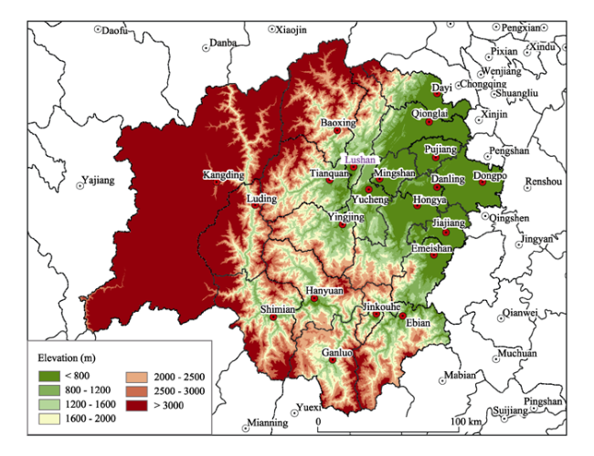
Figure 1 Study area, Lushan, Sichuan Province, China

2.2 Data collection

The data of seismic belt and active fault, secondary geological hazards, engineering geology and hydrological geology are collected from China Earthquake Administration and Sichuan Earthquake Administration. The data of topography and land use are obtained from Land and Resources Department and Surveying, Mapping and Geo-information Bureau of Sichuan Province. The data of water resources, ecology, and environment are acquired from Water Resources Department, Forestry Department, and Environmental Protection Department of Sichuan Province. The scale of Digital Elevation Mapping (DEM) is 1:50,000. The land suitability assessment units for reconstruction were divided into 30 m × 30 m raster grid cells by using GIS 10.1 software. Each cell was considered as a homogeneous unit for any given factor. In addition, the demographic and economic data are derived from statistical yearbooks of Sichuan Province.

2.3 Establishing assessment factors system

Because construction land suitability level is a result of the interactions of each assessment factor, appropriate selection of assessment factors is critical to ensure meaningful suitability assessment results for construction land (Joerin et al., 2001). In order to integrate the construction land characteristics of the stricken area and the special requirements for reconstruction, three factor groups including geological conditions and disaster risk, water and land resources condition, and ecological and environmental indices, are determined for the land suitability assessment for reconstruction of the Lushan earthquake. Then eight separate and sensitive factors were selected via AHP: seismic risk, engineering geology, hydrological geology, susceptibility of secondary geological hazards, topographic condition, water resources condition, ecological function, and environmental capacity.
According to the relationship between geological and environmental factors and land use for reconstruction, each factor was graded by analyzing its influence on land suitability for reconstruction. The land suitability for reconstruction was first classified into five levels: levels I, II, III, IV, and V. These five levels were assigned scores of 5, 4, 3, 2, and 1, respectively. The graded score has a positive correlation with the land suitability for reconstruction. In other words, the greater score implies the higher land suitability for reconstruction. The classification description and standardized scoring for each factor are shown in Table 1. The different statistical and empirical references from the related disciplinary rules and the literature were employed in determining the boundary scores of the land suitability assessment for reconstruction.
Table 1 The classification description and standardized scoring of each factor for land suitability assessment for post-earthquake reconstruction
No. Standardized scoring 5 4 3 2 1
1 Seismic risk No risk - Low Middle High
2 Engineering geology Hard rock, located in plain region (Chengdu Plain) Relatively hard rock, mesa at low elevation Relatively soft rock, hilly area in low elevation Soft rock, hilly area at middle
elevation
Extremely soft rock, mountain at high elevation
3 Hydrological geology Pore water, fresh groundwater Karstic water, fresh water above and saline water under Karstic water, saline water above and fresh water under Fissure water,
slightly saline
water
Aquiclude, saline water
4 Susceptibility of secondary geological hazards No hazards - Low Middle High
5 Topographic condition <5° 5°-8° 8°-15° 15°-25° > 25°
6 Water resources condition (m3/person) >3000 1500-3000 1000-1500 500-1000 < 500
7 Ecological function Not important - Relatively important Important Extreme important
8 Environmental capacity No overloading Slight overloading Moderate overloading Serious overloading Extreme overloading
The weights of three factor groups and eight factors were determined according to their relative importance ranking with AHP. Besides, a survey of factor weight indicating the influence of geological and environmental factors on land suitability for reconstruction was carried out by 50 experts who are specialized in the fields of geology, geography, eco-environment, land use, and regional planning. The average weight of each factor calculated from the survey and the ranking of AHP were integrated to determine the final weight of each factor (Table 2).
Table 2 The weights of factor groups and factors for land suitability assessment for post-earthquake reconstruction
Factor groups Weight (%) Assessment factors Weight (%) Percentage (%)
Geological conditions and disaster risk 45 Seismic risk 30 13.5
Engineering geology 20 9
Hydrological geology 20 9
Susceptibility of secondary geological hazards 30 13.5
Water and land resources condition 30 Topographic condition 60 18
Water resources condition 40 12
Ecological and environmental indices 25 Ecological function 60 18
Environmental capacity 40 12
Total 100 - - 100

2.4 Arithmetical formulae

With the key factors identified, a metric for land suitability for reconstruction now can be formulated. The approach adopted for this study is that the complex interaction between factor groups and factors are summarized by the different weights and scores assigned. The accumulated results will indicate the land suitability level for reconstruction of each 30 × 30 m2 grid considering the comprehensive influence of all factors. Based on this, the arithmetical formulae can be defined as follows:
where S is the accumulated score of land suitability for reconstruction, Si is the score of certain factor group, Pj is the score of factor j out of factor group i, Wj is the weight of factor j, Wj is the weight of factor group i, m is the number of factors in certain factor group, and n is the number of factor groups.
In this study three factor groups including geological conditions and disaster risk, water and land resources condition, and ecological and environmental indices were picked out for land suitability assessment, so n=3. For the first factor group of geological conditions and disaster risk, four factors including seismic risk, engineering geology, hydrological geology and susceptibility of secondary geological hazards were selected, so m1= 4. For the second factor group of water and land resources condition, two factors including topographic condition and water resources condition were chosen, so m2=2. For the third factor group of ecological and environmental indices, two factors including ecological function, and environmental capacity were selected, so m3=2. The total m is equal to 8.

3 Results and analysis

3.1 Results at grid scale

The results at grid scale are shown in Figure 2. The area of suitable land for post-earthquake reconstruction is 8422.29 km2, accounting for 19.69% of the total land area of 21 counties (Table 3). The area of High Class land suitability for reconstruction is 2409.30 km2, accounting for 28.61% of the total suitable land and 5.63% of the total land area. This class has good geological conditions, mainly associated with the Chengdu Plain region where slope is usually below 5°. This region is far away from seismic fault, with very low susceptibility of secondary geological hazards. The ecosystem services function is not important, with no biodiversity conservation zone located. The High Class is mainly distributed in the piedmont plains, including Dayi, Qionglai, Pujiang, Dongpo, Danling, Mingshan, Yucheng, Hongya, Jiajiang, and Emeishan. All these counties are located in the southeastern part of the stricken area. This class should be recognized as the first choice for post-earthquake reconstruction, as it is most suitable for construction of new towns and buildings.
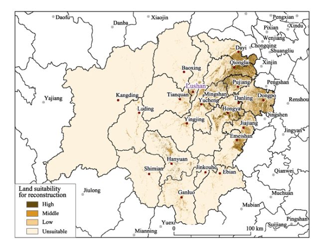
Figure 2 Land suitability for post-earthquake reconstruction at grid scale in the stricken area of Sichuan Province
Table 3 Data of different classes of land suitability for post-earthquake reconstruction in the stricken area of Sichuan Province
Land suitability class Area (km2) Percentage in total
suitable land (%)
Percentage in total land area of 21 counties (%)
High 2409.30 28.61 5.63
Middle 1992.22 23.65 4.66
Low 4020.77 47.74 9.40
Total suitable land 8422.29 100 19.69
Unsuitable 34360.90 - 80.31
The area of Middle Class land suitability for reconstruction is 1992.22 km2, accounting for 23.65% of the total suitable land and 4.66% of the total land area. This class has fair geological conditions, mainly associated with the hilly area at middle elevation (1000-2000 m) where slope is between 5°-8°. This region has low probability of occurrence of secondary geological hazards, and the ecosystem services function is relatively low. The spatial distribution of Middle Class is similar to the High Class, and most of the Middle Class regions are adjacent to the High Class region. The Middle Class should be regarded as the supplementary region of the High Class for the post-earthquake reconstruction.
The area of Low Class land suitability for reconstruction is 4020.77 km2, accounting for 47.74% of the total suitable land and 9.40% of the total land area. This class has poor geological conditions, mainly associated with the hilly area at intermediate to high elevation (2000-3000 m) where slope is between 8°-15°. This region has middle probability of occurrence of secondary geological hazards, and the ecosystem services function is relatively important. The Low Class is usually scattered between mountains and valleys. Considering the constraints in geology, topography, and eco-environment, the site selection of new city and urban construction need to be very cautious in the Low Class region.
The area of Unsuitable Class is 34,360.90 km2, accounting for 80.31% of the total land area. This class has terrible geological conditions, mainly associated with the mountain area at high elevation above 3000m) where slope is above 15°. This region has high probability of occurrence of secondary geological hazards, and the ecosystem services function is important. The Unsuitable Class region should not be selected for post-earthquake reconstruction.

3.2 Land suitability assessment at administrative scale

The land suitability results at county level are analyzed by summarizing all the cells of High, Middle, and Low classes of villages and towns in each county, respectively. The hard-hit counties including Lushan, Yucheng, Tianquan, Mingshan, Yingjing, and Baoxing are summarized by villages, and the other counties by towns. The construction index is defined as the ratio of total suitable land to the total land area of each county. The construction index values of 11 counties including Lushan, Baoxing, Yingjing, Tianquan, Jinkouhe, Ebian, Hanyuan, Shimian, Kangding, Luding, and Ganluo are below 20%, most of which are situated at the western mountainous region (Table 4). The total land area of these 11 counties amounts to 32251.46 km2, accounting for 75.40% of the stricken area. The construction index values of six counties including Mingshan, Pujiang, Qionglai, Dongpo, Jiajiang, and Danling are above 60%, all of which are located at the eastern piedmont plain. The total suitable land area of these six counties amounts to 3812.35 km2, accounting for 45.19% of the total suitable land of the stricken area. Out of those counties with serious damage, only Mingshan has high construction index (75.73%), and the suitable land area is 468.33 km2. It should be regarded as preferred region for the rebuilding of the hard-hit areas.
The High and Middle classes are mainly concentrated in the eastern piedmont plain, including most towns of Dongpo, Dayi, Qionglai, Pujiang, Jiajiang, Danling, and Hongya(at town scale) and most villages of Mingshan and several villages of Yucheng (at village scale) (Figure 3). The Low and Unsuitable classes are mainly distributed in western mountainous region and central hilly area. Most towns of Kangding, Luding, and Shimian belong to the Unsuitable Class, with the construction index below 10%. Most villages in the northern part of Lushan belong to Low and Unsuitable classes, while the county seat of Lushan including towns of Luyang, Chengbei, and Chengnan belong to the Middle Class. In addition, Caoping village lying to the west of Luyang belongs to the High Class, and it can be selected for post-earthquake reconstruction in Lushan. Except 3 villages including Lingguan, Shangba, and Zhongba, most regions in Baoxing belong to the Low and Unsuitable classes. The land suitability in Baoxing is very low. Most regions in Mingshan belong to the High and Middle classes, and they can be used for post-earthquake population agglomeration and urban development due to excellent land suitability for reconstruction.
Table 4 Data of different classes of land suitability for post-earthquake reconstruction at county level in the stricken area of Sichuan province
County Total land area (km2) Total suitable land (km2) High Class Middle Class Low Class Construction index2 (%)
Area (km2) Proportion (%)1 Area (km2) Proportion (%)1 Area (km2) Proportion (%)1
Lushan 1191.42 202.19 31.84 15.75 39.37 19.47 130.98 64.78 16.97
Yucheng 1062.79 440.92 93.86 21.29 90.67 20.56 256.40 58.15 41.49
Tianquan 2390.48 312.50 44.37 14.20 59.11 18.91 209.02 66.89 13.07
Mingshan 618.39 468.33 190.61 40.70 117.55 25.10 160.16 34.20 75.73
Yingjing 1776.89 353.04 48.79 13.82 63.92 18.10 240.33 68.08 19.87
Baoxing 3114.35 124.72 14.18 11.37 20.29 16.27 90.25 72.36 4.00
Qionglai 1377.07 911.57 371.51 40.76 233.31 25.59 306.74 33.65 66.20
Hanyuan 2214.89 347.01 48.84 14.07 64.58 18.61 233.59 67.32 15.67
Pujiang 580.42 490.43 217.92 44.43 133.74 27.27 138.77 28.30 84.50
Danling 449.48 329.62 105.49 32.00 88.40 26.82 135.74 41.18 73.33
Hongya 1898.19 770.86 218.60 28.36 176.10 22.84 376.16 48.80 40.61
Jinkouhe 598.32 70.83 9.56 13.50 12.99 18.34 48.28 68.17 11.84
Dayi 1282.97 556.49 203.79 36.62 145.50 26.15 207.19 37.23 43.37
Shimian 2678.08 154.95 19.43 12.54 27.54 17.77 107.99 69.69 5.79
Luding 2164.53 89.09 15.39 17.27 19.27 21.63 54.43 61.10 4.12
Jiajiang 743.44 506.45 161.05 31.80 132.56 26.17 212.84 42.03 68.12
Emeishan 1181.47 520.48 140.50 26.99 123.42 23.71 256.55 49.29 44.05
Ganluo 2151.89 276.31 29.78 10.78 47.78 17.29 198.75 71.93 12.84
Dongpo 1336.06 1105.94 395.02 35.72 324.68 29.36 386.23 34.92 82.78
Ebian 2381.90 355.23 42.81 12.05 64.22 18.08 248.19 69.87 14.91
Kangding 11590.16 35.34 5.98 16.93 7.22 20.43 22.14 62.64 0.30
Total 42783.20 8422.29 2409.30 28.61 1992.22 23.65 4020.77 47.74 19.69

1 Refer to the proportion in total suitable land. 2 Refer to the ratio of total suitable land to the total land area.

3.3 Suitable land per capita for reconstruction

The result of suitable land per capita for reconstruction is analyzed at county level. The total suitable land area of each county is summarized by villages and towns. The spatial characteristics of total suitable land area of counties are similar to that at grid scale (Figure 4). All the counties with rich suitable land are concentrated in the piedmont plains which lie in the northeast of the stricken area. Three counties including Dongpo, Qionglai, and Hongya have the total suitable land area above 60,000 hm2, and six counties including Dayi, Emeishan, Jiajiang, Pujiang, Mingshan, and Yucheng have the total suitable land area between 40,000 and 60,000 hm2. Only Mingshan and Yucheng belong to hard-hit area among these ten counties. The total suitable land area of Lushan is only 20,218.74 hm2.
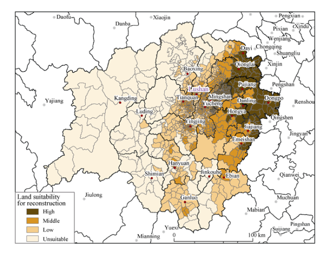
Figure 3 Land suitability for post-earthquake reconstruction at administrative scale in the stricken area in Sichuan Province (six hard-hit counties by village, and other 15 counties by towns)
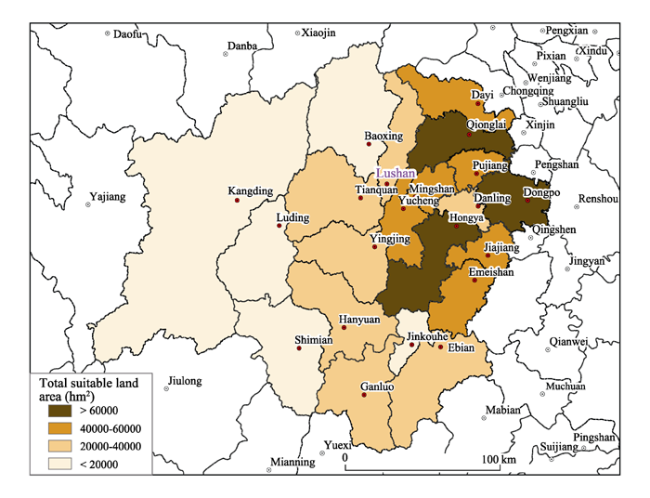
Figure 4 Total suitable land area of 21 counties in the stricken area in Sichuan Province
Divided by the resident population, the suitable land per capita is obtained. It could be considered to be a supplementary indicator for post-earthquake reconstruction. The spatial characteristics of suitable land per capita are not the same to that of total suitable land due to the counties with different population sizes (Figure 5). Several counties with low suitable land area still have relatively high suitable land per capita due to their low population size, Baoxing for instance. Five counties including Hongya, Ebian, Yingjing, Tianquan, and Danling have the suitable land per capita above 0.23 hm2/person, and four counties including Baoxing, Pujiang, Lushan, and Mingshan have the suitable land per capita between 0.18-0.23 hm2/person. Considering the total suitable land area and suitable land per capita, Mingshan is the preferred county for post-earthquake reconstruction in the hard-hit area.
Figure 5 Suitable land area per capita of 21 counties in the stricken area in Sichuan Province

4 Discussion

4.1 The role of land suitability assessment in reconstruction planning

The land suitability assessment is one of the fundamental tasks in the development of post-earthquake reconstruction planning. By integrating geological conditions, risk of disasters, water and land resources conditions, and eco-environmental suitability, the land suitability assessment delineates the spatial characteristics of the 21 stricken counties for post-earthquake reconstruction. The land suitability results have strong link to the site selection of post-earthquake reconstruction region and new buildings, because the location of preferred area for reconstruction can be spatially identified through land suitability assessment. It reveals the spatial pattern of land suitability for reconstruction of 21 counties in the stricken area. For a specific county, it is able to reveal the spatial pattern of land suitability for reconstruction of different towns and villages.
According to the land suitability results, most of the mountainous regions in the west of the stricken area are not suitable for reconstruction due to high elevation, steep slope, and scarce land resources. Several valleys of the central hilly area are suitable for small-scale population aggregation, industrialization, and urbanization development. Because of low elevation, flat topography, and good geological conditions, most of the piedmont plains in the east are suitable for large-scale population aggregation, industrialization, and urbanization development. Actually, this spatial pattern of land suitability provided important scientific information for planners to make sound reconstruction planning for achieving sustainable regional development of the stricken area.

4.2 Future considerations

Different with previous work on land suitability assessment (Dai et al., 2001; Fan et al., 2011; Xu and Zhang, 2013), this study focuses on the land suitability for post-earthquake reconstruction and develops an assessment method by integrating geological conditions, risk of disasters, water and land resources conditions, and eco-environmental suitability. The safety factor is emphasized to assess land suitability at different study scales and the geological conditions and disaster risk take relatively high weight. This effort is innovative in the field of land suitability assessment because it introduces an assessment method for land suitability for post-earthquake reconstruction.
Nevertheless, it is very difficult to delineate all the contents of land suitability by a single index such as construction index or suitability land per capita due to its complexity and multiple involved factors. Therefore, some issues could be further considered when applying the indicator for practical purposes. First, the integration of geological conditions, risk of disasters, water and land resources conditions, and eco-environmental suitability is complicated because multi-disciplinary knowledge and experiences are necessary for the land suitability assessment. Second, social and economic factors such as the affordability of government and residents, current level of economic development, the state of infrastructure, and regional preferential policies are related to the implementation of reconstruction planning. These factors would influence the role that land suitability assessment plays in the practical reconstruction.

5 Conclusions

In this study, a methodology for land suitability assessment for post-earthquake reconstruction was developed and applied to the case study of Lushan, China. Conclusions of the research are summarized as follows:
(1) The spatial characteristics of land suitability for reconstruction at grid scale manifest that the classes of High, Middle, and Low suitability amount to 8422.29 km2, accounting for only 19.69% of the total land area; while Unsuitable area is 34,360.90 km2, accounting for 80.31%. The class of High suitability covers 2409.30 km2, accounting for 5.63% of the total land area, most of which are located on the piedmont plains in the east. This kind of region should be regarded as the preferred region for reconstruction, which is suitable for large-scale population aggregation, industrialization, and urbanization development. The class of Middle suitability could be used as supplemental choice for the class of High suitability, and the class of Low suitability should be considered for reconstruction with much carefulness and sufficient preventive measures.
(2) The land suitability for reconstruction at administrative scale show that 11 out of 21 counties in the stricken area have low construction index (below 0.20), most of which are located in the mountainous regions in the west; while only 6 counties have relative high construction index (above 0.60), all of which are located on the piedmont plains in the east. For the 6 hard-hit counties, only Mingshan has high construction index (0.76), with the total suitable land of 468.33 km2. It should be selected as the preferred region for large-scale population aggregation, urban construction, and industrial development in the hard-hit regions. Some plots of land in the valleys could be selected for in-situ small-scale reconstruction in Lushan.
(3) Land suitability assessment for post-earthquake reconstruction proves to be a valuable effort to reveal the land suitability of different regions for industrial and urban reconstruction in the stricken area. It is innovative in integrating geological conditions, risk of disasters, water and land resources conditions, and eco-environmental suitability and emphasizing safety factor in the assessment. The assessment of land suitability depicts a clear picture of land capacity of different regions for reconstruction. The land suitability assessment plays an important role in making sound reconstruction planning for achieving sustainable regional development in the Mw 6.6 Lushan earthquake stricken area. This study could be used for reference to the regions with similar events both here in China and elsewhere.

The authors have declared that no competing interests exist.

1
Alparslan A, Ince F, Erkan Bet al., 2008. A GIS model for settlement suitability regarding disaster mitigation, a case study in Bolu Turkey.Engineering Geology, 96: 126-140.

2
Bagdanaviciute I, Valiunas J, 2013. GIS-based land suitability analysis integrating multi-criteria evaluation for the allocation of potential pollution sources.Environmental Earth Sciences, 68(6): 1797-1812.

3
Cross M, 2002. Landslide susceptibility maps using the matrix assessment approach: A Derbyshire case study. In: Griffiths JS (ed.). Mapping in Engineering Geology, The Geological Society London, Key Issues in Earth Sciences, 1: 267-282.

4
Dai F C, Lee C F, Zhang X H, 2001. GIS based geo-environmental evaluation for urban land-use planning: A case study.Engineering Geology, 61: 257-271.

5
Dang Lijuan, Xu Yong, Tang Qinget al., 2015. The pattern of available construction land along the Xijiang River in Guangxi, China.Land Use Policy, 42: 102-112.

6
Davidson D A, Theocharopoulos S P, Bloksma R J, 1994. A land evaluation project in Greece using GIS and based on Boolean and fuzzy set methodologies.International Journal of Geographical Information Systems, 8(4): 369-384.

7
Du Fang, Long Feng, Ruan Xianget al., 2013. The M7.0 Lushan earthquake and the relationship with the M8.0 Wenchuan earthquake in Sichuan, China.Chinese Journal of Geophysics, 56(5): 1772-1783. (in Chinese)

8
Dunford M, Li Li, 2011. Earthquake reconstruction in Wenchuan: Assessing the state overall plan and addressing the ‘forgotten phase’.Applied Geography, 31: 998-1009.

9
Fan Chenjing, Shen Shiguang, Wang Sihuiet al., 2011. Research on urban land ecological suitability evaluation based on gravity-resistance model: A case study of Deyang city in China.Procedia Engineering, 21: 676-685.

10
Fang Chuanglin, Wu Fenglin, Li Maoxun, 2011. Suitability evaluation of population and settlements spatial layout after Wenchuan Earthquake.Journal of Geographical Sciences, 21(3): 539-548.

11
Fang Lihua, Wu Jianping, Wang Weilaiet al., 2013. Relocation of mainshock and aftershock sequences of Ms7.0 Sichuan Lushan earthquake.Chinese Science Bulletin, 58(28/29): 3451-3459.

12
Gong Jianzhou, Liu Yansui, Chen Wenli, 2012. Land suitability evaluation for development using a matter-element model: A case study in Zengcheng, Guangzhou, China.Land Use Policy, 29: 464-472.

13
Hall G B, Wang F, Subaryono J, 1992. Comparison of Boolean and fuzzy classification methods in land suitability analysis by using geographical information systems.Environment and Planning A, 24: 497-516.

14
Joerin F, Theriault M, Musy A, 2001. Using GIS and outranking multicriteria analysis for landuse suitability assessment.International Journal of Geographical Information Science, 15: 151-174.

15
Lathrop R G, Bognar J J A, 1998. Applying GIS and landscape ecological principles to evaluate land conservation alternatives.Landscape and Urban Planning, 41: 27-41.

16
Lee S, Ryu J H, Won J Set al., 2004. Determination and application of the weights for landslide susceptibility mapping using an artificial neural network.Engineering Geology, 71: 289-302.

17
Li Yiquan, Jia Dong, Wang Maomaoet al., 2014. Structural geometry of the source region for the 2013 Mw 6.6 Lushan earthquake: Implication for earthquake hazard assessment along the Longmen Shan.Earth and Planetary Science Letters, 390: 275-286.

18
Liu Bintao, Liu Shaoquan, Tao Heping, et al. 2011. Land resources assessment model for mountainous areas based on GIS: A case study of Liangshan Yizu autonomous prefecture, Sichuan Province.Acta Geographica Sinica, 66(8): 1131-1140. (in Chinese)

19
Liu Yansui, Wang Jieyong, Guo Liying, 2006. GIS-based assessment of land suitability for optimal allocation in the Qinling Mountains, China.Pedosphere, 16(5): 579-586.

20
Liu Yansui, Wang Lijuan, Long Hualou, 2008. Spatio-temporal analysis of land-use conversion in the eastern coastal China during 1996-2005.Journal of Geographical Sciences, 18(3): 274-282.

21
Matula M, 1981. Rock and soil description and classification for engineering geological mapping report by the IAEG Commission on Engineering Geological Mapping.Bulletin of Engineering Geology and the Environment, 24(1): 235-274.

22
Miller H J, Han J, 2009. Geographic Data Mining and Knowledge Discovery. 2nd ed. Boca Raton, FL, USA: Chapman & Hall/CRC Press Inc.

23
NisarAhamed T R, Gopal Rao K, Murthy J S R, 2000. GIS-based fuzzy membership model for crop-land suitability analysis.Agricultural Systems, 63: 75-95.

24
Nuissl H, Haase D, Lanzendorf Met al., 2009. Environmental impact assessment of urban land use transitions: A context-sensitive approach.Land Use Policy, 26: 414-424.

25
Reshmidevi T V, Eldho T I, Jana R, 2009. A GIS-integrated fuzzy rule-based inference system for land suitability evaluation in agricultural watersheds.Agricultural Systems, 101: 101-109.

26
Sarkar B C, Mahanta B N, Saikia Ket al., 2007. Geo-environmental quality assessment in Jharia coalfield, India, using multivariate statistics and geographic information system.Environmental Geology, 51: 1177-1196.

27
Shi Zheming, Wang Guangcai, Wang Chiyuenet al., 2014. Comparison of hydrological responses to the Wenchuan and Lushan earthquakes.Earth and Planetary Science Letters, 391: 193-200.

28
Store R, Kangas J, 2001. Integrating spatial multi-criteria evaluation and expert knowledge for GIS-based habitat suitability modeling.Landscape and Urban Planning, 55(2): 79-93.

29
Svoray T, Bar P, Bannet T, 2005. Urban land-use allocation in a Mediterranean ecotone: Habitat heterogeneity model incorporated in a GIS using a multi-criteria mechanism.Landscape and Urban Planning, 72: 337-351.

30
Tseng M H, Chen S J, Hwang G Het al., 2008. A genetic algorithm rule-based approach for land-cover classification.ISPRS Journal of Photogrammetry and Remote Sensing, 63(2): 202-212.

31
U.S.Geological Survey (USGS), 2008. National Earthquake Information Center. last accessed 20th April 2013.

32
Van Broekhoven E, Adriaenssens V, De Baets Bet al., 2006. Fuzzy rule-based macroinvertebrate habitat suitability models for running waters.Ecological Modeling, 198: 71-84.

33
Xu Erqi, Zhang Hongqi, 2013. Spatially-explicit sensitivity analysis for land suitability evaluation.Applied Geography, 45: 1-9.

34
Xu Kai, Kong Chunfang, Li Jiangfenget al., 2011. Suitability evaluation of urban construction land based on geo-environmental factors of Hangzhou, China. Computers & Geosciences, 37: 992-1002.

35
Xu Yong, Tang Qing, Fan Jieet al., 2010.Available land index items and their calculational methods for Major Function Oriented Regionalization.Geographical Research, 29(7): 1223-1232. (in Chinese)

36
Xu Yong, Tang Qing, Fan Jieet al., 2011. Assessing construction land potential and its spatial pattern in China.Landscape and Urban Planning, 103: 207-216.

37
Yu Jia, Chen Yun, Wu Jianping, 2011. Modeling and implementation of classification rule discovery by ant colony optimisation for spatial land-use suitability assessment.Computers, Environment and Urban Systems, 35: 308-319.

38
Zheng Rongbao, Liu Yihua, Dong Yuxianget al., 2009. Appraisal of land resources security in Guangzhou based on major function regionalization.Acta Geographica Sinica, 64(6): 654-664. (in Chinese)

39
Zhu X, Aspinall R J, Healey R G, 1996. ILUDSS: A knowledge-based spatial decision support system for strategic land-use planning.Computers and Electronics in Agriculture, 15(3): 279-301.

Outlines

/