
Journal of Geographical Sciences >
Spatio-temporal characteristics of rural settlements and land use in the Bohai Rim of China
*Corresponding author: Liu Yansui (1965-), Professor, specialized in land science and agriculture and rural development. E-mail:liuys@igsnrr.ac.cn
Author: Yang Ren (1984-), PhD and Lecturer, specialized in rural reconstruction, rural-urban transformation and land use optimal allocation. E-mail:yangren0514@163.com
Received date: 2014-07-05
Accepted date: 2014-12-30
Online published: 2015-05-15
Supported by
National Natural Science Foundation of China, No.41401190;No.41130748;No.41101165
Copyright
Based on multiple remote-sensing image interpretation and classification, and economic and social data, this study focused on rural settlement and land use change amidst rapid urbanization. Rural settlements, spatial and temporal patterns of land use and influencing factors in the Bohai Rim were explored within 5×5 km grid cells, as per GIS spatial analysis and geostatistical analysis. Results show that the spatial distribution of rural settlements in the Bohai Rim is remarkably varied. The number of rural settlement sites in a 5×5 km grid cell exceeding 5.0 are distributed in a six-area pattern in the Bohai Rim; rural settlement dispersion is particularly high in agricultural regions in south Hebei and southwest Shandong, suggesting rural settlement density keeps increasing from northeast to southwest, characterized by high density and dispersed spatial distribution in traditional agricultural regions. Furthermore, rural settlements show dramatic spatial differences in terms of distribution and dynamic change degrees in the Bohai Rim. In terms of spatial distribution, rural residential land is always extensive in plains, with a high density of rural settlements, on the North China Plain in particular, and rural residential land in the south of Shandong province is also extensive, with most rural settlement land use areas in the 5×5 km grid cells exceeding 3 km2. However, traditional agricultural regions have underdeveloped economies, industrialization and tertiary industries, characterized by low urbanization rates, with farmers not feeling assimilated in rural or urban areas. In terms of the temporal sequence, urban expansion rapidly promotes the transformation of rural residential lands in rural-urban transitional belts of provincial capital or prefecture-level city into urban lands, and in traditional rural areas, residential lands are growing. The natural environment, transportation conditions, economic development and farmers’ incomes all have effects on type of land use change and pattern of rural settlements. It is a core objective for future rural development to reconstruct a rational spatial pattern of villages or towns and well-organized village-town systems, build central villages, key towns or central towns, optimize or reconstruct production, living and eco-space of rural areas. It is of significance for rural geographical research to further interpret and explore spatial reconstruction theory.
Key words: rural residential lands; influence mechanism; rural geography; Bohai Rim; China
YANG Ren , LIU Yansui , LONG Hualou , QIAO Luyin . Spatio-temporal characteristics of rural settlements and land use in the Bohai Rim of China[J]. Journal of Geographical Sciences, 2015 , 25(5) : 559 -572 . DOI: 10.1007/s11442-015-1187-6
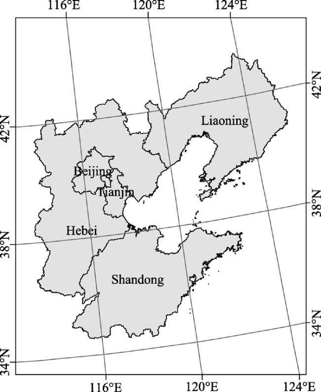
Figure 1 The location of the study area (Bohai Rim of China) |
 represents variance of dynamic degrees of residential land changes and
  represents the variance of secondary regions. Formally,
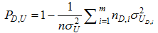
  , and the range of PD,U is [0, 1], when PD,U = 0, it is suggested that dynamic degree of residential lands at county level is randomly distributed and the higher the PD,U value, the higher the influence of partitioning on the dynamic degree. In the research, a total of 13 indices were chosen, comprising: yield of a crop per unit area, total power of agricultural machinery, grain yield per labor force, irrigation rate, agricultural area per capita, labor force per unit of farmland, transportation, non-agricultural employment rate in rural areas, distance to downtown, terrain, primary industry, net income per capita and GDP per capita, with area partitioned, in order to make a quantitative detection of the relevant effects on changes of rural residential lands at county level.
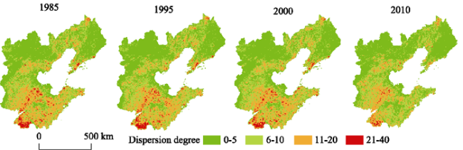
Figure 2 The spatial distribution of rural settlement site dispersion degree in 5 × 5 km cells in 1985, 1995, 2000 and 2010 in the Bohai Rim of China |
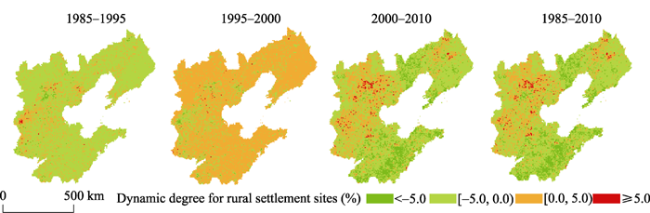
Figure 3 The spatial distribution of dynamic degree for rural settlement sites in a 5 × 5 km grid cell from 1985 to 2010 in the Bohai Rim of China |
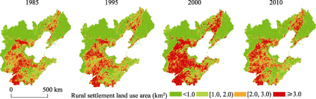
Figure 4 The spatial distribution of rural settlements land use area in a 5 × 5 km grid cell in 1985, 1995, 2000 and 2010 in the Bohai Rim of China |
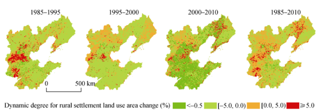
Figure 5 The spatial distribution of dynamic degree for rural settlement land use area in a 5 × 5 km cell from 1985 to 2010 in the Bohai Rim of China |
Table 1 The geographic detected power of influencing factors for the rural residential land change |
| Indices/ | f1 | f2 | f3 | f4 | f5 | f6 | f7 | f8 | f9 | f10 | f11 | f12 | f13 |
|---|---|---|---|---|---|---|---|---|---|---|---|---|---|
| Threshold value | (hm2/ per) | (per/ hm2) | (103kg/ hm2) | (%) | (kw/ hm2) | (103kg/ per) | (103 yuan) | (%) | (103 yuan) | (km) | (km) | (m) | (%) |
| First zone | <0.1 | <20 | <4.5 | <40 | <1.0 | <2.0 | <15 | <15 | <4.5 | <15 | <90 | <500 | <-10 |
| Second zone | 0.1-0.2 | 20-30 | 4.5-8.0 | 40-75 | 1.0-1.5 | 2.0-3.0 | 15-30 | 15-30 | 4.5-7.5 | 15-30 | 90-150 | 500-100 | -10 to -5 |
| Third zone | >0.2 | >30 | >8.0 | >75 | >1.5 | >3.0 | >30 | >30 | >7.5 | >30 | >150 | >1000 | >-5 |
| P-value | 0.42 | 0.35 | 0.32 | 0.21 | 0.33 | 0.38 | 0.82 | 0.27 | 0.81 | 0.58 | 0.72 | 0.66 | 0.42 |
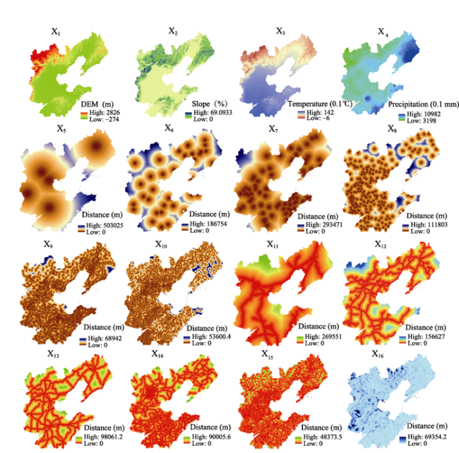
Table 2 Influencing factors on rural settlements and spatial distribution of land use |
| Natural conditions | Point (centrality) | Axis (traffic lines and rivers) |
|---|---|---|
| Dem (x1) Slope (x2) Temperature (x3) Precipitation (x4) | Distance to provincial capital (x5) Distances to prefecture-level city (x6) Distances to county-level city (x7) Distance to counties (x8) Distance to towns (x9) Distance to villages (x10) | Distance to railway (x11) Distance to expressway (x12) Distance to national road (x13) Distance to provincial road ( x14) Distance to county or village roads (x15) Distance to rivers (x16) |
Figure 6 Factors influencing rural settlements and spatial distribution of land use |
The authors have declared that no competing interests exist.
| 1 |
|
| 2 |
|
| 3 |
|
| 4 |
|
| 5 |
|
| 6 |
|
| 7 |
|
| 8 |
|
| 9 |
|
| 10 |
|
| 11 |
|
| 12 |
|
| 13 |
|
| 14 |
|
| 15 |
|
| 16 |
|
| 17 |
|
| 18 |
|
| 19 |
|
| 20 |
|
| 21 |
|
| 22 |
|
| 23 |
|
| 24 |
|
| 25 |
|
| 26 |
|
| 27 |
|
| 28 |
|
/
| 〈 |
|
〉 |