Research Articles

Problem regions and regional problems of socio- economic development in China: A perspective from the coordinated development of industrialization, informatization, urbanization and agricultural modernization

  • LI Yurui , 1, 2 ,
  • WANG Jing 3 ,
  • LIU Yansui 1, 2 ,
  • LONG Hualou 1, 2
Expand
  • 1. Institute of Geographic Sciences and Natural Resources Research, CAS, Beijing 100101, China
  • 2. Key Laboratory of Regional Sustainable Development Modeling, CAS, Beijing 100101, China
  • 3. Beijing Academy of Social Sciences, Beijing 100101, China

Author: Li Yurui (1983-), PhD and Assistant Professor, specialized in land science and agriculture and rural development. E-mail:

Received date: 2014-06-01

  Accepted date: 2014-08-01

  Online published: 2014-06-20

Supported by

National Natural Science Foundation of China, No.41201176.No.41171149.No.41130748

Copyright

Journal of Geographical Sciences, All Rights Reserved

Abstract

Identifying the problem regions and regional problems, and thus improving regional policies, are crucial for the sustainable development of various economic entities. The coordinated development of industrialization, informatization, urbanization and agricultural modernization (hereinafter referred to as “Sihua”) is not only a practical need but an important strategic direction of integrating urban-rural development and regional development in recent China, and it also provides a significant perspective for identifying problem regions and regional problems so as to improve the regional policies. This study mainly aims to: firstly, establish a comprehensive evaluation index system so as to explore the spatial pattern of coordinated development of Sihua in China at prefecture level; secondly, to develop an evaluation criteria system to identify the problem regions and regional problems from the perspective of coordinated development of Sihua. This paper comes first in the scientific community to evaluate the coordinated development state of Sihua in China at prefecture level and identify the problem regions and regional problems from the perspective of Sihua development by quantitative analysis. This study may benefit the improvement of regional policies and thus contribute to the sustainable socio-economic development of China.

Cite this article

LI Yurui , WANG Jing , LIU Yansui , LONG Hualou . Problem regions and regional problems of socio- economic development in China: A perspective from the coordinated development of industrialization, informatization, urbanization and agricultural modernization[J]. Journal of Geographical Sciences, 2014 , 24(6) : 1115 -1130 . DOI: 10.1007/s11442-014-1142-y

1 Introduction

China’s socio-economic development has made great progress since the implementation of reform and opening up policy. However, China is still confronted with low-level industrialization, urbanization and agricultural modernization development, and serious resource and environment problems. In addition, it is widely accepted that current macro socio-economic policies lead to severe regional disparities (Ying, 2003; Wei and Ye, 2009; Li and Wei, 2010; Long et al., 2011). Many regions show high quality of sustainable development while there are also regions lagging far behind and struggling for the central government’s special assistance (Liu, 2007; Liu et al., 2009). Therefore, it is urgent to improve the efficiency and quality of socio-economic development by changing economic growth mode and innovating development policies (Fan and Li, 2009; Fan et al., 2010; Long, 2014; Long et al., 2010).
A better understanding of problem regions and regional problems is an important premise for designing and improving regional policies (Damesick and Wood, 1987; Zhang and Hu, 2004). Presently, the regional patterns of gross domestic production (GDP) per capita (Li and Qiao, 2001), income disparities of rural population and urban residents (Liu, 2006; Tang et al., 2006; Liu et al., 2011), sustainability of natural environment (Yang and Ma, 2009), efficiency of urban land use (Wu et al., 2011) and water resource’s supporting capacity of regional socio-economic development (Li and Li, 2012) have been discussed a lot and have deepened our scientific understanding of China’s regional development and spatial differences. However, little research has been conducted on identifying problem regions and discussing the regional problems, which can directly provide scientific guidelines for the designing of regional policies and thus contributing a lot to the sustainable socio-economic development of corresponding regions even the whole country (Zhang and Hu, 2004; Peng, 2008; Liu et al., 2009).
In 2012, the report of the 18th CPC National Congress pushed for an important strategic requirement and historic task of “The promotion of integrating informatization and industrialization, the positive interaction of industrialization and urbanization, and the coordination of urbanization and agricultural modernization to boost the synchronous development of industrialization, informatization, urbanization and agricultural modernization” (so called “Sihua tongbu” in Chinese), which acted as the new guidance for the regional development in the new era. By systematically analyzing the development state, coordinated features and the main influencing factors of industrialization, informatization, urbanization and agricultural modernization (“Sihua” hereafter), we may come up with new scientific cognition for China’s regional development. So far, various studies on Sihua have been carried out at both national and provincial levels (Chen et al., 2006; Gu et al., 2008; Xie et al., 2012; Fang et al., 2008; Chen et al., 2009; Jiang et al., 2006). The conventional starting point is either to evaluate the state of Sihua using a single indicator or index system, or to explore the causal interaction between Sihua by time series analysis method, and to analyze the synchronization of Sihua by various coordination models (Ding et al., 2013; Xu et al., 2012; Qian et al., 2012; Xie et al., 2012; Jiang and Wang, 2012; Xia and Liu, 2012). Obviously, the existing studies are instructive for the overall grasp of this issue at national and provincial levels. However, they failed to uncover the regional patterns and impact factors of Sihua development at an appropriate scale from the geographical perspective, and the interactions between Sihua development and regional policies have been neglected as well.
Apparently, the development state of Sihua can be rated as an important perspective to identify the problem regions and discuss regional problems (Ding et al., 2013; Jiang and Wang, 2012). This study aims to better understand the spatial patterns and influencing factors of Sihua development in China at prefecture level, and further bridge the gaps between spatial analysis of Sihua development as well as quantitative identification of problem regions, and corresponding implications for regional policies. Firstly, a comprehensive evaluation index system will be established to evaluate the coordinated development level of Sihua at a prefecture level, and a coupled degree model and coordination degree model will be constructed as well to discuss the synchronous of Sihua development. Secondly, a regression model will be employed to explore the factors affecting the coordinated development of Sihua. Thirdly, a set of criteria based on the development state of Sihua will be established to identify problem regions. Fourthly, three cities will be chosen for a comparative case study on problem regions and regional problems. And finally, implications for improving China’s regional policies concerning the sustainable socio-economic development of problem regions will be discussed.

2 Methodology

2.1 Method

Multi-objective comprehensive evaluation and multiple regression analysis have been employed to uncover the regional patterns and influencing factors of Sihua development. And the problem regions and regional problems will be addressed by a comprehensive geographical analysis from the perspective of Sihua development. A brief introduction to these methods will be given in this section.
2.1.1 Measuring the development level of Sihua
Based on the previous research works (Chen et al., 2006; Gu et al., 2008; Xie et al., 2012; Fang et al., 2008; Chen et al., 2009; Jiang et al., 2006; Ding et al., 2013; Xu et al., 2012; Qian et al., 2012; Xie et al., 2012; Jiang and Wang, 2012; Xia and Liu, 2012), indicators listed in Table 1 were selected to construct industrial development index G(g), informatization development index X(x), urbanization development index C(c), and agricultural modernization development index N(n) to measure the development level of Sihua. The models can be written:
Table 1 Indicator system for assessing the development level of industrialization, informanization, urbanization and agricultural modernization
Sihua level Indicators Weights
Industrial development level Proportion of the secondary industry’s added value in GDP (%) 0.299
Share of employment in manufacturing (%) 0.275
Labor productivity of manufacturing (ten thousand yuan per person) 0.226
Profit rate of above-scale enterprise’s output value (%) 0.200
Urbanization development index Percent of total population living in urban areas (%) 0.425
Share of employment in urban areas (%) 0.305
Total retail sales of social consumer goods per capita (yuan/person) 0.172
Number of medical personnel (per ten thousand people) 0.098
Informatization development index Total turnover of postal and telecommunication services per capita (yuan/person) 0.290
Fixed-line telephone subscribers (per ten thousand people) 0.185
Mobile cellular subscribers (per ten thousand people) 0.234
Fixed broadband Internet subscribers (per ten thousand people) 0.291
Agricultural modernization development index Average agricultural output per employee (yuan/person) 0.320
Average agricultural production per employee (kg/person) 0.164
Total power of agricultural machinery per hectare (kW/hm2) 0.276
Percent of cultivated land with effective irrigation (%) 0.240
where and represent indicators which can mostly depict the state of industrialization, informatization, urbanization and agricultural modernization, respectively (all of them are dimensionless values of the original data); and mean the weights of corresponding indicators (they were calculated by AHP based on Delphi method).
Furthermore, the comprehensive development index of Sihua can be calculated by averaging the industrial development index, urbanization development index, informatization development index and agricultural modernization development index. The formula is:
2.1.2 Measuring the coupling degree of Sihua
Coupling is a physics concept referring to the phenomena that two or more subsystems affect each other through various interactions in a certain system. The degree of coupling is used to reflect the intensity of interactions in the system. This study created a new function based on coefficient of variation (Qian et al., 2012; Li et al., 2014). The model can be written as:
where C is the coupling degree of Sihua. The value ranges between 0 and 1, and the bigger the value, the higher the coupling degree of Sihua. If the values of G(g), X(x), C(c) and N(n) are the same and not 0, C equals 1. If all of these four values are 1, the system gets to the benign coupling resonance state.
2.1.3 Measuring the coordination degree of Sihua
Nevertheless, formula (3) can only reflect the strength of the coupling degree but not the coordinated development level. Therefore, the coordination degree model was introduced, taking into consideration of both the interaction strength among them and the comprehensive development level of industrialization, urbanization, informatization and agricultural modernization, to better evaluate the coordination degree of Sihua. The calculation formula is as follows:
where C is the coupling degree of Sihua, and T is the comprehensive development index in formula (2).
In general, D, which reflects the coordination degree of Sihua, can be divided into the following ten types (Liao, 1999): extreme incoordination [0, 0.100], serious incoordination (0.100, 0.200], moderate incoordination (0.200, 0.300], mild incoordination (0.300, 0.400], near incoordination (0.400, 0.500], barely coordination (0.500, 0.600], primary coordination (0.600, 0.700], intermediate coordination (0.700, 0.800], good coordination (0.800, 0.900], high-level coordination (0.900, 1.000].
2.1.4 Modeling impact factors of the coordinated development of Sihua
A multiple regression model has been employed to explore the influencing factors of coordinated development level of Sihua. Given the characteristics of regional socioeconomic system and data availability, the following variables were selected as independents: (1) Generally, investment was the key element of the regional economic development, so we selected the urban fixed asset investment per capita and rural fixed asset investment per capita to reflect the impact of urban and rural investment intensity on the coordinated development of Sihua. (2) Fiscal expenditure was critical for providing basic public service and promoting the coordinated development of Sihua. As such, local fiscal expenditure on education per capita and agriculture, forestry, as well as water conservancy per capita were selected to reflect the impact of local financial investment on the coordinated development of Sihua. (3) In the light of financial support, we selected rural agricultural loan per capita to reflect the impact of finance on the development of agricultural modernization and the coordinated development of Sihua. (4) The level of market development was important for economic growth, so we selected the output proportion of large- and medium-sized enterprises and the ratio of total value of imports and exports to GDP to reflect the impact of the main features of the enterprise and export-oriented economy on the coordinated development of Sihua. (5) In terms of consumption, we selected the total retail sales of social consumer goods per capita to reflect the impact of the consumption on the coordinated development of Sihua. (6) Given that traffic may impact Sihua development, we also chose road density to reflect the economic geographical location and infrastructure construction level and thus to analyze the impact of accessibility on the coordinated development of Sihua.
2.1.5 The quantitative identification of problem regions from the perspective of Sihua
Identification of problem regions is the basic premise to design and improve regional policy. In this study, the quantitative identification of problem regions depends on the development state of Sihua. Based on a consultation with experts, seven evaluation criteria have been established below: (1) industrialization development index lower than 60% of the national average; (2) informatization development index lower than 60% of the national average; (3) urbanization development index lower than 60% of the national average; (4) agricultural modernization development index lower than 60% of the national average; (5) comprehensive development index lower than 60% of the national average; (6) coordination index of Sihua lower than 60% of the national average; and (7) the ratio of residuals to real value of dependent variable less than -15%(This should be calculated from regression model above. This criterion can largely reflect the degree of the coordination index of Sihua development below the expectation value. The lower the ratio, the more of the coordination index below the average expectations.)If a prefecture meets one certain criterion or more, it could be defined as a problem unit then. ArcGIS’s Spatial Query Tool has been used to do overlay analysis based on the aforementioned seven criteria. After the identification of problem regions, comparative case studies will be carried out to further analyze the problem regions and regional problems.

2.2 Data

The socio-economic data needed in this study were mainly extracted from China City Statistical Yearbook (2010) and China Regional Economy Statistical Yearbook (2010). A few missing data in a certain prefecture has been obtained by data interpolation. The basic geographic information data come from Data Center for Resources and Environmental Sciences, Chinese Academy of Sciences. We have collected the data of 332 prefecture-level administrative units which almost cover all of China’s prefecture-level units and thus have strong representation.

3 Comprehensive evaluation of Sihua development

3.1 The development level of Sihua

The patterns of industrialization development index, urbanization development index, informatization development index and agricultural modernization development index are shown in Figure 1.
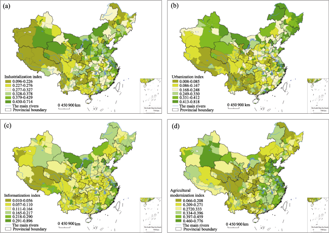
Figure 1 Spatial patterns of development level of industrialization, informatization, urbanization and agricultural modernization
(1) The average of industrialization development index is 0.327 (SD (standard deviation) = 0.102; CV (variation coefficient) = 0.311). Prefectures with higher industrialization index are mainly located in the eastern coastal regions like Bohai Rim Region, Yangtze River Delta, Pearl River Delta, relatively developed areas along the Yangtze River and some prefectures with rich mineral resources in north China. Prefectures with lower value are mainly distributed in the hilly area of the southwest and the Qinghai-Tibet Plateau.
(2) The average of urbanization development index is 0.248 (SD=0.163, CV=0.657). Regions with index value higher than average are mainly distributed in developed regions of eastern coastal China, old industrial bases in Northeast China, mineral-rich areas in northwest China, and core cities in inland China. The urbanization level of traditional agricultural areas in central China, hilly areas in southwest China and most areas in northwest China are relatively low.
(3) The average of informatization development index is 0.164 (SD=0.107, CV=0.656). Its spatial pattern is similar to that of urbanization development index. Regions with higher values are also distributed in the eastern coastal areas, old industrial bases in northeast China, mineral-rich areas in northwest China, while regions with lower index value are mainly distributed in central China, southwest hilly areas and most northwestern China.
(4) The average of agricultural modernization development index is 0.333 (SD=0.125, CV=0.376). Regions with higher values are mainly located in the Huang-Huai-Hai Plain, the middle and lower reaches of the Yangtze River, and southeast coast areas, while prefectures with lower values are mainly located along the Hu Huangyong Line, a “geo-demographic demarcation line” discovered by Chinese population geographer Hu Huanyong in 1935 (Long and Li, 2012), with complex and diverse natural geographical conditions.

3.2 The coordinated development status of Sihua

The comprehensive development level of Sihua can be calculated based on formula 2 (Mean=0.268, SD=0.100, CV=0.374). Regions with higher values are mainly distributed in eastern coastal areas and some prefecture cities in the northeast and northwest areas (Figure 2a). Those with lower value are mainly distributed in the central areas, southwest hilly areas, the Qinghai-Tibet Plateau and along the Hu Huangyong Line.
Further, the coupling degree was calculated by formula 3 (Mean=0.902, SD=0.077, CV=0.085). Regions with higher coupling degrees are mainly distributed in the eastern coastal areas, northeast areas, Sichuan-Shaanxi-Gansu border area and most of Chongqing, Inner Mongolia and Xinjiang (Figure 2b). Those with lower coupling degree are mainly distributed in the central traditional agricultural areas, southwest hilly areas and most of the Qinghai-Tibet Plateau.
The coordinated development level of Sihua is calculated by formula 4 (Mean=0.485, SD=0.104, CV=0.214). Regions with higher coordination index are mainly distributed in eastern coastal areas and northeast and northwest areas, while coordination index in the southeast China and the Qinghai-Tibet Plateau is much lower (Figure 2c). The regional pattern of the coordination index is well consistent with the dynamic pattern of China’s rural development. The coordination types of Sihua is classified according to the coordination index. Therefore, it can be concluded that the coordination development of Sihua in China is still at a low level and has significant regional differences (Figure 2d).
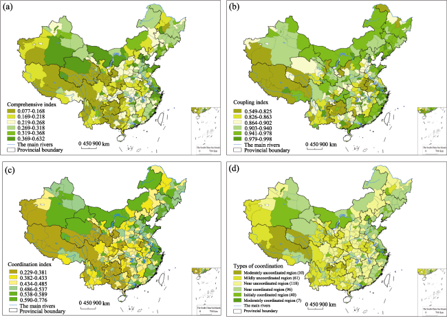
Figure 2 Spatial patterns of comprehensive development level and coupling and coordination degrees of industrialization, informatization, urbanization and agricultural modernization

3.3 Factors affecting the coordinated development of Sihua

Multivariate regression model was employed to detect factors affecting the regional differ- ence of China’s coordination degree of Sihua, and least squares estimation was used to estimate this model. As we can see from Table 2, the large- and medium-sized enterprise development, road infrastructure, urban and rural residents’ consumption, as well as agricultural and social investment, financial investment and financial support for rural areas have positive impact on the coordinated development of Sihua, while the investment in urban development and education did not pass the significance test. As such, to effectively promote the coordinated development of Sihua in the new era, we should continue to increase the financial investment and financial support for agriculture in rural areas, expand the domestic demand actively, guide the social capital to invest in rural areas, provide a more relaxed institutional environment for medium and small business development, and improve the road infrastructure in remote areas. In addition, improving the efficiency of investment in urban development and education is also important.
Table 2 Determinations of the coordinated development of Sihua
Variables Coefficient (t-Statistic) P
Constant 0.3155419 (26.717) 0.000
Urban fixed asset investment per capita (yuan/person) -0.0000001 (-0.819) 0.413
Rural fixed asset investment per capita (yuan/person) 0.0106130*** (3.227) 0.001
Local fiscal expenditure on education per capita (yuan/person) -0.0000151 (-1.378) 0.169
Local fiscal expenditure on agriculture, forestry and water conservancy per capita (yuan/person) 0.0000468*** (3.297) 0.001
Rural agricultural loans per capita (yuan/person) 0.0000123*** (4.353) 0.000
Output proportion of large/medium-sized enterprise (%) 0.0778983*** (4.924) 0.000
Ratio of total value of imports and exports to GDP (%) 0.0272937* (1.867) 0.063
Total retail sales of social consumer goods per capita (yuan/person) 0.0000101*** (15.377) 0.000
Road density (km/km2) 0.0072736* (1.720) 0.086
Statistical test
R2 0.738
Adjusted R2 0.730
F 100.613
Significant 0.000

Note: *** significant at the 0.01 level (P<0.01); ** significant at the 0.05 level (P<0.05); * significant at the 0.10 level (P<0.10).

4 Problem regions and regional problems

4.1 Identification of problem regions and regional problems from the perspective of Sihua development

Based on the seven criteria established before, problem regions could be identified using Spatial Query Tool of ArcGIS. The result shows that 29 prefectures meet the first criterion with very low industrialization index, 90 prefectures meet the second criterion with very low informatization index, 106 prefectures meet the third criterion with very low urbanization index, 50 prefectures meet the fourth criterion with very low agricultural modernization index, 45 prefectures meet the fifth criterion with very low comprehensive index, 8 prefectures meet the sixth criterion with very low coordination index of Sihua development, and 42 prefectures meet the seventh criterion with relative low residuals. However, some prefectures meet more than one criterion at the same time, as such, 145 prefectures have been identified based on spatial overlay analysis. The proportions of the area and population of these 145 prefectures accounted for 52.46% and 44.60% of China, respectively.
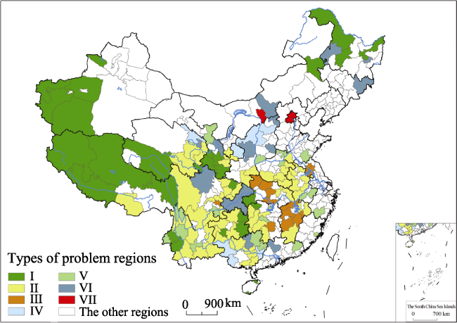
Figure 3 The spatial pattern of problem regions
Furthermore, the 145 problem prefectures could be divided into seven categories according to their status of Sihua development (Figure 3), and the basic socio-economic characteristics of the seven types of problem regions are shown in Table 3. A brief introduction of these problem regions and corresponding major regional problems are as follows:
Table 3 The basic characteristics of problem regions identified
Indicators Others Total/average
Land area/ 104 km2 229.8 139.2 19.5 21.6 28.0 45.6 3.4 441.3 928.3
Population/ 104 person 5994 28934 6153 2276 7088 6572 1517 72698 131231
GDP per capita/ yuan 9285 10275 15623 16777 16507 20455 90969 37038 27198
Industrialization index 0.151 0.262 0.319 0.323 0.305 0.344 0.268 0.378 0.327
Informatization index 0.107 0.075 0.080 0.122 0.128 0.166 0.429 0.209 0.164
Urbanization index 0.168 0.089 0.192 0.108 0.118 0.273 0.579 0.330 0.248
Agricultural modernization index 0.243 0.261 0.350 0.138 0.335 0.177 0.423 0.388 0.333
Comprehensive index 0.167 0.172 0.235 0.173 0.221 0.240 0.425 0.326 0.268
Coupling index 0.835 0.818 0.872 0.849 0.882 0.933 0.959 0.942 0.902
Coordination index 0.366 0.373 0.452 0.381 0.440 0.471 0.633 0.550 0.485
(1) Category I: Comprehensive lagged type with rather low level of Sihua development. This type including 29 prefectures is mainly distributed in mountainous regions of southwest, northwest, and northeast China, and the Qinghai-Tibet Plateau. The major constraints on development in these regions are the complex natural and geographical conditions and fragile ecological environment.
(2) Category II: Urbanization and informatization lagged type. This type including 60 prefectures is mainly distributed in southwest hilly areas and most of northern Anhui and eastern Henan in the Huang-Huai-Hai traditional agricultural areas. Industrialization gradually started in these areas, but agriculture is still the dominant industry. Due to vast out-migration, the pace of urbanization and informatization in these areas is rather slow.
(3) Category III: Informatization lagged type. This type including 13 prefectures is mainly distributed in northern Jiangxi, middle Hubei and northern Jiangsu, with the level of informatization development lower than half of the national average.
(4) Category IV: Urbanization and agricultural modernization lagged type, including 8 prefectures is mainly distributed in Loess Plateau and Guangxi and other places predominated by old revolutionary and mountainous areas. There are many mountains in these areas, thus restricting the development of cities and towns, and the transformation of traditional agriculture to a modernized one.
(5) Category V: Urbanization lagged type, including 19 prefectures, is distributed sporadically in the mountainous provincial border areas. In general, the central cities and towns in these areas have less capability in attracting investment and labors, and thus these prefectures are usually suffering from the massive out-migration of rural population.
(6) Category VI: Agricultural modernization lagged type, which includes 14 prefectures. Similarly, most of these prefectures are located in mountainous interprovincial border regions. There are many mountains in these areas, and the majority of the land is not suitable for large-scale agriculture.
(7) Category Ⅶ: Relatively inefficient type, which consists of two cities, namely Beijing and Hohhot. The evaluation values of coordinated development of Sihua in the two cities are obviously lower than their predictions, revealing that their input-output efficiency is quite low. Thus, more efforts should be made to raise the efficiency of Sihua development of the two cities.

4.2 Comparative case studies

In order to better understand the problem regions and regional problems, three prefectures, namely Zhoukou, Yulin and Chongqing, which belong to urbanization and informatization lagged type (Ⅱ), urbanization and agricultural modernization lagged type (Ⅳ), and agricultural modernization lagged type (Ⅵ), respectively, have been chosen for brief comparative case studies. Table 4 shows the basic socio-economic characteristics of the three case study areas.
Table 4 The basic characteristics of case study areas
Indicator Zhoukou Yulin Chongqing
Land area (104 km2) 1.20 4.31 8.24
Population (104 person) 1091 359 3276
Net migration (104 person) -219 -32 -430
Urbanization rate (%) 12.45 18.32 27.86
GDP per capita (yuan) 9769 36265 19935
Fixed investment per capita (yuan) 6332 23678 16235
Urban fixed investment per capita (yuan) 4531 19175 15138
Budget revenues per capita (yuan) 283 2539 2082
Grain production per capita (kg) 657 426 347
Effective irrigation rate (%) 71.83 21.36 30.06
Industrialization index 0.291 0.464 0.331
Informatization index 0.060 0.175 0.161
Urbanization index 0.061 0.127 0.252
Agricultural modernization index 0.350 0.136 0.167
Comprehensive index 0.191 0.226 0.228
Coupling index 0.724 0.788 0.952
Coordination index 0.372 0.422 0.465
Zhoukou Prefecture, located in the hinterland of Huang-Huai-Hai Plain Region, stands for China’s traditional agricultural area. Since the implementation of the Rise of Central China Plan (Dunford and Li, 2011), the industrialization in this region has undergone a steady increase, but agriculture still accounts for a large proportion of GDP. More than half of the region’s labors still work in agricultural sector and the income of both urban and rural residents is relatively low. Due to vast out-migration of rural population (Li et al., 2014), the pace of urbanization and informatization in these areas is rather slow (Table 4). Thus, more efforts should be made to guide the industrial development of central cities and towns, increase input and create better conditions for grain production, and improve the infrastructure of urban and rural areas, so as to enhance the capability of cities and towns for creating employment and attracting population. Briefly, in this type of problem region, regional policies should focus more on the sustainable development of local agro-based industry and improvement of urban system and public infrastructure.
Yulin Prefecture, located in the core area of the Loess Plateau, represents China’s farming-pastoral zone. Since the implementation of the Grain for Green Programme (Long, 2014; Li et al., 2013), the human-environment relationship has changed a lot. Specifically, this region’s ecological environment has been improved significantly and experienced a significant reduction in slope farmland (Liu et al., 2010). Because of the rich mineral resources, mining, energy and chemical industries developed rapidly. Restricted by natural and geographical environment, construction land for urbanization development is limited, and natural conditions for agricultural production can hardly meet the needs of large-scale modernized agricultural production. Henceforth, regional policies should focus more on increasing regional carrying capacity and the transformation of traditional subsistence agriculture to high-efficiency agriculture with local characteristics.
Chongqing Municipality, featured by mountains and fogs, is located on the upper reaches of the Yangtze River. The establishment of the municipality in 1997 made this region under the direct supervision of the Central Government, while the introduction of Western China Development Program in 1999 brought new vigor to Chongqing (Long et al., 2008; Li et al., 2013), which indicated that industrialization and urbanization developed fast in the past decade. However, the problem of ‘using big city to pull the development of large rural area’ still existed. Sustainable rural development and agricultural modernization will be important themes in this type of region for a long time. Regional policies should pay more attention to pushing forward the ‘Urban-rural Integrated Reform,’ and developing certain rural functions to serve the urban areas, such as attracting industrial transfer from eastern China, providing high quality food, ecological and other kinds of services for urban population.
Overall, it can be concluded that, our criteria could identify the problem regions effectively and could also help to understand the various regional problems through a set of key indicators from the perspective of the coordinated development of industrialization, informatization, urbanization and agricultural modernization.

5 Discussion

The industrialization development index, urbanization development index, informatization development index and agricultural modernization development index of China’s 332 prefecture-level administrative units have been evaluated in this paper, and comprehensive development index, coupling development index and coordinated development index of the four indices have been calculated also. To a large extent, these indices can reveal the diverse patterns of China’s socio-economic development effectively. However, the meaning of the Sihua development is far more abundant than that reflected by the current indicator system. For example, due to lack of data, it is hard to wholly describe the urbanization quality, new industrialization and agricultural modernizations and it is prone to bias in the evaluation of the resource-based cities, tourism cities and post-industrial cities as well. Moreover, it is still worth further discussing the mechanism, regional development mode and multi-scale features of the coordinated development of Sihua. In addition, the problem regions identified in this paper is still preliminary. It is urgently needed to carry out further studies on the method of identifying problem regions more in line with the national conditions of recent China.
Even so, it can be confirmed both in this study and previous studies that China’s Sihua development and socio-economic development have obvious spatial difference and show diverse regional patterns, especially at the meso scale (Zhang et al., 2011). Different regions tend to have different problems and thus need different preferential policies. As such, the traditional one-size-fits-all policies should be improved timely (Li et al., 2013). In fact, as a positive response to the vast regional differences, the central government of China has promulgated a series of regional policies including the Western Development Program, the Revitalization of the Old Northeast Industrial Bases Strategy and the Rise of Central China Plan (Dunford and Li, 2011). Moreover, dozens of regional plans, such as Binhai new area in Tianjin, Liangjiang new area in Chongqing, Lanzhou new area in Lanzhou, Wanjiang new area in Anhui and so on, have been promoted as national strategies since 2005. Recently, 14 concentrated poverty regions have been identified also and the majority of relevant plans in these regions are under planning or even implementation.
There is no doubt that these newly introduced regional plans and corresponding regional policies enrich the existing regional planning system of China. However, these local and national responses are questionable more or less in the meantime (Chen, 2010; Liu, 2013; Zhang et al., 2012). Firstly, mesoscale regional policies have been ignored. The spatial scale of current regional policies and regional plans are at macro scale or micro scale. The areas of these regions range from millions of square kilometers to hundreds of square kilometers, which are either too large or too small. Secondly, some institutional factors constraining regional development of China in the past decades still exist and are playing negative roles, and it is still very difficult to promote interregional cooperation. Thirdly, some of these regional plans have their obvious regional characteristics, but most of these regional plans have strong homogeneity, and the majority of them just try to gain Central Government’s supports of finance and tax policies and quotas of construction land. Concerning the orientation of industrial development, overall planning at the national level is still in urgent need. Fourthly, these local responses became new outcomes of regional competition and acted as important tools for urban expansion. Overall, current local responses’ effects on national and regional development need further investigation and evaluation. The mismatch between regional policies/plans and the actual local needs may constrain the sustainable development of various regions.
As such, we suggest that China’s regional policy in the new period should fully recognize the diversity of local space at an appropriate scale. According to our exploratory study on Sihua development, regional policies focusing on the transformation development of less-developed regions should pay special attention to the traditional agricultural areas of central China, southwest hilly areas and the Qinghai-Tibet Plateau, which are China’s major grain producing areas, key areas for biodiversity conservation, and significant ecological fragile region, respectively. They are now suffering from outflow of high-quality labor force and faced with various difficulties in industrialization, urbanization and rural development. Furthermore, the southwest hilly areas and the Qinghai-Tibet Plateau are also facing complex topography, fragile ecological environment and other physical issues. In the new era of urban-rural transformation, these problem regions are the important ecological barrier and rear of national socio-economic development, and also the key points of optimizing land development space, promoting synchronous development of Sihua, and accelerating the ecological civilization construction.

6 Conclusion

This paper evaluated the industrialization development index, urbanization development index, informatization development index and agricultural modernization development index of China’s 332 prefecture-level administrative units, and calculated their comprehensive development index, coupling development index and coordinated development index. It was found that these indices have obvious spatial differences and show diverse regional patterns. 145 prefecture-level cities, mainly located in central traditional agricultural areas, southwest hilly areas and the Qinghai-Tibet Plateau, have been identified as problem regions according to the holistic state of Sihua development. The comparative case studies showed that the results of identification can effectively reflect the basic state of regional development. As far as regional policy is concerned, it is suggested that, more attention should be paid to the development of central traditional agricultural areas, southwest hilly areas and the Qinghai-Tibet Plateau. Overall, this study enhanced our knowledge of coordinated development of industrialization, informatization, urbanization and agricultural modernization, and may benefit the improvement of China’s regional policies and thus contribute to the sustainable development of China in the new era of urban-rural transformation.

The authors have declared that no competing interests exist.

1
Chen Cai, 2010

2
Chen Jiagui, Huang Qunhui, Zhong Hongwu, 2006. The synthetic evaluation and analysis on regional industrialization.Economic Research Journal, (6): 4-15. (in Chinese)

3
Chen Mingxing, Lu Dadao, Zhang Hua, 2009. Comprehensive evaluation and the driving factors of China's urbanization.Acta Geographica Sinica, 64(4): 387-398. (in Chinese)

4
Damesick P, Wood P A, 1987. Regional Problems, Problem Regions, and Public Policy in the United Kingdom. Oxford: Clarendon Press.

5
Ding Zhiwei, Zhang Gaisu, Wang Fazeng, 2013. The internal mechanism and quantitative analysis of coordination development of industrialization, urbanization and agricultural modernization of Zhongyuan Economic Region.Scientia Geographica Sinica, 33(4): 402-409. (in Chinese)

6
Dunford M, Li L, 2010. Chinese spatial inequalities and spatial policies.Geography Compass, 4(8): 1039-1054.

7
Fan Jianyong, Gao Renyuan, Zhang Yan, 2010. Spatial efficient and strategic choice of regional coordinated development.The Journal of World Economy, 2: 104-119. (in Chinese)

8
Fan Jie, Li Pingxin, 2009. The scientific foundation of Major Function Oriented Zoning in China.Journal of Geographical Sciences, 19(5): 515-531.

9
Fang Chuanglin, Liu Xiaoli, Lin Xueqin, 2008. Stages correction and regularity analysis of urbanization course of China.Arid Land Geography, 31(4): 512-523. (in Chinese)

10
Gu Chaolin, Yu Taofang, Li Wangming et al., 2008. Urbanization of China: Pattern, Process, Mechanism. Beijing: Science Press. (in Chinese)

11
Jiang Heping, Huang Delin, 2006. Economic evaluation of China agricultural modernization.Research of Agricultural Modernization, 27(2): 87-91. (in Chinese)

12
Jiang Huiming, Wang Zhenhua, 2012. Empirical analysis on the relationship among industrialization, urbanization and agricultural modernization in Jilin Province.Scientia Geographica Sinica, 32(5): 591-595. (in Chinese)

13
Li Jiuyi, Li Lijuan, 2012. Water resources supporting capacity to regional socio-economic development of China.Acta Geographica Sinica, 67(3): 410-419. (in Chinese)

14
Li Xiaojian, Qiao Jiajun, 2001. County level economic disparities of China in the 1990s. Acta Ceographica Sinica, 56(2): 136-145. (in Chinese)

15
Li Yingru, Wei Yehua, 2010. The spatial-temporal hierarchy of regional inequality of China.Applied Geography, 30(3): 303-316.

16
Li Yurui, Liu Yansui, Long Hualouet al., 2013. Local responses to macro development policies and their effects on rural system in China’s mountainous regions: The case of Shuanghe Village in Sichuan Province.Journal of Mountain Science, 10(4): 588-608.

17
Li Yurui, Liu Yansui, Long Hualouet al., 2014. Community-based rural residential land consolidation and allocation can help to revitalize hollowed villages in traditional agricultural areas of China: Evidence from Dancheng County, Henan Province.Land Use Policy, 39: 188-198.

18
Li Yurui, Wang Jing, Liu Yansuiet al., 2014. Spatial pattern and influencing factors of the coordination development of industrialization, informatization, urbanization and agricultural modernization in China: A prefecture level exploratory spatial data analysis.Acta Geographica Sinica, 69(2): 199-212. (in Chinese)

19
Liao Chongbin, 1999. Quantitative judgment and classification system for coordinated development of environment and economy: A case study of the city group in the Pearl River Delta.Tropical Geography, 19(2): 171-177.

20
Liu Hui, 2006. Changing regional rural inequality in China 1980-2002.Area, 38(4): 377-389.

21
Liu Weidong, Liu Yi, Qin Yucai et al., 2009. Regional Development Report of China in 2009. Beijing: The Commercial Press.

22
Liu Yansui, 2007. Rural transformation development and new countryside construction in eastern coastal area of China.Acta Ceographica Sinica, 62(6): 563-570. (in Chinese)

23
Liu Yansui, Chen Yangfen, Long Hualou, 2011. Regional diversity of peasant household response to new countryside construction based on field survey in eastern coastal China.Journal of Geographical Sciences, 21(5): 869-881.

24
Liu Yansui, Zhang Yanyu, Guo Liying, 2010. Towards realistic assessment of cultivated land quality in an ecologically fragile environment: A satellite imagery-based approach.Applied Geography, 30(2): 271-281.

25
Liu Yuhai, 2013

26
Long Hualou, 2014. Land use policy in China: Introduction.Land Use Policy, 40: 1-5.

27
Long Hualou, Li Tingting, 2012. The coupling characteristics and mechanism of farmland and rural housing land transition in China.Journal of Geographical Sciences, 22(3): 548-562.

28
Long Hualou, Liu Yansui, Li Xiubinet al., 2010. Building new countryside in China: A geographical perspective.Land Use Policy, 27(2): 457-470.

29
Long Hualou, Wu Xiuqin, Wang Wenjieet al., 2008. Analysis of urban-rural land-use change during 1995-2006 and its policy dimensional driving forces in Chongqing, China.Sensors, 8(2): 681-699.

30
Long Hualou, Zou Jian, Pykett Jet al., 2011. Analysis of rural transformation development in China since the turn of the new millennium.Applied Geography, 31(3): 1094-1105.

31
Peng Peng, 2008. Research on identification of problem regions [D]. Beijing: Renmin University of China.

32
Qian Li, Chen Zhongwei, Xiao Renqiao, 2012. Analysis of coordinated degree of China’s regional industrialization, urbanization and agricultural modernization and is influencing factors.Inquiry into Economic Issues, (11): 10-17. (in Chinese)

33
Tang Li, Yao Shujie, Wang Jianjun, 2006. Analyzing income disparity of urban households in China by the decomposition of Gini Coefficient.The Journal of Quantitative & Technical Economics, 11: 31-37. (in Chinese)

34
Wei Yehua, Ye Xinyue, 2009. Beyond convergence: Space, scale, and regional inequality in China.Tijdschrift voor Economische en Sociale Geografie, 100(1): 59-80.

35
Wu Dewen, Mao Hanying, Zhang Xiaoleiet al., 2011. Assessment of urban land use efficiency in China.Acta Geographica Sinica, 66(8): 1111-1121. (in Chinese)

36
Xia Chunping, Liu Wenqing, 2012. Empirical research on the compatible relationship of the development of industrialization, urbanization and agricultural modernization in China.Journal of Agrotechnical Economics, (5): 79-85. (in Chinese)

37
Xie Jie, 2012. A research on threshold effects of industrialization and urbanization on the process of agricultural modernization.Issues in Agricultural Economy, (4): 84-90. (in Chinese)

38
Xie Kang, Xiao Jinghua, Zhou Xianboet al., 2012. Quality of convergence between industrialization and informatization in China. Economic Research Journal,(1): 4-16, 30. (in Chinese)

39
Xu Dawei, Duan Shanshan, Liu Chunyan, 2012. Research on the internal mechanism and interaction relationship of the simultaneous development of the development on industrialization, urbanization and agricultural modernization in China: Based on collaboration and mechanism design theory.Issues in Agricultural Economy, (2): 8-13. (in Chinese)

40
Yang Xiaohuan, Ma Hanqing, 2009. Natural environment suitability of China and its relationship with population distributions.International Journal of Environmental Research and Public Health, 6: 3025-3039.

41
Ying Longgen, 2003. Understanding China’s recent growth experience: A spatial econometric perspective.Annals of Regional Science, 37(4): 613-628.

42
Zhang Keyun, Hu Naiwu, 2004. Essential regional problems and coordinated development of different regions in China.Journal of Capital University of Economics and Business, 2: 8-13. (in Chinese)

43
Zhang Yushu, Pei Xia, Xie Gaodiet al., 2012. The status and formation mechanism of China’s new functional zones.Resources Science, 34(9): 1647-1655. (in Chinese)

Outlines

/