
Journal of Geographical Sciences >
Detecting climate change effects on forest ecosystems in Southwestern Romania using Landsat TM NDVI data
Author: Remus Pravalie, E-mail: pravalie_remus@yahoo.com; Igor Sîrodoev, E-mail: ingvarr_i@yahoo.com; Daniel Peptenatu, E-mail: peptenatu@yahoo.fr
Received date: 2013-08-12
Accepted date: 2014-02-12
Online published: 2014-05-20
Copyright
Nowadays, Southwestern Romania faces a large-scale aridization of the climate, revealed by the rise of temperatures and the decline of the amount of precipitations, with negative effects visible, among others, in the desiccation of forest vegetation. The present study means to identify the changes that occurred, quality-wise, in the past two decades (1990-2011) in forest vegetation in Southwestern Romania, and to establish the link between those changes and extant thermal stress in the region, whose particular features are high average annual and seasonal temperatures. In order to capture the evolution in time of climate aridization, a first step consisted in using climate data, the temperature and precipitation parameters from three weather stations; these parameters were analyzed both individually and as aridity indexes (De Martonne and UNEP). In order to quantify the changes in forest vegetation, NDVI indexes were used and analyzed, starting off from Landsat satellite images, acquired at three distinct moments in time, 1990, 2000 and 2011. In order to identify the link between the changes of NDVI index values and regional thermal stress, a yardstick of climate changes, statistical correlations were established between the peak values of average annual temperatures, represented in space, and negative changes in the NDVI index, as revealed by the change-detection analysis. The results obtained indicated there is an obvious (statistically significant) connection between thermal stress and the desiccation (degradation) of forest species in the analyzed area, with false acacia (Robinia Pseudoacacia) the main species to be impacted.
Key words: thermal stress; forest ecosystems; NDVI index; change detection analysis
Remus PRAVALIE , Igor SÎRODOEV , Daniel PEPTENATU . Detecting climate change effects on forest ecosystems in Southwestern Romania using Landsat TM NDVI data[J]. Journal of Geographical Sciences, 2014 , 24(5) : 815 -832 . DOI: 10.1007/s11442-014-1122-2
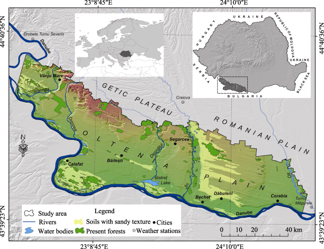
Figure 1 Location of the study area in Romania |
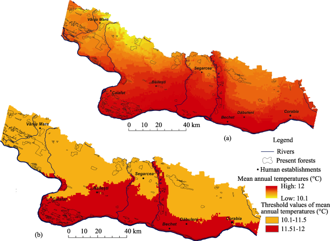
Figure 2 Spatial representation of average annual temperatures (1950-2000) in the analyzed area (a); spatial representation of threshold-values selected among average annual temperatures (b) (processed WorldClim.org data) |
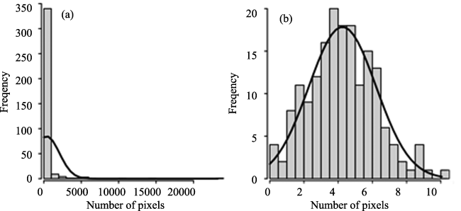
Figure 3 Example of data distribution (NDVI > 0.5) before (a) and after (b) standardization |
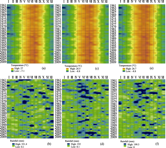
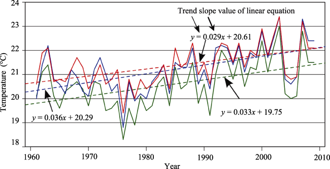
Figure 4 Annual fluctuation of the average monthly temperatures and precipitations (1961-2009), at the Drobeta Turnu Severin (a, b), Craiova (c, d) and Turnu Măgurele (e, f) weather stations |
Figure 5 Annual fluctuation (1961-2009) of average monthly temperatures, during the time of peak biological activity (May-August) |
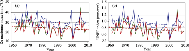
Figure 6 Multi-annual fluctuation of the De Martonne (a) and UNEP (b) aridity indexes and linear trends at the Craiova, Drobeta Turnu Severin and Turnu Magurele weather stations (1961-2009) |
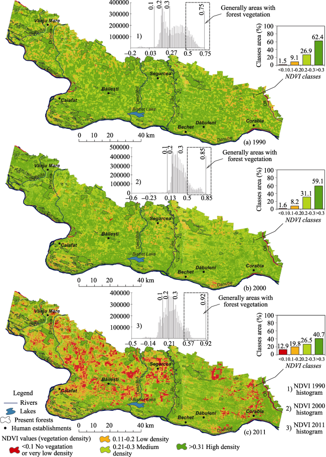
Figure 7 Spatio-temporal evolution of the NDVI index during 1990-2011 |
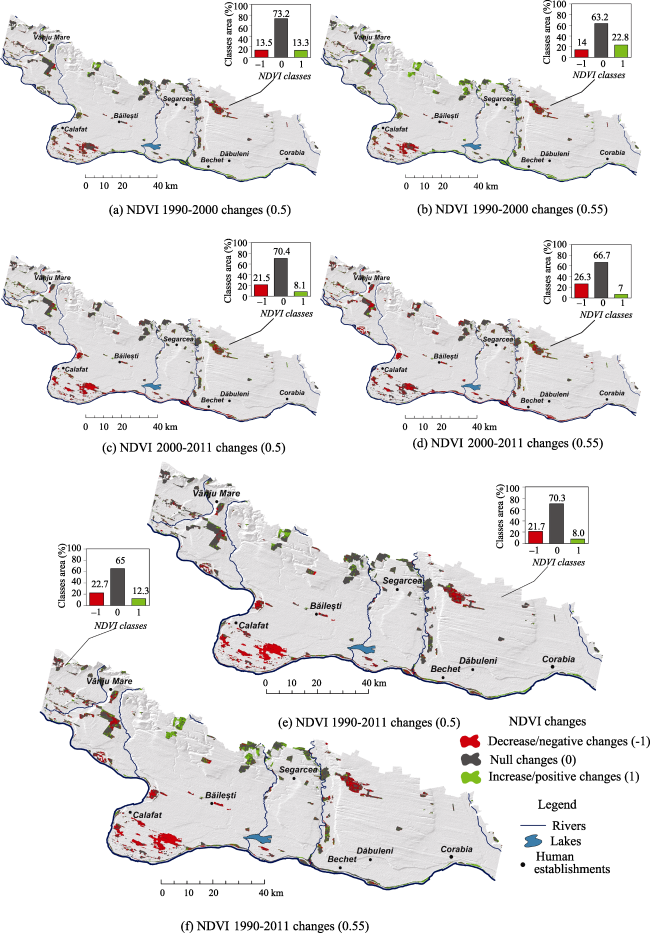
Figure 8 Change-detection analysis in terms of the NDVI index during 1990-2011 |
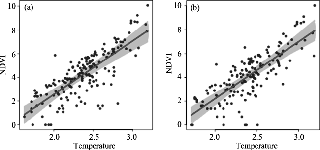
Table 1 Output of NDVI vs. temperature linear regression models for two cases: NDVI > 0.5 and NDVI > 0.55 |
| Case | Correlation coefficients | Intercept | Slope | 95% confidence interval for slope |
|---|---|---|---|---|
| NDVI > 0.5 | 0.625 | -6.45 | 4.51 | [3.99; 5.04] |
| NDVI > 0.55 | 0.618 | -7.40 | 4.81 | [4.25; 5.38] |
Figure 9 NDVI vs. temperature (>11.5℃) (both measured in number of pixels per forest body): a) for NDVI > 0.5; b) for NDVI > 0.55. Legend: blue points - observations; red line - regular regression line; gray array - regression lines for each of 1000 bootstrap replicates |
The authors have declared that no competing interests exist.
| 1 |
|
| 2 |
|
| 3 |
|
| 4 |
|
| 5 |
|
| 6 |
|
| 7 |
|
| 8 |
|
| 9 |
|
| 10 |
|
| 11 |
|
| 12 |
|
| 13 |
|
| 14 |
|
| 15 |
|
| 16 |
|
| 17 |
|
| 18 |
IPCC, 2007. Climate Change 2007: The Physical Science Basis. Contribution of Working Group I to the Fourth Assessment Report of the Intergovernmental Panel on Climate Change. Cambridge, Cambridge University Press, 996p.
|
| 19 |
|
| 20 |
|
| 21 |
|
| 22 |
|
| 23 |
|
| 24 |
|
| 25 |
|
| 26 |
|
| 27 |
|
| 28 |
|
| 29 |
|
| 30 |
|
| 31 |
|
| 32 |
|
| 33 |
|
| 34 |
|
| 35 |
|
| 36 |
|
| 37 |
|
| 38 |
|
| 39 |
UNEP, 1992. World Atlas of Desertification. London, UK: Edward Arnold.
|
| 40 |
|
| 41 |
|
| 42 |
|
| 43 |
|
| 44 |
|
| 45 |
(1997) Jiana forestry-planning document. General Study.Institutul de Cercetari si Amenajări Silvice Voluntari.
|
| 46 |
(2004) Calafat forestry-planning document. General Study.Institutul de Cercetari si Amenajări Silvice Voluntari.
|
| 47 |
(2004) Poiana Mare forestry-planning document. General Study.Institutul de Cercetari si Amenajări Silvice Voluntari.
|
| 48 |
(2005) Orthophotomaps, 1:5000 scale. The National Agency of Cadastre and Real Estate Advertising (NACREA).
|
| 49 |
(2006) Corine Land Cover (CLC). European Environment Agency, www.eea.europa.eu.
|
| 50 |
(2010) Şimian forestry-planning document. General Study, Institutul de Cercetari si Amenajări Silvice Voluntari.
|
| 51 |
European Climate Assessment & Dataset (
|
| 52 |
|
| 53 |
|
| 54 |
|
/
| 〈 |
|
〉 |